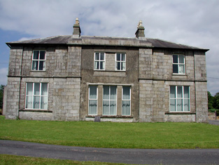
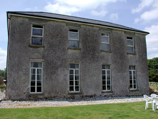
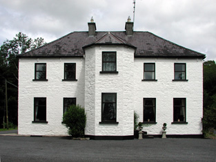
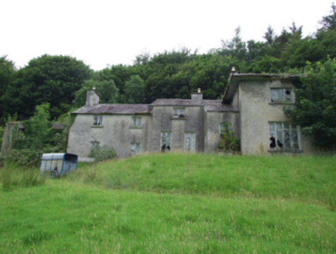
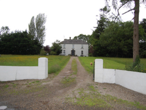
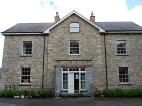
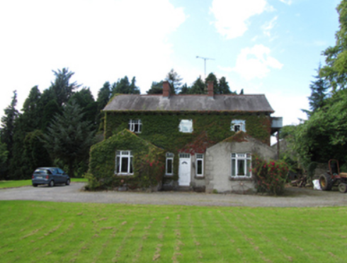
Carn House
Houses within 15km of this house
Displaying 74 houses.
Houses within 15km of Carn House
Displaying 74 houses.
| House name | Description | |
|---|---|---|
| Druminshin Glebe | Rev. James Agar held this property at Druminshin Glebe freehold at the time of Griffith's Valuation when it was valued at £30. The property seems to have been known as Carrigallen Glebe or Carrigallen Lodge at various times though it is recorded as Druminshin Glebe house on the first edition Ordnance Survey map. It is still extant and occupied. |
|
| Kilbracken | William Murray Hickson was leasing the house at Kilbracken, barony of Carrigallen, from Elizabeth Armstrong at the time of Griffith's Valuation when it was valued at £20. In 1814 a house at Kilbracken was recorded as the residence of Mr. Armstrong but it has been estimated that the present Kilbracken House was built around 1825. It is not named on the first edition Ordnance Survey map though there are buildings marked on the site. A poster in Leitrim County Library indicates that it was the property of Thomas S.Jones in 1905 when it was offered for sale. The house is still extant and undergoing restoration. |
|
| Killygar | It is estimated by the National Inventory of Architectural Heritage that Killygar was built in 1813. At the time of Griffith's Valuation Killygar House was occupied by John Godley and was valued at £43. It was also the residence of John Godley in 1814 and in 1837. In 1894 Slater refers to it as the seat of Archibald Godley. It is still extant and occupied by the Godley family. |
|
| Woodford | Woodford was the residence of Robert J. Gore at the time of Griffith's Valuation when it was valued at £15. In 1814 it was occupied by John Gore. Both Taylor and Skinner and Wilson also record it as a seat of the Gore family in the 1780s. The house at Woodford Demesne, described as "formerly the residence of the Rev. Gore" was "formerly a genteel residence but now in a ruinous state" at the time of the first Ordnance Survey in 1835. Lewis records it as the seat of Ormsby Gore in 1837. In 1906 it was the property of Emily Upperton and was valued at £19. The National Inventory of Architectural Heritage states that it retains little original fabric but much of the estate architecture, including the site of the walled garden survives. There is also an earlier castle at this site. |
|
| Cloghlough | At the time of Griffith's Valuation, William O'Brien was leasing a property valued at £8 at Cloghlough, barony of Carrigallen, from the estate of John King, which was in Chancery. Substantial farm buildings exist at this site. | |
| Drumsillagh | Acheson O'Brien was leasing the property at Drumsillagh, barony of Carrigallen, from the King estate (in chancery) at the time of Griffith's Valuation when it was valued at £15. Lewis also records it as a seat of the O'Brien family in 1837. In 1906 Drumsillagh was owned by the representatives of William A. O'Brien and was also valued at £15. There appears to be still a house at this site. | |
| Corduff House | The National Inventory of Architectural Heritage estimates that Corduff House was built c.1780. William Penrose was occupying the house at Corduff, barony of Carrigallen, at the time of Griffith's Valuation when it was valued at £8. Corduff House is recorded as the seat of the Penrose family by Lewis in 1837. In 1814 it was the residence of George Percy. The house is still extant and occupied. |
|
| Garadice | John Percy was leasing the house at Garadice, barony of Carrigallen, from the representatives of William Percy at the time of Griffith's Valuation when it was valued at £15. In 1814 it was noted as a residence of the Percy family. Lewis records it as the seat of W.C. Percy in 1837. In the 1780s both Taylor and Skinner and Wilson noted Garadice as a Percy residence. The ITA survey recorded it as much deteriorated in the 1940s. It also mentions the existence of a second house belonging to the Percy family in the townland of Carrickmakeegan. The buildings are still extant at Garadice. | |
| Clooncorick Castle | Formerly an O'Rourke castle, Clooncorrick was held by several other families, notably the Irwins, before being bought by Pierce Simpson in 1835. In 1814 it is recorded as the residence of Rev. Agar. At the time of Griffith's Valuation it was being leased by Pierce Simpson from the Ormsby Gore estate and was valued at £40. Lewis also records it as the seat of the Simpson family in 1837. In the 1930s the castle was dismantled and the fittings sold. The ITA survey in the 1940s recorded that the castle had recently been demolished. | |
| Boeeshil House | At the time of Griffith's Valuation William Shanley was leasing a property at Boeeshil, barony of Carrigallen, incuding a house and corn mill, valued at £20, from the Percy estate. There are three mills shown at the site on the 1st edition 6" OS map, including a corn, bleach and flax mill. Lewis records this property as belonging to the Gerard family. | |
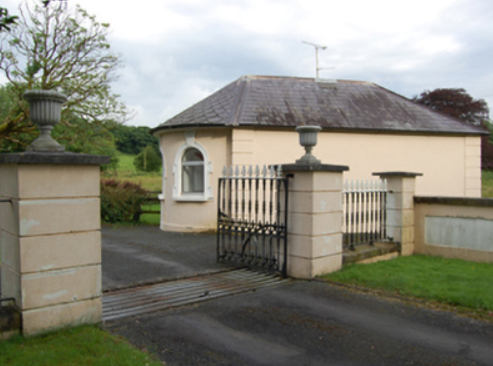
| Erne Hill House | Located on the outskirts of Belturbet, Erne Hill House was the home of George M. Knipe with a rateable valuation of £45, at the time of Griffith’s Valuation. By 1878 John E. Vernon was living at Erne Hill. The Knipe mausoleum is nearby and a gate lodge is extant but the house is demolished. |
|
| Sugarloaf | John Gumley of Sugarloaf died in 1794 (gravestone inscription Belturbet COI). Sugarloaf was located south east of Belturbet. In 1835 Theophilus Brinsley Butler of Dublin leased the house and gardens to Mary Finlay of Sugarloaf house, county Cavan, widow, for the lives of her son Sir Thomas Finlay and her daughter Elizabeth Lake Finlay. By the 1850s Samuel Knipe was resident holding the property from Captain Humphry Butler. It had a rateable valuation of £10.10.0. |
|
| Templeport House | Templeport House was built about 1860 on part of the Dobbin estate. It is situated north east of Templeport Lough and may occupy the site of a former herd’s house. Robert Roycroft of Templeport House died in 1881, aged 64 and was buried in Templeport graveyard. |
|
| Nixon Lodge/Griffith Lodge | A mid-18th century house, named Nixon Lodge on the first edition 6 inch Ordnance Survey map (publ. 1837). It was the home of the Reverend Andrew Nixon and his wife Marianne French of Frenchpark, county Roscommon, in the 18th century. Their son Humphrey had eight children. Nixon Lodge was later known as Griffith Lodge and Griffith’s Valuation records Dorothea Griffith as the occupant. She held the property in fee and the buildings were valued at £16.10.0. Occupied by the Smith family at the beginning of the 20th century. Somewhat reduced in size this house is still extant and occupied. | |
| Greenville (Cavan) | The Thorntons were located at Greenville from the 18th century. The house was situated east of Greenville Lough and north of Ardlougher. At the time of Griffith’s Valuation the buildings described as a house, steward’s house, offices and lodge were valued at £40 for rates. The property was held by Perrott Thornton in fee. In 1864 the Greenville estate of William Robert Thornton was advertised for sale in the Landed Estates Court including the house and demesne. In 1876 George Nugent, the owner of 400 acres in county Cavan, is recorded as resident at Greenville, Ardlougher. His estate including Greenville was for sale in November 1880 when the house was described as 'handsome, modern, substantially built, in excellent order, well supplied with water, and fit for the immediate reception of a large family'. The home of Lieutenant Colonel William Alexander Crawford Roe and his wife Emma in 1901 and of the Clifford sisters Olivia and Edith in 1911. In 1906, it was described as a 'mansion' with a rateable valuation of £40. The house is no longer in existence. | |
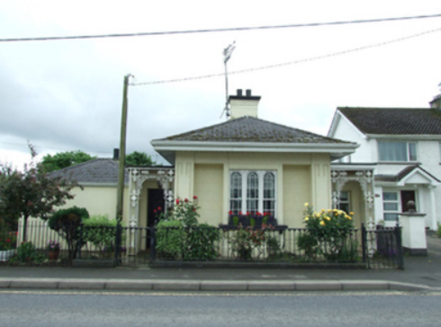
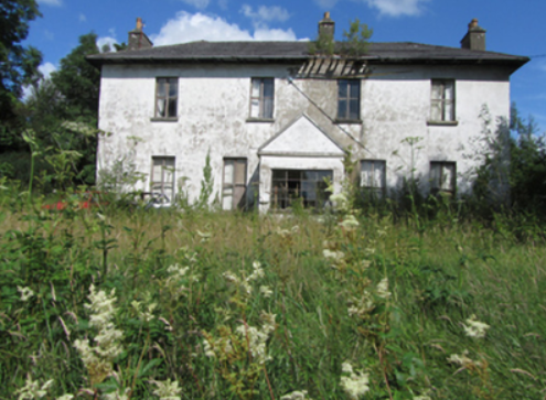
| Carn Cottage | Griffith’s Valuation records Captain Richard Clifford as owner and occupier and the building was valued at £28.15.0. At the beginning of the 20th century this house was the home of [retired] Lieutenant General Robert Cecil Richard Clifford, Indian Staff Corps and his wife and daughter. http://bygonedaysphotography.blogspot.ie/2016/08/two-clifford-sisters.html |
|
| Glendoon | At the time of Griffith's Valuation Moses Netterfield held offices and land in the townland of Doon, Ballyconnell, county Cavan, part of the estate of the Earl of Annesley. The National Inventory of Architectural Heritage describes this building as an 'early nineteenth-century house of simple Italianate design'. |
|
| Drumkeen | In 1814 ‘Dromkeen’ was the home of Robert Sanderson. Bence Jones writes that this was an early 19th century two storey house. The Ordnance Field Name Book states that it Kilbee resided 'in the old family mansion of Drumkeen house’. It was held in fee, valued at £30 and occupied by Colonel Alexander Saunderson in the mid-19th century. In 1901, it was occupied by Arthur Trench, in 1906 by Lucas Clements when its rateable valuation had risen to £55 and in 1911 by Agnes Jane Clements and her daughter. Bought by the Loreto nuns in 1930, the building has since been altered. |

|
| Castle Saunderson | A house built in the late 1830s incorporating an earlier building. It was the home of the Saunderson family, occupied by Colonel Alexander Saunderson in the 1850s and held by him in fee; it had a rateable valuation of £54 which had risen to £84 by 1906. This building was unoccupied and derelict in the 1990s. However it is now the location of an International Scouting Centre which opened in 2012. |

|
| Cloverhill | This three storey mansion was built in the early years of the 19th century to the design of Francis Johnston. Attached to the rear was an earlier two storey house dating from 1758. In 1814 Cloverhill was the home of James Saunderson. The Ordnance Survey Field Name Book describes Cloverhill as ‘a neat dwelling house with portico of the Ionic order, is in the centre of the townland, in good order, well planted about good orchards, gardens etc’. Griffith’s Valuation records Mary. A. Saunderson as the occupier holding the property in fee. It had a rateable valuation of £40. Cloverhill passed to the Winter family through the marriage in 1826 of Lucy, daughter of James Sanderson, to Samuel Winter of Agher, county Meath. Their third son, Samuel Winter, born 1834, inherited Cloverhill. He died in 1905 and Cloverhill passed to his nephew, John James Purdon, who died unmarried in 1933. The house was sold in the late 1950s by J.J. Purdon’s nephew, Major John Nugent Purdon. It is now an ivy clad ruin. |

|
| Cullies House | Cullies House had a rateable valuation of £35 at the time of Griffith’s Valuation and was occupied by Nathaniel Montgomery and held from Edward K. Tenison. The entrance gates, lodge and outbuildings have become part of the St Patrick’s College complex. This house was demolished circa 1980 (National Inventory of Architectural Heritage]. |
|
| Annagh House | Annagh, situated close to Annagh Lough, was the home of Robert Baker in 1814. Occupied and held in fee by Captain John O’Reilly in the mid-19th century, the house is now demolished. | |
| Nahillah House | Nahillah House was built in the mid-19th century for the Jones family. Griffith’s Valuation records the buildings valued at £16 and held by the representatives of John C. Jones in fee. Home of David Fielding Jones in 1862 (Thom’s Directory), the house became the home of the Cole family in the 20th century and is still extant. | |
| Leggykelly Cottage | Named on the first edition six inch Ordnance Survey map (publ. 1837), this house was occupied by Theophilus Thompson and held from the Reverend E.B.W. Venables in the 1850s. Its rateable valuation was £5. An extended building now occupies the site. | |
| Prospect House (Cavan) | The National Inventory of Architectural Heritage dates the building of this house to about 1770. Slater’s Directory records John Thompson of Prospect House in 1846. At the time of Griffith’s Valuation this house was vacant but held by Mary A. Sanderson of Cloverhill. This house is now a ruin. |
|
| Ardue House | Ardue House was the home of the Clemengers, a family of German origin, throughout the 19th century. Mr Clemenger was resident in 1814 and Alexander Clemenger in the 1850s when the house was valued at £13 and held from James H. Story. Henry Taunt Clemenger and his unmarried son John James were resident in 1911. The house was located between Killywilly Lough and Tomkinroad Lough. The site is now a green field. | |
| Ashgrove | The National Inventory of Architectural Heritage refers to this house as ‘a classic Palladian composition’ dating from the mid-18th century. Ashgrove was occupied by John Baker in 1814 who probably gave his name to the nearby Bakers Bridge. By the mid-19th century it was the home of Robert Battersby who held the property in fee. The buildings had a rateable valuation of £20. Ashgrove was the home of Miss Mary Jane Sheridan in 1901 and in 1911. In 1906, it was described as a mansion house with a rateable valuation of £23.10.0. It continues to be a residence. | |
| Ballyhugh House | Ballyhugh House is named on the first edition six inch Ordnance Survey map (publ. 1837) within a small demesne. There was no building on the site in the early 20th century. ‘Ballyhue’, Ballyconnell, was occupied by John Feris in 1814. Griffith’s Valuation records the rateable valuation as £10 and John Grimes as resident, holding the property from John E. Vernon. | |
| Carrig Hill | Carrig Hill is named on the first edition six inch Ordnance Survey map (publ. 1837). In the 1850s it was occupied by John Berry who held the property from Maria Finlay. In 1876 Alfred Morton of Carrigan, Ardlogher, was the owner of 50 acres. Carrig Hill was a Gilsenan home in the early 20th century and is still occupied. | |
| Lake View House (Drumlane) | Home of Richard J. ‘Hynes’ (Hinds) at the time of Griffith’s Valuation, Lake View House was held in fee and had a rateable valuation of £10. It was built after the first Ordnance Survey of the 1830s and before the primary valuation survey. Henry Hinds in 1901 and Mrs Charlotte E. Hinds in 1911 held a vacant house in Deramfield. Lake View House is presently occupied. |
|
| Killicar House | Named on the first edition six inch Ordnance Survey map (publ. 1837) and situated in a small demesne in which was situated a quarry. In 1814 Mr William Gwynne was recorded as the proprietor of Killicar, Belturbet by Ambrose Leet. Slater’s Directory of 1846 records Arthur Nesbitt as resident at Killicar Lodge, Belturbet. Killicar House appears to have been extended by the time of Griffith’s Valuation, when it was valued at £18 for rates. John A. Nesbitt was the owner and occupier. In 1906, Anne Davey was described as the occupier of this 'mansion' house with a rateable valuation of £21. There are also references to John Albert Nesbitt of Fort Hill, Drumasladdy [a townland adjoining Killicar] and this house may have been known as Fort Hill for a time. A building is still extant at this site. | |
| Killywilly House | Killywilly House located between Loughs Killywilly and Cuillaghan is named on the first edition six inch Ordnance Survey map (publ. 1837). A corn mill and bleach mill were nearby in the townland of Ardue. James Berry was the occupier in the 1850s. He held the property from James H. Story and the buildings had a rateable valuation of £18. There is still an extant house at the site. | |
| Lanesborough Lodge | This house was built after the first edition six inch Ordnance Survey map (publ. 1837) was compiled. The National Inventory of Architectural Heritage states that the original house was extended by Henry Cavendish Butler in the 1840s. In the 1850s it had a rateable valuation of £38 and was owned and occupied by the Earl of Lanesborough. The lodge was situated in Quivvy Wood located on a peninsular of land that jutted out into the River Erne, north east of Belturbet. By 1906, its rateable valuation had risen to £52. It was burnt in the early 1920s and still stands as an impressive ruin, see archiseek.com | |
| Oatlands | Built in the 1840s or 1850s and located on the side of the road, Oatlands was the residence of William Rogers at the time of Griffith’s Valuation. He held the property in fee and its rateable valuation was £11. In 1901 Margaret Rogers, a widow, lived at Oatlands with her daughter’s family, the Gaffneys. in 1906, Margaret J. Gaffney was recorded as the occupier, when the building had a rateable valuation of £14. Home of the O’Reilly family in 1911and still extant. | |
| Glenview (Drumlane) | Glenview House was built in the 1840s or 1850s. Captain Michael Phillips owned and occupied it and it had a rateable valuation of £11.10.0. Home of the Ebbitt family at the beginning of the 20th century but no longer extant. | |
| Ture Lodge | Ture Lodge, facing east onto Clonamullig Lough, was the home of John Mont. Jones in 1814. Cavan newspapers refer to David Griffith as the occupier in 1847 and Joseph Knight in 1850. The house was vacant when surveyed for Griffith’s Valuation. Myles Reilly was the immediate lessor holding from James H. Story. The buildings were valued at £18. In 1876 Mrs Sarah Story owned 814 acres in county Cavan, while James Story of the same address owned 405 acres. This house was marked ‘in ruins’ on the 25 inch map of the early 20th century. | |
| Bilberry Hill | William Stanford of Bilberry Hill was High Sheriff of county Cavan in 1774. This house was the home of the Irwin family from at least 1790 when Daniel Irwin of Bilberry Hill married a Miss E. Faris of Cloncorick. Leet records David Irwin as resident in 1814 and Jane Elvin [Irwin] was the occupant in the 1850s holding the property valued at £10.10.0. from Thomas Irvine [Irwin]. Jane Irwin died at Bilberry Hill in 1876 (Cavan Weekly News, 28 July 1876). The Irwins were succeeded by the Berrys of Berrymount to whom they were related. This house is no longer extant. | |
| Mackan | William Faris was resident at ‘Mackin’ in 1814. Lewis records Mackenwood as the home of M. Galbraith. It was part of the estate of William James Thomas Galbraith advertised for sale on in 1851 and 1852. At the time the building was described as a 'thatched house of two stories, not in good repair but as the out-offices are excellent and the lawn and aspect cheerful, it would suit for a Gentlemen's residence'. In the 1850s Captain John Johnston was the owner and occupier. The building was valued at £7 for rates. The house is marked as ‘in ruins’ on the 25 inch map but the stable block is still extant. | |
| Aubawn | Described by Mulligan as a ‘medium-size Late Georgian villa’. In 1814 Henry Lenauze was resident at Aubawn, Killeshanadra and Lewis records Aughabawn as the home of the Reverend J. Vernon. The Upton Papers (RIA) contain the will of M. Story of Aubawn, 1817. By the mid-1850s Richard Fox was the owner and occupier of Aubawn, with a rateable valuation of £21. In 1876 the address of George De La Poer Beresford, owner of 570 acres in the county, was Auburn, Killeshandra. Douglas G. Adams occupied the house in 1901, holding it from Beresford while a land steward William Gordon and his family were resident in 1911. This house has been renovated and modernised. |
|
| Croaghan House | A small house named on the first edition six inch Ordnance Survey map (publ. 1837). The building was later extended and in the mid-1850s was occupied by the Reverend Allan, who held it from Richard Carson. It was valued at £11. David Hamill Crawford, land agent, and family were resident in the early 20th century, this building appears to be still extant. | |
| Drummully House | In the mid-19th century a house valued at £10 was owned and occupied by Catherine Dickson in Drumully East. By the early 20th century a substantial house named Drom Mullac is shown on the 25 inch map when the Lough family were resident. There are references to Albert Hutton of Drummully House, Killashandra in 1876; Mrs Louisa Frances Hickson, widow of William Murray Hickson in 1884 and Thomas Lough MP of Drummully in 1898. This house became a convent and was demolished in 2012. | |
| Drumgoon | The houses known as Drumgoon, Lahard, Gartinadress and Lakeville are in close proximity to one another and all at one time were homes of the Young family. Drumgoon is located just east of Lahard. In the mid-19th century it was the residence of James Robinson, who held it from Robert Hutton when it had a rateable valuation of £6.10.0. This house is still extant. | |
| Gartinadress House | In 1814, Charles Veaitch was the resident at Gortin-ardrass. This house is named on the first edition six inch Ordnance Survey map (publ. 1837). Although having advertised Gartinardress for sale in 1850 William Young was the owner and occupier at the time of Griffith’s Valuation when the property was valued at £15 for rates. By the early 20th century the Armstrong family were occupying Gartinardress, although in 1906 William A. K. Young is recorded as occupier of 228 acres of untenanted land and the mansion house. This house is no longer extant and the site is part of a forestry area. A house known as Lakeville was also located in the townland of Gartinardress. Leases in the National Library record Lakeville as the home of Richard Young in the 1820s. It was described as ‘in ruins’ on the 25 inch map. | |
| Lahard | Lahard was the home of the Young family in the 18th and 19th centuries. It is named on the first edition six inch Ordnance Survey map (publ. 1837) which shows a flower garden to the south of the house. Occupied by Cosby Young in 1814 and by John Lough in the 1850s, who held the property from the representatives of Cosby Young. The buildings were valued at £10. Inherited by one of Cosby Young’s daughters, Mrs Mackarness. The railway line was erected to the south west of this house. It is no longer extant. | |
| Tully House (Killashandra) | Richard Young of Tully 1808, see GO MS. Richard Young and his wife Bridget Nugent Reynolds later lived at Fort Lodge, on the outskirts of Cavan town. In 1814, Mr R.Y. Reynolds was resident at Tully, Crossdoney. Major Randal Stafford of Tully House, Crossdoney, is listed as a subscriber to Lewis ‘Topographical Dictionary’ (1837). In the 1850s this house was occupied by William Magee who held it from the representatives of Hugh Walsh. The Douglas family were resident at the beginning of the 20th century. | |
| Rockfield (Killashandra) | The National Inventory of Architectural Heritage dates this house to circa 1720. The Irish Genealogist Vol II refers to the will of F. Young of Rockfield, 1777. Situated close to Rockfield Lough it was a Berry home in the first half of the 19th century. Thomas Berry was resident in 1814 and in 1851 (Thom’s Directory). Rockfield was advertised for sale in the Encumbered Estates Court in November 1851. A few years later Griffith’s Valuation records Robert O’Brien as the occupant of Rockfield holding it from Oliver Sproul. It was valued at £17. The house is still extant but no longer in use. |
|
| Castle Hamilton | In the mid-18th century Castle Hamilton came into the possession of the Southwell family through marriage with a Hamilton co-heiress. It remained in Southwell ownership until about the 1840s. Both Leet and Lewis record members of the Southwell family as resident. Lewis describes the house as ‘a spacious mansion surrounded by an extensive and highly embellished demesne’ adjoining the town of Killeshandra. The buildings were valued at £50 in the mid-19th century, by which time James Hamilton was owner and occupier. The Hamiltons were still resident at the time of the censuses of 1901 and 1911. The house was accidentally destroyed by fire in 1911 but a fine farm yard survives. |

|
| Portaliff House | Portaliff House was located on the Castle Hamilton estate, north of Mill Lough and a little south of Killashandra. In the mid-19th century it was occupied by Captain F.H.B. Philips when it was valued at £12 for rates. Portaliff House is listed as a protected structure. | |
| Lismore Lodge | Built as the agent’s house in the Nesbitts’ Lismore Castle demesne close to the village of Crossdoney. Lismore Lodge is named on the first edition six inch Ordnance Survey map (publ. 1837). It was the home of William Tatlow in the mid-19th century, when the buildings were valued at £20. Occupied by the family of Thomas Cosby Burrowes at the beginning of the 20th century. His mother Mary Anne Burrowes had succeeded to the Lismore estate in 1886 following the death of her brother Alexander Nesbitt. Under boundary changes at the end of the 19th century the location of the Lodge was changed to the townland of Lismore Demesne and it was valued at £32 for rates in 1906. In the mid-20th century it was a Lucas-Clements home. This house is extant but unoccupied. |
|
| Bingfield | A house built in the mid-18th century by the Venerable Joseph Story, Archdeacon of Kilmore. Occupied by Joseph Story in the mid-19th century, when the buildings were valued at £40. The property was held from Anthony O’Reilly. The Story family were still resident in 1901. Bingfield was sold by Arthur Patrick Story [sometime in mid-20th century, Irish Family Records (1976)]. Many of his siblings went to live in New Zealand. This house is still a fine residence. |

|
| Castle Cosby | Castle Cosby was situated close to a small lough of the same name. A number of other country houses were located in close proximity, such as Lismore. J. Whitethorne was resident at Castle Cosby in the 1830s and 1840s. By the mid-1850s Andrew Smith was the occupant holding the property from John E. Vernon. It was valued at £16. In 1876, Philip Smith of Castlecosby owned 77 acres in co Cavan. He married Delia Mary daughter of Corney Banahan of Renny, Co Roscommon and had a number of sons who became doctors. His third son Frederick Paul married in 1905 Isabella Ann daughter of Edward Smith of Bellamont Forest. Castlecosby was mainly known as Kevit Castle under Smith ownership. The house is now demolished but a gate lodge is still extant. |
|
| Lismore Castle | An early 18th century house, possibly designed by Sir Edward Lovett Pearce (Bence Jones). Named on the first edition six inch Ordnance Survey map (publ. 1837), it was valued at £12 for rates in the mid-1850s. It was a Nesbitt family home until the 1880s when inherited by the Burrowes family and passed from them by marriage to the Lucas Clements in the 1920s. However the house was marked as ‘in ruins’ on the 25 inch map. Bence Jones records that it was later demolished and that the Lucas-Clements resided in the agent’s house nearby Lismore Lodge. | |
| Rockville (Crossdoney) | Named on the first edition six inch Ordnance Survey map (publ. 1837), Rockville was located on the Nesbitt estate to the north east of Lismore Castle, on the outskirts of Crossdoney. In the 1830s it was the home of John C. Tatlow and in the 1850s of Samuel Moore, when the buildings were valued at £20 for rates. Occupied by Dr John Stirling Greer and his wife in 1901 and held from Thomas Cosby Burrowes. Another medical family named Hallowes was resident in 1911. Apparently still extant and occupied. | |
| Ricehill House | Rice Hill was built in the mid-18th century. It was the home of the Bredin family in the first half of the 19th century. It is named on the first edition six inch Ordnance Survey map (publ. 1837). Described by Mulligan as a ‘classic Georgian gentleman’s farmhouse in a small demesne.’ Occupied by Patrick Finnegan and held from the representatives of Sophia Wright in the 1850s, when the buildings were valued at £3.10.0. It was still the home of the Finnegan family at the beginning of the 20th century and continues to be a residence. |
|
| Kilmore Palace | A house built in the 1830s for Bishop George de la Poer Beresford, designed by William Farrell and resembling Rathkeeny. It replaced an earlier palace on a different site. Its rateable valuation was £100 in the 1850s, the Bishop of Kilmore being owner and occupier. This house continued to be the home of the Bishops of Kilmore until the early 21st century. It is now in private hands and currently for sale (2022), see https://theirishaesthete.com/tag/kilmore/ |

|
| Lisnamandra | Lisnamandra was a Sneyd family home in the 18th century. Frances Arabella Sneyd of Lisnamandra married Archdeacon Joseph Story (died 1767) of nearby Bingfield. One of their daughters Sophia married Robert Burrowes of Stradone House. Their grandson, James Edward Burrowes, was the occupant of Lisnamandra in the 1850s. He held the property valued at £20.10.0. from Earl Annesley. However previous to J.E. Burrowes’ occupation Lisnamandra had been the residence of Mrs Elliott in 1814 and of George Burdett L’Estrange in the 1830s. Hugh Hamilton Moore and his wife lived in Lisnamandra in the early 20th century. He was a barrister and Clerk of the Crown and Peace for county Cavan. | |
| Danesfort | The present house replaced that marked on the first edition six inch Ordnance Survey map (publ. 1837). Danesfort was the home of the Dean of Kilmore and is situated a short distance from Kilmore Cathedral. Mulligan refers to a Deanery House on the site in 1739. Dean Magenis was resident in 1814 and Lord Fitzgerald and Vesey, Dean of Kilmore, in the 1850s. The buildings were valued at £24 for rates. The building is still in use as the home of an ecclesiastic. |
|
| Bawnboy House | According to Chris Maguire Bawnboy House was built about 1790 by John Enery see http://www.bawnboy.com/History-Heritage-Folklore/pages/bawnboy-84.html In 1814 Nathaniel Sneyd was occupying the house and by the 1850s John D. Rochfort was owner and occupier. The buildings were valued at £12.15.0. By 1876, the house was occupied by William Johnston and in the early 20th century Bawnboy was the home of Robert Henry Johnstone and family. Mulligan records this house as derelict. The Lawders also held Corr [Cor?] and Bawnboy, see GO MS 182: 96-113 in the National Library. |
|
| Brackley Lodge | Located very close to the shore of Brackley Lough and originally known as Brackley Lodge, the house was named on the first edition six inch Ordnance Survey map (publ. 1837). The 25 inch map of the early 20th century records its name as Brackley House. The present smaller house replaced the original building in the 1920s. Brackley was the home of John Finlay in the 1850s and in 1876. The house belonged to the Reverend John Finlay of county Carlow but was not occupied by the family at the time of the 1901 census. |
|
| Corville | The Lawder family may have lived in this townland in the early 18th century. Described by the National Inventory of Architectural Heritage as a late Georgian house, Corville is named on the first edition six inch Ordnance Survey map (publ. 1837), located in a small demesne. Like Brackley Lodge it was the home of members of the Finlay family. It was valued at £23.5.0. in the mid-19th century and was occupied by George Finlay who held the property from Sir Thomas Finlay. Francis Finlay, minor, of Corville is listed in the landowners of 1876. By the beginning of the 20th century Corville was the property of Robert Henry Johnston. Thomas Flynn and family were caretaking the house for him in 1901. This house is still well maintained and occupied. |
|
| Woodville (Templeport) | Woodville was another Finlay home, built to the north east of Corville circa 1840s. At the time of Griffith’s Valuation it was valued at £12 and was occupied by Francis Finlay who held it from George Finlay. A building still stands on this site. | |
| Lissanover | Members of the Hume family of Lisanober or Lissanover, Co Cavan (and of Castle Irvine, Co Fermanagh) are recorded in the 18th century, see GO MS 141: 102-104. Robert Hume of Linover died in 1777 and was buried in Templeport graveyard. In the 1830s J. Roycroft was resident at Lisnover and in the 1850s Robert Roycroft held the property from William Blachford. It was valued at £12.10.0. for rates. This house was demolished by the early 20th century. | |
| Owendoon | There was a house called Cottage in this townland marked on the first edition six inch Ordnance Survey map (publ. 1837). Owendoon was built nearby in the late 1850s by George Henry L’Estrange. By the early 20th century Edward Langford Hunt was resident. He died in 1907 and W.M. Hunt of Owendoon in 1925. Owendoon now functions as the Jampa Ling Buddish Centre. |
|
| Ballyconnell Castle/House | Ballyconnell Castle was built in 1764 by George Leslie Montgomery to replace a former early 18th century building which was accidently burnt down. Leet records Mrs Storey as resident in 1814 and Lewis records John Enery as the occupier of Ballyconnell House in the 1830s. The Enerys and Montgomerys were related. In the mid-19th century George Roe, a medical doctor, was the owner and occupier, having purchased the property valued at £40 for rates, from the Enerys, when it was described as a ‘spacious and comfortable mansion, with suitable out-offices’. In 1906, Samuel B. Roe was recorded as the occupier when the buildings were valued at £32.10.0. for rates. It is now located in the middle of a housing estate. |

|
| Slieve Russell House | Slieve Russell House was a two storey Victorian lodge, built about 1880 for the Benison family. John Joseph Benison and family were resident in the early years of the 20th century. The house is now derelict. | |
| Berrymount | Berrymount House is named on the first edition six inch Ordnance Survey map (publ. 1837). James Berry was resident in the first half of the 19th century. He held the house and outbuildings valued at £7 from the representatives of John C. Jones. William Berry of Berrymount owned 134 acres in co Cavan in 1876. The Berrys were selling Berrymount in the early 1890s (Irish Law Times and Solicitors Journal, Vol 27, 615). Alexander Morton and family were living at Berrymount in the early 20th century. The house appears to be still extant. | |
| Cranaghan House | Cranaghan House is marked on the first edition six inch Ordnance Survey map (publ. 1837). The 25 inch map of the early 20th century records it as a rectory. The Reverend J. Story of Cranaghan is named on the list of subscribers to Lewis’ ‘Topographical Dictionary’ in 1837. The Reverend Henry Erskine held the house valued at £25 in fee at the time of Griffith’s Valuation. The Reverend Charles Sinclair and the Reverend Mervyn Rogers were the occupants in 1901 and 1911. This building is now the core of the Slieve Russell Hotel. | |
| Brookvale | Sometime in the early 18th century Alexander Brooke, second son of William Brooke who purchased Drumavanagh from the Saundersons in 1685 (Burke’s), settled at Drumavanagh with his wife Catherine a daughter of Richard Young of Drumgoon. The present house known as Brookvale, was built in 1845 by William Hague, a successful building contractor. It was located on the outskirts of Cavan town near the train station. By the mid-19th century the Reverend Andrew Hogg was resident holding the buildings valued at £24 from William Hague, junior. This house is still a fine residence. It was advertised for sale in 2000 for £500,000 (Irish Times, 8 June 2000). | |
| Arnmore | A building located at this site as marked on the first edition six inch Ordnance Survey map (publ. 1837) was expanded before Griffith’s Valuation. The buildings were in the mid-19th century valued at £38.10.0. and the house, known as Arnmore, was occupied by William A. Moore and held from Earl Annesley. William Armitage Moore of Arnmore was an executor to the will of his nephew, the 4th Earl Annesley, who died in 1874. In 1906, this property was in the possession of Lord Farnham. Today it is the club house of the County Cavan Golf Club. | |
| Earlsvale | A house built circa 1840s on the estate of Earl Annesley and occupied by Captain Francis Meik at the time of Griffith’s Valuation, when the buildings were valued at £18. This may have been the residence of the agent of Earl Annesley. | |
| St Swithin’s Cottage/Drumbar House | St Swithin’s Cottage is named on the first edition six inch Ordnance Survey map (publ. 1837). It was located in the demesne surrounding Farnham House and was later extended by the addition of another block. Abraham Brush, who was the estate agent, lived here in the mid-19th century, when the buildings were valued at £20. By the early 20th century the building was known as Drumbar House. It continues to be a residence. | |
| Farnham Castle | The seat of the Maxwell family, Earls of Farnham, built about the turn of the 18th century for John Maxwell, son of the Bishop of Kilmore, who had purchased the estate from the Waldrons. A library and other alterations designed by James Wyatt were added in the 1780s. In the early 19th century Francis Johnston was employed by the 2nd Earl to rebuild the house. The buildings were valued at £120 in the mid-19th century. The house was remodelled again in the 1960s when dry rot was found to be prevalent and much of the 18th building was demolished. The house remained in the possession of the Maxwell family until the early 21st century. It is now a country house hotel. https://www.farnhamestate.ie/ | |
| Ford Lodge | Located on the Farnham estate just outside Cavan town and close to St Patrick’s Cathedral, Fort Lodge is named on the first edition six inch Ordnance Survey map (publ. 1837). R. Young Reynolds of Fort Lodge, Cavan, was a subscriber to Lewis ‘Topographical Dictionary’. It was occupied by Theophilus Thompson in the mid-19th century and valued at £27 for rates. Home of William Henry Halpin, a solicitor, in the 1930s. | |
| Lisdaran | In the mid-19th century John Moore held a house valued at £12 in the townland of Lisdaran from Lord Farnham. The Moore family were still resident in the early 20th century. |