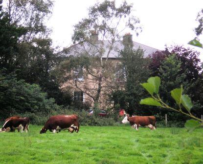
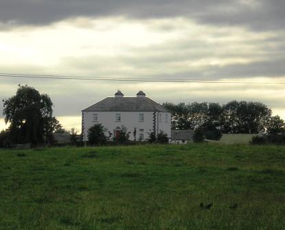
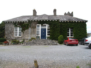
Belle Isle
Houses within 5km of this house
Displaying 18 houses.
Houses within 5km of Belle Isle
Displaying 18 houses.
| House name | Description | |
|---|---|---|
| Portumna | Reverend Lewis Hawkes was leasing a property at Portumna, valued at £16 from the Ecclesiasical Commissioners at the time of Griffith's Valuation. The Reverend Louis Hawkes of Brierfield died in 1857. A house still exists at the site. | |
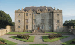
| Portumna Castle | The house we know as Portumna Castle was built in the early seventeenth century by Richard de Burgo or Burke, 4th Earl of Clanricarde. It was used as the de Burgo/Burke family residence for over 200 years until it was badly damaged by fire in 1826 when it was replaced by another house close by. This second house is no longer extant. In 1906 the buildings at Portumna were valued at £40. The original Portumna Castle has been restored and is open to the public. |
|
| Earlstown | In 1786 Wilson refers to "Capasell" s the seat of Mr. Devenish [?]. The house at this location is labelled Earlstown on the 1st edition Ordnance Survey map. In 1846 Slater refers to Robert Grace resident at Earlston. Robert Eyre was leasing a property in the townland of Cappasallagh, parish of Kilmalinogue, barony of Longford, valued at £11 from the Clanricarde estate in 1856. There are still occupied buildings at this site, the focus of a large farming enterprise. |
|
| Derryhivney House/Harding Grove | Wilson may be referring to this property when he mentions the ruins of a castle at "Derryborn" and the seat of Mr. Hind. In 1814 this house was known as Harding Grove and was the seat of Jonathan Harding. It appears under this title on the 1st edition Ordnance Survey map. The Harding family also had an estate in north Tipperary. In 1846 Slater refers to "Derryhiney" as the seat of Cuthbert Fetherston. At the time of Griffith's Valuation, the house at Derryhivney was occupied by him. On the 25-inch map of the 1890s it is labelled Derryhivney House. David England Young of Ballygibbon, county Tipperary and Harding Grove, county Galway is recorded in Walfords (1910). |
|
| Fairy Hill | Thomas Doolan was leasing a property at Fairy Hill, valued at £20, to Charles Cooper at the time of Griffith's Valuation. Slater had noted it as the residence of Thomas Doolan in 1846. In 1894 Slater records Fairy Hill as the seat of Colonel Cheevers. This house is still extant. |
|
| Palmerstown ( Pokoroko) | In 1814 a house at Fairy Hill was the residence of Mr. Palmer. This property was held on a lease renewable forever from the Clanricarde estate. It is recorded in Lewis under Portumna town. In 1865 it was occupied by Lewis Goodbody who had purchased it in the Landed Estates Court in 1861. The sale notice refers to the house as "Pokoroko" and this title appears again in the Cunningham sale report of June 1886. However on both the 1st and 25-inch editions of the Ordnance Survey map it is labelled Palmerstown House, the name by which it is still known. It is still extant and occupied. |
|
| Gortaha House | Cuthbert Featherston held a property valued at £10 in the townland of Gortaha, parish of Lickmolassy, barony of Longford, in 1856. It is labelled Gortaha House on the 1st edition Ordnance Survey Map. The 25-inch map of the 1890s records that it was "in ruins" and very little now remains. | |
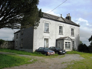
| Willmount or Gortnacloghy | In 1856 Matthew McDonagh was leasing a property valued at £19 in the townland of Gortnacloghy, parish of Lickmolassy, barony of Longford, from the Clanricarde estate. This house was also known as Wilmount or Wellmount. |
|
| Oakley Park | At the time of Griffith's Valuation, John Cunningham was leasing a house valued at £13 at Gowil, parish of Lickmolassy, from Anne Shewbridge. This appears to be the house known as Oakley Park, occupied in the 1870s by the Pigot family. It is still extant and occupied. |
|
| Gortmore | The sale rental states that Robert Biggs built this house for about £800 in the mid 19th century. It is not marked on the first edition Ordnance Survey map. Griffith's Valuation records Samuel Biggs as the occupier of the house, valued at £11 and held from Edward Biggs. The sale rental of November 1867 advertised the sale of a valuable leasehold, the estate of Samuel and Robert Biggs, at Gortmore (222 acres and dwelling house). The 22[2?] acre estate of Samuel Biggs at Gortmore was sold to John Samuel Clarke, the petitioner, in November 1867 for £650 (The Irish law times and solicitors' journal: Volume 1, 1868 - Page 679). A house is still located at this site. | |
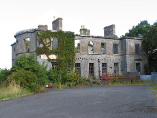
| Firmount | The seat of the Firman family in the late 18th century, occupied by Thomas P. Terman in 1814. The house is marked on the first edition Ordnance Survey map. The Ordnance Survey Name Books refer to it as "the mansion house of Firmount now falling into ruins, It appears to be a ruin by the time of Griffith's Valuation. The only buildings over £10 valuation were the Santa Cruise flour mill and house of Samuel Palmer. The Irish Tourist Association surveyor records "an extremely charming house converted from stabling" at Firmount and occupied by Major H.H. Deasy in the early 1940s. The surveyor states that the original house was destroyed by fire. | |
| Ballyquirk | In 1837 Lewis refers to the ruins of Ballyquirk castle "near which is a handsome modern house of that name". Colonel Henry Dwyer was the occupant in the mid 19th century, holding the house valued at £32 and 716 acres from Edward Newingham. |
|
| Harvest Lodge | The Stoneys were resident at Harvest Lodge from at least 1837. Thomas Johnston Stoney, born 1780, fourth son of Thomas Stoney of Arran Hill held the property in fee at the time of Griffith's Valuation, when the house was valued at £30. Harvest Lodge was the home of J.M. Wilson in the 1870s. This house no longer exists. | |
| Portland Park | A residence of the Stoney family from at least the 1770s, when it was purchased from the Earls of Antrim. Occupied by Richard Stoney in 1814 and by J. Chapman in 1837. In 1841 the Ordnance Survey Name Books described it as "a spacious building, the residence of Thomas B. Stoney with a great demesne". At the time of Griffith's Valuation he held the property in fee when the buildings were valued at £40. Portland Park remained in the possession of the Stoney family until it was burnt in 1936 (Irish Times, 11 May 1936). It is now a ruin. |
|
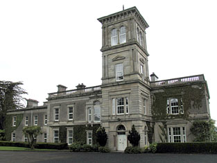
| Slevoir | Lewis records R. Monsell as resident at Slevoir in 1837. The Reverend Francis Synge was the occupier at the time of Griffith's Valuation, holding the property from the representatives of Mr Steele. The buildings were valued at £34. The National Inventory of Architectural Heritage states that the present house was built in the Italianate style in the 1870s for Lieutenant Colonel J.F. Hickey by John McCurdy. In the early 1940s General Carlos J. Hickie was the owner and the house contained very beautiful furnishings and valuable family pictures according to the Irish Tourist Association surveyor. This house sold for over £3 million in 2000 and was offered for sale again in 2011. |
|
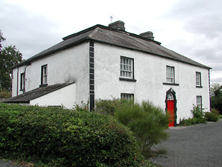
| Ashgrove | Lewis records B. Talbot as resident. In 1840 the Ordnance Survey Name Books record that the house derived its name from "a large ash grove, recently cut away". A house valued at £15+ at the time of Griffith's Valuation when it was occupied by Reverend Benjamin Talbot and held from Sir John Power. Reverend Benjamin was still resident in the 1870s. Ash Grove is still extant. |
|
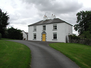
| Shannon View | Close to the shore of Lough Derg, this house is marked on the first edition Ordnance Survey map. In 1840 the Ordnance Survey Name Books refer to it as "a good dwelling house". At the time of Griffith's Valuation it was occupied by Anne Talbot, held from the Reverend Benjamin Talbot and valued at £4.10 shillings. Frances Talbot of Shannonview owned 42 acres in the 1870s. It is still extant. |
|
| Palmerstown Cottage (Lodge) | At the time of Griffith's Valuation, Timothy Joyce was leasing this property from the Palmer estate when it was valued at £5. It is still extant but not currently occupied. |