Milleen
Houses within 5km of this house
Displaying 19 houses.
Houses within 5km of Milleen
Displaying 19 houses.
| House name | Description | |
|---|---|---|
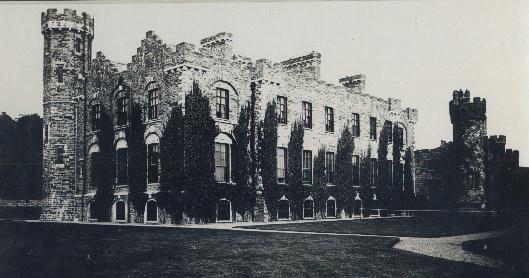
| Castle Freke | At the time of Griffith's Valuation, it was held in fee by Lady Carbery and valued at £90. In 1906 it was held by the trustees of Lord Carbery and valued at £136 . The existing building at Castlefreke was constructed at the end of the eighteenth century, replacing an earlier castle which had belonged to the Barry family, the original owners of the estate. It was modified in the late nineteenth century but subsequently gutted by fire in 1910 and restored by 1913. It was sold by John, 10th Lord Carbery, after WWI. In the early 1940s the Irish Tourist Association survey reported that it was unoccupied but in good repair and owned by the Land Commission. Castlefreke fell into ruin throughout the twentieth century but a portion of it has since been restored |
|
| Rathbarry Vicarage/Rectory | Lady Carbery was leasing Rathbarry Vicarage to Rev. H. Stewart at the time of Griffith's Valuation, when it was valued at £20. Labelled as Rectory on the later 25-inch Ordnance Survey map, it is now known as Rathbarry House. |
|
| Milltown Place | Arthur Aylmer was leasing this property from Lady Carbery at the time of Griffith's Valuation, when it was valued at £17 5s. Aylmer was a younger son of the Aylmer, Donadea, county Kildare, family. His mother was Jane Evans-Freke, a daugher of the 1st Lord Carbery. He was later to succeed to the title of Baron Aylmer. By the 1890s the building at the site has been divided into a school and the Constabulary barracks. A smaller building exists at the site now. | |
| Coppinger's Court | Built by Sir Walter Coppinger in the early seventeenth century and partially destroyed in the 1641 Rebellion. Described by Bence-Jones as an impressive semi-fortified house. By the mid nineteenth century it had fallen into ruin and is not mentioned in Griffith's Valuation, when the lessor of the surrounding land was Lady Carbery's estate. |
|
| Millfield House (Ross) | This house, with a mill valued at £40, was leased by William Limerick to Henry Morrow in 1851, when the house was valued at £12 5s. Lewis notes Millfield as the seat of Lieut. Lloyd, RN, in 1837 while it is noted by Leet as the residence of Roger Sweeny in 1814. The mill is labelled Ross Mill on the 25-inch map of the 1890s. There is still an extant house at the site as well as the remains of some mill buildings. | |
| Cahermore House | In 1851 Thomas Hungerford was leasing Cahermore House from the Bishop of Cork's estate,when it was valued at £32. It was owned by Henry Hungerford in 1906 and valued at over £44. Taylor and Skinner's map of 1783 as well as Wilson in 1786 also mention Cahermore as a Hungerford residence. In 1944 the Irish Tourist Association Survey noted that Cahermore had been burnt during the War of Independence and was then derelict. Donnelly indicates that it was burnt in June 1921. It is no longer extant. | |
| Burgatia House | Leased by Robert Starkey from the estate of the Bishop of Cork at the time of Griffith's Valuation when it was valued at £12. Donnelly indicates that this house was occupied by Thomas Kingston when it was burnt in February 1921 during the War of Independence. It is no longer extant. | |
| Easton House | In 1851 Jane Smyth was leasing this property from the Bishop of Cork's estate when it was valued at £13 15s. | |
| Creggane House | Creggane House was in the possession of John [Lichfield] at the time of Griffith's Valuation when it was valued at almost £9. It was leased to Robert Starkey at the time. A more substantial house is shown on the later 25-inch map of the 1890s. In 1885 Walford described Francis Evans Bennett as of "Creggane". A house is still extant at the site. | |
| Derry House (Ross) | Family records indicate the original house at Derry was bought by Bryan Townsend, son of Richard, the Cromwellian officer, in the 1680s. This house was a short distance from the current house which was built by Reverend Horatio Townsend in the early years of the nineteenth century and was held in fee by Reverend Chambre Townsend in 1851 when it was valued at £44. Earlier, in 1786, Wilson referred to Derry as a Townsend seat. It was substantially damaged when it was burnt in April 1921 during the War of Independence. . At the time it was the residence of Alexander Sullivan, a well-known barrister. In 1944 the Irish Tourist Association Survey noted that it was still derelict following the 1921 burning. The centre portion of the house and a substantial farm still exist at the site. |

|
| Roury House | Occupied by William Bleazby at the time of Griffith's Valuation on lease from the Townsend estate and valued at £12 5s. In 1885 Walford refers to the seat of William J. Bleazby as Bleazby Hall. A house still exists at this site. | |
| Castle Downeen | James Courcey was leasing Castle Downeen from Rev. John Smyth in 1851 when it was valued at £23 10s. Lewis refers to the house as the seat of R. Smith in 1837. Shown as a Smith residence on Taylor and Skinner's 1783 map. In 1944 the Irish Tourist Association Survey refers to "Duneen" as "now a farmer's dwelling". It is now a ruin. | |
| Ross Abbey House (Rosscarbery) | Rev. John Hamilton was leasing this property from Elizabeth Jago at the time of Griffith's Valuation, when it was valued at £12. This house no longer exists. | |
| Cashel House (Kilmacabea) | William Wolfe was leasing this property, then valued at £12, from Miss Wheeler, at the time of Griffith's Valuation. Local records suggest the family were associated with this house since the eighteenth century. The original house is no longer extant and a modern house exists at the site now. | |
| Connonagh House | John Morris was leasing this property to Barbara Jago in 1852 when it was valued at almost £8. There is still an extant house at the site. |
|
| Westwood/Benduff Cottage | Catherine French held this property from William Morris at the time of Griffith's Valuation. On the 25-inch Ordnance Survey map of the 1890s it is labelled Westwood. In 1906 it was owned by Michael French and valued at £13 10s. There is still an extant house at the site. | |
| Castle Salem | This property had formerly belonged to the McCarthys but was acquired by William Morris and re-named Castle Salem. In 1786 Wilson refers to it as the seat of the Morris family but by the publication of the first Ordnance Survey Map it is labelled "Benduff Castle or Castle Salem, in ruins". This property, developed over several centuries, is still extant and occupied. |
|
| Ballynagornagh House | In 1786 Wilson refers to "O'Barley-Hill" as a seat of Mr. Morris. At the time of the publication of the 1st Ordnance Survey the original Ballynagornagh House is described as "in ruins". However, a house has been restored on the site by the 1890s when it appears on the 25-inch Map. At the time of Griffith's Valuation, the townland was still in the possession of the Morris family though much of it was leased to the Donovans. The house was valued at £4 5s. A substantial farm occupies the site now. | |
| Cellmount House | Wilson, writing in 1786, refers to "Selmount House" as a seat of Mr. Morris, three miles from Ross Carbery. This property is labelled "Cellmount House, in ruins" on the 1st edition Ordnance Survey map and there is no trace of it on later maps. |