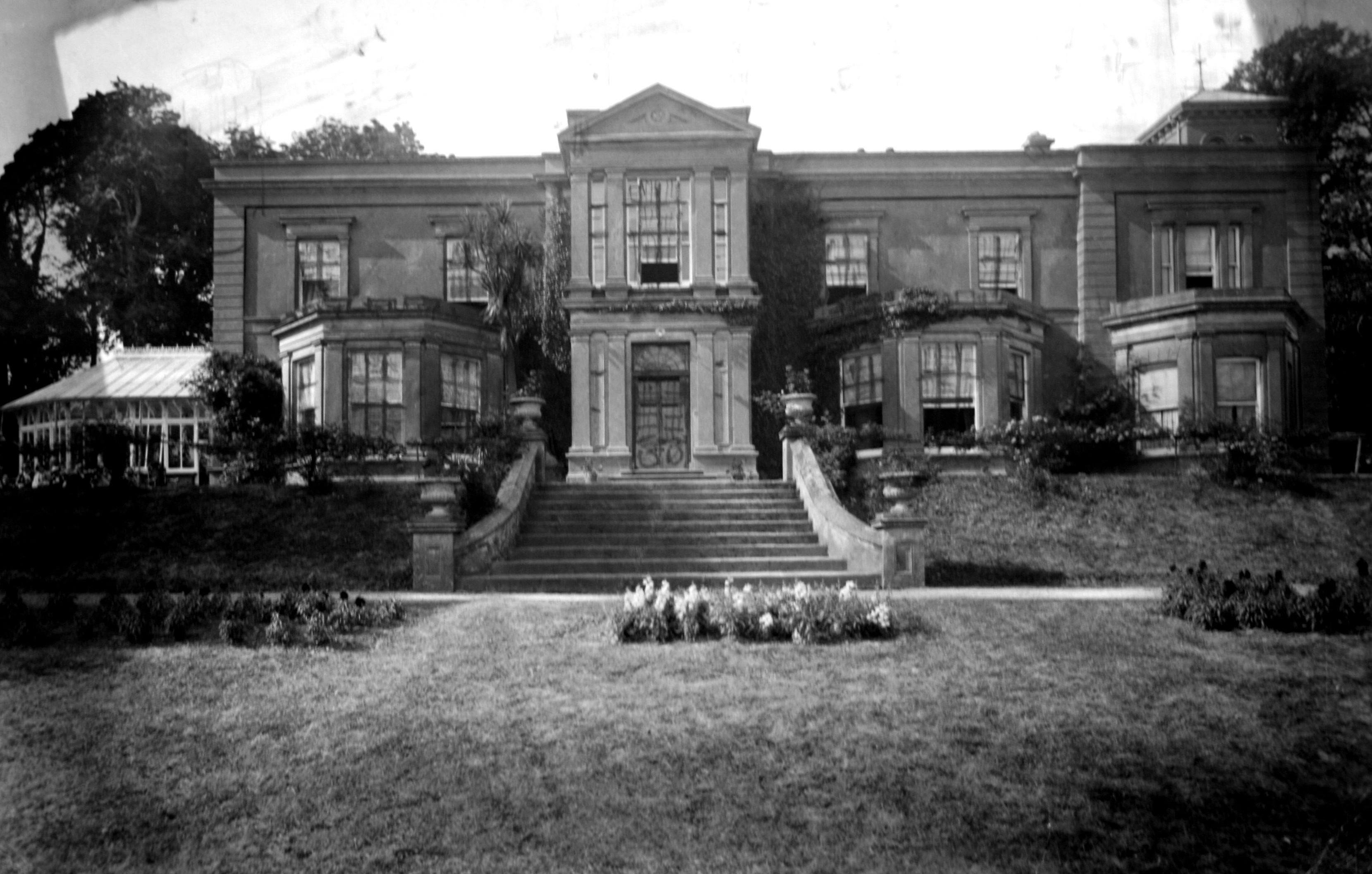
Leamlara
Houses within 10km of this house
Displaying 75 houses.
Houses within 10km of Leamlara
Displaying 75 houses.
| House name | Description | |
|---|---|---|
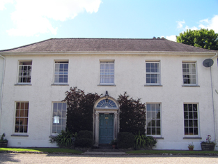
| Fota House | Originally built as a hunting lodge for the Smith Barrys in the 18th century and enlarged in the 1820s to the design of Sir Richard Morrison with further 19th century additions. Valued at £89 and held by James H.S. Barry in fee at the time of Griffith's Valuation. Occupied by Lord Barrymore in 1906 and valued at £160. Inherited by Major and the Honourable Mrs Bell. The Irish Tourist Association survey provides details of some of the paintings in the house and exotic plants in the gardens. Bence Jones writes that Fota was sold to University College, Cork in 1975 following the death of Mrs Bell. It is now in the care of the Irish Heritage Trust and after restoration was reopened to the public in 2009. http://www.fotahouse.com/display.php |

|
| Bishop's Island | Grice Richard Smyth held buildings valued at £25 in the townland of Bishop's Island at the time of Griffith's Valuation. ''Burke's Irish Family Records'' refers to his father Henry Mitchell Smyth of Bishop's Island. In 1786 Wilson notes Bishop's Island as the seat of Mr. Mitchell. | |
| Baneena | John Ross occupied a house at Baneena North valued at £11.10 shillings in the mid 19th century. He held the property from Abraham Devonsher. This house is not surrounded by a demesne on the first Ordnance Survey map. | |
| Mountain Lodge | Originally a shooting lodge of the Devonshers, it was the home of Abraham John Devonsher in the mid 19th century. He held the property valued at £3 in fee. It is now a ruin. | |
| Hollyhill | David Hallahan occupied Holy hill, Rathcormack, in 1814 and S. Croker in 1837. Eliza Croker held the property from Francis C. Reeves in the mid 19th century, when the buildings were valued at £11.10 shillings. [for this Croker family see http://members.iinet.net.au/~nickred/croker_research/The_Irish_CROKER.pdf page 121]. Later the home of the Campion and other families, this house is no longer extant. | |
| Ballyglissane | A Reeves home held from the Devonsher family, occupied by F.G. Reeves in 1837 and by Edward Reeves in the early 1850s when the buildings were valued at £30+. Later the home of the Warren family and still a family residence. |

|
| Mellefontstown | The main residence of the Nason family in the 18th century, John Nason was resident in 1814 and Pierce Cotter in the early 1850s. Cotter held the property from Thomas Wise and the buildings were valued at £19+. In May 1863 Pierce Joseph Cotter's estate at Mellifontstown, containing the house, demesne and 246 acres was advertised for sale. It was held on a lease dated 1852 from Francis Wise to Pierce Cotter for 185 years. A new house now stands on the site. | |
| Scartbarry | Home of the Wilson family in the 19th century, occupied by Edward Wilson in 1814 and by Ellen Wilson in the early 1850s, when the house was valued at £11 and held from James H.S. Barry. Edward Wilson of Scartbarry owned 26 acres in the 1870s. This house is still a family residence. The interest of the descendants of the Wilson family of Scartbarry and of James Milner Barry in the lands of Skehannagh and Coolequane, barony of Barrymore were offered for sale in the 1850s. |

|
| Ballyready | A house located on the Devonsher estate, occupied by Patrick Bourke in 1814. The house was valued at £12.10 shillings and occupied by John Fetnam at the time of Griffith's Valuation. It is still a family home. | |
| Ballycurrany House | This house was occupied by Joseph Wilson at the time of Griffith's Valuation. He held it from James H. Smith Barry and it was valued at £13. It is no longer extant. | |
| Ballynaclashy House | Occupied by Henry Wilson in the early 1850s, held from James H. Smith Barry and valued at £10.10 shillings. Herny Wilson of Ballynaclashy owned 83 acres in the 1870s. A house is still extant at the site. | |
| Glenview | George Courtenay is recorded as resident at Glen-View in 1814 and also in the early 1850s when he held the property from James H. Smith Barry. The buildings were valued at £9. In 2010 it was offered for sale. |
|
| Windsor House | Dominick Sarsfield was living at Windsor, Cork, in 1814 and by 1837 it was the property of J. Martin. Joseph Martin held this house valued at £13.10 shillings from the Earl of Bandon in the early 1850s. Windsor House is still extant and occupied. |

|
| Killahora House | J. Martin is recorded as resident at Killahora in 1837. At the time of Griffith's Valuation John Martin held a house valued at £25 from the Earl of Bandon. A house is still extant at this site. | |
| Union Lodge | This house was the residence of the Reverend William Gifford in 1837. At the time of Griffith's Valuation Hughes Martin was the occupier. He held the property from William Coppinger and the buildings were valued at £21. | |
| Tullagreen | Occupied by Robert Martin in 1814 and by Hughes Martin in 1837. The house was recorded as unoccupied at the time of Griffith's Valuation. Hughes Martin was the immediate lessor and the house was valued at £19+. |

|
| Garrancloyne House | This was the original home of the Coppingers of Middleton. A substantial house with a gate lodge is marked on the first Ordnance Survey map but by the time of Griffith's Valuation the house with the largest valuation in this townland was £2. It was occupied by Hughes Martin and held from William Coppinger.In 1786 Wilson refers to "Killycloyne" as a seat of the Martin family in this area. | |
| Killora Lodge | This house was the residence of Reverend R. Berry [Bury] in 1837 and was unoccupied at the time of Griffith's Valuation. Reverend Robert Bury was the immediate lessor and the buildings were valued at £20. It is still extant and occupied. |

|
| Toureen Lodge/Ashbourne | At the time of Griffith's Valuation the Reverend Robert Bury was occupying a house in this townland valued at £17 and held from the Earl of Bandon. It is labelled Toureen Lodge on the 1st edition Ordnance Survey map and as Ashbourne on the 25-inch edition of the 1890s. In the twentieth century it became famous for its well-known gardens, laid out by Richard H. Beamish. |

|
| Johnstown House | Johnstown was the home of Sarsfield Esq in the 1770s and 1780s. William Martin is recorded as resident at Johnstown in 1814 and Mrs Palmer in 1837. John Courtney occupied the house valued at £21+ in the early 1850s. He held it from the Earl of Bandon. The original house is not extant. | |
| Anngrove | Bence Jones writes that this was originally a Cotter residence, sold to the Earls of Barrymore before the mid 18th century. Dobson Esq was resident in the 1770s and 1780s. By 1814 Francis Wise was resident and was still resident at the time of Griffith's Valuation, when the house was valued at £30 and held from Sir William Clarke. The house was later inherited by the Gubbins family. Demolished post 1950. | |
| Rockville | The Barrys were inhabiting Rockville by the mid 18th century. William Barry was resident in 1814 and his seventh son Thomas Barry in 1837. In the early 1850s Garret Barry was occupying this house which he held from Sir William Clarke. It was valued at £15.15 shillings. | |
| Rossmore | Rossmore was a Coppinger home in the 19th century, the residence of Thomas Coppinger in 1814 and 1837. Thomas Francis Coppinger is recorded as the occupier at the time of Griffith's Valuation when the property, valued at £19, was held from Sir William Clarke. | |
| Barryscourt | Originally a seat of the Barry family, Earls of Barrymore, it had become a Coppinger home by the mid 18th century. Wilson refers to it as the seat of Mr. Coppinger in 1786 and also notes "the castle of Barry's Court". It was the residence of William Coppinger in 1814 and in the early 1850s, when it was held from Sir William Clarke and valued at £22. Following William's death in 1862 this property passed to his nephew Morgan John O'Connell. Bence Jones records it as a ruin but the original medieval castle has been refurbished and is now open to the public. In the 1940s the Irish Tourist Association survey included a description of both buildings. | |
| Sunville | A property held from Francis Wise in the mid 19th century by Thomas Donovan. The buildings were valued at £15.10 shillings. In the 1870s Thomas Donovan of Sunville, Johnstown owned 174 acres in county Cork. | |
| Greenville | Garret Barry, eight son of William Barry of Rockville, occupied this house in the mid 19th century. He held it in fee and it was valued at £17+. He was a racehorse owner and died unmarried. Greenville passed to his nephew Dr William Barry of Rockville and Greenville. Lucy K. Barry was resident in 1906 when the buildings were valued at £34. | |
| Barry's Lodge | Occupied by D. Barry in 1837 and by Henry Barry in the early 1850s. He held the property valued at £28 from Samuel Reeves. | |
| Dundullerick House | Occupied by J[ames] Barry in 1837 and by his son William Barry in the early 1850s. The property was held in fee with 353 acres and the buildings were valued at £26+. William's nephew James William Creagh Barry later purchased Dundullerick. | |
| Dundullerick | This house was occupied by Edmund Barry in the mid 19th century, when it was valued at £16+ and held in fee. Edmond married in 1836 Sarah Isabella daughter of Pierce Creagh of Rockforest Lodge. Their grandson sold Dundullerick to his cousin James William Creagh who took the additional name of Barry. This house appears to have remained in Creagh Barry possession until the 20th century. \in 1906 valued at £19.10 shillings and occupied by Pierce Barry. | |
| Cloneen | Leet records - Hoare esq as resident at Cloneen, Middleton, in 1814. In the mid 19th century Robert Lunham held a house valued at £20+ from Bingham Sarsfield in this townland. Sarsfield held the property from Abraham Devonsher. When Cloneen was advertised for sale in 1870 it was occupied by Joseph Sheedy. Bingham Sarsfield of Cork owned 266 acres in county Cork in the 1870s. A house is still extant at the site. | |
| Curragh | At the time of Griffith's Valuation John Courtenay held a house, offices and gate lodges at Curragh, valued at £28. The first Ordnance Survey map shows a farm yard for Ballyedmond in Curragh. The 25-inch map of the 1890s still indicates extensive farm buildings, together with kennels. Farm buildings remain at the site. | |
| Ballyedmond | Ballyedmond passed through marriage from the Brownes to the Courtenays. Robert Courtney was the proprietor of Ballyedmund in 1814. John Courtenay held Ballyedmond from the Reverend William Halloran in the mid 19th century. The buildings were valued at £199. The seat of Robert Courtney Smith-Barry in 1894. Inherited by the Smith Barrys and sold by them in the 1960s. The house no longer exists but much estate architecture including gate lodges survives. |
|
| Springhill | This house was a Wakeham home from at least the mid 1770s. William Wakeman was resident at Springhill in 1814 and W.J. Wakeham in 1837. Joseph B. Wakeham held Springhill in fee at the time of Griffith's Valuation when the buildings were valued at £15+. | |
| Ballyvodock | Thomas Wigmore occupied this house in the mid 19th century. He held it from the representatives of Viscount Midleton and it was valued at £9+. | |
| Young Grove | Mrs Foulke was resident in 1814 and C. Foulke in 1837. At the time of Griffith's Valuation John Turpin held the property in fee and the buildings were valued at £50. Margaret T. Turpin was resident in 1906 when the buildings were valued at £45.10 shillings. | |
| Roxborough | Wilson, writing in 1786, refers to "Rocksborough" as the seat of Mr. Ball. The residence of Bent Ball in 1814 and of - McSweeny in 1837, this house was unoccupied in the early 1850s when it was valued at £22. The immediate lessor was Sir A. Brooke. The house has disappeared by the time the 25-inch Ordnance Survey map was published in the 1890s and the Youghal branch of the Great Southern & Western railway constructed close by. | |
| Ballyvodock House | James Barry was living at Ballyvodig House, Middleton, in 1814. In the mid 19th century William Kelleher was the occupier. He held the property from William Oliver Jackson and the buildings were valued at £11. A house and large farm are still extant at the site. | |
| Ballintubbrid House | Ballintobrid, Middleton, was the home of William Weekes in 1814. By 1837 it was the home of the Heard family and occupied and held by Edward Heard in fee at the time of Griffith's Valuation. The house was valued at £13. The original house is not extant. | |
| Ballyannan | The Brodricks first occupied Ballyannan Castle, a fortified house in the townland of that name, which was in ruins by 1837. In 1786 Wilson refers to Ballyanan"belonging to Lord Viscount Midleton". On the first Ordnance Survey map there is a building named Ballyannan House (W867 715) right on the shore close to the castle and there is a house in the townland of Garryduff named Ballyannan. Ballyannan was occupied by Roger Adams in 1814 and by J. Adams in 1837. At the time of Griffith's Valuation the representatives of Viscount Midleton occupied a house and offices valued at £19 in the townland of Garryduff. The house in the townland of Ballyannan was valued at £9.10 shillings and was occupied by Daniel Twomey and held from the Viscount. | |
| Caherduggan | In 1786, Wilson refers to "Carduggan" as the seat of Mr. Davis. Denis O'Callaghan was living at Cadogan (Caherduggan) by 1837. He held the property in fee at the time of Griffith's Valuation when it was valued at £48. This house remained in the possession of the O'Callaghan family until the 20th century. It is still extant but unoccupied. |

|
| Ballytrasna House | No house with demesne is marked on the first Ordnance Survey map in this townland but by the time of Griffith's Valuation Timothy O'Regan was occupying a house and other buildings valued at £19+ which he held from John Courtenay. Farm buildings are still extant at this site. A property labelled Ballytrasna House is shown on the 25-inch map of the 1890s, located in the next townland of Glenawillin [W876796]. This property was also being leased by O'Regan from the Courtenay estate at the time of Griffith's Valuation, when it was valued at £5+. However, it had become a more substantial property by the 1890s. A house is still extant at the site. | |
| Leadinton | The home of the Atkin family for most of the 18th and 19th centuries. In 1786 Wilson refers to it as the seat of Mr. "Arkin". Valued at £16.15 shillings at the time of Griffith's Valuation, it was occupied by the Reverend Joseph Wright and held from J.T. Atkins Swanne. | |
| Brooklodge House | A house and paper mill valued at £30 held by Mary Eliza Phair from the Reverend Robert Bury at the time of Griffith's Valuation. This Phair family were involved in paper mills in a number of townlands in this locality. | |
| Brookville | Home of Cornelius O'Callaghan who held it from the Reverend Robert Bury in the mid 19th century. The buildings were valued at £35. |

|
| Blossomgrove | Blossomgrove was the residence of William Casey in the early 1850s. He held the house valued at £22 and 335 acres from Simon Dring. A house is still extant at the site. | |
| Butlerstown | Nathaniel C. Martin held a house, offices, foreman's house and spade factory valued at £25 from Francis Beamish. The property is labelled Butlerstown House on the 25-inch Ordnance Survey map of the 1890s when the spade factory is no longer visible. There is still an extant house at the site. | |
| Corbally | ''Burke's Irish Family Records'' describes the Sheehys of Corbally House from about the late 18th century. In the mid 19th century the house was occupied by William J. Sheehy, second son of Bryan Sheehy of Corbally House, died 1806. The buildings were valued at £27 and the property was held from the Reverend Edward Newenham. This house was named 'Mill View' on the first Ordnance Survey map. Mill View was still occupied by Sheehys when it was advertised for sale in 1871. | |
| Maryborough | The sale rental for the Mannix estate states that this house was built in 1816 at a cost of £3,000. Occupied by J. Wallis in 1837 and by Henry Mannix in the early 1850s. Mannix held the property from the representatives of the Reverend Robert Dring and the buildings were valued at £28. |

|
| Rockgrove | The seat of the Dring family in the 18th and 19th centuries, valued at £50 in the early 1850s. Bence Jones writes that it was sold by the Drings in the early 20th century, valued at £80 in 1906, and was restored in the 1970s. The house is now used as offices. |
|
| Riverstown | An early 18th century house with fine plasterwork by the Francini brothers, the seat of the Browne family for two and a half centuries. The Brownes were still occupying the house in 1837 but John Carmichael is recorded as the occupier in the early 1850s when it was valued at £32.10 shillings. Restored in the 1960s by the Dooleys with help from the Irish Georgian Society. |
|
| Glyntown House | Unoccupied in the early 1850s, this house was held by Eliza McCaul from William B. Hoare. It was valued at £35. Bence Jones writes that this house, now demolished, was built by Samuel McCall and was owned in the 20th century by the Dring family. | |
| Ballinglanna | Occupied by J. Newsom in 1814 and E. Newsom in 1837. Edward Newsom held this house from Eliza McCaul and Louis Denay at the time of Griffith's Valuation when it was valued at £24. This house is named Glenville on the first Ordnance Survey map. |

|
| Kilcoolishal | Thomas Martin occupied a house valued at £18+ in this townland at the time of Griffith's Valuation. He held it from W. B. Hoare. | |
| Glenburn | Glenburn was occupied by A. Lewis in 1837 and was held in fee by John T.C. Gibbings at the time of Griffith's Valuation. The buildings were valued at £20.15 shilllings. |

|
| Annmount | In the 1770s Falkiner Bart was resident and in 1786 Wilson refers to Annemount as the seat of Sir Riggs Falkiner. Occupied by the Reverend Mr Coghlan in 1814 and in 1837. By the time of Griffith's Valuation Nicholas M. Cummins held this house from the Reverend Coghlan. This house was burned down and all that now remains are the steps. |
|
| Ashton Grove | This house is marked Ashton Grove on the first Ordnance Surve map. John Cotter was the proprietor of Ashton, Cork, in 1814 and T. Cleary of Ballingohig in 1837. Thomas J. Cleary held the property from Henry Braddell at the time of Griffith's Valuation when the buildings were valued at £22. Cleary held a cornmill from Braddell in the townland of Kilrussane. James Fitzgerald held 122 acres of untenanted land and buildings valued at £26+ in 1906. |
|
| Mitchellsfort/Fellfort | This house was the home of Mitchell Esq in the 1770s and 1780s. Occupied by Brooke Brazier in 1814 and by his son Henry B. Mitchell in the early 1850s. Henry B. Mitchell owned the property in fee and the buildings were valued at £52+. Slater noted it as the residence of R.L. Fell in 1894, now demolished. | |
| Rock Farm | The home of John Cantillon in 1837 and in the early 1850s when it was valued at £16 and held from Warren Hastings Rowland Jackson. | |
| Carrigrenan | Occupied by J. M. Ashlin (father of the architect George Ashlin) in 1837 and by the Reverend Robert Bury in the early 1850s. He held the house valued at £37 from Warren H. R. Jackson. The home of the Sullivans in the 20th century. | |
| Castleview | A Jackson property which was unoccupied in 1837. By the time of Griffith's Valuation Robert Delacour Beamish was resident in the house valued at £34 which he held from the Jacksons. The house was sometimes known as Ditchley House. Now functions as the Radisson Hotel, Little Island. |

|
| Hermitage | A house valued at £18, occupied by Eliza Martin and held from Robert Webb at the time of Griffith's Valuation. In the 20th century the home of Edmund Glen Browne. |

|
| Wood View | The home of J. Cremen in 1837 and Jeremiah Crimmin in the early 1850s, when the house was valued at £16 and held from Thomas Wyse. | |
| Sarsfieldscourt [Old] | In 1837 Lewis refers to Sarsfieldscourt as an ancient mansion "formerly belonging to the Sarsfield family but now to Mr Rutland [Putland] of Dublin". On the first Ordnance Survey map one building is marked as "in ruins". Another building also named Sarsfield's Court is marked closer to the Glashaboy River. At the time of Griffith's Valuation Charles Putland junior was recorded as occupier, holding the house valued at £13 from his father Charles Putland. This latter property is labelled Beechmount on the 25-inch Ordnance Survey map of the 1890s. A property labelled Sarsfieldcourt House is also located in the townland on the later map [W723779]. It is no longer extant and St.Stephen's Hospital now occupies the grounds. | |
| Ballynacorra | An 18th century house, occupied by John Garde in 1814 and by Thomas Garde at the time of Griffith's Valuation, who held the building valued at £40 from the Earl of Shannon. Still in use as a residence. | |
| Broomfield | A home of the Garde family in the second half of the 18th century. The residence of D. Humphreys in 1837 and of William Humphreys in the early 1850s. At this time the house was valued at £30 and held from the representatives of Viscount Midleton. This house is still in use as a residence. |
|
| Lakeview | Located on the southern outskirts of Midleton town, Swithin Fleming is recorded as the occupier of this house on the Midleton estate and 12 acres from at least 1837 until the 1870s. In the mid 19th century it was valued at £14. | |
| Killeagh | A house on the Midleton estate occupied by W. Welland in 1837 and Henry Welland at the time of Griffith's Valuation. He held the house valued at £40 with 427 acres. William Welland of Brooklodge, Middleton, owned 185 acres in the 1870s. This house now known as Westpark House is still a family residence. |
|
| Cahermone | Wilson, writing in 1786, refers to Cahermone as the seat of Charles Broderick. The house was the residence of Thomas Poole in 1814 and in 1837. Lewis states that Poole was agent to the Midleton estates. Laurence Smithwick occupied the house at the time of Griffith's Valuation when it was valued at £8. Though buildings there were vallued at £19 in 1906 the original house is not shown on the 25-inch Ordance Survey map of the 1890s. Farm buildings occupy the site now. | |
| Condonstown | Timothy Mahony occupied a house valued at £6 which he held with 165 acres at Condonstown North from J.H.S. Barry in the mid 19th century. By 1906 the buildings were valued at £15+ and Arthur H.S. Barry is given as the occupier. Grid reference is approximate. | |
| Trantstown | A Trant home in the 18th century, occupied by Mrs Pepper in 1837 and by James Barry in the early 1850s. He held the house valued at £8+ from Lady A.H. Fitzgerald. Buildings are still located at this site. | |
| Ballynaroon | Griffith's Valuation records a house valued at £13.15 shillings in this townland in the mid 19th century. It was occupied by Charles W. Welland and held from the representatives of Viscount Midleton. The house is named The Highlands on the 25 inch to the mile map. Only yard buildings now remain at this site. | |
| Corbally South | Catherine Delany held buildings valued at £11 from William J. Sheehy in Corbally South at the time of Griffith's Valuation, with 148 acres. Buildings are still located at this site. | |
| Ballinderrig | Ballinderrig is marked on the first edition Ordnance Survey map and was occupied in the mid 19th century by Jane Cantillon. She held the property valued at £13+ from Eliza Bury. Catherine Cantillon was also resident in the townland at Courtstown Cottage Grid Ref W774 720. By the publication of the 25-inch Ordnance Survey map in the 1890s the latter property has become known as Courtstown House. It is still extant. | |
| Hunting Fort | A house valued at £10 occupied by Patrick Keneiry and held by him with 338 acres from the Duke of Devonshire in the mid 19th century. A building is still extant at this site. | |
| Peafield (Templemodan) | In 1786 Wilson refers to Peafield as the seat of Archdeacon Mockler. There is no substantial house shown in this area on the 1st edition Ordnance Survey map. By the time of Griffith's Valuation, the townland was in the possession of Thomas Boyce. |