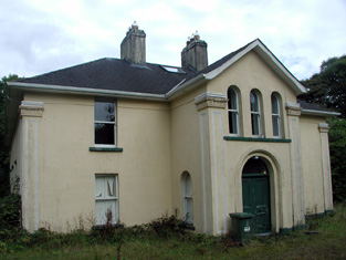
Rooaun Lodge
Houses within 10km of this house
Displaying 26 houses.
Houses within 10km of Rooaun Lodge
Displaying 26 houses.
| House name | Description | |
|---|---|---|
| Derrycarne | At the time of Griffith's Valuation Derrycarne was the property of William Ormsby Gore and was valued at £30. Lewis records it as the seat of the Nisbett family in 1837. In 1906 it was in the possession of Lord Harlech (Ormsby Gore) and was valued at £33. The Ormsby Gore estate was eventually sold in 1924 and Derrycarne and about 80 acres were acquired by a Col. Kirkwood, a relative of the Kirkwood family of Woodbrook, county Roscommon. It changed hands again several times before being acquired by the Land Commission in 1952. The house was demolished shortly afterwards. | |
| Aughry House | Aughry House built after the publication of the First Edition Ordnance Survey map. At the time of Griffith's Valuation it was owned and occupied by Charles T. Ward and was valued at £13. Aughry Castle (in ruins) is visible nearby on the 1st edition map. This may be the property referred to in 1786 by Wilson as the seat of Mr. Nesbit. Elaborate modern entrance gates identify Aughry House which appears to be close to the site of the original. | |
| Aghamore House | Russell B. Cameron was leasing this property from the Crofton estate at the time of Griffith's Valuation when it was valued at £12. A house is still extant though not on the original site. | |
| Georgia | At the time of Griffith's Valuation, the Forbes estate was leasing a house valued at £6 to Andrew McCloughesy at Georgia or Gorteenoran. The premises is visible on the early 20th century maps but the site is now occupied by a hotel complex. | |
| Kilmore House | Built by the Reverend Edward King, Bishop of Elphin circa 1630. Home of a branch of the Lawder family in the 18th century until the murder of James Lawder in 1779. The Auchmuty family resided at Kilmore in the 19th century. The demesne was named Aghaward on the first Ordnance Survey map. A large farm is still extant at the site. | |
| Gillstown | The residence of Mr John Stafford in 1749 and of J. Hogg in 1837. Occupied by Thomas Cox in the second half of the 19th century, who held the property from John Blakeney. Valued at £5 in the 1850s. In 1906 the buildings at Gillstown were valued at £8.10s and were occupied by the representatives of Thomas Cox. | |
| Ballycummin | A house valued at £8 when occupied by Roderick J. Hanley, who held it from Laurence Murray, at the time of Griffith's Valuation. Described by Lewis in 1837 as the former seat of the Earl of Roscommon and at that time occupied by Lieutenant Rodrick J. Hanly. | |
| Ashfort House | The home of John Lawder in 1814. Occupied by Hubert K. Waldron in 1837. At the time of Griffith's Valuation occupied by John Hamilton and held from Thomas Goff. Farm buildings exist at the site now. There was a second smaller house known as Ashfort Vale in the same demesne grounds. It is no longer extant. | |
| Tully Lodge | Built circa 1820, occupied by J. W. Kelly in 1837 and by Christopher Lawder in the 1850s who held the property in fee. It was valued at £20. Occupied by Samuel Russell in 1906. Another house marked as Lakeview was in the demesne grounds at the time of the first Ordnance Survey. In 1837 W. McDonnell was residing in Lakeview [M987 921] |
|
| Sallyfield | A Hanly home from at least 1749 but by the 1850s held by George Lawder in fee. It was described at this time as a steward's house with offices and a lodge, valued at £3. It is labelled on both the 1st and 25-inch edition Ordnance Survey Maps as Sallyfield. It is no longer extant. A house named Cottage was also in the townland of Lavagh at N005 895 on both maps. | |
| Mount Dillon | Lewis writes that the house was situated on an isolated hill and formed "a conspicuous object in the surrounding scenery". Valued at £15 in the mid 19th century. Wilson, in 1786, refers to it as the seat of Mr. Dillon. In the possession of Samuel Russell in 1906 when the buildings were valued at £3. It is no longer extant. | |
| Cloonfree | The residence of William Mahon. Apparently the residence of George Knox in the 1840s. http://www.ballykilcline.com/story_f.html | |
| Cloonahee | Residence of Gilbert Conry in 1814 and of John Conroy esq in 1822. According to a note with the sale rental of 1853 the house was accidently burnt and a good farm house built as a replacement. The home of John Heague in the mid 19th century. Occupied by Richard Hague and valued at £40 in 1906. |
|
| Castlenode House | Residence of Thomas Morton esq in 1822 and of J. Morton in 1837. In the mid 1850s, George Walpole was the occupant of this house, which he held from the Pakenham Mahon estate when it was valued at £8. A house still occupies the site of the original Castlenode House. | |
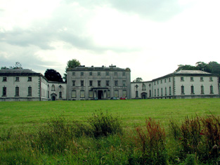
| Strokestown House | Late 17th century house altered in the early 19th century and home of the Mahon family for three centuries. In 1786 Wilson described it as "fine mansion house with ample and beautiful demesne". Referred to as "Bawn House", the mansion of Lord Hartland, by Lewis in 1837. Valued at £70 in the mid 19th century. Now a major tourist attraction containing the Famine Museum. http://www.strokestownpark.ie/ |
|
| Newtown Glebe | Newtown Lodge was occupied by Anthony Dignam in 1814 and the Glebe House at Newtown, valued at £18, was occupied by Reverend Joseph Morton at the time of Griffith's Valuation. It was leased from the Pakenham-Mahon estate. It is still extant. | |
| Cloonfinlough Lodge | Occupied by Robert Devenish at the time of Griffith's Valuation, who held the property from John Caulfeild. Buildings are still extant at the site. | |
| Mount Browne | At the time of Griffith's Valuation occupied by George Browne who held the property from James G.Plunkett, valued at £25. The sale rental of the Gunning Plunkett estate in June 1857 states that Mount Browne was held by a fee farm grant from Jane Plunkett, mother and guardian of the owner, to George Browne, dated 30 Oct 1852. Occupied by the representatives of Arthur Browne in 1894 and 1906. | |
| Creta | Occupied by George Harken in 1814 and Daniel Hughes in the mid 1850s and valued at £8. Creta Cottage was occupied by Captain Dillon in 1837. A house is still extant at the site. | |
| Toberpatrick | Originally a Wynne property, occupied by Mulloy McDermott in 1837. In the 1830s the townland is recorded as including the ruins of Clooncaface House. The residence of Alonzo Lawder in the mid 19th century, held in fee and valued at £20. Occupied by B. F. McDonnell in 1906. A later house is extant at the site now. | |
| Moss Hill | Occupied by Peter Conry in 1814 and by Captain Conry in 1837. | |
| Lisroyne Lodge | A house on the outskirts of Strokestown, part of the Strokestown House demesne, valued at £10 at the time of Griffith's Valuation and occupied by Michael Flynn. Some buildings are still extant at the site. | |
| Drumod More | At the time of Griffith's Valuation, Catherine Warren was leasing a house valued at £9 to Francis Murphy at Drumod More, barony of Mohill. Extensive redevelopment and road building have taken place in this area though there are still buildings at the site. | |
| Cloonagh Lodge | An extensive complex of mills is shown at this location on the 1st edition Ordnance Survey map of 1840, including two flour mills. At the time of Griffith's Valuation, Matthias McDonnell was leasing mill properties, valued at £67, from the estate of the Marquis of Sligo. In addition he was leasing a house valued at £4. Cloonagh Lodge is shown on the 25-inch Ordnance Survey map of the 1890s. A house is still extant at the site. . | |
| Curraghroe | At the time of Griffith's Valuation this property was in use as a Constabulary Barracks, valued at £5 and leased from the estate of Theobald Dillon. Local sources suggest the police were withdrawn from the barracks in the late 1860s. In modern times it has become known as Sullivan's Cross. The house is still extant and occupied and in 2014 was offered for sale. | |
| Fair View (Longford) | Jeremiah Gibson was leasing this property from the Gunning estate at the time of Griffiths Valuation in the mid-1850s, when it was valued at over £18. A later house possibly exists at the site now. |