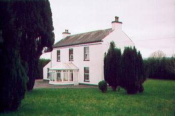
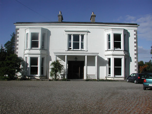
Meelick
Houses within 5km of this house
Displaying 10 houses.
Houses within 5km of Meelick
Displaying 10 houses.
| House name | Description | |
|---|---|---|
| Tintrim | Up to 1898 this house was in the barony of Leitrim, county Galway. It is now in the barony of Tulla Upper, county Clare. At the time of Griffith's Valuation, John A. Burke was occuping the house valued at £11, at Tintrim, parish of Clonrush, barony of Leitrim, county Galway. Weir states that the house at Tintrim was probably built by John Anthony Burke of Clondegoff Castle nearby. He was most likely a member of the Burke family who lived at Meelick House, Whitegate at the same time. Tintrim continued in the possession of the Burke family as John Anthony Burke moved out to allow his son, Edmund, and his family to live there until the house was sold in 1867. The house later passed to the Madden family and is still extant and occupied. The Irish Tourist Association file records state that John A. Burke died in 1857 though the family history suggests he died in 1863. The Tourist Association file also notes that in 1933 there was a search for the heirs of his reputed son, Martin Edward Burke, in Australia. |
|
| Drummaan | Drummaan House is described as "in ruins" on the 1st edition of the Ordnance Survey. The ruins have disappeared by the later 25-inch map of the 1890s. This townland is now located in county Clare. | |
| Knockbrack | At the time of Griffith's Valuation, Joshua Seward was leasing a house valued at almost £10 at Drummaan East, barony of Leitrim. Since 1898 this house has been located in county Clare. This seems to be the house shown on the 1st edition OS map as Knockbrack. A house valued at £14 at Drummaan East, county Clare, was owned by Maj. Gen. Spencer Cooper in 1906. | |
| Gweeneeny | John Sheehy was occupying a property valued at £8 at Gweeneeny, barony of Leitrim, county Galway at the time of Griffith's Valuation. This property has been located in county Clare since 1898. | |
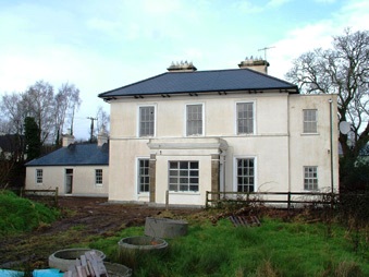
| Mountshannon | This house was located in county Galway until 1898. Weir states that the original house at Mountshannon was a single-storey building which was enlarged to two storeys in the nineteenth century. At the time of Griffith's Valuation it was occupied by Mary Tandy and was valued at £12. In 1906 it was the property of James Wakely and was valued at £17. The house was damaged by fire in June 1921. It later came into the possession of the Talbots of Malahaide who presented it to An Óige (IYHA) for use as a youth hostel in 1956. It was offered for sale in 2007. |
|
| Williamstown Hotel | Joshua Seward was leasing a building valued at £7 to the City of Dublin Steam Packet company at Drummaan East, barony of Leitrim, county Galway, at the time of Griffith's Valuation. This building functioned as the Williamstown Hotel. The original hotel building is no longer extant but the stable block remains and is used as a house. Following 1898 boundary revisions this property is now located in county Clare. |
|
| Williamstadt House | Previously the residence of the Brady family, Williamstadt passed to Dr.Francis Sampson through marriage in 1833. At the time of Griffith's Valuation it was valued at £10 and Sampson was leasing it from James Egan. Up to 1898 this house would have been in county Galway. The house is still extant and occupied. |
|
| Moneenroe/Drummaan House | At the time of Griffith's Valuation Anthony Holland was leasing a property valued at £6 from James Egan, at Drummaan East, barony of Leitrim, county Galway. This seems to correspond to the property labelled Moneenroe on the 1st edition OS map. Other members of the Holland family were leasing lands from Egan in the same townland. On the 25-inch Ordnance Survey map of the 1890s this house is labelled Drummaan, the previous house of that name having disappeared. There is still an extant house at this site which is now located in county Clare. | |
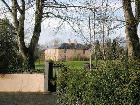
| Castlelough | A circa 1820s house attached to an earlier building on the shore of Lough Derg, Castlelough was the seat of the Parker family. In 1786 Wilson refers to Castlelough and Castletown as seats of the Parker family. Occupied by Anthony Parker in 1814 and in 1837 who was succeeded in that year by his brother the Reverend Standish Grady Parker. The representaives of the Reverend Standish occupied the house at the time of Griffith's Valuation when the buildings were valued at £51+ and held in fee. The Parkers were still resident at the end of the 19th century. This house is still in use as a country residence. |
|
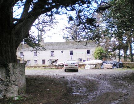
| Garrykennedy | In 1786 Wilson refers to Garry-Kennedy as the seat of Mr. Watson. Lewis refers to the houses of G. Watson and - Kent at Garrykennedy. Two houses are marked in the townland on the first edition Ordnance Survey map Garrykennedy and Shannon ville. The Ordnance Survey Name Books describe Garrykennedy as "a good dwelling house, the residence of James Watson". It was bought by William Parker in 1857. By 1906 a mansion house valued at £25+ was located at Garrykennedy. It was occupied by Robert G. Parker. The building known as Garrykennedy House had been expanded and is marked on later maps. |