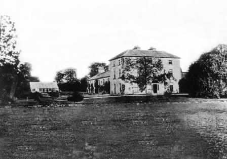
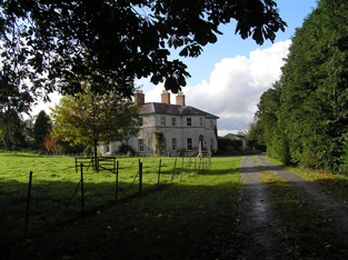
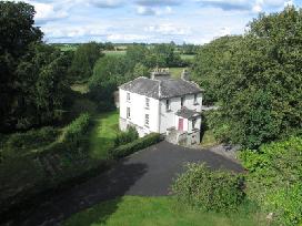
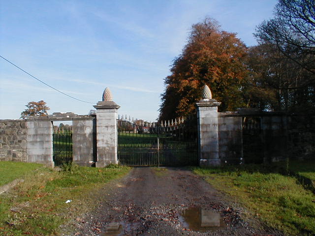
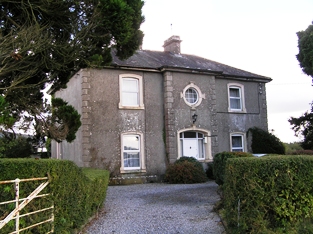
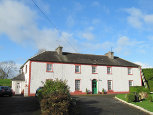
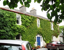
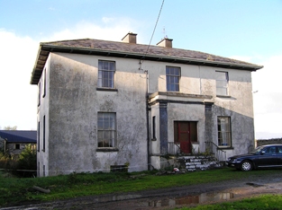
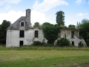
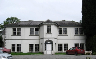
Abbeyland House
Houses within 10km of this house
Displaying 52 houses.
Houses within 10km of Abbeyland House
Displaying 52 houses.
| House name | Description | |
|---|---|---|
| Grange | The Earl of Huntington's estate in Galway included a house valued at £7 at Grange, parish of Killeenadeema, leased to Patrick Murphy. A house labelled Grange House appears on the 1st edition Ordnance Survey map. On the 25-inch edition of the1890s the original house is not shown and Grange House is located at M878146. This house is now a ruin. | |
| Somerset House | At the time of Griffith's Valuation, Thomas Stratford Eyre was leasing a house valued at £20 to William Seymour. Slater refers to the house as the residence of Thomas Craddock in 1894. In 1906 the property at Somerset was held by Charles Seymour. The original house is not extant but there are extensive remains of estate architecture. |
|
| Tully | Joseph Cowan leased lands and a house valued at £7 at Tully to Matthew Madden in 1856. In 1906 Tully was the property of Stephen Cowan and still valued at £7. It is still extant and occupied. |
|
| Cappaluane Glebe | Rev. Richard Eyre was leasing the Glebe house at Cappaluane, barony of Longford, from the Ecclesiastical Commissioners at the time of Griffith's Valuation when it was valued at £18. He was also leasing land from John Eyre. Cappaluane Glebe is still extant and occupied. In 2006 it was offered for sale. |
|
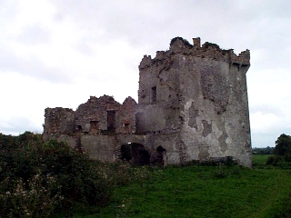
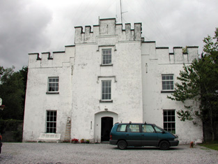
| Eyrecourt Castle | Eyrecourt Castle was originally built in the 1660s. In 1786 Wilson refers to it as "the fine seat of Lord Eyre, with ample demesnes". It is mentioned as a gentleman's seat in the Ordnance Survey Name Books in the 1830s. It was held in fee by John Eyre at the time of Griffith's Valuation when it was valued at £48. A fine lithograph of the Castle appears in the Encumbered Estates schedule when the estate was offered for sale in June 1854. The castle itself is now in ruins. The fine oak staircase is now in the Detroit Institute of Arts. Substantial evidence of the demesne still remains. |
|
| Fearmore House | In 1856 Edward Horsman was leasing a house in the townland of Fearmore from the Clanricarde estate. It was valued at almost £9 at the time. It is still extant and occupied. |
|
| Redmounthill Farm | At the time of Griffith's Valuation the property at Ballynamudagh, a steward's house and out buildings valued at £14, were part of the Pollok estate. In 1906 this property was valued at £41. On the 25-inch Ordnance Survey map of the 1890s the buildings are labelled Redmounthill Farm. The house and some portions of the farm buildings remain at the site. |

|
| Woodview | In the 1830s a "gentleman's residence" named Woodview already existed here. Slater notes it as the seat of Richard G. Daly in 1846. At the time of Griffith's Valuation Richard Eyre was leasing this property from Richard G. Daly. By 1906 this house had become part of the Pollok estate and was valued at £10. The house is still extant and occupied. |

|
| Woburn | A "gentleman's seat" called Waburn is recorded here in the Ordnance Survey Name Books of the 1830s. Slater refers to Woburn as the seat of Henry Flanagan in 1846. Buildings in this townland valued at £15 were leased by Henry Flanagan from the Clanricarde estate in 1856. Woburn is still extant though disused. |
|
| Moorfield House | In 1778and 1786, this house was the residence of the Blake family. Moorfield was a steward's house on the Eyre estate at the time of Griffith's Valuation. In April 1869 the Eyre's Moorfield estate, including the house, was offered for sale in the Landed Estates court. In 1906 it was owned by James Howard Jnr and was valued at £28. The National Inventory of Architectural Heritage suggests that the extant house at Moorfield is of late nineteenth century date. |
|
| Prospect (Meelick) | In 1856 Joseph Cowan was leasing a property at Prospect, in the parish of Meelick, barony of Longford, from Francis Usher. In 1837 Lewis recorded Prospect as the seat of C.A. O'Malley. Slater refers to it as the seat of John Smith in 1846. In 1906 Prospect was the property of Ernest Kenny and valued at £12. In 1778 and 1786, this property was the residence of the French family. Prospect House is still extant and occupied. |
|
| Kilquain | At the time of Griffith's Valuation Allen Pollok held a property in Kilquain valued at £5 10s which was used as a steward's house. There is evidence of estate architecture in the vicinity but twentieth century buildings on site. | |
| Raheen | At the time of Griffith's Valuation, Clifford Trotter was leasing a property valued at £7 along with 284 acres to James Lynam. This property is still extant and occupied. |
|
| Ormond View | The representatives of Redmond Dolphin were leasing a property at Ballycrossaun, barony of Longford, to John D. Lemon at the time of Griffith's Valuation when it was valued at £12. Slater notes this property as the seat of Joseph Lemon in 1846. Hogan states that this house was formerly known as Waterview. Ormond View is still extant and occupied. |
|
| Longford Lodge | In 1846 Slater refers to Patrick and Stephen Kelly, both of "Longford House". Patrick Kelly was occupying the house at Gortadullisk, barony of Longford at the time of Griffith's Valuation. In 1837 Lewis had recorded Longford Lodge as the home of a Major Kelly. In 1906 it was owned by Denis Kelly and was valued at almost £15. It is no longer extant though part of the walled garden remains. |
|
| Greenfield/ Fahy | In 1777 a house at Fahy is recorded by Taylor and Skinner as a Hamilton residence. In 1786 Wilson mentions Faghy as the seat of Mr. Hamilton. Lewis records Fahy as the seat of T. Burke in 1837. The OS Name Books state that the gentleman's residence in the townland of Fahy was called Greenfield. At the time of Griffith's Valuation, Pierce Joyce held over 400 acres of this townland together with buildings valued at over £6. The house is labelled Greenfield on both the 1st and 25-inch Ordnance Survey maps. Some ruins survive at the site. | |
| Lismore Castle | In 1778 Lismore Castle was the residence of the Daly family. Wilson refers it as the seat of Anthony Daly in 1786. It is described as "in ruins" on 25-inch Ordnance Survey map of the 1890s. Some elements of the demesne are still visible. |
|
| Quainsborough/Quansbury Lodge/Stowlin | Originally a Daly house. In 1783 Taylor and Skinner and Wilson, in 1786, record Queensborough as a seat of the Earl of Louth. Slater refers to Quansborough Lodges as the seat of William B. Burke in 1846. Mentioned in the sale notice for portion of the St. George estate in November 1853. John P Watson was the occupier of a house valued at £13 in the townland of Stowlin, parish of Kilquain, barony of Longford, in 1856. In 1906 this house was owned by Kate Watson and was valued at £33. Buildings are still extant at site though may have been modernised. The Clonbrock Estate Papers, Collection List 54 in the National Library contain early 19th century rentals of the Quansbury estate. In many documents the name of this house is spelt Quansbury but on the Ordnance Survey maps it is spelt Quainsborough. |
|
| Ballydonagh | Lewis records Ballydonagh as the seat of F. Madden in 1837. At the time of Griffith's Valuation the house was occupied by Francis Madden leasing from the Haughton estate and was valued at almost £4. Substantial ruins still remain at this site. | |
| Ballymore Castle | At the time of Griffith's Valuation Ballymore Castle was occupied by Thomas Seymour. This house continued to be the seat of the Seymour family until at least 1906 and was noted by Slater as the seat of Walter G. Seymour in 1894. It is still extant and occupied. |
|
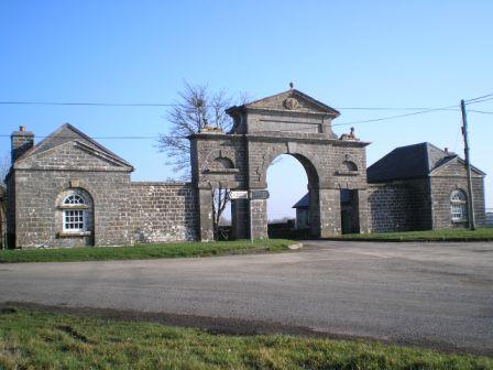
| Bellevue/Lisreaghan | Belview was the main seat of the Laurence family in east Galway. Wilson, writing in 1786, refers to "Belle-view" as the seat of Mr. Lawrence "with beautiful plantations". In the 1850s it was valued at £42 and was occupied by Walter Laurence jun. In 1906 it was the property of Rev. Charles Lawrence. It is no longer extant but a famous gateway, erected in support of the Volunteers of 1782, is still visible. |
|
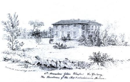
| St. Brendan's | Archdeacon Butson is listed as the occupier of the house in Glebe townland in 1855 when it was valued at £25. It is labelled St. Brendan's on both the 1st and 25-inch edition Ordnance Survey Maps. This house is no longer extant. |
|
| Abbeyland Cottage | A herd's house in the townland of Abbeyland Great, parish of Clonfert, barony of Longford, was part of Archdeacon Butson's estate. It was valued at £1 10 at the time of Griffith's Valuation and leased to John Kenny. This house is no longer extant. | |
| Cloonconra | A house in the townland of Cloonconra, parish of Clonfert, barony of Longford, was valued at £10. It was part of Archdeacon Butson's estate at the time of Griffith's Valuation. It is labelled Cloonconra Farm on the 25-inch Ordnance Survey map of the 1890s. A farm still exists at the site. | |
| Clonfert Palace | Clonfert Palace was built in the late 17th century and altered in the 18th century. It was the residence of the Church of Ireland bishop of Clonfert until 1836 when that diocese was amalgamated with Killaloe. At the time of Griffith's Valuation, John E. Trench was leasing the property valued at £20 from the Ecclesiastical Commissioners in the townland of Clonfert Demesne, barony of Longford, county Galway. In 1906 it was in the ownership of Charles O'Hara Trench. Later occupied by the British fascist leader, Oswald Mosley. It was damaged by fire in 1954 and has been derelict since. |
|
| Clonfert Cottage | In 1855, a house valued at £8 and belonging to the representatives of Robert Seymour, was leased by James Buchanan. Slater refers to "Clonfert Cottage" as the residence of Robert Seymour in 1846. On the 25-inch maps of 1890s the property at this site is labelled "Constabulary Barracks". | |
| Cloonkea | John Eyre was leasing a house valued at £10 from the estate of Dr. Duggan in 1855. The house was located at Cloonkea, barony of Longford. It was advertised for sale in 2007. |
|
| Lismore | Henry Kenny was leasing a property valued at £8 from Lord Dunsandle in 1855. It was located at Lismore Demesne, parish of Clonfert. Lismore Castle is shown there on the 1st edition Ordnance Survey map. By the 1890s this building is in ruins but Lismore Farm (M943160) is located nearby. Ruins of both buildings are still visible at the site. MacLysaght, in his 1944 report on the Dunsandle papers, notes the existence of deeds relating to Fergus Madden of Lismore. | |
| Hemmings Ville | The representatives of Robert Seymour were leasing a house valued at £6 and almost to 250 acres to Sidney Smith in 1855. This property is labelled "Hemming's Ville" on both the First and 25-inch editions of the Ordnance Survey maps. There is still an extant house at the site. | |
| Kilnaborris Dower House | John Seymour was leasing a property valued at £8 from Hubert Moore at the time of Griffith's Valuation. It was located in the townland of Kilnaborris, parish of Clonfert. Kilnaborris Dower House is still extant and now offered as holiday accommodation. |
|
| Shannon View | Belinda C. Madden is listed as the lessor of two properties in the townland of Kilnaborris, parish of Clonfert, in 1855. The property which appears to have been known as Shannon View was vacant at this time. It was valued at £12. In July 1889 property at Kilnaborris, or Shannon View was offered for sale in the Land Judges' Court by William C. Bermingham Ruthven. The sale was adjourned. In 1783 Taylor and Skinner had recorded it as a residence of the Madden family. In 1786 Wilson refers to Kilnaborris as the seat of Mr. Madden. The National Inventory of Architectural Heritage suggests the house now extant on the site was built c.1870. It suffered fire damage in the twentieth century but was rebuilt c.2002. The house is now known as Lairakeen. |
|
| Shannon Grove | Shannon Grove was valued at £20 and was leased to Hubert Moore in 1855. William R. Seton was the owner of a house valued at £65 in the townland of Kilnaborris in 1906. Leet's Directory records Shannon Grove as the residence of Hon. B. Yelverton in 1814. A substantial house still exists at Shannon Grove. |
|
| Killeragh | At the time of Griffith's Valuation, Thomas Kenny was occupying a property valued at £5 together with 180 acres, in the townland of Killeragh, parish of Clonfert, barony of Longford. A house is still extant at the site. | |
| Oghil | At the time of Griffith's Valuation, Allan Pollok held a property at Oghil More townland, parish of Clonfert, on which a house was in progress, together with a mill and other buildings. The property stood on 368 acres. The mill chimney was demolished during the later twentieth century but many of the other buildings remain. | |
| Sycamorehill | At the time of Griffith's Valuation, Allan Pollok held a property at Sycamorehill, parish of Clonfert, valued at £16. Molloy states that this house was burned during land agitation on the Pollok estate in the 1850s but it was subsequently re-built. Sycamorehill is still extant and part of a large farm. |

|
| Coolcarta Farm | At the time of Griffith's Valuation Allan Pollok held a property valued at £20 in the townland of Annaghcorrib, parish of Clonfert, barony of Longford. It is labelled as Coolcarta Farm on the 25-inch Ordnance Survey map of the 1890s. Padraig Lane states that this property was damaged by fire during land agitation in the 1850s. A substantial farm still exists at the site. | |
| Kylemore Dairy | Allan Pollok held a property valued at £7 together with over 400 acres in the townland of Kylemore, parish of Clonfert, barony of Longford in 1856. On the 25-inch Ordnance survey map of the 1890s there is a property labelled Kylemore Dairy in this townland. Parts of the farm buildings remain at the site. | |
| Coolbeg House | In 1856 Thomas Stratford Eyre was leasing a property valued at £5 together with 146 acres, located in the townland of Coolbeg, parish of Clontuskert, barony of Longford to William Seymour. It is labelled Coolbeg House on the 25-inch Ordnance Survey map of the 1890s. A house still exists at the site. | |
| Crowsnest | In 1856 Allan Pollok was the occupier and lessor of a property valued at £6 together with over 460 acres, in the townland of Crowsnest, parish of Clontuskert, barony of Longford. Molloy provides a detailed description of the huge farmyard (M868239) in the neighbouring townland of Ganaveen which was part of the Pollok estate. The latter was destroyed by fire in 1920. The Crowsnest property is now in ruins. |

|
| Lismany/Lismanny | Allan Pollok's estate was centred on the property at Lismany. In 1856 the buildings there were valued at £10. In 1906 Lismanny was owned by the representatives of John Pollok. It was valued at £90. It was sold by the Pollok family in 1924 and demolished some years later. Only the cellar of the house together with the ruins of an extensive range of estate buildings now remains at Lismanny. However both gatelodges and several other estate houses are still occupied. |
|
| Huntly | Denis Delahunt was recorded as the occupier of a house, valued at £8, at Feagh, in the parish of Kiltormer, at the time of Griffith's Valuation. In 1906 the house at Feagh was owned by John A. O'Kelly and was valued at almost £6. A substantial modern farm exists at the site. | |
| Newpark | At the time of Griffith's Valuation, Peter Callanan occupied a house valued at £10 in the townland of Skecoor, parish of Kiltormer, barony of Longford. Lewis records this house as the seat of P. Callaghan in 1837. In 1894 and 1906 it was the home of Rosa Callanan. Now known as Skycur House it is still extant and well-maintained. |
|
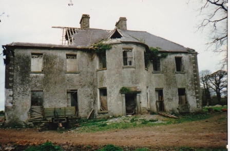
| Gortnamona | In the early years of the 19th century Gortnamona was the residence of Giles Eyre. It had originally been a Burke house but became part of the Blake estate in the mid 19th century when Valentine Blake married Anne Burke. Lewis records it as the seat of Patrick Blake in 1837. He was also resident there at the time of Griffith's Valuation when it was valued at £25. It is still extant but in need of repair. |
|
| Lisbeg | In 1906 the representatives of John Pollok were in possession of a house and buildings valued at £65 at Lisbeg, parish of Clonfert. At the time of Griffith's Valuation Allen Pollok had owned the townland of 353 acres and a herd's house valued at almost £3. The National Inventory of Architectural Heritage states that it was re-built after a fire in the 1890s and occupied by John Gardiner at that time. It is still extant and occupied. |

|
| Correen | At the time of Griffith's Valuation, William T. Potts was occupying the house at Correen, barony of Moycarn, valued at £22. The current house was built in the early 1830s but the Potts family were resident there prior to that as "Carrine" is recorded as their residence by Wilson in 1786. In 1837 the Ordnance Survey Field Name books describe Correen House as "a gentleman's place in very good repair on a demesne of over 300 acres". The building is still extant and occupied as a private residence. |
|
| Longford House (Tirnascragh) | At the time of Griffith's Valuation, George Kenny was occupying a property valued at almost £7 at Longford. Hogan states that Longford House was built c.1844-1850. It passed from the Kenny family to Major Longbourne in the 1890s but Hogan records that he sold the estate in 1902. In 1906 the Congested Districts Board are recorded as the owners and the house was valued at £12 at the time. It passed to the Stoddart family in 1914 and is still extant and occupied. |
|
| Chesterfield | A property named Chesterfield is recorded on the 1st edition OS Map, located at Cloonineen, parish of Kiltormer. At the time of Griffith's Valuation, Thomas S. Eyre owned this townland amounting to over 300 acres and also held a herd's house there valued at 15s. The property is still labelled Chesterfield on the 25-inch map of the 1890s but is much reduced. It is no longer extant. | |
| Lissanacody | The Pollok estate held a steward and caretakers' houses at Lissanacody, barony of Longford at the time of Griffith's Valuation, valued at £6 between them. In 1906 the property was part of the estate of the John Pollok's representatives and was valued at £7.Molloy writes that these buildings, which were unoccupied at the time, were damaged by fire in 1854. Some farm buildings remain at the site. | |
| Redwood House | Redwood was the home of the Bloomfield family in county Tipperary, occupied by Major Bloomfield in 1837. In 1840 the Ordnance Survey Name Books mention that Redwood was "a commodious house, at present occupied by a party of the constabulary and also the residence of Mr. Ryan, under-agent to Maj. Bloomfield". It is marked as a police station on the 1st edition Ordnance Survey map. At the time of Griffith's Valuation. Phillip Crawley held the property from Lord Bloomfield and the house was valued at £15. Redwood House later became a Trench home, valued at £18.15 shillings in 1906. It no longer exists. | |
| Redwood | Marked on the first edition Ordnance Survey map as Moatfield House and on later maps as Redwood. Moate-field, Burris-a-kane, was the home of William Clarke in 1814. In 1841 the Ordnance Survey Name Books refer to it as "Moat Field, a good dwelling house the residence of Miss Clarke". In the mid 19th century Robert Daly held a house valued at £15 and 324 acres in Redwood from Lord Bloomfield. Redwood is still extant. | |
| Woodfield House (Donanaghta) | At the time of Griffith's Valuation, Timothy Egan was leasing a property valued at £7 from the Clanricarde estate. On the 25-inch map of the 1890s the house in this townland is labelled Woodfield. It is still extant and occupied. The first edition Ordnance Survey map notes an old brewery nearby. |
|
| Annaghcallow | The property at Annaghcallow was leased by John Ryder from Cornelius O'Kelly at the time of Griffith's Valuation, when it was valued at £3. A farm still exists at the site. |