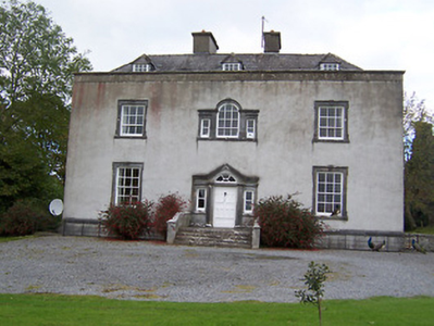
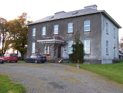
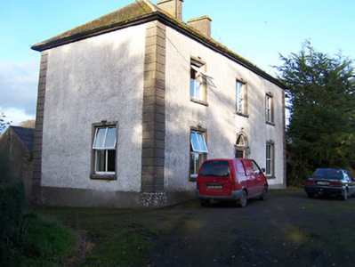
Glenown/Clonown
Houses within 5km of this house
Displaying 13 houses.
Houses within 5km of Glenown/Clonown
Displaying 13 houses.
| House name | Description | |
|---|---|---|
| Ballintober (Kilcumreragh) | Ballintober House is named on both the first edition OS map and the early 20th century 25 inch map, but no longer appears to be extant. In 1837 William Fetherstonhaugh was resident and in the mid-19th century it was the home of James Fetherston Haugh, held from Dorothea Horton and valued at £20. In the 1870s James Fetherstonhaugh of Ballintober owned 39 acres in county Westmeath. Ballintober was still in Fetherston Haugh occupation in 1901 but unoccupied by 1911. This was a branch of the Mosstown and Bracklyn Fetherstonhaugh family. | |
| Rosemount House/Oldcourt | Rose Mount House is also known as Old Court, both names appear on the OS maps. The village nearby is known as Rosemount. Described by buildings of Ireland as a well-balanced structure originally built by the Geoghegan Family in the late eighteenth-century, probably replacing an earlier house. Leet records John Pim occupying a house named Rosemount near Moate in 1814 and Lewis records Lady Nagle as the occupant in 1837. O’Brien writes that it was inherited by the Nugent family of Ballinacor through marriage. At the time of Griffith’s Valuation it was occupied by John J Nugent who held it from the representatives of Sir Richard Nagle. It was valued at £21.10. Still extant and occupied. |
|
| Coolatore | This house was not built at the time of the first edition OS survey. It was constructed about 1866 and was the home of members of the Upton family. In 1906 it was valued at £56, occupied by Henry N S Upton who held it with over 400 acres of untenanted land. According to the discover Ireland website it now provides self-catering accommodation. |

|
| Grouse Lodge | Grouse Lodge is named on both the first 6 inch and 25 inch OS maps. Described as a three-bay two-storey over basement country house with attic level, built c.1810 (boi), now in use as a residential recording studio. Grouse Lodge was built by a branch of the Fetherstonhaugh Family of Ardagh, County Longford and was occupied by Theodore Fetherston in 1814 and by William Fetherstonhaugh at the time of Griffith’s Valuation. The building valued at £24 was held from Edward Fetherstonhaugh, who was the occupant in 1837. It is still a family home. |

|
| Redmondstown | Redmondstown is named on the first edition OS map and 25 inch map. The National Built Heritage Service records that the main entrance was erected about 1800. In 1814 John Tisdall is recorded as resident. At the time of Griffith’s Valuation (publ. 1854) it was occupied by Frederick Hart who held the house valued at £10 from Jerome Tisdall. The house is now demolished. | |
| Jamestown Court | Jamestown Court is located to the north west of Castle Geoghegan. It is a three-bay two-storey over basement country house with six-bay single-storey over basement wings to either side (boi). It was originally built in 1740, the date is inscribed on a window opening but was substantially altered at a later date which may be why Lewis records it in 1837 as a ‘spacious and handsome castellated mansion of modern erection’. This house was the home of the Nagle family and the property was originally in the ownership of the McGeoghegan family who were direct ancestors of the Nagles. From the late 18th century Jamestown Court was the home of Sir Richard Nagle, Baronet. He also had connections with Donore Castle, near Horseleap, which he ‘restored’ in 1809. Jamestown Court was later the seat of Sir Richard Neagle (Nagle) Geoghegan 2nd Bt in 1846 (Slater’s Directory). Following his death in 1850 it was inherited by his sister Frances Mary who was married to John Grace of Mantua House, Co Roscommon. At the time of Griffith’s Valuation (publ. 1854) the house was valued at £13, occupied by John Lynam who held the property from John Ennis with 156 acres. The rest of the townland was held by John Grace. In 1901 and 1911 occupied by Lt Colonel Gilbert Lavillan Nugent and family. For sale in 2012 and bought in 2013. |
|
| Charleville/Lunestown House | This building was named Charleville House on the first edition OS map and Lunestown House on the 25 inch map. A late 18th century five-bay two-storey over basement country house, built 1790 (keystone) and altered c. 1830 and c.1890. Charles Kelly built the house and its first name was derived from his Christian name. He was the occupant in 1814. In 1837 Lewis recorded Charleville as the seat of C Kelly and in the mid-19th century John Hubert Kelly held the house valued at £22 from William H Magan MP. Martin Charles Kelly JP and his wife Emily were resident in 1901 and 1911. |
|
| Togherstown | Togherstown House, named The Lodge on the first edition OS map with a small demesne. This is a three-bay two-storey over basement house, built before 1837 possibly incorporating the remains of an earlier house c.1700 built by Thomas Magan, High Sheriff of Co Westmeath. By 1837 Togherstown House was in the occupation of William Thomas Dillon (d. 1870). It was valued at £22 at the time of Griffith’s Valuation (publ. 1854), William T Dillon holding it from William H Magan MP. William Thomas Dillon was the son of Thomas Dillon of Lung, county Mayo and was married to Teresa daughter of Edmund Count Nugent of Ballinacor, county Westmeath. Margaret Treddin, widow and caretaker, and her family were resident in 1901 and 1911 holding the property from Julia Dillon of Dublin. The house was restored in the 21st century. |
|
| Killare House | Killare House is named on the first edition OS map, it is now a green field site as O'Brien notes it is long demolished. Valued at £12 at the time of Griffith’s Valuation (publ. 1854) it was occupied by Robert Matthews and held from Reverend Dean Pakenham. | |
| Mosstown | Mosstown House named on both the first edition OS map and the 25 inch map. O’Brien writes that Mosstown was originally a property belonging to the Judge family and was sold to Cuthbert Fetherstonhaugh in 1790 and he was recorded as occupant in 1814. In 1837 it was recorded as ‘the principal seat’ of the parish ‘the handsome residence of Theobald Fetherston H.’ It remained a Fethetstonhaugh property until sold to William Dargan in the Encumbered Estates Court in 1851 (O’Brien). At the time of Griffith’s Valuation (publ. 1854) it was valued at £40 and occupied by Thomas Smith who held it from William Dargan. Later this house was occupied by members of the Fosberry and Adamson families. In 1906 George A G Adamson was the occupant. The house was destroyed by fire in 1938 and is now a green field site. | |
| Streamstown House | Streamstown House, just north of the Mullingar to Athlone greenway and marked on the first edition OS map, is a five-bay two-storey over basement country house, built c.1820 (boi). The interest of John Thomas Barlow, assignee of James Nugent, in the mansion house and lands of Streamstown were for sale in the Encumbered Estates Court on 12 February 1852. The property was held under a lease for lives for ever, the last renewal in 1846 was from William Palmer to John Thomas Barlow. At the time of Griffith’s Valuation (publ. 1854) Streamstown was the residence of Captain James H Dickson, valued at £20 and held from William Palmer. By 1906 Anne Somers was in occupation. |
|
| Ballyhast House | Ballyhast House is named on the first edition OS map and the 25 inch map. At the time of Griffith’s Valuation (publ. 1854) it was valued at £12, occupied by Rose Colgan and held from Alicia O’Connor Malone (in Chancery). Eugene Charles Dennis Colgan, farmer, was resident in 1901 and also in 1911 when his wife and family are recorded in the census. There is a building still at the site, the centre of a stud farm. | |
| Rockfield | Rockfield is named on the first edition OS map, this three-bay two-storey house was built c.1785. For sale in 1853 when the 'mansion house' was not in full repair. Mark Colgan was the tenant. It was held on a lease from Nicholas and Francis Evans. At the time of Griffith’s Valuation (publ. 1854) it was occupied by Marcus Colgan and held from John Elliott. It was valued at £13. Joseph Clavin, farmer and his family were the occupants in the early 20th century. This house is till part of a farm complex. |
|