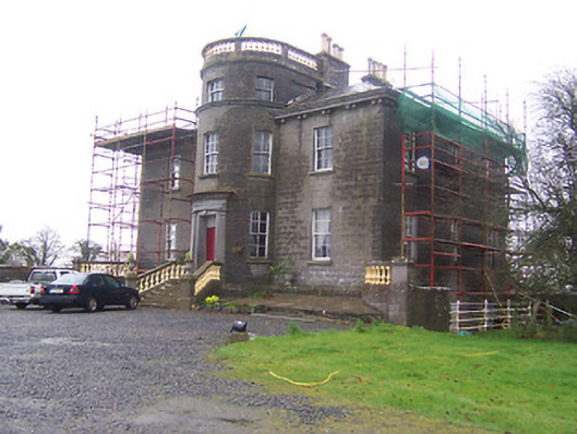
Coolure
Houses within 10km of this house
Displaying 42 houses.
Houses within 10km of Coolure
Displaying 42 houses.
| House name | Description | |
|---|---|---|
| Moneyhoolaghan House | Benjamin Lloyd was leasing Moneyhoolaghan from the Blackall estate at the time of Griffiths Valuation in the early 1850s, when it was valued at £16. The National Built Heritage Service suggests the current house was built c.1880. It is still extant. |
|
| Coolamber | Philip O’Reilly was leasing this property from the Blackall estate at the time of Griffiths Valuation, when it was valued at almost £23. The property was associated with the Blackall family by whom, according to O'Brien, it was built c.1830. Later in the nineteenth century it came into the possession of the O’Reilly family. Towards the end of World War II it was, for a time, the home of Prince Ernest, Duke of Saxony. Since the early 21st century, it has been undergoing restoration and now serves as venue for occasional gardening courses. |
|
| New Grove (Longford) | John Hynds was leasing this property from the Hamilton estate at the time of Griffiths Valuation in the 1850s, when it was valued at over £11. In 1837 Lewis referred to it as the seat of R. J. Hinds. It is now a ruin. In the 1870s, John Hinds of New Grove was recorded as the owner of over 240 acres in County Longford. |
|
| Killasona House | Killasona House was occupied by Owen McCormack at the time of Griffiths Valuation in the early 1850s when it was valued at £10. It was leased from Richard Greville’s estate. McCormick was recorded as the owner of over 400 acres in County Longford in the 1870s. In 1906 it was owned by Richard Davoron and valued at over £17. It is still extant but disused. |

|
| Kilmore House (Westmeath) | At the time of Griffiths Valuation, Kilmore House was leased by Reverend Francis Kane from Reverend William Bowles and was valued at £10. The house is not visible on the 1st edition OS map but is labelled Kilmore House on the 25-inch edition. It is still extant and part of a farming enterprise. Lewis noted that the living of Kilmore was in the patronage of Fulke Greville in 1837. Reverend Francis Kane was afterwards rector of the parish of Fenagh, County Leitrim, from 1869 until his death in 1882. He had previously been vicar in the parish of Russagh, nearby to Street, County Westmeath, 1848-1855. | |
| Ardglass House | This house was rebuilt in the style of an Italianate Villa post Griffith’s Valuation, possibly incorporating the fabric of an earlier house on the same site. The original Ardglass House was the home of a Major A. P. Bond in 1837. Valued at £13.15 at the time of Griffith’s Valuation (publ. 1854), it was occupied by the representatives of A P Bond who held it in fee. The present house was in the ownership of William Perry Bond JP, in the 1880s. The house has had various owners in the 20th century and was for sale in 2017, see https://www.businesspost.ie/article/high-class-at-ardglass-co-westmeath/ | |
| Newpark Lodge | Newpark Lodge named on both the first edition OS map and the 25 inch map. Occupied by James Auchmuty JP in 1837 and at the time of Griffith’s Valuation (publ. 1854) when he held the house valued at £10 from the representative of A P Boyd. Now a modern building located at the site situated on the main road from Mullingar to Edgeworthstown. Newpark Lodge was for sale in 2021. | |
| Daramona House | The National Built Heritage Service suggests this house was built c.1850 by the Wilson family. In later times there was also an observatory at the site. At the time of Griffiths Valuation, it was held in fee by William Wilson and valued at over £28. In 1906 it was owned by John Wilson and valued at almost £73. It is still extant though apparently not in use. |
|
| Newtown House (Fore) | This house was enlarged after the publication of the 1st edition Ordnance Survey map in the 1830s. Elizabeth Ferrally was leasing the property from the Pakenham estate at the time of Griffiths Valuation in the early 1850s when it was valued at £9. The Valuation Office books of 1838 also noted her as the owner when the house had a valuation of almost £6. A house is still extant at the site. | |
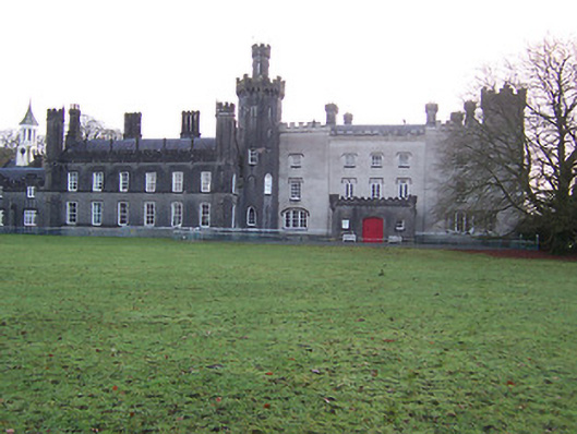
| Tullynally Castle | The National Built Heritage Service suggests the bulk of Tullynally Castle was built c.1730 but may incorporate the fabric of a house built for Henry Pakenham in the mid-C17. It had a number of phases of construction throughout its long history. Formerly known as Pakenham Hall, it has been the seat of the Pakenham family for over 350 years. At the time of Griffiths Valuation in the mid-1850s it was valued at £200 and had the same valuation in 1906. It is still extant and occupied by the Pakenham family. |
|
| Tromra House | Tromra was being leased by Wiilliam Riggs from the Pakenham estate at the time of Griffiths Valuation in the early 1850s when it was valued at £13. The Valuation Office Books of 1839 indicate Mrs. Mary Anne Riggs was occupying a property valued at £10 at that time. Tromra is still extant and occupied. |
|
| Wilson's Hospital | Wilson's Hospital School erected on the summit of a hill, was founded by a trust set up by Andrew Wilson of Piersfield [Piercefield]. The National Built Heritage Service records that Wilson stated in his will of 1724 that in the event of there being no direct male heirs to his estate that it, and all its profits, be transferred to the Church of Ireland hierarchy and used to build a hospital for aged Protestant men and a school for poor Protestant boys. This was the case by 1743 and the school was completed in 1761. ‘Wilson's Hospital is one of the finest and most sophisticated mid-Georgian buildings constructed outside of Dublin. Its design has been attributed John Pentland, a noted architect of his day, and it is built in the style of a Palladian country house’ (boi). It is a seven-bay two-storey building which was valued at £90 at the time of Griffith’s Valuation (publ. 1854) and continues to function as a secondary co-educational boarding school today. | |
| Lackan | Lackan house is marked but not named on the first edition OS map. It was a two-storey, three-bay house, the home of the Delamare family, long associated with the Multyfarnham area. The Taylor and Skinner maps of the late 1770s include reference to Delamar at Lacken. In 1837 Lackan was the seat of Mrs Delamere. It was unoccupied at the time of Griffith’s Valuation (publ. 1854) when valued at £17. The immediate lessor was Patrick J Murphy. A number of Delemere families were still resident in the townland in 1901. This house has been demolished. | |
| Clanhugh | Named on the first edition OS map as Clanhugh Lodge overlooking Lough Owel, later rebuilt as shown on the 25 inch map when it is named Clonhugh. The earlier house Clanhugh Lodge was the residence of the Earl of Granard in 1814 and in 1837 described as a lodge belonging to Lord Forbes. Valued at £12 the building was occupied by James Lugden who held it from the Earl at the time of Griffith’s Valuation (publ. 1854). The present five-bay two-storey Italianate country house, was built in 1867, to the design of William Caldbeck (1824-1872), for Colonel F.S. Greville, later Lord Greville, who purchased much of the Forbes lands in this area in 1859. Francis Nulty of Kells was the builder. Occupied by the Harvey-Kelly and Beirne families in the 20th century. | |
| Rathbennett House | Rathbennett House, formerly known as Farra House, originally functioned as Bunbrosna Charter School. Built c.1758 with a bequest from the will of the Rev. William Wilson, the nephew and heir of Andrew Wilson, the benefactor of Wilson's Hospital. Farra Charter School is recorded by Lewis in 1837 and was still recorded as a charter school with offices at the time of Griffith’s Valuation (publ. 1854) when the building was valued at £30. It was held by the trustees of Wilson’s Hospital in fee. Sometime later it became a private residence. Occupied by Thomas Cartret Foster in 1901 and 1911, this house remains a family home. |
|
| Ballinacloon | Ballynaclonagh, named on the first edition OS map as Ballynaclonagh and on the 25 inch map as Ballinacloon and extended. No longer extant, demolished c 1930. Complex of single and two-storey outbuildings on L-shaped plan survive. Ballynaclonagh was the residence of Edward Murphy in 1814 and P. E. Murphy in 1837. Griffith’s Valuation (publ. 1854) records Patrick E Murphy as the occupier holding the property valued at £33.5 in fee. Patrick Delamere, coachman to Captain Murphy, was resident with his wife in 1901. Valued at £45.5 in 1906 and in the possession of Captain Laurence Murphy. The Delameres had three children by 1911 and were resident holding the property from Mrs Sarah Murphy. | |
| Donore House | Donore overlooking Lough Derravaragh, named on the first edition OS map. The Nugents were settled here from the 16th century. Donore House was a three-storey late 18th century Georgian block. James Nugent of Donore was created a baronet in 1768. When his brother Peter the second baronet died in 1797, Donore passed to the family of their sister Catherine who had married Pierce Fitzgerald of Baltinoran. They had two sons Thomas who inherited Donore and Lattin who inherited Soho House. In 1831 Thomas’ son Percy Fitzgerald Nugent was created a baronet and was MP for Westmeath 1847-1852. He was resident at the time of Griffith’s Valuation (publ. 1854) when the house was valued at £80. The Nugents were still resident in the early 20th century. O’Brien writes that the house was given to the Franciscan Community of Multyfarnham from whom it was purchased by the Land Commission. The house fell into disrepair and was demolished in the 1960s. | |
| Monintown/Mornington | Monintown or Mornington House, straddles the border between the parishes of Mutlyfarnham and Stonehall as shown on the first edition six inch OS and the 25 inch maps as Moninton. The original two-storey house was built in the mid-18th century and was the home of the Daly family. It was the seat of Owen Daly in 1837 and Edward Daly held it in fee at the time of Griffith’s Valuation (publ. 1854). It was valued at £7.10, while a building he held in the parish of Stonehall was valued at £8. In the late 19th century a five-bay two-storey house was built to the front of the original house by the O’Hara family who acquired the property in 1858. In 1906 the house was valued at £43.13 and was in the possession of Patrick O’Hara. Still in the ownership of the O’Haras, who run it as a guest house. |
|
| Soho (Multyfarnham) | Soho, an early 19th century three-bay two-storey house, is named on the first edition OS map. Inherited by Lattin Fitzgerald, a younger son of Catherine Nugent of Donore and her husband Pierce Fitzgerald, who occupied the house in 1814. At the time of Griffith’s Valuation (publ. 1854) it was the residence of Peter Nugent Fitzgerald, valued at £15.15 and held from Sir Percy Nugent of Donore. The house was occupied by Mrs Margaret Fitzgerald’s gardener Edward Fay in 1901 and by Colonel Edward Irwin and family in 1911. Soho is still a family home. |
|
| Woodland | Woodland overlooking Lough Owel, named on the first edition OS map and 25 inch map, still extant but now known as Ardilaun House. Lewis records W Moxton, agent to Lord Forbes, as the occupant in 1837 and at the time of Griffith’s Valuation (publ. 1854) Edward Maxton was resident holding the property valued at £14 from Lord Forbes. In 1901 occupied by race horse trainer Alexander Pilkington and his wife and by the Brabazon family, horse trainers in 1911. | |
| Mount Murray | Mount Murray House is situated facing the western shore of Lough Owel and is named on both the first edition OS and 25 inch maps. The Murray family have been resident here since the mid-17th century and remain in residence today. The present house is a five-bay two-storey over basement country house, built about 1780 and remodelled c.1820 with the addition of a semi-circular bow to the southeast façade (boi). It was built by Alexander Murray in the late eighteenth-century to replace an earlier Murray house or castle close to the same site. Occupied by Alexander Murray in 1814 and 1837 and by Henry Murray at the time of Griffith’s Valuation (publ. 1854) who held the house valued at £46 in fee. William Murray was resident in 1906. |
|
| Martinstown | Martinstown is marked on the first edition OS map but is named on the later 25 inch map. It was built c.1820, on a L-shaped plan with two-storey return to the rear (boi). John Kerr held most of this townland from Thomas R Evans at this time and occupied the house valued at £12. Other Kerr family members occupied houses valued at £7 and £8.10. |
|
| Kilmaglish | Kilmaglish House not built at time of first edition OS map but is marked on the 25 inch map. At the time of Griffith’s Valuation (publ. 1854) it was valued at £17, occupied by William Levinge and held from Sir Richard Levinge. Occupied by Thomas Robinson, a farmer and his son William in 1901 and 1911. It is still extant surrounded by large farmyard. | |
| Ballyknock House | Ballyknock House, Derrynagarragh, is marked on the first edition OS map at a road junction and named on the 25 inch map and appears to be extant. In 1814 Ballyknock was the residence of Richard McCormick. At the time of Griffith’s Valuation (publ. 1854) it was valued at £16.10, occupied by Catherine McCormick and held from Richard McCormick. It appears to have been located on the Berry estate. | |
| Gartlandstown House | Gartlandstown House, located at the south eastern toe of Lough Derravargh, is a five-bay two-storey house, built about 1830 (boi) or perhaps replacing an earlier house as Garlandstown, Castlepollard, was the seat of Sterne Tighe in 1814. By 1837 J Murray was resident here and James Murray is recorded as the occupant at the time of Griffith’s Valuation (publ. 1854) when the house was valued at £10 and held from James W M Berry. O’Brien writes that Michael Hope was resident in 1869 and in the mid-1870s the representatives of Michael Hope held 487 acres at Gartlandstown. Members of the Hope family was still in occupation at the time of the 1901 and 1911 censuses. |
|
| Kinturk House | Kinturk House, located just south of Castlepollard, is a five-bay three-storey over basement country house, built about 1760, remodelled and extended in 1821 for William Dutton Pollard (1789-1839) by Charles Robert Cockerell (1788-1863). It was valued at £90 in 1906. The house remained in the possession of the Pollard/Pollard Urquhart family until the mid-1930s when it was sold to the Congregation of the Sacred Hearts of Jesus and Mary who, in turn, sold it on to the Midland Health Board in 1971. |

|
| Benison Lodge | Benison Lodge, west of Lough Lene, is named on both the first edition six inch and 25 inch OS maps. O’Brien describes it as a late 18th century, five-bay, two-storey house, probably by the O’Reilly family, one of whom was shot dead in the house in 1803 by the coachman. In 1814 Thomas H Smyth lived here and the Rev T Smyth in 1837. By the time of Griffith’s Valuation (publ. 1854) John Henry Roper was occupying the house, valued at £30 and held from William P Urquhart of Castlepollard. In the 1870s Henry J Roper of Benison Lodge owned 447 acres. In the early 20th century Richard O’Neill and family were living in a first class house in this townland. The house is now a ruin. | |
| Sallymount House | Sallymount House is a three-bay two-storey house with dormer attic, dating from the early 19th century. It was the home of the Rotheram family for much of the 19th and 20th centuries. The Rotherams acquired it from the Nugent family. G S Rotheram was resident in 1837 and Griffith’s Valuation (publ. 1854) records George Rothram as the occupant holding the house valued at £35 from Priscilla Nugent. Members of the Rotheram family owned 560 acres in the 1870s. The estate was acquired by the Land Commission in the early 1960s and the house became derelict but has been restored recently. | |
| Gillardstown | Gillardstown is named on both the first edition six inch and 25 inch OS maps. A Mrs Scully was living at Gillerstown, Castlepollard, in 1814. At the time of Griffith’s Valuation (publ. 1854) Thomas Webb occupied the house, valued at £25 and held from Robert A Ellis. The house was the home of William Evans, a Civil Engineer and Law Agent, and his family in 1901 and of William Hardy, a farmer and his wife in 1911. The house is now the centre of a farming complex. | |
| Hilltown | Hilltown House, built in front of the ruins of a castle, is a three-bay three-storey over basement Palladian country house, built about 1780, possibly by William Webb. It was the home of William Webb in 1814 and in 1837. Valued at £26 at the time of Griffith’s Valuation (publ. 1854) it was occupied by George Webb and held from Lady Oranmore [and Browne]. Members of the Webb family were still resident in the early 20th century and O’Brien writes that the estate was acquired by the Land Commission. The house is still a private residence. |
|
| Loughpark | Lough Park House, situated on the shores of Lough Lene to the south east of Castlepollard, this five-bay two-storey house, built about 1790 was home to the Evans family for much of the 19th century. N Evans was resident in 1837 and Michael Evans at the time of Griffith’s Valuation (publ. 1854). He held the house valued at £20 from William P Urquhart of Castlepollard. Thomas Pender, farmer and family lived here in 1901 and Samuel R Sutton, farmer and family in 1911. The property remains a family home. |
|
| Carlanstown | At the time of Griffiths Valuation Wiilliam McCullogh was leasing this property from the Duke of Buckingham’s estate when it was valued at £13. It is located close to the site of Carlanstown Castle and labelled Carlanstown House on the 25-inch Ordnance survey map. O'Brien suggests it was built c,1830. Both he and the National Inventory of Architectural Heritage provide extensive details of its associations with older structures at the site and the connections with the Nugent family. Carlanstown is still extant and occupied. |

|
| Gaulstown House (Fore) | The National Inventory of Architectural Heritage suggests this house was built about 1730. At the time of Griffiths Valuation it was occupied by Andrew Mulligan, leasing from Hubert de Burgh’s estate, when it was valued at £21. It had previously been the seat of the Lill family who had succeeded to de Burgh property and adopted that surname. The house is labelled Gaulstown on the 25-inch Ordnance Survey map. It is still extant. |
|
| Castletown Cottage | At the time of Griffiths Valuation this property was held in fee by Samuel Reynell when it was valued at almost £8. O'Brien suggests that the original property was built c.1840. The National Inventory of Architectural Heritage indicates it was extended in the mid C19. The Valuation Office books of 1841 noted a house valued at almost £7 in this townland, then occupied by James Campbell. The house is labelled Castletown Cottage on the 25-inch edition OS map of the early C20. It is still extant and in use. |
|
| Lickbla House [ Rockbrook](Fore) | Thomas Fagan was leasing this property from James Fallon at the time of Griffiths Valuation in the early 1850s when it was valued at almost £19 and included a mill. In 1906 it was the property of Patrick J. Fagan and valued at almost £21. The National Inventory of Architectural Heritage suggests that it dates from c.1800 but with later modifications. It is labelled Rockbrook on the 1st edition OS map but as Lickbla House on later editions and is still extant and occupied. |
](https://landedestates.ie/storage/img/orig/3618.png)
|
| Newcastle (Fore) | Walter Keating was occupying Newcastle at the time of Griffiths Valuation in the early 1850s when it was leased from the Urquhart estate and valued at £19. In 1839 the Valuation Office Books indicate that George Keating was the occupier with a valuation of £23. It is still extant. | |
| Derrya | At the time of Griffiths Valuation in the early 1850s William Pollard Urquhart was leasing a herd’s house at this location from the estate of Richard Pakenham, when it was valued at almost £11. The Valuation Office books of 1839 noted the owner as Captain William Pakenham and the valuation was £12. The Untenanted Demesnes survey of 1906 indicates it belonged to Hugh P. Wilson and was valued at over £10. The building is still extant but derelict. | |
| Turbotstown [Turbotstown House] | The National Inventory of Architectural Heritage suggests that the present house at Turbotstown was built in the early decades of the nineteenth century, on the site of an earlier house. At the time of Griffiths Valuation in the early 1850s it was held in fee by Gerald Dease when the buildings were valued at £80. In 1906 it was still the property of Major Gerald Dease and valued at £84. It was occupied by the Dease family until the 20th century and is still extant. O'Brien provides a detailed account of this house and its occupants. On the 1st edition Ordnance Survey map it is labelled Turbotstown House but on the 25-inch edition of the early 20th century it is labelled Turbotston. |
![Photo of Turbotstown [Turbotstown House]](https://landedestates.ie/storage/img/orig/3616.png)
|
| Lakeview House (Fore) | John Smith was leasing this property from Reverend Thomas Smith at the time of Griffiths Valuation when it was valued at £15. The Valuation Office books of 1838 state that the house then held by Reverend Thomas Smith was valued at £16. It is still extant and in use. | |
| Mayne Glebe [Mayne Rectory] | Mayne Rectory was leased by Reverend William Eames from the estate of Reverend Thomas Smith at the time of Griffiths Valuation when it was valued at £8. In 1839, the Valuation Office books recorded that it was occupied by Reverend Richard Handy and had a valuation of almost £9. The National Inventory of Architectural Heritage suggests it was built c.1812. It is still extant and in use. |
![Photo of Mayne Glebe [Mayne Rectory]](https://landedestates.ie/storage/img/orig/3615.png)
|
| Kildevin | Moses Sproule was leasing this property from William H. Little at the time of Griffiths Valuation in the early 1850s, when it was valued at £36. O'Brien states that a name plaque at the property indicates the building of the house by Robert Sproule in 1833. It was the residence of the Sproule family until the later part of the 19th century when it was acquired by Meredith Johnston and by the Tyndall family. It is still extant and has been offered for sale on a number of occasions since 2000. |
|
| Kilmore House (Moygoish) | At the time of Griffiths Valuation, Kilmore House was leased by Reverend Francis Kane from Reverend William Bowles and was valued at £10. The house is not visible on the 1st edition OS map but is labelled Kilmore House on the 25-inch edition. It is still extant and part of a farming enterprise. Reverend Francis Kane was afterwards rector of the parish of Fenagh, County Leitrim, from 1869 until his death in 1882. He had previously been vicar in the parish of Russagh, nearby to Street, County Westmeath, 1848-1855. |