Rockfield/Cromlyn
Houses within 10km of this house
Displaying 44 houses.
Houses within 10km of Rockfield/Cromlyn
Displaying 44 houses.
| House name | Description | |
|---|---|---|
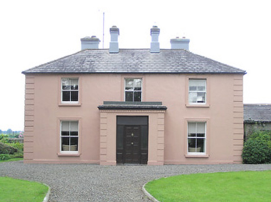
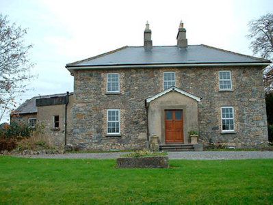
| Coolamber Manor [Cloonshannagh] | At the time of Griffiths Valuation in the early 1850s, Coolamber was held in fee by Major Blackall, when it was valued at £75. It is labelled "Cloonshannagh House" on the 1st edition OS Map but as "Coolamber Manor" on the later editions. The National Built Heritage Service suggests it was built c.1830 and significantly extended c.1880. It is still extant, having previously functioned as a rehabilitation facility. Extensive estate architecture also survives. |
![Photo of Coolamber Manor [Cloonshannagh]](https://landedestates.ie/storage/img/orig/3355.png)
|
| Lisryan | James Ennis was leasing this property from the Blackall estate at the time of Griffiths Valuation in the early 1850s, when it was valued at over £20. It is not labelled on any edition of the Ordnance Survey map, though a much-expanded building is shown on the 25-inch edition. The site is now occupied by a modern house. | |
| Moneyhoolaghan House | Benjamin Lloyd was leasing Moneyhoolaghan from the Blackall estate at the time of Griffiths Valuation in the early 1850s, when it was valued at £16. The National Built Heritage Service suggests the current house was built c.1880. It is still extant. |
|
| Coolamber | Philip O’Reilly was leasing this property from the Blackall estate at the time of Griffiths Valuation, when it was valued at almost £23. The property was associated with the Blackall family by whom, according to O'Brien, it was built c.1830. Later in the nineteenth century it came into the possession of the O’Reilly family. Towards the end of World War II it was, for a time, the home of Prince Ernest, Duke of Saxony. Since the early 21st century, it has been undergoing restoration and now serves as venue for occasional gardening courses. |
|
| Ballinree House {Longford) | Phillip Kiernan was leasing Ballinree House from the Moore O’Farrell estate at the time of Griffiths Valuation, when it was valued at £5. A larger house is shown on the 25-inch Ordnance Survey map of the early 20th century. A house and large farm occupy the site now. This house was associated with the Farrell family in the 18th century as local sources recall "Bonny Pat Farrell" a United Irishman killed at the Battle of Granard in 1798. | |
| Manor Mill House | William Cox was leasing this property from the Tuite estate at the time of Griffiths Valuation in the 1850s, when it was valued at £23 and included a mill. It is not labelled on the 1st edition six-inch Ordnance Survey map but appears as Manor Mill on the later 25-inch edition. It is no longer extant. | |
| Lissanure House | Lissanure House is labelled on the 25-inch Ordnance Survey map of the early 20th century. At the time of Griffiths Valuation in the early 1850s, the property at this site was occupied by William Green, leasing from the Tuite estate, when it was valued at £4. The National Built Heritage Service suggests that the current building replaced the earlier house in the 1850s. It is still extant but not used. |
|
| Clonwhelan | Richard White held this property in fee at the time of Griffiths Valuation when it was valued at £15. In 1814 Leet referred to it as the residence of Miss Godley. James Bond was the occupier at the time of the initial valuation in 1839 when it was valued at £12. It is still extant |
|
| Kilmore House (Westmeath) | At the time of Griffiths Valuation, Kilmore House was leased by Reverend Francis Kane from Reverend William Bowles and was valued at £10. The house is not visible on the 1st edition OS map but is labelled Kilmore House on the 25-inch edition. It is still extant and part of a farming enterprise. Lewis noted that the living of Kilmore was in the patronage of Fulke Greville in 1837. Reverend Francis Kane was afterwards rector of the parish of Fenagh, County Leitrim, from 1869 until his death in 1882. He had previously been vicar in the parish of Russagh, nearby to Street, County Westmeath, 1848-1855. | |
| Grange Hall | The building at this site on the first edition OS map is named Orange Hall and Grange Hall on the 25 inch map with a courtyard and laid out gardens. At the time of Griffith’s Valuation (publ. 1854) Owen Evers or Eivers owned and occupied the house, valued at £16. This property belong to Eugene Eivers in 1870, who owned 107 acres of land in the area at the time. The Eivers were still resident in 1906 and 1911 and the house remains a well maintained residence. |
|
| Ballysallagh House | Ballysallagh house is not marked on first edition OS map. It is a three-bay two-storey late-Georgian-style farm house, built about 1850. At the time of Griffith’s Valuation (publ. 1854) it was occupied by Christina McCormick, who held the house valued at £11 from William Longworth. It is still in use as a residence. |
|
| Baronstown | Baronstown was a large mansion in an extensive demesne on the western shore of Lough Iron, as shown on the first OS map, with many features such as a temple, summer house etc. Described by the National Built Heritage Service as an important late eighteenth-century Palladian villa with two storey wings, it was associated with the Malone Family/Lord Sunderlin. Taylor and Skinner noted it as a Malone property in 1777. Lord Sunderlin was resident in 1814. Following the death of Richard Malone in 1837 his sister Alicia who had married Henry O’Connor of Mount Pleasant, King’s County (Offaly) succeeded to the Baronstown and Shinglis estates. O’Brien writes that the building was burnt twice and rebuilt. The first time in 1889 and the second time in 1903 when it was replaced by a large Tudor villa to designs by James Franklin Fuller. In 1906 it was valued at £70 and was occupied by Colonel John R Malone who held it with 943 acres of untenanted land. Demolished by the Land Commission in the 1920s, it is now a greenfield site. |
|
| Oran Vale | Located directly north of Ballynacarrigy, Oran Vale is named on the first edition OS map and was occupied by J Irwin in 1837. Valued at £15 it was unoccupied at the time of Griffith’s Valuation (publ. 1854) while the immediate lessor was Thomas William West who held the property from Alicia O’Connor Malone. The house is not named on the 25 inch map and is now a ruin. | |
| Willybrook/Willifield | This house is named Willybrook on the first edition OS map and as Willifield on the 25 inch map. Valued at £12 at the time of Griffith’s Valuation (publ. 1854), it was occupied by Joseph Evers who held it from Alicia O’Connor Malone (in Chancery) and remains a well maintained residence. |
|
| Kill House | Kill house marked on first edition OS map and the 25 inch map is located a short distance west of Sonna. At the time of Griffith’s Valuation (publ. 1854) it was valued at £17, occupied by Maria McCormick and held from George Thompson. It appears to be still extant with courtyard outbuildings. | |
| Rath House | Rath House, was the home of J West in 1837 and of Thomas West at the time of Griffith’s Valuation (publ. 1854), when the buildings, including a corn mill, were valued at £34 and held from Alicia O’Connor Malone. In 1906 the mansion house of Rath valued at £30 was in the occupation of Colonel John R Malone and was held with 62 acres of untenanted land. The census records would suggest that the local rector Rev Venn was actually resident. The house is now demolished. | |
| Tristernagh House | Described as an imposing and dramatic ruin with an interesting and varied history Tristernagh was originally an important Augustinian Abbey, founded c. 1200 by Geoffrey de Costentin (boi). After the dissolution of the monasteries and abbeys it was granted to the Piers Family, Elizabethan settlers. In 1783 Sir William Pigot Piers turned part of the building into a residence, which is named as Tristernagh House on the first edition OS map. It was unoccupied in 1814. A new house/cottage was built to the north of the abbey in the early nineteenth-century which is marked on the first edition OS map (N332 616). It is not clear which of these houses Lewis is referring to as the seat of Sir John Piers Bt in 1837. The 25 inch map of the early 20th century named this later building as Tristeragh House, while the original Tristeragh House at the abbey site was a ruin. Woods writes that the ‘late J Eivers Esq, J.P., lived for years in the cottage built by the late Sir John Piers’ while the mansion built by Sir Pigot William Piers in 1783 was ‘a crumbling ruin’. At the time of Griffith’s Valuation (publ. 1854) James Evers was recorded as the occupant of a house at Tristernagh valued at £10 held from Hamilton Geale. Shepherd Patrick Garry with family members was living here in 1901 and 1911. They held the house from Colonel John R Malone. The house is still extant. |
|
| Ardglass House | This house was rebuilt in the style of an Italianate Villa post Griffith’s Valuation, possibly incorporating the fabric of an earlier house on the same site. The original Ardglass House was the home of a Major A. P. Bond in 1837. Valued at £13.15 at the time of Griffith’s Valuation (publ. 1854), it was occupied by the representatives of A P Bond who held it in fee. The present house was in the ownership of William Perry Bond JP, in the 1880s. The house has had various owners in the 20th century and was for sale in 2017, see https://www.businesspost.ie/article/high-class-at-ardglass-co-westmeath/ | |
| Newpark Lodge | Newpark Lodge named on both the first edition OS map and the 25 inch map. Occupied by James Auchmuty JP in 1837 and at the time of Griffith’s Valuation (publ. 1854) when he held the house valued at £10 from the representative of A P Boyd. Now a modern building located at the site situated on the main road from Mullingar to Edgeworthstown. Newpark Lodge was for sale in 2021. | |
| Sonna | Set in a substantial demesne as shown of the first edition OS map, the building is slightly altered in shape from this map to the 25 inch map. The house was a three-storey, seven-bay mid-18th century Palladian style mansion. It was the home of the Tuite family and remained as such until it was burnt in 1921. Described in 1837 by Lewis - ‘Sonna for upwards of six centuries, the seat of the Tuite family, is at present the residence of Hugh Morgan Tuite… the house is a light and elegant building, in a well planted demesne’. O’Brien gives a detailed account of the family. The estate consisting of 638 acres was sold to the Land Commission in 1928. See https://www.tuites1.com/424198848.html |
|
| Daramona House | The National Built Heritage Service suggests this house was built c.1850 by the Wilson family. In later times there was also an observatory at the site. At the time of Griffiths Valuation, it was held in fee by William Wilson and valued at over £28. In 1906 it was owned by John Wilson and valued at almost £73. It is still extant though apparently not in use. |
|
| Crossea | John O’Byrne [O’Beirne] was leasing this property from the Ecclesiastical Commissioners at the time of Griffiths Valuation in the early 1850s when it was valued at over £10. The original Valuation Office books record a valuation of £12 in 1839. The Ordnance Survey Name Books suggest the townland was in the hands of Reverend Mr. Oliver in the mid-1830s. A large farm is still extant at the site. | |
| Irishtown | Irishtown is named on the first edition OS map and the 25 inch map. In the late 1770s it was the home of Johnston. The Banon/Bannons lived here in the 19th century. Lewis records J Banon as resident in 1837 and Christopher J Bannon was the occupant at the time of Griffith’s Valuation (publ. 1854). He held the house valued at £15 from William H Magan. The Banons were still living at Irishtown at the time of the 1901 and 1911 censuses. The house was demolished in the 1960s but outbuildings remain. | |
| Wilson's Hospital | Wilson's Hospital School erected on the summit of a hill, was founded by a trust set up by Andrew Wilson of Piersfield [Piercefield]. The National Built Heritage Service records that Wilson stated in his will of 1724 that in the event of there being no direct male heirs to his estate that it, and all its profits, be transferred to the Church of Ireland hierarchy and used to build a hospital for aged Protestant men and a school for poor Protestant boys. This was the case by 1743 and the school was completed in 1761. ‘Wilson's Hospital is one of the finest and most sophisticated mid-Georgian buildings constructed outside of Dublin. Its design has been attributed John Pentland, a noted architect of his day, and it is built in the style of a Palladian country house’ (boi). It is a seven-bay two-storey building which was valued at £90 at the time of Griffith’s Valuation (publ. 1854) and continues to function as a secondary co-educational boarding school today. | |
| Lackan | Lackan house is marked but not named on the first edition OS map. It was a two-storey, three-bay house, the home of the Delamare family, long associated with the Multyfarnham area. The Taylor and Skinner maps of the late 1770s include reference to Delamar at Lacken. In 1837 Lackan was the seat of Mrs Delamere. It was unoccupied at the time of Griffith’s Valuation (publ. 1854) when valued at £17. The immediate lessor was Patrick J Murphy. A number of Delemere families were still resident in the townland in 1901. This house has been demolished. | |
| Rathbennett House | Rathbennett House, formerly known as Farra House, originally functioned as Bunbrosna Charter School. Built c.1758 with a bequest from the will of the Rev. William Wilson, the nephew and heir of Andrew Wilson, the benefactor of Wilson's Hospital. Farra Charter School is recorded by Lewis in 1837 and was still recorded as a charter school with offices at the time of Griffith’s Valuation (publ. 1854) when the building was valued at £30. It was held by the trustees of Wilson’s Hospital in fee. Sometime later it became a private residence. Occupied by Thomas Cartret Foster in 1901 and 1911, this house remains a family home. |
|
| Ballinacloon | Ballynaclonagh, named on the first edition OS map as Ballynaclonagh and on the 25 inch map as Ballinacloon and extended. No longer extant, demolished c 1930. Complex of single and two-storey outbuildings on L-shaped plan survive. Ballynaclonagh was the residence of Edward Murphy in 1814 and P. E. Murphy in 1837. Griffith’s Valuation (publ. 1854) records Patrick E Murphy as the occupier holding the property valued at £33.5 in fee. Patrick Delamere, coachman to Captain Murphy, was resident with his wife in 1901. Valued at £45.5 in 1906 and in the possession of Captain Laurence Murphy. The Delameres had three children by 1911 and were resident holding the property from Mrs Sarah Murphy. | |
| Soho (Multyfarnham) | Soho, an early 19th century three-bay two-storey house, is named on the first edition OS map. Inherited by Lattin Fitzgerald, a younger son of Catherine Nugent of Donore and her husband Pierce Fitzgerald, who occupied the house in 1814. At the time of Griffith’s Valuation (publ. 1854) it was the residence of Peter Nugent Fitzgerald, valued at £15.15 and held from Sir Percy Nugent of Donore. The house was occupied by Mrs Margaret Fitzgerald’s gardener Edward Fay in 1901 and by Colonel Edward Irwin and family in 1911. Soho is still a family home. |
|
| Mount Murray | Mount Murray House is situated facing the western shore of Lough Owel and is named on both the first edition OS and 25 inch maps. The Murray family have been resident here since the mid-17th century and remain in residence today. The present house is a five-bay two-storey over basement country house, built about 1780 and remodelled c.1820 with the addition of a semi-circular bow to the southeast façade (boi). It was built by Alexander Murray in the late eighteenth-century to replace an earlier Murray house or castle close to the same site. Occupied by Alexander Murray in 1814 and 1837 and by Henry Murray at the time of Griffith’s Valuation (publ. 1854) who held the house valued at £46 in fee. William Murray was resident in 1906. |
|
| Ardagh House (Longford) | In 1837 Lewis had identified Ardagh House as the property of G.R. Fetherston. In 1814 Leet recorded it as the seat of Sir T. Fetherston, MP. At the time of Griffiths Valuation in the 1850s it was owned by his representatives and valued at £46. The National Built Heritage Service suggests the house was built c.1730 and altered twice in the nineteenth century. It was partially damaged by fire in 1922 and again in 1948. In the later twentieth century it served as a domestic economy training facility operated by the Mercy Sisters. Together with numerous estate buildings it is still extant though not currently in use. |
|
| Colehill (Longford) | The Ordnance Survey Name Books noted that Colonel White was the proprietor of the townland of Colehill. The house of the same name was leased by a Mrs. Power to Captain Robert N. Bolton at the time of Griffiths Valuation in the 1850s, when it was valued at almost £18. The Valuation Office House books of the 1840s record Thomas Lennon as the occupier at that time. The National Built Heritage Service dates the original part of this house to the 1760s with later additions in the mid 19th century. It indicates that the house was associated with the Nugent family. It is still extant and occupied. |
|
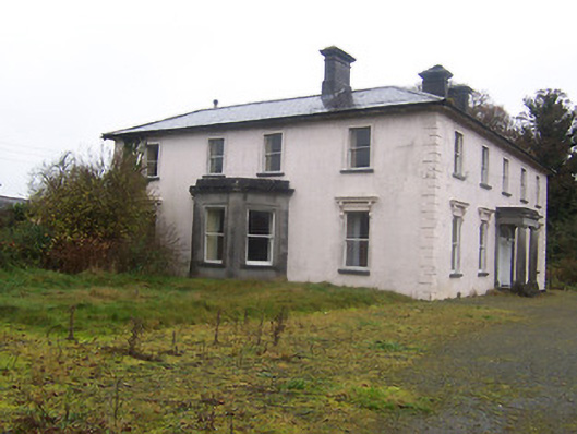
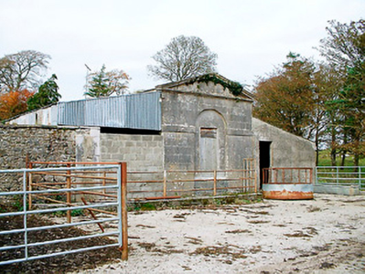
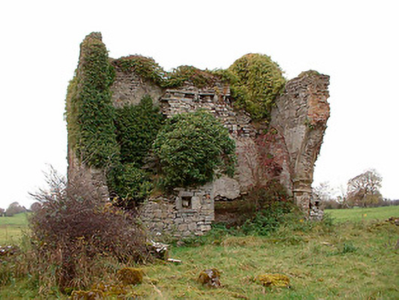
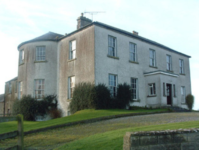
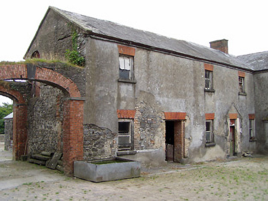
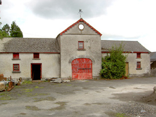
| Castlewilder [Cloghdoo House] | Richard P. O’Reilly, MD, held this property in fee at the time of Griffiths Valuation in the early 1850s, when it was valued at £30. On the 1st edition Ordnance Survey map it is labelled Cloghdoo House but as Castlewilder on the 25-inch edition of the early 20th century. The Ordnance Survey Name Books note that the townland at that time (1835) was the property of Mr. Wilder. In 1814 Leet referred to 'Castlewilden' as the seat of John Mangan. The National Built Heritage Service suggests the house and its complex of estate buildings was built in the 18th century but modified in the 1880s. |
![Photo of Castlewilder [Cloghdoo House]](https://landedestates.ie/storage/img/orig/3403.png)
|
| Foxhall (Ballymahon) | Richard M. Fox held this property in fee at the time of Griffiths Valuation in the 1850s, when it was valued at £40. The original valuation also noted it as his property in 1839 with a valuation of £39. In 1906 it was owned by the representatives of R.E. Fox. The Ordnance Survey Name Books mention that the demesne contained 38 acres of woodland in the mid-1830s. Leet referred to it as the residence of Richard Fox in 1814. The National Built Heritage Service suggests that the house at Foxhall was demolished in 1946. Estate architecture, including the stables, survives |
|
| New Port (Ballymahon) | At the time of Griffiths Valuation in the early 1850s, Patrick Ross was leasing this property from the Fox estate, when it was valued at almost £9. In 1814 Leet referred to it as the residence of J, Molloy. The Ordnance Survey Name Books mention it as a gentleman's residence belonging to Mr. Fox. The house is labelled New Port on the 1st edition Ordnance Survey map but does not appear on subsequent maps and is no longer extant. | |
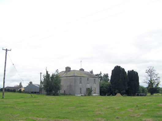
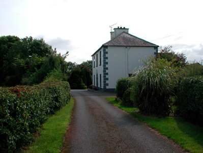
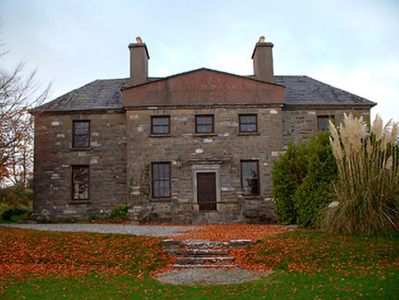
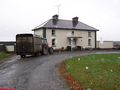
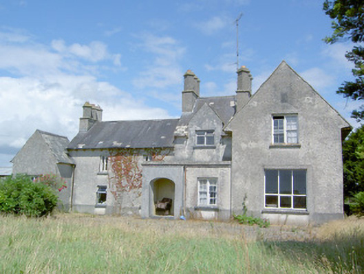
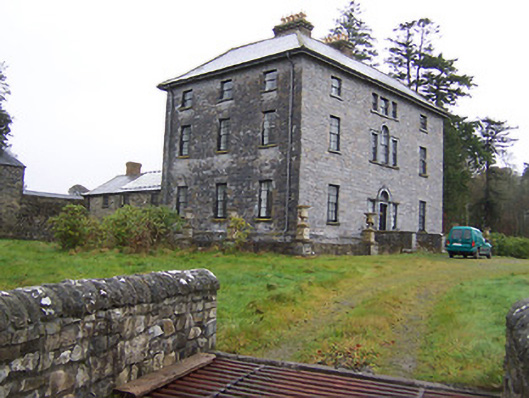
| Newtown House [Newtown Lodge] | Robert Hagerty was leasing this property from the Fox estate at the time of Griffiths Valuation in the early 1850s. The house at the site is labelled Newtown Lodge on the 1st edition Ordnance Survey map. The Ordnance Survey Name Books referred to this as a 'farm house' in the 1830s. A different house at the site is named as Newtown House on the later editions, the name by which it is still known. The National Built Heritage Service suggests the original house was built c.1810. It is extant and well-maintained. |
![Photo of Newtown House [Newtown Lodge]](https://landedestates.ie/storage/img/orig/3406.png)
|
| Sleehaun House | This property is not shown on the 1st edition OS map but is labelled Sleehaun Ho on the 25-inch edition of the early 20th century. It was occupied by Michael Ledwidge at the time of Griffiths Valuation in the early 1850s when it was valued at £13 and leased from the Fox estate. The National Built Heritage Service suggests it was built c.1850. It is still extant. |
|
| Treel House | William Atkinson was occupying Treel House at the time of Griffiths Valuation in the 1850s, when it and the adjacent mill were valued at £28. The National Built Heritage Service suggests the house was built c.1830. In 1839 the original Valuation Books, however, stated that at that time no house in the townland had a valuation of greater than £5 suggesting that Treel House was enlarged after that date. The Ordnance Survey Name Books noted in 1835 that the townland was then the property of Mr. Fox. Treel is still extant though not in use. |
|
| Knockagh House [Hermitage] | Francis Kenny was leasing this property from the Robinson estate at the time of Griffiths Valuation in the early 1850s, when it was valued at almost £12. On the 1st edition Ordnance Survey map it is labelled Hermitage. The Ordnance Survey Name Books refer to “the gentleman’s seat called Hermitage in this townland”. On the 25-inch edition of the early 20th century it is labelled “Knockagh House – in ruins”. | |
| Richmount Hill | John Higgins, MD, was leasing this property from Jane Richardson’s estate at the time of Griffiths Valuation in the 1850s, when it was valued at over £15. In 1814 Leet referred to it as the seat of Auchmuty Richardson. The National Built Heritage Service suggests that this house was built c.1720. It is still extant and occupied. |
|
| Sunfield House | George Gamerson was leasing this property from the King Harman estate in the 1850s when it was valued at £12. The valuers' original valuation, which also includes a description of all buildings on the site, was over £20. The house is not named on the 1st edition OS map but is labelled Sunfield House on the 25” ed. A substantial farm occupies the site including the original buildings |
|
| Newpass | Griffiths Valuation notes the owners of Newpass as Elizabeth Westby and the representatives of Sir. G. Fetherson. Elizabeth Westby was the wife of William Westby and the daughter of George B. Whitney of Newpass. The house was unoccupied in the early 1850s and valued at £35. The National Inventory of Architectural Heritage suggests it was built c.1775 by the Whitney family, probably on the site of an earlier house. Taylor and Skinner noted it as a Whitney property in 1777. O'Brien states that Colonel Whitney first purchased the Newpass estate in 1670. In 1906 it was owned by Major E. Henry Fetherston Whitney and valued at £43. It is still extant. The estate also owned property in the nearby village of Rathowen. |
|
| Kildevin | Moses Sproule was leasing this property from William H. Little at the time of Griffiths Valuation in the early 1850s, when it was valued at £36. O'Brien states that a name plaque at the property indicates the building of the house by Robert Sproule in 1833. It was the residence of the Sproule family until the later part of the 19th century when it was acquired by Meredith Johnston and by the Tyndall family. It is still extant and has been offered for sale on a number of occasions since 2000. |
|
| Kilmore House (Moygoish) | At the time of Griffiths Valuation, Kilmore House was leased by Reverend Francis Kane from Reverend William Bowles and was valued at £10. The house is not visible on the 1st edition OS map but is labelled Kilmore House on the 25-inch edition. It is still extant and part of a farming enterprise. Reverend Francis Kane was afterwards rector of the parish of Fenagh, County Leitrim, from 1869 until his death in 1882. He had previously been vicar in the parish of Russagh, nearby to Street, County Westmeath, 1848-1855. | |
| Edgeworthstown House | The Edgeworth family had been settled at Edgeworthstown in the parish of Mostrim, County Longford, since the 17th century. At the time of Griffiths Valuation in the 1850s, Fanny Edgeworth was leasing the property from Charles Edgeworth, when it was valued at £45. [It is likely that Fanny was his stepmother} The National Built Heritage Service suggests the present building began in 1725 but had several rounds of modifications subsequently. In more recent years it has served as a health care facility. |
|