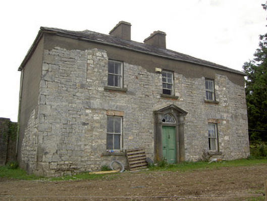
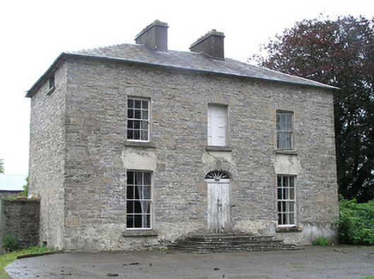
Woodville (Granard)
Houses within 15km of this house
Displaying 47 houses.
Houses within 15km of Woodville (Granard)
Displaying 47 houses.
| House name | Description | |
|---|---|---|
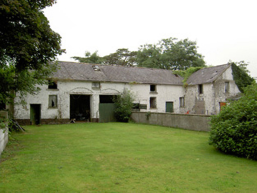
| Cloghlough | At the time of Griffith's Valuation, William O'Brien was leasing a property valued at £8 at Cloghlough, barony of Carrigallen, from the estate of John King, which was in Chancery. Substantial farm buildings exist at this site. | |
| Ballinlough House | Thomas Gosslin was the immediate lessor of Ballinlough House at the time of Griffiths Valuation in the early 1850s, when it was valued at £18. In 1814 Leet referred to it as the residence of J.C. Irwin. In 1835 the Valuation Office books mention Edward Irwin as the occupier. The building is still extant but no longer in use. |
|
| Moatfarrell House | At the time of Griffiths Valuation in the early 1850s, Moatfarrell was leased by William F. Ryan from the estate of Edward Murphy when it was valued at £18. In the early 1840 it had been occupied by Laurence O'Rourke. The National Built Heritage Survey suggests the extensive outbuildings were constructed in the mid-nineteenth century and notes that the property was occupied by the Fegan family in the 1890s. The building is still extant. | |
| Bracklagh | The house faced Bracklagh Lough, very close to the border between counties Cavan and Longford. It is marked on the first edition six inch Ordnance Survey map (publ. 1837). In the mid-19th century it was inhabited by Captain Mark Ker and held from the Ecclesiastical Commissioners. The rateable valuation was £15. Home of Matthew William Webb and family in 1901. A building is still extant on this site. | |
| Lakeview (Garrison) | A house on the Farnham estate, named on the first edition Ordnance Survey map (publ. 1837), valued at £11.10.0. in the mid-19th century when occupied by Edward Soren and held from David Kellett. | |
| Rock House (Cavan) | Marked on the first edition Ordnance Survey map (publ. 1837). In the 1850s, this house was occupied by the Reverend Matthew Webb and held from George Wilton. It had a rateable valuation of £21. It is now the centre of a farming complex. | |
| Kill | Ambrose Leet records Kill, Mount Nugent, as the residence of George Lenauze. Kill House, located on the estate of the Bishop of Kilmore, is named on the first edition 6 inch Ordnance Survey map (publ. 1837). At this time there were laid out gardens and extensive plantations within the demesne grounds. The buildings at Kill House are reduced in size on the later 25 inch map. In the 1850s Garrett Keogh was the occupier holding the property valued at £5 from John Orpen. This house is no longer extant. | |
| Riverview/Cloggy House | River View was situated on the bank of the River Erne. It was obviously associated with linen making in the early 19th century as beetling and bleaching mills are both marked near the house on the first edition six inch Ordnance Survey map (publ. 1837). A corn mill is also shown nearby. The Faris family were resident in Cloggy from at least 1832 when Alexander Faris is mentioned in the Tithe Applotment Books. In the mid-19th century William Faris was resident holding the buildings valued at £15 from Cosby Thomas Nesbitt. Alexander Faris/Ferris, a farmer and his family were living in Cloggy at the beginning of the 20th century. This house has been modernised and still retains a fine range of outbuildings. | |
| Kilshruley House | At the time of Griffiths Valuation in the early 1850s, Major T.N. Edgeworth held this property in fee when it was valued at £20. It is labelled Kilshruley Manor on the 25-inch map of the early 20th century. It has since been demolished. A memorial stone at the site indicates that a castle belonging to the Adair family previously stood near the site. | |
| Laurel Bank/Holly Bank | This house, originally known as Laurel Bank, is named on the first edition six inch Ordnance Survey map (publ. 1837). It is shown in a demesne which included an old bleach mill and a corn mill and kiln. It is believed to have been built by a mill owner in the 18th century. Griffith’s Valuation records William Norton as the occupant holding the property valued at £8.10.0. from the Earl of Gosford. The house is called Holly Bank on the 25 inch map. Altered and added to in the 20th century it continues to be a residence. | |
| Gartinadress House | In 1814, Charles Veaitch was the resident at Gortin-ardrass. This house is named on the first edition six inch Ordnance Survey map (publ. 1837). Although having advertised Gartinardress for sale in 1850 William Young was the owner and occupier at the time of Griffith’s Valuation when the property was valued at £15 for rates. By the early 20th century the Armstrong family were occupying Gartinardress, although in 1906 William A. K. Young is recorded as occupier of 228 acres of untenanted land and the mansion house. This house is no longer extant and the site is part of a forestry area. A house known as Lakeville was also located in the townland of Gartinardress. Leases in the National Library record Lakeville as the home of Richard Young in the 1820s. It was described as ‘in ruins’ on the 25 inch map. | |
| Tully House (Killashandra) | Richard Young of Tully 1808, see GO MS. Richard Young and his wife Bridget Nugent Reynolds later lived at Fort Lodge, on the outskirts of Cavan town. In 1814, Mr R.Y. Reynolds was resident at Tully, Crossdoney. Major Randal Stafford of Tully House, Crossdoney, is listed as a subscriber to Lewis ‘Topographical Dictionary’ (1837). In the 1850s this house was occupied by William Magee who held it from the representatives of Hugh Walsh. The Douglas family were resident at the beginning of the 20th century. | |
| Bruce Hall | Thomas Hinds of Prussia Street, Dublin and previously of Bruce Hall, county Cavan, died in 1794. Henry B. Wilson was resident at Bruice-hall, Arva, in 1814. Bruce Hall was the home of John Warren in the mid-19th century. John Warren married Isabella, daughter of Captain James Blakely of Lake View, county Cavan, in 1856 (Anglo-Celt, 28 August 1856). He held Bruce Hall from Robert Burrowes and it was valued at £10 for rates. | |
| Bellville | The Fleming family were known to be at Bellville from the early 18th century. The house is named on the first edition six inch Ordnance Survey map (publ. 1837) and located facing two forts in a sizable demesne. Belville was the home of A. Fleming in 1814 and of Captain A. Fleming in the 1830s. By the 1850s, the occupant was Jane Kenny who held the property valued at £7 from Major General Fleming. At the beginning of the 20th century Bellville was the home of the Meikle family, originally from Scotland. It is still extant. | |
| Corstruce House | A house located on the outskirts of Bellananagh and near a corn mill. It was situated on part of the Fleming estate and was occupied by William Pollock in the mid-19th century and was in the possession of Thomas Brady in the early 20th century. A modern house now occupies this site. | |
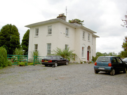
| Lismore Lodge | Built as the agent’s house in the Nesbitts’ Lismore Castle demesne close to the village of Crossdoney. Lismore Lodge is named on the first edition six inch Ordnance Survey map (publ. 1837). It was the home of William Tatlow in the mid-19th century, when the buildings were valued at £20. Occupied by the family of Thomas Cosby Burrowes at the beginning of the 20th century. His mother Mary Anne Burrowes had succeeded to the Lismore estate in 1886 following the death of her brother Alexander Nesbitt. Under boundary changes at the end of the 19th century the location of the Lodge was changed to the townland of Lismore Demesne and it was valued at £32 for rates in 1906. In the mid-20th century it was a Lucas-Clements home. This house is extant but unoccupied. |
|
| Drumcarban | Bence Jones describes Drumcarban as a late 18th century house of 3 storeys and 3 bays. It was the home of the Bell Booth family in the 19th century. George Thomas Bell Booth was resident in the 1830s and 1840s until he was murdered in 1845. Robert Booth Bell was the owner and occupant at the time of Griffith’s Valuation. This house was occupied by Annie Sheridan in 1901, in 1906 by Michael Sheridan when it had a rateable valuation of £22.5.0. and is still extant. | |
| Lismore Castle | An early 18th century house, possibly designed by Sir Edward Lovett Pearce (Bence Jones). Named on the first edition six inch Ordnance Survey map (publ. 1837), it was valued at £12 for rates in the mid-1850s. It was a Nesbitt family home until the 1880s when inherited by the Burrowes family and passed from them by marriage to the Lucas Clements in the 1920s. However the house was marked as ‘in ruins’ on the 25 inch map. Bence Jones records that it was later demolished and that the Lucas-Clements resided in the agent’s house nearby Lismore Lodge. | |
| Rockville (Crossdoney) | Named on the first edition six inch Ordnance Survey map (publ. 1837), Rockville was located on the Nesbitt estate to the north east of Lismore Castle, on the outskirts of Crossdoney. In the 1830s it was the home of John C. Tatlow and in the 1850s of Samuel Moore, when the buildings were valued at £20 for rates. Occupied by Dr John Stirling Greer and his wife in 1901 and held from Thomas Cosby Burrowes. Another medical family named Hallowes was resident in 1911. Apparently still extant and occupied. | |
| Lake View (Scrabby) | Lake View in the townland of Bernyhill (212 acres) was the home of the McManus family. In the mid-19th century Eugene McManus held the property, valued at £11.10.0. in fee. He owned the townland of Bernyhnill in 1876. Eugene Mc Manus, aged 39, was resident at Lake View in 1901 and in 1911. A house surrounded by farm building is still extant at this site. | |
| Dalystown House | Francis Tuite was leasing this property from the Thornton estate at the time of Griffiths Valuation, when it was valued at over £10. In the 1870s it was recorded as the address of Laurence Reynolds. This property is labelled Rockfield House on the 1st edition Ordnance Survey map but as Dalystown House on the 25-inch map of the early 20th century. In 1906 it was still in the ownership of Laurence Reynolds and valued at almost £23. The National Built Heritage Service suggests 1820 as a building date for the surviving farmyard complex. Dalystown House has been demolished. |
|
| Castle Nugent | At the time of Griffiths Valuation in the 1850s, William Webb was leasing this property from Arthur Kingston, when it was valued at £18. It was also recorded by Lewis as the seat of W. Webb in 1837. IN 1814 Leet referred to it as the residence of John West. The National Built Heritage Service suggests it was built c.1775. It is still extant but disused. |
|
| Cornadrung Cottage | In 1906 the report on Untenanted Demesnes notes a property at Cornadrung in the possession of Edward Fitzgerald and valued at over £10. This house is labelled Cornadrung Cottage on all editions of the Ordnance Survey map. It appears to have begun as a small property, possibly a hunting lodge on the shores of Lough Gowna which was enlarged in the latter part of the 19th century. In the 1870s Cornadrung was recorded as the address of Mrs. Sarah Hughes. Family history sources suggest it was later owned by the Cole family. The site is now occupied by a modern house. | |
| Derrycassan House | John Dopping held this property in fee at the time of Griffiths Valuation in the early 1850s, when it was valued at £36. Burke suggests it had been a D’Arcy property until the marriage of Alice D’Arcy to Anthony Dopping in the 18th century. It was in the ownership of Capt. J.D.L. Hepenstal and valued at £50 in 1906. Derrycassan House was acquired by the Forestry Service. The house was demolished and some of the stone used in the construction of St. Columba’s RC church not far away. Other estate architecture remains and there are woodland walks in the estate. | |
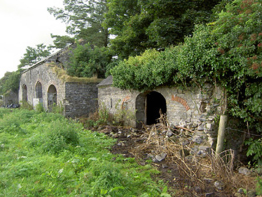
| Currygrane House | In 1837 Lewis noted “Curraghgrane” as the seat of W.L. Galbraith. At the time of Griffiths Valuation in the 1850s, William F. Ryan was leasing this property from the Misses Bond, when it was valued at £20. In 1906 it was valued at over £47 and in the ownership of James Wilson. This was the birthplace of Field Marshal Sir Henry Wilson, Britain’s chief military advisor at the end of WWI, assassinated in London in 1922. Currygrane House was burned a few weeks later and subsequently demolished. Extensive outbuildings remain at the site. |
|
| Garvagh House | At the time of Griffiths Valuation in the 1850s, Robert Grier held this property in fee, when it was valued at £20. In 1837, Lewis had referred to “Lakeview” as the seat of R. Grier. In 1906 James Wilson was recorded as the owner and the property was still valued at £20. It was later demolished. | |
| Vicarsfield | Reverend Theodore O’Moore was leasing this property from Robert Grier at the time of Griffiths Valuation in the early 1850s. It is now known as Vicarsfield House. The National Built Heritage Service suggests it was built in the 1820s. |
|
| Fernsborough | Thomas Gosselin was leasing this property from William Shirley Ball’s estate at the time of Griffiths Valuation when it was valued at £25. In 1837 Lewis noted “Fernsboro” as the seat of A. Burrows. It was also recorded as the seat of Alexander Burrowes by Leet in 1814. Fernsborough is no longer extant. Hussey de Burgh noted Thomas Gosselin as the proprietor of almost 300 acres in County Longford in the 1870s. | |
| Moorhill House | At the time of Griffiths Valuation in the 1850s, John Simpson was leasing this property from Major Blackall’s estate, when it was valued at £26. It is still extant. |

|
| Lisryan | James Ennis was leasing this property from the Blackall estate at the time of Griffiths Valuation in the early 1850s, when it was valued at over £20. It is not labelled on any edition of the Ordnance Survey map, though a much-expanded building is shown on the 25-inch edition. The site is now occupied by a modern house. | |
| Lissard House | John L. O’Farrell was leasing this property from the Adair estate at the time of Griffiths Valuation in the 1850s, when it was valued at £35. In 1837 Lewis noted is as the O’Farrell seat also. Edward O’Farrell is noted as a property owner in Lissard in the Tithe Applotment book in 1825. Lissard survived into the twentieth century but is no longer extant. | |
| Frankford House | Reverend Patrick Ratigan was leasing this property from Edward McEvoy’s estate at the time of Griffiths Valuation in the 1850s, when it was valued at £14. It held the same valuation when first valued in 1839. At that time it was occupied by Nathaniel O'Reilly. It is not extant now. | |
| Mossvale | The Ordnance Survey Name books of the 1830s noted Mossvale as the seat of J. Barber. At the time of Griffiths Valuation. in the early 1850s, it was being leased from the Hamilton estate by William Lewis, when it was valued at £20. It was later demolished but the stables and other estate architecture survives. |
|
| Erne Head | In 1837 Lewis referred to “Kilrea” as the seat of H. Dopping . Henry Dopping held this property in fee at the time of Griffiths Valuation in the 1850s when it was valued at £15. It is labelled Erne Head on the 25-inch Ordnance Survey map of the early 20th century. The house at Culray was the property of Reverend Francis Dopping in 1906 when it had a valuation of almost £18. It is no longer extant. | |
| Fernmount (Granard) | John B. Kirk was leasing this property from Richard Greville’s estate at the time of Griffiths Valuation in the 1850s, when it was valued at over £10. It is not named on the 6” OS map but a more substantial house is labelled Fernmount on the 25” map of the early 20th century. It is still extant. | |
| Higginstown House (Granard) | At the time of Griffiths Valuation in the early 1850s, Francis Tuite was leasing this property from Richard Greville’s estate when it was valued at £15. It is labelled Higginstown House on the 25” edition OS map of the early 20th century. The site is now occupied by large farm buildings. {Francis Tuite and his family are buried in the Church of Ireland church yard in Granard, see https://www.igp-web.com/IGPArchives/ire/longford/cemeteries/granard.htm ] | |
| Killasona House | Killasona House was occupied by Owen McCormack at the time of Griffiths Valuation in the early 1850s when it was valued at £10. It was leased from Richard Greville’s estate. McCormick was recorded as the owner of over 400 acres in County Longford in the 1870s. In 1906 it was owned by Richard Davoron and valued at over £17. It is still extant but disused. |

|
| Cloonfin House | John Thompson held this property in fee at the time of Griffiths Valuation in the early 1850s, when it was valued at £40. It has been demolished but a number of estate buildings survive. | |
| Creevy House (Longford) | George Dobbyn was leasing this property from the Maude estate at the time of Griffiths Valuation in the early 1850s when it was valued at £20. It is still extant. |

|
| Toneen Lodge | At the time of Griffiths Valuation in the early 1850s, Nathaniel Callwell held this property in fee when it was valued at £25. A house labelled Toneen lodge is shown on the 1st edition Ordnance survey map at N343782. It is described as a small house in the Ordnance Survey Name Books. The current house, situated a short distance away, is labelled Toneen Lodge on the 25-inch edition of the early 20th century and is still extant. |

|
| Crowdrumin Lodge | At the time of Griffiths Valuation in the early 1850s Patrick Mannion was leasing this property from Samuel Galbraith’s estate when it was valued at just over £3. A more substantial property, labelled Crowdrumin Lodge, is shown on the 25-inch Ordnance Survey map of the early 20th century. It has been replaced by a modern house. | |
| Ballinalee | Henry Reynolds was leasing this property from Reverend George Moore at the time of Griffiths Valuation in the early 1850s, when it was valued at over £15. It is possibly the building formerly in use as a Masonic Hall in the village and which the National Built Heritage Service suggests was converted to other uses in the 1840s. This building is extant but derelict. |
|
| Whitehill House (Granard) | In 1837 Lewis referred to Whitehill House as the seat of H.B. Slator. At the time of Griffiths Valuation in the 1850s, Henry B. Slator was leasing Whitehill from Mrs. Fearon, when it was valued at £18. It is no longer extant. | |
| Cartroncar House | Richard Taylor was leasing this property from Thomas Bond’s estate at the time of Griffiths Valuation, when it was valued at £25. In 1835 James Bond was recorded by the valuers as the occupier and the house had a valuation of £32. The Ordnance Survey Name Books note the existence of the house and demesne of Cartroncar in the townland, 'the seat of J.W. Bond'. It is still extant but disused. |
|
| Tully (Granard) | A steward’s house owned by Willougby Bond was located at Tully and valued at £15 at the time of Griffiths Valuation in the 1850s. The National Inventory of Architectural Heritage suggests this site had a long history dating back to an O'Farrell castle in the 17th century and later occupied by Newcomen and Wilson families before becoming part of the Bond estate. The Ordnance Survey Name Books mention that it was part of Major Bond's demesne with 'much old timber about the place'. Buildings still exist at this site. | |
| Farraghroe House | Willoughby Bond held this property in fee at the time of Griffiths Valuation in the early 1850s when it was valued at £55. Lewis had also referred to ‘’Farra’’ as his seat in 1837. In 1905 it was owned by James W. Bond and valued at £67. The house was demolished in the 20th century but much estate architecture, including the Steward’s House, remains. |

|
| Millbrook (Granard) | Patrick Flynn was leasing this house and milling complex from the Greville estate at the time of Griffiths Valuation in the early 1850s, when it was valued at over £13. |