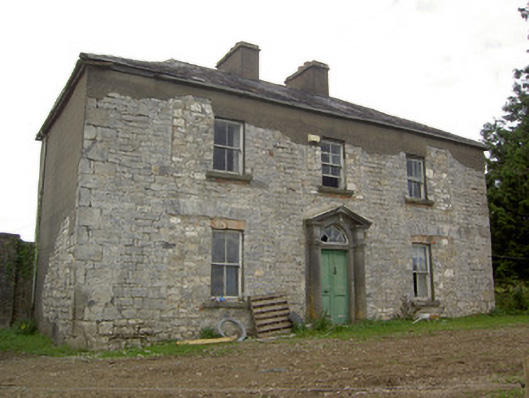
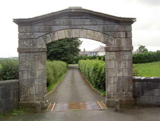
Woodville (Granard)
Houses within 10km of this house
Displaying 13 houses.
Houses within 10km of Woodville (Granard)
Displaying 13 houses.
| House name | Description | |
|---|---|---|
| Ballinlough House | Thomas Gosslin was the immediate lessor of Ballinlough House at the time of Griffiths Valuation in the early 1850s, when it was valued at £18. In 1814 Leet referred to it as the residence of J.C. Irwin. In 1835 the Valuation Office books mention Edward Irwin as the occupier. The building is still extant but no longer in use. |
|
| Kilshruley House | At the time of Griffiths Valuation in the early 1850s, Major T.N. Edgeworth held this property in fee when it was valued at £20. It is labelled Kilshruley Manor on the 25-inch map of the early 20th century. It has since been demolished. A memorial stone at the site indicates that a castle belonging to the Adair family previously stood near the site. | |
| Laurel Bank/Holly Bank | This house, originally known as Laurel Bank, is named on the first edition six inch Ordnance Survey map (publ. 1837). It is shown in a demesne which included an old bleach mill and a corn mill and kiln. It is believed to have been built by a mill owner in the 18th century. Griffith’s Valuation records William Norton as the occupant holding the property valued at £8.10.0. from the Earl of Gosford. The house is called Holly Bank on the 25 inch map. Altered and added to in the 20th century it continues to be a residence. | |
| Bruce Hall | Thomas Hinds of Prussia Street, Dublin and previously of Bruce Hall, county Cavan, died in 1794. Henry B. Wilson was resident at Bruice-hall, Arva, in 1814. Bruce Hall was the home of John Warren in the mid-19th century. John Warren married Isabella, daughter of Captain James Blakely of Lake View, county Cavan, in 1856 (Anglo-Celt, 28 August 1856). He held Bruce Hall from Robert Burrowes and it was valued at £10 for rates. | |
| Lake View (Scrabby) | Lake View in the townland of Bernyhill (212 acres) was the home of the McManus family. In the mid-19th century Eugene McManus held the property, valued at £11.10.0. in fee. He owned the townland of Bernyhnill in 1876. Eugene Mc Manus, aged 39, was resident at Lake View in 1901 and in 1911. A house surrounded by farm building is still extant at this site. | |
| Dalystown House | Francis Tuite was leasing this property from the Thornton estate at the time of Griffiths Valuation, when it was valued at over £10. In the 1870s it was recorded as the address of Laurence Reynolds. This property is labelled Rockfield House on the 1st edition Ordnance Survey map but as Dalystown House on the 25-inch map of the early 20th century. In 1906 it was still in the ownership of Laurence Reynolds and valued at almost £23. The National Built Heritage Service suggests 1820 as a building date for the surviving farmyard complex. Dalystown House has been demolished. |
|
| Cornadrung Cottage | In 1906 the report on Untenanted Demesnes notes a property at Cornadrung in the possession of Edward Fitzgerald and valued at over £10. This house is labelled Cornadrung Cottage on all editions of the Ordnance Survey map. It appears to have begun as a small property, possibly a hunting lodge on the shores of Lough Gowna which was enlarged in the latter part of the 19th century. In the 1870s Cornadrung was recorded as the address of Mrs. Sarah Hughes. Family history sources suggest it was later owned by the Cole family. The site is now occupied by a modern house. | |
| Derrycassan House | John Dopping held this property in fee at the time of Griffiths Valuation in the early 1850s, when it was valued at £36. Burke suggests it had been a D’Arcy property until the marriage of Alice D’Arcy to Anthony Dopping in the 18th century. It was in the ownership of Capt. J.D.L. Hepenstal and valued at £50 in 1906. Derrycassan House was acquired by the Forestry Service. The house was demolished and some of the stone used in the construction of St. Columba’s RC church not far away. Other estate architecture remains and there are woodland walks in the estate. | |
| Frankford House | Reverend Patrick Ratigan was leasing this property from Edward McEvoy’s estate at the time of Griffiths Valuation in the 1850s, when it was valued at £14. It held the same valuation when first valued in 1839. At that time it was occupied by Nathaniel O'Reilly. It is not extant now. | |
| Erne Head | In 1837 Lewis referred to “Kilrea” as the seat of H. Dopping . Henry Dopping held this property in fee at the time of Griffiths Valuation in the 1850s when it was valued at £15. It is labelled Erne Head on the 25-inch Ordnance Survey map of the early 20th century. The house at Culray was the property of Reverend Francis Dopping in 1906 when it had a valuation of almost £18. It is no longer extant. | |
| Fernmount (Granard) | John B. Kirk was leasing this property from Richard Greville’s estate at the time of Griffiths Valuation in the 1850s, when it was valued at over £10. It is not named on the 6” OS map but a more substantial house is labelled Fernmount on the 25” map of the early 20th century. It is still extant. | |
| Cloonfin House | John Thompson held this property in fee at the time of Griffiths Valuation in the early 1850s, when it was valued at £40. It has been demolished but a number of estate buildings survive. | |
| Millbrook (Granard) | Patrick Flynn was leasing this house and milling complex from the Greville estate at the time of Griffiths Valuation in the early 1850s, when it was valued at over £13. |