Beehive
Houses within 15km of this house
Displaying 37 houses.
Houses within 15km of Beehive
Displaying 37 houses.
| House name | Description | |
|---|---|---|
| Mountain Lodge/Farmoyle House | This house was originally known as Mountain Lodge but in more recent times the name Farmoyle House has been used. In the 1830s it was the residence of Colonel John Ker, who was succeeded by his nephew William Alexander Williams. In January 1851 the Mountain Lodge estate of W. A. Williams Ker was advertised for sale in the Encumbered Estates Court, with an estate in county Meath. The mansion house was at the time occupied by Mrs Ann Ker, aged 83 years, widow of the Colonel. It was purchased by George Bennie, who held it in fee at the time of Griffith’s Valuation but was selling it in 1865. By the time the 25 inch Ordnance Survey map was compiled the building was reduced in size and has been further altered in more recent times. The National Inventory of Architectural Heritage records the building as unoccupied. |

|
| Derrygoony | A house associated with the milling business of Richard Allen Minnett who held the property in fee. It is mentioned by Samuel Lewis in his topographical dictionary of 1837. The buildings, which included a house, offices and flax mill, were valued at £35 in the mid-19th century. The house is named on the 25 inch Ordnance Survey map. In 1901 and 1911, the house was occupied by Patrick Connolly, a farmer and mill proprietor and his family. The site is now planted with trees. | |
| Dromore Lodge | A house situated on the Cremorne estate, close to Dawson’s Grove and almost on the border with county Cavan. The house is named on the 1st edition 6 inch Ordnance Survey Map (1836). It was occupied in the 1830s by Lieutenant Dawson of the Royal Navy. The building was reduced in size by the time of Griffith’s Valuation when it was rated at £6.10.0. John West Finlay was resident. By the early 20th century it has become the home of the gamekeeper on the Dartrey estate. A building is still located at this site. | |
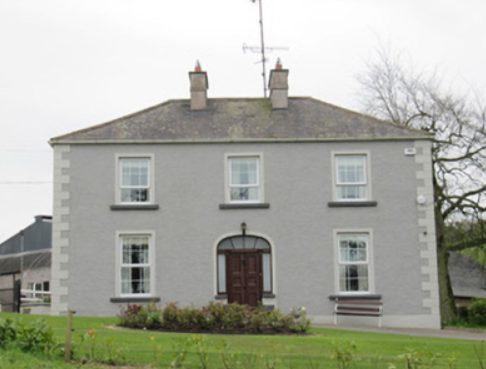
| Lake View (Ematris) | This house looks out on Long Lough. It was occupied by William Richey and valued at £10, circa 1860. Home of the Gillespie family in the early 20th century. |
|
| Bailieborough Castle/Lisgar Castle | A Scottish planter named William Bailie built a castle here in the early 17th century. It passed into the possession of a number of prominent families Hamilton, Stewart and Corry until it was sold to Colonel William Young in 1814. His son, Sir John Young, later created 1st Baron Lisgar, built a new house on the site in the 1860s. At the end of the 19th century the house was sold to Sir Henry Cochrane and in 1915 to the Marist Brothers of Athlone. Badly damaged by fire in 1918 but reconstructed, the house was eventually demolished in 1942. For image see https://www.archiseek.com/ | |
| Beckscourt House | Becks Court, located just outside the town of Bailieborough on the Young estate, was occupied by the Reverend Arnold Cosby in 1814. Lewis records the Reverend E. Mahaffy as resident. By the mid-19th century it was occupied by Sarah Mahaffy who held the property from Sir John Young of Bailieborough Castle. The buildings were valued at £12. | |
| Spear Vale/Vale House | In 1814, Ambrose Leet refers to William Spear of Spear Vale, Bailieborough. In 1837, Lewis described the home of W. Spear as comfortable with an extensive bleach green about one mile from the town. The Reverend Frederick FitzPatrick occupied the house in the mid-19th century holding it from William Spear. The buildings had a rateable valuation of £12. This house is no longer extant. | |
| Spear Vale/Vale House | In 1814, Ambrose Leet refers to William Spear of Spear Vale, Bailieborough. In 1837, Lewis described the home of W. Spear as comfortable with an extensive bleach green about one mile from the town. The Reverend Frederick FitzPatrick occupied the house in the mid-19th century holding it from William Spear. The buildings had a rateable valuation of £12. This house is no longer extant. | |
| Corraneary House | 18th century generations of the Adams family of Shercock lived at Corraneary, Knockbride, county Cavan, possibly in a building marked on the first edition six inch Ordnance Survey map (publ. 1837) slightly to the north east of the later house. Corraneary House was built circa 1850. It was the home of Colonel Fulke Southwell Greville, held by him in fee and valued at £23. The house was part of the Greville estate offered for sale in 1864, when it was described as an ‘excellent modern dwelling house with suitable and extensive out-offices, handsomely situated on the banks of Corraneary Lake. It was erected about fifteen or sixteen years since, at an expenditure exceeding £2,000’. Occupied by local magistrate and farmer, Lewis H. Grier and family, in 1901 and by John Blair Moffatt and family in 1911. | |
| Cornashesk House | This house was not built at the time of the first Ordnance Survey in the 1830s. It was erected within the demesne of Fort William and was occupied in the 1850s by David Kellett and held from the trustees of the Marquess of Headfort. It was valued at £10. Home of the Farrelly family at the beginning of the 20th century. | |
| Fort William (Cornashesk) | A house and outbuildings are marked on the first edition six inch Ordnance Survey map (publ. 1837). Leet records Charles Kellett as the occupant of Corna-sesk in 1814. The house, which had expanded, is named on the 25 inch map. Fort William was the home of Robert Kellett in the 1850s, held from the Marquess of Headfort and valued at £14. Fortwilliam, Virginia, was the home of Ralph Harman in 1876. It is still extant. | |
| Lurgan Lodge | Lurgan Lodge was the residence of a branch of the Nixon family from the late 18th century. George Nixon of Lurgan Lodge was the fourth son of the Reverend Andrew Nixon of Nixon Lodge. George’s son, Andrew Nixon, lived here in 1814. Lurgan Lodge is named on the first edition six inch Ordnance Survey map (publ. 1837). There was a corn mill nearby. The estate of Eliza Nixon of Lurgan Lodge was advertised for sale in the Encumbered Estates Court in March 1852. Her estate was held on a 21 year lease from the Bishop of Kilmore, dated 1849. James Hunter was one of the plaintiffs. In the mid-19th century the house was occupied by John Jennings and held from James Hunter. The buildings had a rateable valuation of £15. John Jennings was described as a farmer and miller when he died in 1867 (NA, Wills and Administrations 1867, 105). In the early 20th century Lurgan Lodge was the home of Thomas Charles Kellett, a farmer and magistrate. It is still extant. | |
| Moynehall House | Moynehall was originally the home of the Moores. In 1847 Moynehall, the house and 12 acres, was been offered for lease by the Court of Chancery in the matter of Catherine Bell, a minor and heiress in law of Robert Bell, a lunatic, dated 15 February 1847 (Anglo-Celt). Griffith’s Valuation records the house as vacant and the Reverend Anthony Adams as the immediate lessor. Moynehall, the property of the Reverend Anthony Adams, was advertised for sale in the Encumbered Estates Court on 28 May 1857. In 1876, Moynehall belonged to John Fay. It is still extant. | |
| Cornahilt Lodge | Located on the outskirts of Ballyjamesduff, Cornahilt Lodge was occupied by Mary Skelton in the mid-19th century. She held the property with a rateable valuation of £12.10.0. from Robert J. Cuming. Cornahilt Lodge is now the address of a services company based in Ballyjamesduff. | |
| Fort Frederick | Fort Frederick situated close to the shore of Lough Ramor was described by Bence Jones as ‘a 2 storey mid-c18 house with a central 3 sided bow and 2 bays on either side of it’. In 1814 it was the home of Captain Sankey but by 1837 had been acquired by his relative R. Scott who was married to Eleanor Sankey. Griffith’s Valuation records Richard Scott as the occupier. The buildings were valued at £35 and were held in fee. By 1876 Alexander William Jackson Sankey owned the Fort Frederick estate, comprised of 1,324 acres. He died in 1903. His brother Harry Samuel Sankey is recorded as resident at Fort Frederic in 1910. This house continues to be a residence. |

|
| Clonervy | In 1814, Clonervy was the home of Richard Blackwood. Located on the estate of Earl Annesley it was vacant at the time of Griffith’s Valuation when its rateable valuation was recorded as £30. George Graham occupied Clonervy in the 1860s and in 1880 it was the residence of the subsheriff John Maxwell James Townley. The Irish Builder records plans for general repairs to Clonervy House for Patrick Lyons in 1912. A smaller building still occupies this site. | |
| Bellamont Forest | A red brick house, designed by Sir Edward Lovett Pearce c 1728 for Thomas Coote, younger son of Richard, Baron of Collooney. Originally known as Coote Hill but its name changed in 1767 to Bellamont Forest following Charles Coote’s elevation to the title Earl of Bellamont (2nd creation). Bellamont Forest was inherited by Charles Johnston Coote in 1800. He was one of the illegitimate children of the Earl. Bellamont Forest was occupied by Richard Coote in the mid-19th century. He held it in fee and the buildings had a rateable valuation of £50.10.0. It was sold by George Coote in 1875 to Edward Smith (K.V. Mulligan), who made a fortune out of coal. Edward Patrick Dorman Smith was the eldest son of Edward Smith and his wife Isabella Cullen and succeeded to Bellamont Forest in 1880. In 1906, Captain E. P. Smith was the occupant of the mansion house with a rateable valuation of £61.5.0. The property remained in the hands of the Smith family until the 1980s when it was purchased by an Australian, John Coote, a descendant of the former owners who spent many years renovating the house. John Coote died in 2012 and the house was sold in 2015 to an American couple. | |
| New Grove House | New Grove House and mill with a rateable valuation of £70 were in the possession of Charles Murphy in the 1850s. He held the property from Richard Coote of Bellamont Forest. A building still exists at this site but the mill is now a ruin. | |
| Ann's Fort | Located on the Coote of Bellamont Forest estate and named on the first edition 6 inch Ordnance Survey map (publ. 1837) Ann’s Fort was located in a demesne with bleaching mills ‘in ruins’ nearby. Corn and flax mills are marked on the 25 inch map at these ruins. William Worthy was the occupier of Ann’s Fort and mills in the mid-19th century when the rateable valuation of the buildings was £50. He held the property from James T. Tennant. | |
| Lislin House | Lislin House, situated close to the bank of the Annalee River, is named on the first edition six inch Ordnance Survey map (publ. 1837). The building is believed to date from the late 18th century and came into the possession of the Battersby family through marriage. At the time of Griffith’s Valuation Robert Battersby was the occupier and owner. The rateable valuation of the buildings was £6. Home of the James and Agnes Simons at the beginning of the 20th century, now a ruin. | |
| Rakenny/Rathkenny House | A two storey square block of a house built in the late 1820s for Theophilus Lucas-Clements to the design of William Farrell. According to Bence Jones it was built with money given to Theophilus ‘by his cousin, Harriet, whose father, Captain John Clements, made a considerable fortune commanding a ship in the East India Company service’. A previous Clements home had been located on the other side of the Annalee River, of which the 18th century demesne and tea house survive and a walled garden dating back to 1695. Rakenny is the name of the house on the first edition six inch Ordnance Survey map (publ. 1837) but the house is commonly known as Rathkenny. It had a rateable valuation of £48.5.0. in the mid-19th century. Rathkenny House continued to be the home of the Lucas-Clements family until it was put up for sale in 2012 (Irish Times, 10 May 2012). | |
| Wood Lodge | Wood Lodge was the home of Elizabeth Anne Clements and her husband, the Reverend Edward Lucas, at the end of the 18th century. This house was situated in the Rakenny demesne to the south of the new Rathkenny house built in the 1820s by their son. It is named on the first edition six inch Ordnance Survey map (publ. 1837) when it is shown as a square block of four buildings surrounding a court yard. Valued at £10.5.0. at the time of Griffith’s Valuation, it was occupied by William Armstrong (Lewis records J. Armstrong as proprietor of Woodford, parish of Enniskeen). The building was reduced in size as shown on the 25 inch map. The Lodge is no longer extant. | |
| Annaghlee House | This house faced the nearby Annalee River. Described by Bence Jones as a ‘mid-c18th red-brick house attributed to Richard Castle’. It is named on the first edition six inch Ordnance Survey map (publ. 1837). In 1806 occupied by Mr Willis (Matthew Sleater) and in 1814 ‘Annalea, Coothill’ was the home of Michael Murphy. Lewis in the 1830s also records ‘Annilea’ as the residence of M. Murphy. John Marsden held the property valued at £12.10.0. from Robert Burrowes in the 1850s. A large B & B complex now occupies the site. | |
| Drumeltan House | Drumeltan is named on the first edition six inch Ordnance Survey map (publ. 1837) when it had a walled garden. It was situated on the estate of the Bishop of Kilmore and was held by Isabella Cooney in the 1850s when the buildings had a rateable valuation of £9.10.0. It passed from the Cooneys to the Adams family. In 1884 Drumelton House was rebuilt by William Adams (1837-1908) to the design of James Franklin Fuller. William’s mother was a Cooney. In 1906, it had a rateable valuation of £30. It remains the home of the Adams family well into the 20th century. See http://landedfamilies.blogspot.ie/2013/04/31-adams-of-drumelton-house-and.html for image and family history. | |
| Ashfield Lodge | Described by Bence Jones as a late Georgian house, now demolished. The house faced north west and looked onto the Dromore River. It was the home of a branch of the Clements family until 1952 when sold. Colonel Henry Theophilus Clements was the occupant in the mid-19th century holding the property in fee. The house was valued at £44 for rates. | |
| Retreat/Faybrook | Retreat, set in a small demesne close to Dromore River with a corn mill nearby, is named on the first edition six inch Ordnance Survey map (publ. 1837). It appears to have been a Bredin home in the early 1850s. By the time of Griffith’s Valuation it belonged to Thomas Fay and was occupied by James Boyle. The rateable valuation was £10. The house reduced in size, or possibly a new structure, was renamed Faybrook. It is marked on the 25 inch map and is still extant. | |
| Drumsheil House | Drumsheil was originally part of the Ashe estate which was sold to the Clements family. It is named on the first edition six inch Ordnance Survey map (publ. 1837) and was situated close to a lough of the same name. The house, with a rateable valuation of £8, was occupied by William Caldwell in the mid-19th century and held from the representatives of Charles Adams. The Caldwell family were still resident in 1911. The site is now a green field. | |
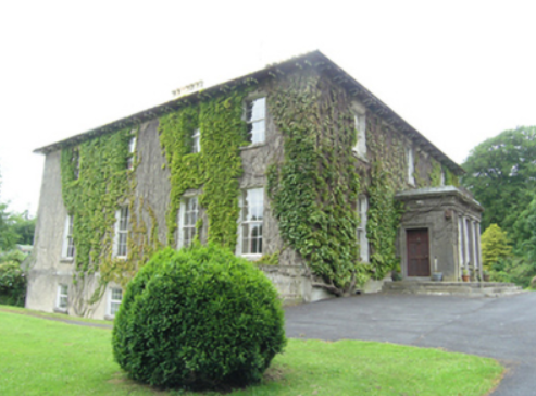
| Tullyvin House | Tullyvin was originally a home of the Moore family. In 1814 the Reverend Benjamin Adams was resident. It was inherited by Maxwell Boyle, who according to the National Inventory of Architectural Heritage rebuilt the house circa 1820. At the time of Griffith’s Valuation the house was vacant but in the possession of Maxwell W. Boyle. It was valued at £30 for rates. In 1876, Tullyvin was the home of Mrs Charlotte Townley, the owner of over 2,000 acres in the county. The house had a rateable valuation of £30.10.0. in 1906 and Maxwell J. Boyle was recorded as the occupier. This house is still a fine residence. |
|
| Fort Henry | In 1814 Fort Henry, Cootehill, was the home of the Reverend John Moore. Valued at £4 in Griffith’s Valuation it was occupied by Elizabeth J. Stinson and held from Colonel Henry T. Clements. Reduced in size on the 25 inch map, a building still stands on this site. | |
| Fort William/Errigal | Situated on the north side of the Annalee River, Fort William is named on the first edition six inch Ordnance Survey map (publ. 1837). By the time of Griffith’s Valuation it was owned and occupied by Samuel Moorhead. The rateable valuation was £25. The house was extended and renamed ‘Errigle’ as shown on the 25 inch map. In 1906, it had a rateable valuation of £40 and was occupied by Thomas H. Moorhead MD. It now functions as the Errigal Country Hotel. | |
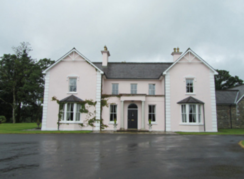
| Billis Grange | A house built after the first edition six inch Ordnance Survey map (publ. 1837) was surveyed. Mrs D. Delap was the owner and occupier in the mid-19th century when the buildings were valued at £13. There is a reference to W.C. Peyton of Billis Grange in a document in the Farnham Papers, Ms 11,499 (NLI). The building was possibly extended towards the end of the 19th century. The National Inventory of Architectural Heritage dates the present house c. 1890. The 25 inch map shows a substantial house in parkland with a lodge at the entrance gate. In 1906, Henry Sankey held over 300 untenanted acres in this locality including a building with a rateable valuation of £16.10.0. This house continues to be a family residence. |
|
| Countenan House | Countenan House on the shore of Countenan Lough is named on the first edition six inch Ordnance Survey map (publ. 1837). It was occupied by Thomas Hartley in the 1850s and held from Robert Burrowes. The rateable valuation was £10.10.0. Home of the Hawe family at the beginning of the 20th century, this house is apparently still attached to a farming enterprise. | |
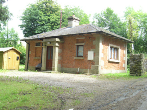
| Stradone | According to Burke’s Irish Family Records the Burrowes family were resident at Stradone from at least the mid-18th century. The architect J.B. Keane designed the 19th century house for Major Thomas Burrowes in 1828. His son Robert Burrowes was the owner and occupant in the 1850s when the rateable valuation was recorded as £67.10.0. The Burrowes were still in possession of Stradone in the early 20th century until it was burnt in June 1921. The stables and a gate lodge survive. |
|
| The Lodge | A sporting lodge built by the Taylour family before 1800 and originally known as Cottage. It was extending circa 1820 and again circa 1860. It is situated close to Lough Ramor and on the outskirts of the town of Virginia. The Lodge was valued at £37 in the 1850s when the Earl of Bective was recorded as the occupant. By 1906, the rateable valuation had risen to £105. The building now functions as a hotel, see http://www.virginiaparklodge.com/ |

|
| Quilca House | Quilca was associated with the Sheridan family. The Reverend Thomas Sheridan was a friend of Dean Swift. In 1725 the Dean wrote some of ‘Gulliver’s Travels’ while staying with the Sheridans at Quilca. In 1814 Robert Doughty was resident and the Reverend Luke O’Reilly in the 1830s. No occupant is given in Griffith’s Valuation when the building was described as a herd’s house and was valued at £5. Joseph Le Fanu was the immediate lessor. A mid-20th century house now occupies the site. | |
| Shinan House | Shinan House was the home of a branch of the Adams family from the early 19th century. Lewis records ‘Shenan’ as the residence of E. Wilson. By the mid-19th century it was valued at £50 and was owned and occupied by Captain Benjamin Adams. Charles Adams was in possession of Shinan House in the early 20th century. It was later demolished. | |
| Corravahan House | Built circa 1841 by Rev Marcus Gervais Beresford, later Archbishop of Armagh, close to the site of the former Drung Parsonage. The house served as the parish rectory until 1870 when it was sold to the Rev Charles Leslie, cousin of the Glaslough Leslies. In 1906, it was occupied by Captain C.R. Leslie and had a rateable valuation of£39. It remained a Leslie family home until 1972. Bought by the Elliott family in 2003 who have been renovating the house and gardens. |
|

