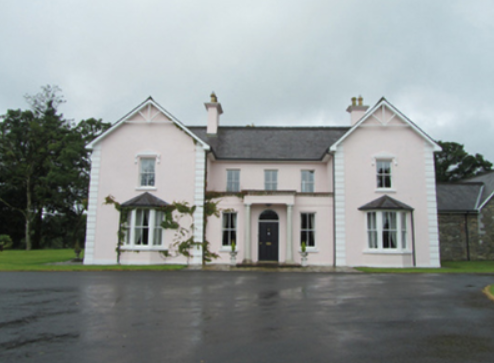
Beehive
Houses within 10km of this house
Displaying 8 houses.
Houses within 10km of Beehive
Displaying 8 houses.
| House name | Description | |
|---|---|---|
| Bailieborough Castle/Lisgar Castle | A Scottish planter named William Bailie built a castle here in the early 17th century. It passed into the possession of a number of prominent families Hamilton, Stewart and Corry until it was sold to Colonel William Young in 1814. His son, Sir John Young, later created 1st Baron Lisgar, built a new house on the site in the 1860s. At the end of the 19th century the house was sold to Sir Henry Cochrane and in 1915 to the Marist Brothers of Athlone. Badly damaged by fire in 1918 but reconstructed, the house was eventually demolished in 1942. For image see https://www.archiseek.com/ | |
| Spear Vale/Vale House | In 1814, Ambrose Leet refers to William Spear of Spear Vale, Bailieborough. In 1837, Lewis described the home of W. Spear as comfortable with an extensive bleach green about one mile from the town. The Reverend Frederick FitzPatrick occupied the house in the mid-19th century holding it from William Spear. The buildings had a rateable valuation of £12. This house is no longer extant. | |
| Corraneary House | 18th century generations of the Adams family of Shercock lived at Corraneary, Knockbride, county Cavan, possibly in a building marked on the first edition six inch Ordnance Survey map (publ. 1837) slightly to the north east of the later house. Corraneary House was built circa 1850. It was the home of Colonel Fulke Southwell Greville, held by him in fee and valued at £23. The house was part of the Greville estate offered for sale in 1864, when it was described as an ‘excellent modern dwelling house with suitable and extensive out-offices, handsomely situated on the banks of Corraneary Lake. It was erected about fifteen or sixteen years since, at an expenditure exceeding £2,000’. Occupied by local magistrate and farmer, Lewis H. Grier and family, in 1901 and by John Blair Moffatt and family in 1911. | |
| Wood Lodge | Wood Lodge was the home of Elizabeth Anne Clements and her husband, the Reverend Edward Lucas, at the end of the 18th century. This house was situated in the Rakenny demesne to the south of the new Rathkenny house built in the 1820s by their son. It is named on the first edition six inch Ordnance Survey map (publ. 1837) when it is shown as a square block of four buildings surrounding a court yard. Valued at £10.5.0. at the time of Griffith’s Valuation, it was occupied by William Armstrong (Lewis records J. Armstrong as proprietor of Woodford, parish of Enniskeen). The building was reduced in size as shown on the 25 inch map. The Lodge is no longer extant. | |
| Drumeltan House | Drumeltan is named on the first edition six inch Ordnance Survey map (publ. 1837) when it had a walled garden. It was situated on the estate of the Bishop of Kilmore and was held by Isabella Cooney in the 1850s when the buildings had a rateable valuation of £9.10.0. It passed from the Cooneys to the Adams family. In 1884 Drumelton House was rebuilt by William Adams (1837-1908) to the design of James Franklin Fuller. William’s mother was a Cooney. In 1906, it had a rateable valuation of £30. It remains the home of the Adams family well into the 20th century. See http://landedfamilies.blogspot.ie/2013/04/31-adams-of-drumelton-house-and.html for image and family history. | |
| Billis Grange | A house built after the first edition six inch Ordnance Survey map (publ. 1837) was surveyed. Mrs D. Delap was the owner and occupier in the mid-19th century when the buildings were valued at £13. There is a reference to W.C. Peyton of Billis Grange in a document in the Farnham Papers, Ms 11,499 (NLI). The building was possibly extended towards the end of the 19th century. The National Inventory of Architectural Heritage dates the present house c. 1890. The 25 inch map shows a substantial house in parkland with a lodge at the entrance gate. In 1906, Henry Sankey held over 300 untenanted acres in this locality including a building with a rateable valuation of £16.10.0. This house continues to be a family residence. |
|
| Countenan House | Countenan House on the shore of Countenan Lough is named on the first edition six inch Ordnance Survey map (publ. 1837). It was occupied by Thomas Hartley in the 1850s and held from Robert Burrowes. The rateable valuation was £10.10.0. Home of the Hawe family at the beginning of the 20th century, this house is apparently still attached to a farming enterprise. | |
| Stradone | According to Burke’s Irish Family Records the Burrowes family were resident at Stradone from at least the mid-18th century. The architect J.B. Keane designed the 19th century house for Major Thomas Burrowes in 1828. His son Robert Burrowes was the owner and occupant in the 1850s when the rateable valuation was recorded as £67.10.0. The Burrowes were still in possession of Stradone in the early 20th century until it was burnt in June 1921. The stables and a gate lodge survive. |
|