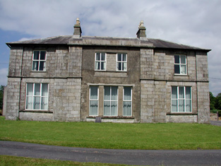
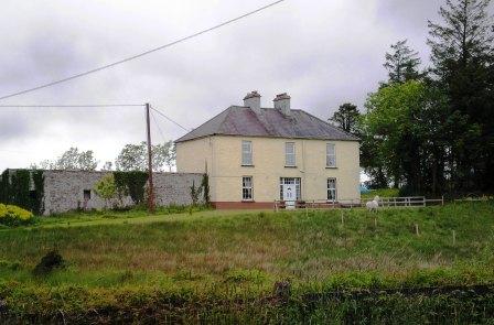
Cottage Vale
Houses within 15km of this house
Displaying 56 houses.
Houses within 15km of Cottage Vale
Displaying 56 houses.
| House name | Description | |
|---|---|---|
| Druminshin Glebe | Rev. James Agar held this property at Druminshin Glebe freehold at the time of Griffith's Valuation when it was valued at £30. The property seems to have been known as Carrigallen Glebe or Carrigallen Lodge at various times though it is recorded as Druminshin Glebe house on the first edition Ordnance Survey map. It is still extant and occupied. |
|
| Kilbracken | William Murray Hickson was leasing the house at Kilbracken, barony of Carrigallen, from Elizabeth Armstrong at the time of Griffith's Valuation when it was valued at £20. In 1814 a house at Kilbracken was recorded as the residence of Mr. Armstrong but it has been estimated that the present Kilbracken House was built around 1825. It is not named on the first edition Ordnance Survey map though there are buildings marked on the site. A poster in Leitrim County Library indicates that it was the property of Thomas S.Jones in 1905 when it was offered for sale. The house is still extant and undergoing restoration. |
|
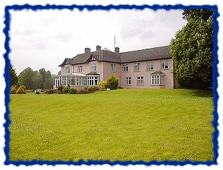
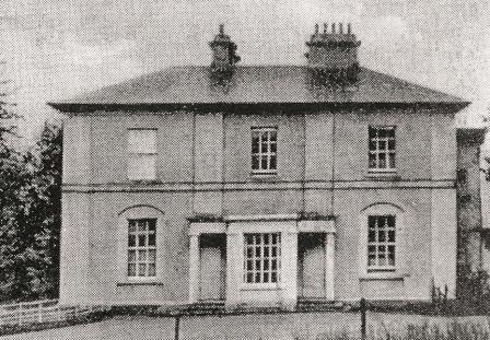
| Lough Rynn | Lough Rynn was built in the early 1830s by Robert, Viscount Clements, heir to the 2nd Earl. At the time of Griffith's Valuation it was valued at £40. In 1906 it is recorded as the property of Col. H.T. Clements and has a valuation of £100. It is still extant. In 2006 it opened as a luxury hotel. For more information see www.loughrynn.ie and www.loughrynn.net. |
|
| Killygar | It is estimated by the National Inventory of Architectural Heritage that Killygar was built in 1813. At the time of Griffith's Valuation Killygar House was occupied by John Godley and was valued at £43. It was also the residence of John Godley in 1814 and in 1837. In 1894 Slater refers to it as the seat of Archibald Godley. It is still extant and occupied by the Godley family. |
|
| Woodford | Woodford was the residence of Robert J. Gore at the time of Griffith's Valuation when it was valued at £15. In 1814 it was occupied by John Gore. Both Taylor and Skinner and Wilson also record it as a seat of the Gore family in the 1780s. The house at Woodford Demesne, described as "formerly the residence of the Rev. Gore" was "formerly a genteel residence but now in a ruinous state" at the time of the first Ordnance Survey in 1835. Lewis records it as the seat of Ormsby Gore in 1837. In 1906 it was the property of Emily Upperton and was valued at £19. The National Inventory of Architectural Heritage states that it retains little original fabric but much of the estate architecture, including the site of the walled garden survives. There is also an earlier castle at this site. |
|
| Cloghlough | At the time of Griffith's Valuation, William O'Brien was leasing a property valued at £8 at Cloghlough, barony of Carrigallen, from the estate of John King, which was in Chancery. Substantial farm buildings exist at this site. | |
| Jamestown House or Jamestown Lodge | At the time of Griffith's Valuation Hugh O'Beirne was occupying a house at Jamestown, barony of Leitrm, valued at £40. Jamestown House was held by the O'Beirne family until the twentieth century though in 1894 Slater refers to it as the seat of Gilbert King, junior. In 1906 it was also valued at £40. It is still extant and occupied. |
|
| Drumsillagh | Acheson O'Brien was leasing the property at Drumsillagh, barony of Carrigallen, from the King estate (in chancery) at the time of Griffith's Valuation when it was valued at £15. Lewis also records it as a seat of the O'Brien family in 1837. In 1906 Drumsillagh was owned by the representatives of William A. O'Brien and was also valued at £15. There appears to be still a house at this site. | |
| Corduff House | The National Inventory of Architectural Heritage estimates that Corduff House was built c.1780. William Penrose was occupying the house at Corduff, barony of Carrigallen, at the time of Griffith's Valuation when it was valued at £8. Corduff House is recorded as the seat of the Penrose family by Lewis in 1837. In 1814 it was the residence of George Percy. The house is still extant and occupied. |
|
| Willowfield | Alexander Percy was occupying the house at Aghatawny, known as Willowfield, at the time of Griffith's Valuation when it was valued at £10.Lewis records it as a seat of the Percy family in 1837. In 1814 it was the residence of William Shanley. Both Taylor and Skinner and Wilson also record it as a seat of the Shanley family in the 1780s. The building is still extant. | |
| Garadice | John Percy was leasing the house at Garadice, barony of Carrigallen, from the representatives of William Percy at the time of Griffith's Valuation when it was valued at £15. In 1814 it was noted as a residence of the Percy family. Lewis records it as the seat of W.C. Percy in 1837. In the 1780s both Taylor and Skinner and Wilson noted Garadice as a Percy residence. The ITA survey recorded it as much deteriorated in the 1940s. It also mentions the existence of a second house belonging to the Percy family in the townland of Carrickmakeegan. The buildings are still extant at Garadice. | |
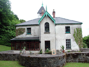
| Riversdale | Matilda Shanley was leasing Riversdale House at Corrachole to William Lawder in the 1850s when it was valued at £12. In 1837 Lewis records it as the seat of the Shanley family. It is still extant and operates as a farm guesthouse. |
|
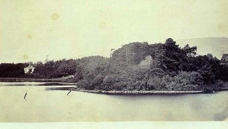
| Clooncorick Castle | Formerly an O'Rourke castle, Clooncorrick was held by several other families, notably the Irwins, before being bought by Pierce Simpson in 1835. In 1814 it is recorded as the residence of Rev. Agar. At the time of Griffith's Valuation it was being leased by Pierce Simpson from the Ormsby Gore estate and was valued at £40. Lewis also records it as the seat of the Simpson family in 1837. In the 1930s the castle was dismantled and the fittings sold. The ITA survey in the 1940s recorded that the castle had recently been demolished. | |
| Mohill Castle | At the time of Griffith's Valuation John Kane was leasing a property valued at £20 from Sir M. Crofton in the town of Mohill. |
|
| Lawderdale | The National Inventory of Architectural Heritage survey states that Lawderdale was built in the early 1850s and has a tower which was added in the 1870s. At the time of Griffith's Valuation it was the property of William Lawder and was valued at £18. In 1906 it was the property of James Ormsby Lawder and was valued at £30. It is still extant. |
|
| Mough | Mough was one of the original properties held by the Lawder family from their arrival in the Leitrim area. Burke suggests that Mough afterwards became Lawderdale but map evidence would suggest that they were separate though adjacent properties. At the time of Griffith's Valuation the house was valued at £18. | |
| Mount Campbell | Josias Rowley was leasing the property at Mount Campbell, valued at £35, to William A. Lawder at the time of Griffith's Valuation. Slater refers to it as the seat of William S. Lawder in 1894. In 1906 William Rowley owned the mansion at Mount Campbell valued at £40. The house is no longer extant. |
|
| Lismoyle | At the time of Griffith's Valuation Francis Waldron was the owner of a property valued at £12 at Lismoyle, barony of Leitrim. A house still exists at this site. | |
| Laheen | In the 1780s both Taylor and Skinner and Wilson recorded Laheen as a seat of the Peyton family. Lewis also records it as a Peyton residence. At the time of Griffith's Valuation it was being leased by Richard Peyton to Michael Fitzgerald and was valued at £15. The original Laheen house is not extant though a house and extensive farm buildings remain at the site. | |
| Derrycarne | At the time of Griffith's Valuation Derrycarne was the property of William Ormsby Gore and was valued at £30. Lewis records it as the seat of the Nisbett family in 1837. In 1906 it was in the possession of Lord Harlech (Ormsby Gore) and was valued at £33. The Ormsby Gore estate was eventually sold in 1924 and Derrycarne and about 80 acres were acquired by a Col. Kirkwood, a relative of the Kirkwood family of Woodbrook, county Roscommon. It changed hands again several times before being acquired by the Land Commission in 1952. The house was demolished shortly afterwards. | |
| Keonbrook | In 1783 Taylor and Skinner record Kanebrook but not the name of the family whose residence it was. Keonbrook, the residence of the Keon family, was occupied by John F. Tottenham in 1856. In 1906 it is recorded as the property of Bridget Mollahan and was valued at £14. A modern house has been constructed in the demesne. | |
| Loughscur | Loughscur was originally a seat of the Reynolds family but later passed into the ownership of the Peyton family through marriage. In 1894 Slater refers to it as the seat of James Reynolds Peyton. However, this may refer instead to the Peyton property at Laheen. | |
| Annadale | At the time of Griffith's Valuation, William Slack was leasing the house at Kiltubbrid from the Ecclesiastical Commissioners when it was valued at £11. Lewis also records it as the residence of the Slack family. According to the National Inventory of Architectural Heritage survey, Annadale House was built c.1760. It is still extant and occupied. |
|
| Driney | In 1906 the mansion house at Driney was valued at £31. At the time of Griffith's Valuation it was occupied by Rev. Walter C. Peyton and was valued at £10. In 1814 it was the residence of Walter Peyton and was also recorded as the seat of the Peyton family in 1837. It was also recorded as a seat of the Peyton family by Taylor and Skinner in 1783. There is no evidence of a house at this site now. |
|
| Glasdrumman | The property at Glasdrumman in the parish of Fenagh, belonging to William Lewis, described as "in chancery" was leased to John Murphy in 1856 when it was valued at £8. It is still extant and occupied. |
|
| Fenagh Glebe | Rev. George Beresford held the Glebe at Fenagh, from the Ecclesiastical Commissioners at the time of Griffith's Valuation when it was valued at £16. The Buildings of Ireland survey states that the house was built c. 1829. It also records that the nearby church, built c.1790, was extended in the 1850s by the Pack Beresford family. Both buildings are still extant and in use. |
|
| Letterfine/Letterfyne | Letterfine was occupied by the representatives of Mary Anne McNamara in the mid 1850s. In 1814 it was the address of Tobias Peyton. Taylor and Skinner and Wilson both record it as a seat of the Reynolds family in the 1780s. It is labelled Letterfine House on the 1st edition Ordnance Survey Map but is not visible on the later 25-inch edition. In 1943 the Irish Tourist Association survey recorded no trace of the house. | |
| Bunnybeg House | Lewis records Bonnybeg as a seat of the Lawder family in 1837. At the time of Griffith's Valuation it was owned by William Lawder and was valued at £10. A modern house and farm exist at the site now. | |
| Lakeview (Mohill) | At the time of Griffith's Valuation William Slacke was leasing a property valued at £8 at Drumdart, barony of Leitrim, to William Lawder. | |
| Drumrahan | Lewis records Drumrahan as a seat of the O'Brien family in 1837. At the time of Griffith's Valuation it was being leased by John O'Brien to Phillip Taggart and was valued at £25. Entrance gates have been reconstructed but the original house is not extant. | |
| Lakefield | Lakefield House was associated with the Crofton family since the mid eighteenth century . A new house was constructed between 1771-1798. At the time of Griffith's Valuation it was leased by Duke Crofton from Hugh Carmichael,M.D. and was valued at £25. The house continued in Crofton ownership until 1931 when the estate was purchased by the Land Commission. It is now a ruin. | |
| Aughry House | Aughry House built after the publication of the First Edition Ordnance Survey map. At the time of Griffith's Valuation it was owned and occupied by Charles T. Ward and was valued at £13. Aughry Castle (in ruins) is visible nearby on the 1st edition map. This may be the property referred to in 1786 by Wilson as the seat of Mr. Nesbit. Elaborate modern entrance gates identify Aughry House which appears to be close to the site of the original. | |
| Drumcree Mill | Josias Rowley was leasing a mill and house valued at £13 in this townland to Alexander Acheson in the 1850s. | |
| Drumard House | Rev. Thomas Jones was leasing a property at Drumard, barony of Mohill, valued at £25 to William Jones at the time of Griffith's Valuation. It is no longer extant. | |
| Gort House | Margaret O'Brien was leasing a house valued at £15 in the townland of Gortnalamph from the Clements estate in the 1850s. Gort House is still extant and occupied. |
|
| Cloone Grange | A house built after the publication of the first Ordnance Survey Map. At the time of Griffith's Valuation Rev. John Carson was occupying the property which was valued at £25. In 1906 William H. White was the owner of this house, valued at £28. The site of the original house is now occupied by farm buildings. | |
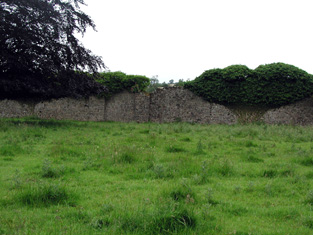
| Headfort/Headford | At the time of the first Ordnance Survey the property at Headford was described as belonging to "S. White, non resident, property going into decay". In the seventeenth and eighteenth centuries it was a seat of the Jones family. Wilson, perhaps incorrectly, refers to it as the seat of Mr. Johnston, in 1786. The house was immortalised by Anthony Trollope in his novel ''The McDermotts of Ballycloran''. The ITA survey of the 1940s recorded it as in ruins and it remains as an ivy-covered ruin today. It was pointed out for this survey as "the ruins of that auld Ballycloran Castle"! |
|
| Clooncoe House | Lewis records "Brooklawn" as a seat of the O'Brien family in 1837. Brooklawn House in the townland of Clooncoo, parish of Cloone, was part of the Clements estate but is described at the time of the first Ordnance Survey as the seat of a Mr. Crawford. It is labelled Brooklawn on the 1st edition Ordnance Survey map but as Clooncoe House on all subsequent editions. It is still extant and occupied. |
|
| Lurga House | At the time of Griffith's Valuation, Francis Scanlan was leasing a property at Lurga, barony of Mohill, valued at almost £3 together with over 90 acres from the Crofton estate. This property is labelled Lurga House on the 1st edition and subsequent maps. A house and farm are still extant at the site. | |
| Cartron (King) | The home of the Waldron family in the 18th and early 19th centuries. Occupied by Gilbert Hogg in 1837. Valued at £10 and occupied by John B. Hogg at the time of Griffith's Valuation who held the house from Sir Gilbert King. A substantial farm is still extant at the site. | |
| Cloonteem | Described in 1837 by Lewis as "a handsome and newly erected lodge of the Marquess of Westmeath". The house was valued at £14 in the 1850s and was held by Lord Greville in fee. The buildings have disappeared by the time the 25-inch Ordnance Survey map was published in the 1890s. | |
| Charlestown House | In 1786 Wilson refers to Charlestown as the "the fine seat of Mr. King, most delightfully situated on the Shannon". The first Ordnance Survey map marks both Charlestown House and Charlestown Old House closeby at M984 976. Valued at £46 at the time of Griffith's Valuation. In 1894 Charlestown was the residence of Sir Gilbert King. The house is no longer extant but extensive estate architecture survives. |

|
| Flanker House | The Walsh estate, including Drumsna House, was advertised for sale in the Landed Estates' Court in 1861. The sale notice describes the dwelling house as "handsome and commodious" with a large walled garden. At the time of Griffith's Valuation Mary Anne Walsh was leasing the house, valued at £22 from Josias Rowley. The accompanying map indicates that it was called Flanker House. In the 1870s several members of the Keogh family, with an address at Flanker House, Drumsna, held property in county Roscommon. |

|
| Drumdartan Glebe | At the time of Griffith's Valuation, Daniel Etough was occupying the house at Drumdartan Glebe valued at £16. In 1837 Lewis had recorded it as a residence of the Percy family. The property is now derelict. | |
| Boeeshil House | At the time of Griffith's Valuation William Shanley was leasing a property at Boeeshil, barony of Carrigallen, incuding a house and corn mill, valued at £20, from the Percy estate. There are three mills shown at the site on the 1st edition 6" OS map, including a corn, bleach and flax mill. Lewis records this property as belonging to the Gerard family. | |
| Clooncahir | John Walsh was the lessor of a vacant house valued at £12 at Clooncahir, barony of Mohill at the time of Griffith's Valuation. He was leasing lands in the same area from the Crofton estate. A house still exists at the site. | |
| Drumod More | At the time of Griffith's Valuation, Catherine Warren was leasing a house valued at £9 to Francis Murphy at Drumod More, barony of Mohill. Extensive redevelopment and road building have taken place in this area though there are still buildings at the site. | |
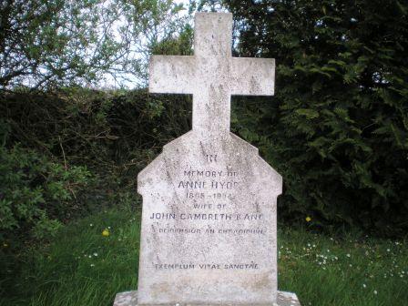
| Drumkilla or Mohill Glebe | At the time of Griffith's Valuation Rev. Arthur Hyde was leasing the Glebe at Drumkilla, valued at £22, from the Ecclesiastical Commissioners. | |
| Drumliffen Glebe | At the time of Griffith's Valuation Rev. Wm. Percy was leasing a property valued at £12 at Drumliffen Glebe, barony of Leitrim, from the Ecclesiastical Commissioners. The property is still extant and part of a farm. | |
| Glebe Mohill | At the time of Griffith's Valuation, Rev. Arthur Hyde was leasing the glebe house at Drumkilla, barony of Mohill from the Ecclesiastical Commissioners. It was then valued at £22. | |
| Lowfield | A Lawder home in the 18th and early 19th centuries. Occupied by John B. Hogg at the time of Griffith's Valuation who held it from Sir John Gilbert. The house was valued at £2. It is not visible on the 25-inch map of the 1890s. | |
| Belmont | At the time of Griffith's Valuation Mary Anne Walsh was leasing a property valued at £17 to Hugh Byrne at Drumsna, barony of Leitrim. In June 1883 Gerald F. Walsh offered for sale the property in Drumsna known as Belmont. Modern housing now occupies the site. | |
| Laurel Bank/Holly Bank | This house, originally known as Laurel Bank, is named on the first edition six inch Ordnance Survey map (publ. 1837). It is shown in a demesne which included an old bleach mill and a corn mill and kiln. It is believed to have been built by a mill owner in the 18th century. Griffith’s Valuation records William Norton as the occupant holding the property valued at £8.10.0. from the Earl of Gosford. The house is called Holly Bank on the 25 inch map. Altered and added to in the 20th century it continues to be a residence. | |
| Moneylagan Cottage | In 1837 Lewis referred to Moneylagan as the seat of Dr. Forbes Crawford. At the time of Griffiths Valuation in the early 1850s it was leased by General James Hey from John Crawford when it was valued at almost £14. The 1840 Valuation Office books show a £15 valuation. An altered house is extant at the site now. | |
| Knockmartin House | Michael Cody was leasing this property from the Porter estate at the time of Griffiths Valuation in the early 1850s when it was valued at over £12. It is labelled Knockmartin House on the 25-inch OS map of the early 20th century. A later house exists at the site. | |
| Crowdrumin Lodge | At the time of Griffiths Valuation in the early 1850s Patrick Mannion was leasing this property from Samuel Galbraith’s estate when it was valued at just over £3. A more substantial property, labelled Crowdrumin Lodge, is shown on the 25-inch Ordnance Survey map of the early 20th century. It has been replaced by a modern house. |