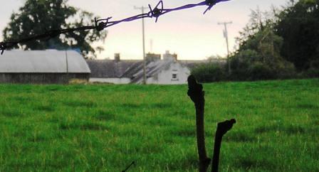
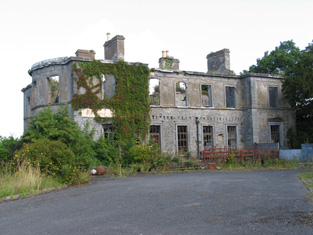
Harvest Lodge
Houses within 5km of this house
Displaying 14 houses.
Houses within 5km of Harvest Lodge
Displaying 14 houses.
| House name | Description | |
|---|---|---|
| Earlstown | In 1786 Wilson refers to "Capasell" s the seat of Mr. Devenish [?]. The house at this location is labelled Earlstown on the 1st edition Ordnance Survey map. In 1846 Slater refers to Robert Grace resident at Earlston. Robert Eyre was leasing a property in the townland of Cappasallagh, parish of Kilmalinogue, barony of Longford, valued at £11 from the Clanricarde estate in 1856. There are still occupied buildings at this site, the focus of a large farming enterprise. |
|
| Gortaha House | Cuthbert Featherston held a property valued at £10 in the townland of Gortaha, parish of Lickmolassy, barony of Longford, in 1856. It is labelled Gortaha House on the 1st edition Ordnance Survey Map. The 25-inch map of the 1890s records that it was "in ruins" and very little now remains. | |
| Redwood House | Redwood was the home of the Bloomfield family in county Tipperary, occupied by Major Bloomfield in 1837. In 1840 the Ordnance Survey Name Books mention that Redwood was "a commodious house, at present occupied by a party of the constabulary and also the residence of Mr. Ryan, under-agent to Maj. Bloomfield". It is marked as a police station on the 1st edition Ordnance Survey map. At the time of Griffith's Valuation. Phillip Crawley held the property from Lord Bloomfield and the house was valued at £15. Redwood House later became a Trench home, valued at £18.15 shillings in 1906. It no longer exists. | |
| Abbeville | Home of the Hemsworth family in the 18th and 19th centuries, occupied by Thomas Hemsworth in 1814. Thomas G. Hemsworth was resident in 1837 and in the early 1850s. Thomas George Hemsworth of Abbeville owned 387 acres in the 1870s. |
|
| Firmount | The seat of the Firman family in the late 18th century, occupied by Thomas P. Terman in 1814. The house is marked on the first edition Ordnance Survey map. The Ordnance Survey Name Books refer to it as "the mansion house of Firmount now falling into ruins, It appears to be a ruin by the time of Griffith's Valuation. The only buildings over £10 valuation were the Santa Cruise flour mill and house of Samuel Palmer. The Irish Tourist Association surveyor records "an extremely charming house converted from stabling" at Firmount and occupied by Major H.H. Deasy in the early 1940s. The surveyor states that the original house was destroyed by fire. | |
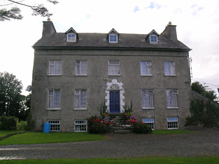
| Kilcarren | A house occupied by Ralph Smith in 1814 and by A. Carew in 1837. The Ordnance Survey Name Books describe it as "a good dwelling house" in 1841. Alexander Carew, a descendant of Lynn Carew, held the property from Ralph Smith in the mid 19th century when the buildings were valued at £17+. The house is still extant and occupied. |

|
| Lackeen | Lackeen House is an early 18th structure attached to part of a 17th century house. John Baily was the proprietor of Lackeen Castle, Parsonstown [Birr], in 1814 and in the mid 19th century the house valued at £12.10 shillings was occupied by Hamilton English and held from Lord Cremore. This house is now unoccupied. |
|
| Ballyquirk | In 1837 Lewis refers to the ruins of Ballyquirk castle "near which is a handsome modern house of that name". Colonel Henry Dwyer was the occupant in the mid 19th century, holding the house valued at £32 and 716 acres from Edward Newingham. |
|
| Curraghglass | J.W. Walsh is noted as the proprietor of Curraghglass in the Ordnance Survey Name Books of 1841. In the mid 19th century Thomas Meara occupied a house valued at £11 and held from the representatives of Jonathan Walsh. There is still a building located at this site. | |
| Firville | In 1841 the Ordnance Survey Name Books refer to "Ferville" as the residence of R.F. Drought. William S. Smith occupied the house in the mid 19th century which he held from Ralph Smith. It was valued at £15+. This building is still part of a farm complex. | |
| Belle Isle | A house overlooking the River Shannon, originally the home of a junior branch of the family it became the property of the 3rd Lord Avonmore through his second marriage to Cecilia O'Keeffe. The seat of 3rd Lord Avonmore in the mid 19th century held by him in fee and valued at £48. Belle Isle was occupied by Thomas Maunsell in 1814 and by Lord Avonmore in 1837. This house is no longer occupied. |

|
| Portland Park | A residence of the Stoney family from at least the 1770s, when it was purchased from the Earls of Antrim. Occupied by Richard Stoney in 1814 and by J. Chapman in 1837. In 1841 the Ordnance Survey Name Books described it as "a spacious building, the residence of Thomas B. Stoney with a great demesne". At the time of Griffith's Valuation he held the property in fee when the buildings were valued at £40. Portland Park remained in the possession of the Stoney family until it was burnt in 1936 (Irish Times, 11 May 1936). It is now a ruin. |
|
| Redwood | Marked on the first edition Ordnance Survey map as Moatfield House and on later maps as Redwood. Moate-field, Burris-a-kane, was the home of William Clarke in 1814. In 1841 the Ordnance Survey Name Books refer to it as "Moat Field, a good dwelling house the residence of Miss Clarke". In the mid 19th century Robert Daly held a house valued at £15 and 324 acres in Redwood from Lord Bloomfield. Redwood is still extant. | |
| Roden House | In 1841 the Ordnance Survey Name Books describe Roden House as "a good dwelling house". C.W. Hemsworth is noted as the proprietor. At the time of Griffith's Valuation, it was occupied by Thomas R. Deane, leasing from Thomas Hackett, when the buildings had a valuation of almost £3. The National Inventory of Architectural Heritage dates this property to 1784. It is still extant and occupied. |
|