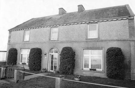
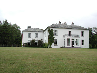
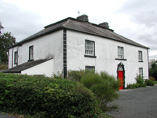
Drominagh Lodge
Houses within 5km of this house
Displaying 15 houses.
Houses within 5km of Drominagh Lodge
Displaying 15 houses.
| House name | Description | |
|---|---|---|
| Burke's Court | In 1846, Slater refers to Mrs. Bedelia Burke, resident at Clondagoff. At the time of Griffith's Valuation, Garrett Burke was leasing a house valued at £7 at Cloondadauv, parish of Ballinakill, barony of Leitrim, from the Clanricarde estate. The house is labelled Burke's Court on both the 1st and 25-inch edition Ordnance Survey maps. A house still exists at the site. An ancient Burke castle is also sited in this townland. |
|
| Castle Biggs/Drominagh | The Smythe sale rental of July 1870 states that the original lease (1711) was from Godfrey Boate and Benjamin Friend to William Biggs. Built by the Biggs family on the shore of Lough Derg this house was occupied by William L. Biggs in 1814 and by Dr W. Biggs in 1837. In 1840 the Ordnance Survey Name Books refer to Castle Biggs as "a most commodious house". Edward Biggs was resident in the mid 19th century, holding the property from Sir John Power. The house was valued at £22. The sale rental of November 1853 describes this "3-storey mansion containing every necessity and a range of out offices". It was in the possession of Edward Biggs, the owner, and was bought by Captain William Tuthill. William Tuthill sold the property to Frederick Smythe in 1859. It was for sale again in July 1870. At this time the Esmondes of county Wexford bought it from Frederick Smythe. In the early 1940s owned by Owen Esmonde but purchased by the Moss family in the 1940s. It is still extant. |
|
| Gortmore | The sale rental states that Robert Biggs built this house for about £800 in the mid 19th century. It is not marked on the first edition Ordnance Survey map. Griffith's Valuation records Samuel Biggs as the occupier of the house, valued at £11 and held from Edward Biggs. The sale rental of November 1867 advertised the sale of a valuable leasehold, the estate of Samuel and Robert Biggs, at Gortmore (222 acres and dwelling house). The 22[2?] acre estate of Samuel Biggs at Gortmore was sold to John Samuel Clarke, the petitioner, in November 1867 for £650 (The Irish law times and solicitors' journal: Volume 1, 1868 - Page 679). A house is still located at this site. | |
| Kyle Park | Marked on the first edition Ordnance Survey map Kyle Park was occupied by Thomas G. Stoney at the time of Griffith's Valuation and held by him in fee. It was valued at £39. The Ordnance Survey Name Books had described it as " a new and commodious house built and occupied by T.G. Stoney". The Stoneys still lived at Kyle Park in the 1870s. This house is still extant. |
|
| Arranhill | Arranhill was a Stoney home in the late 18th century. Thomas Stoney was resident in 1814 and Thomas George Stoney in 1837. In 1840 the Ordnance Survey Name Books report that "it suffered considerable damage during the storm of 6 and 7 January, 1839. It is occupied at present by Mr. Skelly, land steward to George Walpole, Brusna Mills, Roscrea". The Name Books also note the Marquis of Ormond as the proprietor. Thomas G. Stoney was the occupier in the early 1850s holding the property from the representatives of T.P. Firman. The buildings were valued at £23.10 shillings. This house is described as "in ruins" on the 25-inch Ordnance Survey map of the 1890s and some of these ruins remain. | |
| Brookfield | D. Cambie is recorded as the proprietor of Brookfield, Nenagh in 1814. The Ordnance Survey Name Books refer to Brookfield as the residence of E. Talbot but "Couns. Geddy [Grady] was the proprietor. In the mid 19th century John Parker was resident, holding the property from Henry D. Grady. The Parkers and Gradys were related. The house was valued at £17 and is still in use as a residence. John Parker was still resident in the 1870s. John's only daughter, Annie, married William James Reeves in 1892 and their eldest son was Henry Parker Reeves. This family is documented in the archive at Damer House, Roscrea. |
|
| Kilgarvan | Occupied by Mr Michael Connor in 1814 and by E. Cambie in 1837. Held by Solomon R. Cambie in fee at the time of Griffith's Valuation when the buildings were valued at £14.15 shillings. The Cambies sold Kilgarvan to the Reeves in the 1870s. This house is still extant and was for sale in 1999 and again in 2002. | |
| Waterloo Lodge | Located on the shore of Lough Derg the Reverend R.P. Vaughan was resident at Waterloo in 1837. The Ordnance Survey Name Books refer to it as his residence, "a neat cottage". Edward Biggs is recorded as the occupier in the mid 19th century, holding the property valued at £10 from Dr Malony. A building is still located at this site. | |
| Mota | This house dates from about 1800. Edward Cambie was resident at Mota in 1814 and T. Pepper Roberts in 1837 and afterwards. The Ornance Survvey Name Books mention that it was his residence in 1840 and that Thomas Sadlier was the proprietor. Mota and 478 acres, the estate of Theobald Pepper Roberts, was advertised for sale in May 1850. George Taylor occupied the house valued at £15.10 shillings in the mid 19th century. He held it from Peter Byrne. Marcus Tuthill lived here later. This house is still occupied. |

|
| Gurthalougha | A mid 19th century house [built by William D. Farrar], it is not marked on the first edition Ordnance Survey map or entered in Griffith's Valuation. In the 1870s William Dent Farrar was resident. William D. Ferrar was still the occupier in 1906 when the house was valued at £35. The Irish Tourist Association surveyor records Mr Kent as resident in the early 1940s. Owned by John Paul Getty III in the first decade of the 21st century and for sale in 2010 and again in 2012. |
|
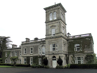
| Slevoir | Lewis records R. Monsell as resident at Slevoir in 1837. The Reverend Francis Synge was the occupier at the time of Griffith's Valuation, holding the property from the representatives of Mr Steele. The buildings were valued at £34. The National Inventory of Architectural Heritage states that the present house was built in the Italianate style in the 1870s for Lieutenant Colonel J.F. Hickey by John McCurdy. In the early 1940s General Carlos J. Hickie was the owner and the house contained very beautiful furnishings and valuable family pictures according to the Irish Tourist Association surveyor. This house sold for over £3 million in 2000 and was offered for sale again in 2011. |
|
| Newlawn | Originally a Carroll home that passed through marriage to the Dempsters. The Ordnance Survey Name Books mention J.Dempster as the proprietor of Newlawn in 1839 though elsewhere they refer to it as the residence of Mr. Egan, distiller. In the mid 19th century David Dempster was the occupant holding the property from Dr Dempster, the buildings were valued at £13.15 shillings. The building is still in use as a house. |
|
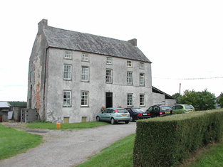
| Ballinderry | In 1840 the Ordnance Survey Name Books refer to Ballinderry House as "a good house in a demesne with some trees". James Demspter was noted as the proprietor at the time. By the time of Griffith's Valuation it appears to be the mill manager's house, occupied by William Egan and held from Timothy Hogan, part of a building complex valued at £97, known as Santa Cruise Mills. Now in use as a private residence. |
|
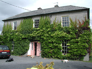
| Ashgrove | Lewis records B. Talbot as resident. In 1840 the Ordnance Survey Name Books record that the house derived its name from "a large ash grove, recently cut away". A house valued at £15+ at the time of Griffith's Valuation when it was occupied by Reverend Benjamin Talbot and held from Sir John Power. Reverend Benjamin was still resident in the 1870s. Ash Grove is still extant. |
|
| Shannon View | Close to the shore of Lough Derg, this house is marked on the first edition Ordnance Survey map. In 1840 the Ordnance Survey Name Books refer to it as "a good dwelling house". At the time of Griffith's Valuation it was occupied by Anne Talbot, held from the Reverend Benjamin Talbot and valued at £4.10 shillings. Frances Talbot of Shannonview owned 42 acres in the 1870s. It is still extant. |
|