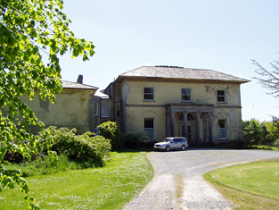
Cloneen House
Houses within 5km of this house
Displaying 10 houses.
Houses within 5km of Cloneen House
Displaying 10 houses.
| House name | Description | |
|---|---|---|
| Kilburry | The home of Jeremiah Meagher in 1814 and of Robert Maher in the mid 19th century. He held the house valued at £16.15 shillings from William Beasley. Buildings are still located at this site. | |
| Ballywalter | Occupied in the early 1850s by John Doherty, valued at £12 and held from the [Reverend] John Burdett, uncle of Arthur Burdett. | |
| Gurteen | Thomas Bryan was the proprietor of Gorteen, Callan, in 1814 and Lewis records Gurteen as the home of the Reverend W. O'Brien [Bryan?]. The Reverend William Bryan held the property in fee at the time of Griffith's Valuation when the buildings were valued at £10.15 shillings. Members of the Bryan family were still resident at Gurteen in the 1980s. Buildings still exist at this location. | |
| Bannixtown | A Clutterbuck home from at least the 1770s, Richard Clutterbuck was resident at Bannixtown in 1814. On the first Ordnance Survey map circa 1838 Bannixtown house is recorded as "in ruins". In 1840, though, the Ordnance Survey Name Books mention Bannixtown as a large farmhouse. The 25-inch map shows a building labelled "Bannixtown House" at the same site. A house valued at £19 was occupied by John Shea at Bannixtown in the early 1850s and held from the representatives of Thomas Clutterbuck. John Shea of Bannixtown owned 254 acres in the 1870s. | |
| Grove | A mid 18th century house which was altered in the 1830s. Grove was the seat of the Barton family, mentioned by Wilson as the seat of William Barton in 1786. It was occupied in 1814 by Thomas Barton and by William Barton in 1837. The Ordnance Survey Name Books describe it as "a very large dwelling house with extensive offices" in 1840. At the time of Griffith's Valuation, William Barton held Grove in fee and it was valued at £69. Grove remained in the possession of the Barton family until the mid 20th century when it passed to the Ponsonby family. This house is still extant and occupied. |
|
| Langley Lodge | In 1840 the Ordnance Survey Name Books refer to Langley Lodge as "a good house with offices and garden". This house was occupied by Mrs Mary Langley in the early 1850s. She held it from Henry Langley and the buildings were valued at £19.19 shillings. By the time of the sale in December 1853 John Kane was resident. A building is still extant at this site. | |
| Knockkelly | In the mid 19th century Richard Crane held a house valued at £12+ from William Barton in the townland of Knockkelly. This appears to be the house marked as Knockkelly house on the first edition Ordnance Survey map. | |
| Cloran | A house valued at £10. 11 shillings at the time of Griffith's Valuation, occupied by Miss Mary Kelly and held from the Earl of Clare with 224 acres. A building is still located at this site. | |
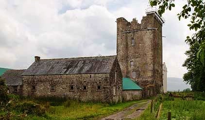
| Ballinard Castle | In 1894 Slater refers to Ballinard Castle as the residence of William Tennant. At the time of Griffith's Valuation, John Lindsay owned land in the townland of Friarsgrange, parish of Coolmundry, in which Ballinard Castle is situated. It appears that, in the nineteenth century, a house was built adjoining the original tower house as, in 1840, the Ordnance Survey Name Books refer to Ballinard Castle, a gentleman's seat in the townland of Friarsgrange. Information in the Woodstock Museum, Ontario, Canada, indicates that the building was owned by the Lindsay family until 1926. The building is still extant. |
|
| Brookhill House | In 1786 Wilson refers to Brookhill as the seat of Mr. Lowe. The 1st edition Ordnance Survey map shows Brookhill house, "in ruins", in Farranshea townland, parish of Peppardstown. An old manor house, also in ruins, is shown as well. The Ordnance Survey Name Books, in 1840, describe the site as "two large houses, one having its eastern end and the other, its eastern side, joining the ruins of the Old Manor House". At the time of Griffiths' Valuation, the townland was in the possession of the Hackett estate and the houses are described as "in ruins". The ruins are not shown on the later 25-inch map of the 1890s. |