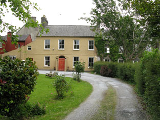
Mount Prospect (Bandon)
Houses within 5km of this house
Displaying 36 houses.
Houses within 5km of Mount Prospect (Bandon)
Displaying 36 houses.
| House name | Description | |
|---|---|---|
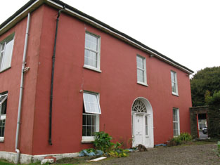
| Still View House (Cottage) | Robert Allman was leasing this property from the Earl of Shannon's estate at the time of Griffith's Valuation, when it was valued at £17 and had a mill adjacent. It is labelled Still View Cottage on the 1st edition Ordnance Survey map but an enlarged property at the site has become known as Still View House by the 1890s. A house still exists at the site. Allman was also leasing a mill, described as a flour mill on the 1st edition map. This site had expanded into an extensive woollen mill by the 1890s. Extensive industrial buildings still remain at the site. | |
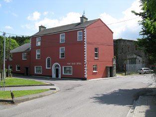
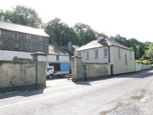
| Distillery House | Richard Allman was leasing this property and the adjacent distillery from the Earl of Shannon's estate at the time of Griffith's Valuation. The properties were valued at £200. Distillery House is labelled on the 25-inch map of the 1890s. The distillery is labelled Allman's Distillery on the 1st edition Ordnance Survey map but as Bandon Distillery on the 25-inch edition of the 1890s. It is still extant and serves as a public house. |
|
| Belleview (Bandon) | William Seymour was leasing this property from the Earl of Shannon's estate at the time of Griffith's Valuation, when it was valued at £14. A house still exists at this site. |

|
| Brookfield (Bandon) | Godfrey Baldwin was leasing this house from the representatives of Hugh Levinge at the time of Griffith's Valuation, when it was valued at £15. It is still extant though in need of refurbishment. |
|
| Tullyland House | William Westropp and others were leasing this property to Nicholas Thomas at the time of Griffith's Valuation, when it was valued at £7 10s. There is still a house named as Tullyland House, at this site. | |
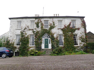
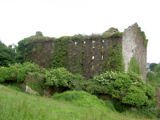
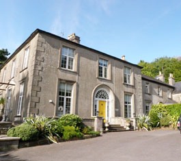
| Castle Bernard | Described by Lewis in 1837 as " a stately mansion, built in 1806, adjacent to the site of the former castle" and originally known as Castle Mahon. It was the seat of the Bernard family in the late 1770s and 1780s and then known as Castlebernard. Occupied by Viscount Bernard at the time of Griffith's Valuation and valued at £120. It was burnt in June 1921 and is now a ruin adjacent to Bandon Golf Club. |

|
| Roundhill | The house and demesne at Roundhill were offered for sale in the Encumbered Estates Court in 1855. The sale notice indicates that the property was being leased by the Bowens to the Earl of Bandon's estate. Leet refers to Roundhill as the residence of Rev. Kenny in 1814. The building is now in use as part of Bandon Grammer School. |
|
| Richmount | Richard Sealy held this property in perpetuity in the early 1850s when it was valued at £45.Lewis also notes it as his seat in 1837. It had been a residence of the Sealy family since the early eighteenth century. The site is now occupied by Bandon Grammer School. | |
| Clancool House | Held in fee by Thomas W. Hewitt at the time of Griffith's Valuation, when it was valued at £25. Lewis refers to Clancool as the seat of Mrs. Gillman in 1837. This house is still extant. |
|
| Curravarahane House/Bernard Court | William Smith Bernard was leasing this property from the Bandon estate at the time of Griffith's Valuation, when it was valued at £42. Lewis notes the residence of W.S. Bernard, as The Farm, in 1837. It was labelled Bernard Court on the 25-inch Ordnance Survey map of the 1890s. It is still extant. |

|
| Gurteen Old Mill | Samuel Levis was leasing this property, including a mill, valued at £10, to John Crowley, at the time of Griffith's Valuation. Earlier, in 1786, Wilson refers to a property at Gurteen owned by Mr. Gilman. It is labelled Gurteen Old Mill on the first edition Ordnance Survey Map. It does not appear on the 25-inch Map of the 1890s and there is no trace of it now. | |
| Mayfield | In the 1770s and 1780s, Poole Esq was resident at Knocknaville near Bandon. Thomas Poole held Mayfield in perpetuity at the time of Griffith's Valuation, when it was valued at £48. Both Lewis, in 1837, and Leet, in 1814, also refer to it as his residence. Mayfield was burnt in June 1921 during the War of Independence when it was the residence of Hewitt R. Poole. It is now a ruin. |
|
| Hare Hill | At the time of Griffith's Valuation, Hare Hill was being leased by Thomas Beamish from the Poole estate, when it was valued at £20. Lewis notes it as the seat of J. Beamish in 1837. The National Inventory of Architectural Heritage notes that it was partially damaged by fire in the early 1920s but subsequently restored. |

|
| Sun Lodge/Hoe Lodge | Sun Lodge was being leased by James Hallinane from the Poole estate in the 1850s when it was valued at £13 10s. Lewis refers to it as the seat of W. McCarty in 1837. It is labelled Hoe Lodge on the 25-inch Ordnance Survey map of the 1890s, the name by which it is still known. |
|
| Milton House (Bandon) | Elizabeth Swete was leasing Milltown from Miss McCarthy at the time of Griffith's Valuation, when it was valued at £22. It is labelled Miltown House on the 1st edition Ordnance Survey map but as Milton House on the 25-inch ediiton of the 1890s, the name by which it is still known. The National Inventory of Architectural Heritage suggests it was built for the Allman family. |
|
| Overton | Overton House was held by Miss McCarthy at the time of Griffith's Valuation, when it was valued at £32. Lewis notes it as the residence of Col. Clerke in 1837. it is a house principally associated with the Allman family. The adjacent cotton mill is described as "disused" on the 25-inch Ordnance Survey map of the 1890s. Both buildings are now in ruins. |
|
| Roundhill House | This house was the home of Travers Esq in the 1770s. The representatives of Robert Travers were leasing this property to Timothy Crowley at the time of Griffith's Valuation, when it was valued at £198 including the nearby mill complex. Both buildings are still extant. |
|
| Kilhessan Lodge | James Jellett was leasing this house from the Poole estate in 1851 when it had a valuation of £13. A house is still extant at the site. | |
| Callatrim Retreat/Callatrim House | Held by Jacob Biggs from the Devonshire estate in 1851 when it had a valuation of £10. It is labelled Callatrim Retreat on the 1st edition Ordnance Survey map but as Callatrim House on the later 25-inch map of the 1890s. A house and extensive farm buildings are extant at the site. | |
| Mount Bernard | William Bernard was leasing this property from the Devonshire estate at the time of Griffith's Valuation, when it was valued at £15 10s. A house is still extant at this site. |

|
| Carhoon House | Thomas Bullen was leasing Carhoon from the Devonshire estate in 1851 when it was valued at £10 10s. It is still extant and part of a large farming enterprise but not occupied. |

|
| Coolfadda House | Alexander Swanston was leasing Coolfadda House from the Devonshire estate in 1851 when it had a valuation of £30. Lewis refers to it as the seat of B.Popham in 1837. A house still exists at the site. |
|
| The Retreat (River View House) | In 1851 Thomas K. Sullivan was leasing this property from the Devonshire estate when it had a valuation of £38. It is labeled Riverview House on the 1st-edition Ordnance Survey map but has changed to The Retreat by the 1890s. It is still extant. |

|
| Hill House (Bandon) | William C. Sullivan was leasing this house from the Devonshire estate in 1851 when it was valued at £20. It is labelled Barrett's Hill House on the 1st edition Ordnance Survey map but as Hill House on the 25-inch edition of the 1890s. It does not appear to be extant now. | |
| Kilbrogan Glebe | Held by Rev. Charles B. Bernard from the Ecclesiastical Commissioners in 1851 when it had a valuation of £34. It is still extant and now known as Mount Grellan House. |

|
| Park View (Bandon) | In 1851 Henry Cornwall held a property valued at £22 in perpetuity. It is also recorded as his residence by Lewis in 1837. By the publication of the 25-inch Ordnance Survey map of the 1890s it has become known as Ardnacarrig. It is still extant and occupied. |
|
| Janeville (Bandon) | Rev. Henry Gillman was leasing this property from the Cornwall family in 1851 when it had a valuation of £33. It is labelled Janeville on both the 1st and 25-inch Ordnance Survey maps. The house is still extant and now known as Eversleigh House. |
|
| Laragh House | In 1851 Edmund Murphy was leasing this property, then valued at £28, from the Devonshire estate. There was a mill adjacent. Lewis records it as the residence of I. Swanton in 1837. It is still extant and part of a large farming enterprise. |

|
| Mishells House | In 1851 being leased by William A. O'Connor from the Devonshire estate and valued at£16. There is an extant house at the site. | |
| Shinagh House | Leased by Thomas Banfield from the Devonshire estate in 1851 when it was valued at £18. Local sources suggest that the Banfields had resided there since at least the 1690s. This building is labelled Shinagh House on the 1st edition Ordnance Survey map but has disappeared by the 1890s when Shinagh House is shown some distance north-east of the original site at W457555. A business centre now occupies the site. | |
| Woodfort (Bandon) | John Ottley was leasing Woodford from the Alcock family in 1851 when it was valued at £25. It is still extant. | |
| Sunville (Kilbrittain) | James F. Sweeney was leasing this property from William B. Bernard's estate at the time of Griffith's Valuation, when it was valued at £10. It included Knockavortelig Mill which does not appear on the 25-inch map of the 1890s. A house still exists at the site. | |
| Knockbrown | A property built after the 1st Ordnance Survey was published. It was held in fee by Thomas B. O'Callaghan in 1851 when it was valued at £8. There is still an extant house at the site. | |
| Cornwall's Brewery | Henry Cornwall held this property in perpetuity at the time of Griffith's Valuation when it was valued at £180. It is labelled Watergate Brewery on the 25-inch Ordnance Survey map of the 1890s. The former miller's house is still extant and now known as The Haven. |
|
| Hill House (Bandon) | William C. Sullivan was leasing this house from the Devonshire estate in 1851 when it was valued at £20. It is labelled Barrett's Hill House on the 1st edition Ordnance Survey map but as Hill House on the 25-inch edition of the 1890s. It does not appear to be extant now. | |
| Summerhill (Bandon) | A house built after the publication of the first Ordnance Survey. At the time of Griffith's Valuation, Mrs. Eliza Baldwin was leasing a property at Knockbrogan from the representatives of J. Lovell. It was then valued at £8. Summerhill House is still extant. |
|