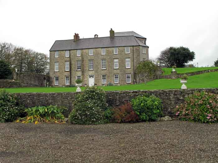
Wood View
Houses within 5km of this house
Displaying 18 houses.
Houses within 5km of Wood View
Displaying 18 houses.
| House name | Description | |
|---|---|---|
| Brooklodge House | A house and paper mill valued at £30 held by Mary Eliza Phair from the Reverend Robert Bury at the time of Griffith's Valuation. This Phair family were involved in paper mills in a number of townlands in this locality. | |
| Brookville | Home of Cornelius O'Callaghan who held it from the Reverend Robert Bury in the mid 19th century. The buildings were valued at £35. |

|
| Blossomgrove | Blossomgrove was the residence of William Casey in the early 1850s. He held the house valued at £22 and 335 acres from Simon Dring. A house is still extant at the site. | |
| Butlerstown | Nathaniel C. Martin held a house, offices, foreman's house and spade factory valued at £25 from Francis Beamish. The property is labelled Butlerstown House on the 25-inch Ordnance Survey map of the 1890s when the spade factory is no longer visible. There is still an extant house at the site. | |
| Corbally | ''Burke's Irish Family Records'' describes the Sheehys of Corbally House from about the late 18th century. In the mid 19th century the house was occupied by William J. Sheehy, second son of Bryan Sheehy of Corbally House, died 1806. The buildings were valued at £27 and the property was held from the Reverend Edward Newenham. This house was named 'Mill View' on the first Ordnance Survey map. Mill View was still occupied by Sheehys when it was advertised for sale in 1871. | |
| Maryborough | The sale rental for the Mannix estate states that this house was built in 1816 at a cost of £3,000. Occupied by J. Wallis in 1837 and by Henry Mannix in the early 1850s. Mannix held the property from the representatives of the Reverend Robert Dring and the buildings were valued at £28. |

|
| Riverstown | An early 18th century house with fine plasterwork by the Francini brothers, the seat of the Browne family for two and a half centuries. The Brownes were still occupying the house in 1837 but John Carmichael is recorded as the occupier in the early 1850s when it was valued at £32.10 shillings. Restored in the 1960s by the Dooleys with help from the Irish Georgian Society. |
|
| Glyntown House | Unoccupied in the early 1850s, this house was held by Eliza McCaul from William B. Hoare. It was valued at £35. Bence Jones writes that this house, now demolished, was built by Samuel McCall and was owned in the 20th century by the Dring family. | |
| Ballinglanna | Occupied by J. Newsom in 1814 and E. Newsom in 1837. Edward Newsom held this house from Eliza McCaul and Louis Denay at the time of Griffith's Valuation when it was valued at £24. This house is named Glenville on the first Ordnance Survey map. |

|
| Ashton Grove | This house is marked Ashton Grove on the first Ordnance Surve map. John Cotter was the proprietor of Ashton, Cork, in 1814 and T. Cleary of Ballingohig in 1837. Thomas J. Cleary held the property from Henry Braddell at the time of Griffith's Valuation when the buildings were valued at £22. Cleary held a cornmill from Braddell in the townland of Kilrussane. James Fitzgerald held 122 acres of untenanted land and buildings valued at £26+ in 1906. |
|
| Mitchellsfort/Fellfort | This house was the home of Mitchell Esq in the 1770s and 1780s. Occupied by Brooke Brazier in 1814 and by his son Henry B. Mitchell in the early 1850s. Henry B. Mitchell owned the property in fee and the buildings were valued at £52+. Slater noted it as the residence of R.L. Fell in 1894, now demolished. | |
| Hermitage | A house valued at £18, occupied by Eliza Martin and held from Robert Webb at the time of Griffith's Valuation. In the 20th century the home of Edmund Glen Browne. |

|
| Sarsfieldscourt [Old] | In 1837 Lewis refers to Sarsfieldscourt as an ancient mansion "formerly belonging to the Sarsfield family but now to Mr Rutland [Putland] of Dublin". On the first Ordnance Survey map one building is marked as "in ruins". Another building also named Sarsfield's Court is marked closer to the Glashaboy River. At the time of Griffith's Valuation Charles Putland junior was recorded as occupier, holding the house valued at £13 from his father Charles Putland. This latter property is labelled Beechmount on the 25-inch Ordnance Survey map of the 1890s. A property labelled Sarsfieldcourt House is also located in the townland on the later map [W723779]. It is no longer extant and St.Stephen's Hospital now occupies the grounds. | |
| Park Farm House | Henry Morrogh of Park Farm was a younger son of James Morrogh of Cork. He was resident at Park Farm in 1837 and in the early 1850s when the house was valued at £35 and held in fee. He married Helena Power. Mrs Helen Morrogh owned 828 acres in county Cork in the 1870s. | |
| Lauriston | A house valued at £40 at the time of Griffith's Valuation and held by Nicholas D. Murphy from Joseph Anderson. | |
| Ballyphilip House | This property was leased to Samuel Adams Austen and occupied by John Forrest in the early 1850s. When the Newenham's fee of Ballyphilip was for sale in 1865 David Cagney was resident. A house still exists at the site. | |
| Trantstown | A Trant home in the 18th century, occupied by Mrs Pepper in 1837 and by James Barry in the early 1850s. He held the house valued at £8+ from Lady A.H. Fitzgerald. Buildings are still located at this site. | |
| Corbally South | Catherine Delany held buildings valued at £11 from William J. Sheehy in Corbally South at the time of Griffith's Valuation, with 148 acres. Buildings are still located at this site. |