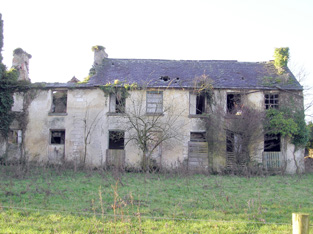
Clonkeen House (Barrington)
Houses within 5km of this house
Displaying 14 houses.
Houses within 5km of Clonkeen House (Barrington)
Displaying 14 houses.
| House name | Description | |
|---|---|---|
| Clonshavoy | Located on the Barrington estate this house was occupied by Caleb Powell and valued at £15 at the time of Griffith's Valuation. Bence Jones describes Clonshavoy as a single storey early 19th century house in the "cottage" style. In the 20th century it was the home of the last Barrington to live in the Limerick area. The Irish Tourist Association surveyor writes in 1944 that the house was interesting as it was the remains of a very old Elizabethan house. He says that more than half the house was pulled down as it was unsafe "and the present eastern wing is a reconstruction". This house is still extant. |

|
| Abington House | Abington House in the townland of Dromeliagh is marked on the first Ordnance Survey map. In 1786 Wilson states "at Abingdon, is a very pleasant seat of Sir Nicholas Lawless". At the time of Griffith's Valuation a house valued at £17 was occupied by Michael Apjohn in this townland. In the 1860s this house was occupied by John Connell Fitzgerald and his wife Margaret (Apjohn). ''The Limerick Chronicle'' of 1 Oct 1872 records the death of Mary Anne Apjohn of Abington House, widow of Michael Apjohn. The property was held from Lord Cloncurry. A ruined house is still extant at the site. |
|
| Farnane House | Located on the Cloncurry estate Farnane was the home of the Costelloe family from at least 1837. Occupied by Thomas Costelloe in the early 1850s and valued at £12+. It is labelled Farnane House on the 1st edition Ordnance Survey map but is not labelled on the later 25-inch edition of the 1890s. It is no longer extant. | |
| Wilton | In 1786 Wilson refers to Wilton-Hall as the seat of Mr. Perceval. A house labelled Wilton is shown on the 1st edition Ordnance Survey map. It was occupied by George Duhy at the time of Griffith's Valuation, valued at £14 and held from Lord Cloncurry. On the 25-inch map of the 1890s this property is labelled Wilton Constabulary Barracks. It is no longer extant. | |
| Raheen | A steward's house on the Bourke estate was recorded at Raheen in the early 1850s. It was valued at £11+. | |
| Thornfield | Leet records Thorn-field as the residence of Thomas Thornley in 1814. By the mid 19th century it was the residence of Sir Richard Bourke held by him in fee and valued at £25. The Ordnance Survey Field Name Book refers to Sir Richard Bourke repairing the house circa 1840. It was 2 storeys high, 60x50 feet. This house has remained in the possession of Sir Richard's descendants into the 21st century. |

|
| Highpark | A property in the possession of the Gabbett family from the early 18th century. Described in the Ordnance Survey Name Book as having a "decayed appearance", this three-storied house was built between 1759 and 1789. The house, valued at £10, was vacant at the time of Griffith's Valuation. It is still extant. |

|
| Ahabeg | Built in 1827 this house was the home of the Rose family in the 19th century. It was occupied by Michael Lloyd who held it from Counsellor Richard Rose circa 1840. The residence of Richard Rose held by him in fee at the time of Griffith's Valuation and valued at £18+. Aghabeg is still extant and well-maintained. | |
| Ballyclogh House | The Ordnance Survey Field Name Book refers to the building of this house in 1822 by Henry Rose as a cost of £600. Occupied by P. Cudmore in the 1830s and by Henry Rose at the time of Griffith's Valuation who held the property from the representatives of Samuel Dixon [Dickson]. The buildings were valued at £9+ in the 1850s. Ballyclogh is still extant. |

|
| Maddyboy | Occupied by John Burke in 1814, by Captain Wickham in 1837 and by Benjamin Lucas in the early 1850s. The buildings were valued at £14 and the property held from John Lucas. | |
| River Ville [Mulkear] | Built circa 1800 and the seat of Arnold Hill circa 1840 this house was occupied by Samuel F. Dickson at the time of Griffith's Valuation and held by him from William D. Farrer with 206 acres, The buildings were valued at almost £16.The house is labelled River Ville on the 1st edition Ordnance Survey map but as Mulkear on the 25-inch edition of the 1890s. A house is still extant at the site. | |
| Mulkear | Built by the Reverend J. Crampton in 1812 at a cost of £3,000. He was still resident in 1837. Occupied by George Gough in the early 1850s, held by him from John Tuthill and valued at £35. Later the home of Samuel Frederick Dickson. Home of Martin Edward Patrick White circa 1900. On the 25-inch edition Ordnance Survey map the house at this site is labelled Woodstown House. An earlier Woodstown House is described as "in ruins" in the adjoining townland of Woodstown on the 1st edition Ordnance Survey Map. In 1786 Wilson refers to a house at "Gran" as the seat of Mr.Gough, which may refer to an earlier house in this area. This property is now part of a health services facility. | |
| Rich Hill | The residence of the Howley family in the 19th century, held by them in fee and valued at £39 in the early 1850s. Rich Hill was also the childhood home of Captain William O'Shea. |

|
| Woodsdown | This house was the home of the Gough family in the late 18th and early 19th centuries. It was occupied by Matthew O'Brien in 1814. The Ordnance Survey Field Name Book states that this house was built by the ancestors of Major Gough and "it is now in ruins". It is marked as "in ruins" on the first Ordnance Survey map. Another house was later built by the Bannatynes and occupied by the Goodbody family in the early 20th century. Now run by the Sisters of Charity as St Vincents Centre for persons with intellectual disabilities. |