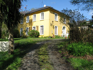
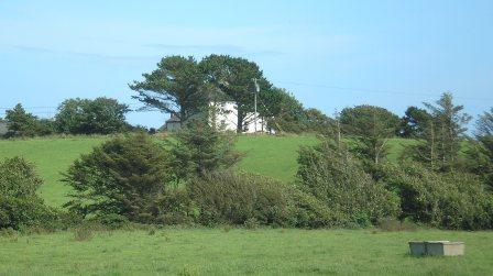
Carrigboy
Houses within 15km of this house
Displaying 51 houses.
Houses within 15km of Carrigboy
Displaying 51 houses.
| House name | Description | |
|---|---|---|
| Westfield | At the time of Griffith's Valuation, Margaret Long was leasing this property to Rev. John Coppinger when it was valued at £13 15s. The house is still extant and occupied. |
|
| Whitehall | Edward Townsend held this property in fee at the time of Griffith's Valuation, when it was valued at £22. Lewis noted it as the residence of S. Townsend in 1837. In 1906 it was owned by the representatives of Samuel R. Townsend and valued at £21. Bence-Jones indicates that it later became the property of the Alleyne family. The Irish Tourist Association reported in the early 1940s that it was still occupied at that time. |

|
| Marsh House | Robert Tighe was leasing this property to William Jago at the time of Griffith's Valuation, when it was valued at £14 5s. A house is still extant at the site. | |
| Springville | Thomas S. Fleming was leasing this property to Richard Long at the time of Griffith's Valuation, when it was valued at £7 15s. A house is still extant at the site. | |
| Dromore Cottage | Daniel Welply held this property in fee at the time of Griffith's Valuation, when it was valued at £5. It is labelled Dromore Cottage on the 25-inch Ordnance map of the 1890s. It is still extant and occupied. |
|
| Aghadown House | At the time of Griffith's Valuation, Aghadown House, owned by William Jago, was unoccupied and valued at £8. Lewis had noted Aghadown as the seat of H. Becher in 1837. [The 25" Ordnance Map shows a second house, also called at Aghadown House, at W049334] The original Aghadown House is shown on Taylor and Skinner's 1783 map as a seat of the Banfield family and Wilson refers to it as the seat of "Benjamin Bonsfield" in 1786. In the early 1940s the Irish Tourist Association survey noted that "of this mansion, one ivy-covered gable and the gazebo remain". The National Inventory of Architectural Heritage notes that the extant building may previously have been the steward's house when the original house was still occupied. |

|
| Gortnascreeny House | Lewis notes Gortnascree House, parish of Caheragh, as the residence of A. O'Driscoll in 1837. At the time of Griffith's Valuation the property was being leased by Thomas Goggin from the Becher estate and had a value of £4 10s, In 1906, a property valued at £10 and owned by Sir John Becher was reported at "Gortnadrohid" but there is no townland with this name in Caheragh parish. There is still an extant house at this site. | |
| Greenmount House | Daniel Connor was leasing this property to Thomas Atridge at the time of Griffith's Valuation, when it was valued at almost £9 and stood on a holding of 300 acres. In 1837 Lewis recorded Greenmount as the seat of Captain Long but in 1814 Leet refers to it as the seat of Thomas Atbridge [sic]. There is still a house at this site, undergoing renovation in 2009. |
|
| Roaring Water Cottage | At the time of Griffith's Valuation, John F. Townsend was leasing this property to Frances Long, when it was valued at £8. Lewis mentions Roaring Water House as the residence of J. O'Sullivan in 1837. The house is still extant and occupied. | |
| Ardogeena House | At the time of Griffith's Valuation, Richard T. Evanson was leasing this property to Florence McCarthy when it was valued at £10. In 1837, Lewis noted the house as the seat of R.T. Evanson. It is still extant and occupied. |
|
| Four Mile Water Court or Durrus Court | Rev. Alleyn Evanson was leasing this property from the Earl of Bandon's estate at the time of Griffith's Valuation, when it was valued at £15. It is labelled Four Mile Water Court on the 1st edition Ordnance Map and Durrus Court on the later 25-inch edition. In 1837, Lewis recorded it as Four Mile Water Court, the seat of A. Evanson. It is still extant. | |
| Durrus Glebe | Rev. James Freke was leasing this property from the Ecclesiastical Commissioners at the time of Griffith's Valuation when it was valued at £20. Lewis records it as the residence of Rev. Alcock in 1837. The house is still extant and occupied. |
|
| Blair's Cove | At the time of Griffith's Valuation, this property was held in fee by Richard L. Blair and valued at £20. In 1837 Lewis had noted it as the seat of R.L. Blair. Leet refers to it as the seat of Cornelius O' Connor in 1814. It was offered for sale, as part of the Blair estate sale, in April 1866 when it was noted that "with judicious outlay in repairs it might be rendered very comfortable". The house is still extant and now houses a restaurant and luxury accommodation. See www.blairscove.ie |
|
| Friendly Cove | Richard T. Evanson was leasing this property from John B. Gumbleton at the time of Griffith's Valuation, when it was valued at £24. Stores adjoining the property were valued at £6. Leet records this property as the residence of Nathaniel Evanson, jnr. in 1814. The house is still extant and in 2009 was offered for sale. |
|
| Fort Lodge | John B. Gumbleton was leasing this property to Richard Donovan at the time of Griffith's Valuation, when it was valued at £7. In 1837 Lewis noted it as the seat of R. O'Donovan. It is now in ruins. | |
| Toormore Cottage | Rev. William Fisher held this property in fee at the time of Griffith's Valuation, when it was valued at £12 10s. Lewis had recorded it as the seat of J. Baillie in 1837. | |
| O'Donovan's Cove | Timothy O'Donovan held this property in fee at the time of Griffith's Valuation, when it was valued at £12. Lewis recorded it as the seat of T.O'Donovan in 1837. It is described as "in ruins" on the 25-inch map of the 1890s and no trace remains now. | |
| Ardmanagh House | John Limerick was leasing this property to Thomas Nicholls at the time of Griffith's Valuation when it was valued at £10. Substantial modern building has taken place in the area. | |
| Ballydehob Cottage | At the time of Griffith's Valuation, Patience Noble was leasing this property to William J. Swanton, when it was valued at £8 10s. In 1906 it was owned by Robert Swanton and valued at £10 10s. | |
| Rock Cottage (Skull) | James O'Callaghan was leasing Rock Cottage from the Earl of Bandon's estate at the time of Griffith's Valuation, when it was valued at £11. In 1837 Lewis had recorded it as the residence of J. O'Callaghan. James O'Callaghan owned over 450 acres in the area in the 1870s. Operated as a guesthouse in the later twentieth century and offered for sale in 2009. |

|
| Cappagh House (Skull) | Thomas S. Cave held this property in fee at the time of Griffith's Valuation, when it was valued at £20. Named as Cappagh House on the 1st edition Ordnance Map but not shown on the later 25-inch map. |
|
| Seafort | Mountifort Longfield was leasing this property to Stephen Browne at the time of Griffith's Valuation, when it was valued at £9 10s. May possibly have been owned by William Hull in 1814. In 1894, Slater refers to it as a residence of Mountifort Longfield. The house is still extant, together with extensive farm buildings. |

|
| Dunbeacon House | Richard Townsend held this property in fee at the time of Griffith's Valuation, when it was valued at £11 5s. In 1906 it was also the property of Richard Townsend and valued at £8. | |
| Rickfield Cottage (Skull) | Hugh Swanton was leasing this property from the Connor estate at the time of Griffith's Valuation, when it was valued at £5. Buildings are still extant at the site. | |
| Rickfield (Skull) | At the time of Griffith's Valuation, Robert Swanton was leasing this property from the Connor estate when it was valued at £6 5s There are still buildings at the site. | |
| Leamcon House | At the time of Griffith's Valuation, William Hull held this property in fee when it was valued at £20. It had also been noted by Lewis as the seat of the Hull family in 1837. In 1814 it was the residence of R.E. Hull. The 1st-edition Ordnance Map also indicates the site of Old Leamcon House as well as a defensive battery. Leamcon House is still extant and occupied. |
|
| Lissacaha Cottage | Phillip Somerville held this property in fee at the time of Griffith's Valuation, when it was valued at £12 10s. It is labelled "Lissacaha Cottage" on the 1st edition Ordnance Map but has become "Prairie Cottage" on the later 25-inch map. In 1906 it was owned by Thomas Phillip Somerville and valued at £15 5s. It is no longer extant. | |
| Meenvane | John Limerick was leasing a property to Nathaniel Lannon (?) at the time of Griffith's Valuation, when it was vaued at £13. This property appears to have been situated on the main street in the village of Skull. | |
| Horse Island | At the time of Griffith's Valuation, Thomas Cave is recorded as holding a house in fee valued at £10 at Horse Island. No house is labelled on the 1st-edition Ordnance Map. The island was notable for its concentration of copper mines. | |
| Lowertown Corn Stores | Daniel McCarthy was leasing a building described as "corn stores" from the Hull estate at the time of Griffith's Valuation, when it was valued at £10. It is not evident on the 25-inch map of the 1890s. | |
| Reenmeen Cottage | Leased by Robert White from the Bantry estate in 1852 when it was valued at £11+. Named as Reenmeen Cottage by Lewis who notes it as the seat of R. White in 1837. Buildings still exist at the site. A house named Glengarriff Cottage (V939564) appears on the 1st edition Ordnance Map in this townland but is not visible on the later 25-inch map. | |
| Glengarriff or Eccles Hotel | Thomas Eccles was leasing this property from the Earl of Bantry's estate in 1852 when it was valued at £21+. It is labelled on the 1st Edition Ordnance Survey Map as Glengarriff Hotel but is better known now as the Eccles Hotel, one of Ireland's oldest hotels. In April 1875, following the death of Thomas Eccles, the hotel was offered for sale in the Landed Estates Court. A detailed history is available at www.eccleshotel.com. |

|
| Ardnagashel House | Samuel Hutchins held this property in fee in 1852 when it was valued at almost £23. Lewis noted it as the seat of A. Hutchins in 1837. In 1906 it was owned by Samuel N. Hutchins and valued at £30. The original house has been demolished and the stableyard converted to self-catering accommodation. The Irish Tourist Association survey of the 1940s mentions that the grounds contained some fine trees including a cork tree which came originally from Kew Gardens. |
|
| Ballylicky House | Arthur Hutchins was leasing this house from the Earl of Kenmare's estate in 1852 when it was valued at almost £14. In 1837 Lewis refers to it as the seat of S. Hutchins. Later associated with the Graves family. The Irish Tourist Association survey of the 1940s noted that it was already being run as a guesthouse at that time and it is now a luxury hotel. |

|
| Dunnamark House | Leased by Alicia Tisdall from Samuel Hutchins at the time of Griffith's Valuation, when it was valued at £8 5s. In the 1940s the Irish Tourist Association survey noted that it was the residence of Dr. Nunan. There is still an extant house at the site. | |
| Dunnamark Mill | Michael Murphy was leasing this property, including a mill, from the Kenmare estate in 1852, when it was valued at £35. The building is labelled Barytes Mill on the 25-inch Ordnance Survey map of the 1890s. It is now a ruin. | |
| Gurteenroe House | John Shea Lalor was leasing Gurteenroe from the Kenmare estate in 1852 when it was valued at £10 10s. Lewis noted it as his residence in 1837. It appears to have been occupied by a Gallway family in the 1780s as both Taylor and Skinner and Wilson mention a residence of that family in this area. It is now a ruin. | |
| Newtown (Bantry) | Held in fee by the Earl of Kenmare's estate in 1852 when it was valued at £8 5s. Lewis refers to it as the seat of M. Murphy in 1837. There is still an extant house at the site. | |
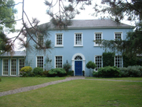
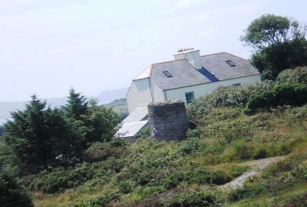
| Reenydonagan House | Leased by Roger O'Sullivan from the Kenmare estate in 1852 when it was valued at £12. Lewis notes it as the seat of D. O'Sullivan in 1837. The house is still extant and operates as a guesthouse. |

|
| Ivy Cottage (Bantry) | Jeremiah O'Connell was leasing this property from Robert E. White at the time of Griffith's Valuation, when it was valued at £24. A substantial farmyard was located nearby. By the later nineteenth century the house appears to have been known as Beach Cottage. A slightly later building, known as Ardeevin House, exists at this site now. |

|
| Caherdaniel House (Bantry) | Leased from the Bantry estate by John Cotter at the time of Griffith's Valuation, when it was valued at almost £9. Occupied buildings still survive at the site. | |
| The Vicarage (Bantry) | Rev. John Murphy was leasing the Vicarage from the Bantry estate at the time of Griffith's Valuation, when it was valued at almost £21. The house is still extant and occupied. |

|
| Drombrow House | Occupied by Hamilton White, leasing from the Bantry estate, in 1852, when it was valued at almost £16. Lewis records "Drumbree Cottage" as the seat of J. White in 1837. Drombrow was the property of Arthur B. Wilkinson in 1906 and valued at almost £15. |
|
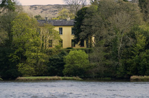
| Glengarriff Castle | Sarah White was leasing this property from the Bantry estate at the time of Griffith's Valuation, when it was valued at almost £36. In 1837, Lewis described it as "Glengarriff Castle, the seat of Captain White, is a spacious elegant mansion". Local sources suggest the Castle was built in the 1790s by Simon White, a brother of the 1st Earl of Bantry. Noted by Leet as the seat of Simon White in 1814. In 1894 Slater refers to it as the seat of R.H.E. White. It functioned as a resort until the 1970s. Plans are currently in progress to restore the building. |

|
| Bay View (Bantry) | Samuel Daly was leasing this property from the Earl of Bantry's estate in 1852 when it was valued at over £32. It is not named on the 1st edition Ordnance Survey Map but appears as Bay View on the 25-inch map of the 1890s. There is still an extant house at the site. | |
| Inchiclogh House | Hamilton White held this property in fee in 1852 when it was valued at almost £34. Lewis refers to it as the seat of R. White in 1837. It is included in the Encumbered Estates Sale Notice of December 1852, which indicates that it was held by Elizabeth White, a widow, by lease from the Court of Chancery. The property does not appear on the 25-inch Ordnance Survey map of the 1890s. | |
| Coomhola Lodge (Sans Souci) (Bantry) | Occupied by Richard E. White at the time of Griffith's Valuation, when it was valued at £8. It is labelled as Sans Souci on the 1st edition Ordnance Map but as Coomhola Lodge on the 25-inch edition of the 1890s. Local sources indicate it was formerly a hunting lodge for the Bantry Estate. It is still extant. | |
| Reenadisert Court | Leased by Robert Warren from the Bantry estate at the time of Griffith's Valuation when it was valued at almost £6. It was originally a seventeenth century fortified house built by the O'Sullivans and is now in ruins. A second property, Reenadisert Cottage (W000531), appears on the 25-inch Ordnance Survey map of the 1890s but this has now disappeared. |

|
| Bantry House | Bantry House was held in fee by the Earl of Bantry at the time of Griffith's Valuation, when it was valued at £125. The house history indicates it has been the home of the White family since about 1765 when Richard White purchased what was then Blackrock House. Wilson still refers to it by the latter name in 1786 but it is named Bantry House on the 1st edition Ordnance Survey map of the 1830s. The Irish Tourist Association survey of the 1940s contains a detailed description of the house's interior at that time. Bantry House has been open to the public since 1946 and a prestigous music festival is held there each summer. For more information see www.bantryhouse.com. |

|
| Trawnahaha | Elizabeth Vickery was leasing this property on Whiddy Island from the Earl of Bantry's estate in 1852 when it was valued at £14. It is not named on the 1st edition OS map and the grid reference is approximate. | |
| Derreennatra Manor | This house does not appear on the 1st edition Ordnance Survey map nor is it recorded in Griffith's Valuation when the surrounding property was owned by Dr. Thomas Hicks. It is labelled Derreennatra Manor on the 25-inch map of the 1890s. A house still exists at the site. |