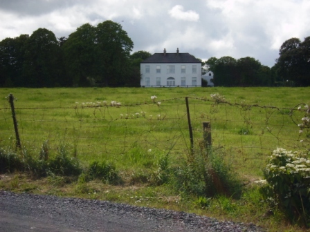
Liskennet
Houses within 5km of this house
Displaying 7 houses.
Houses within 5km of Liskennet
Displaying 7 houses.
| House name | Description | |
|---|---|---|
| Kilmore | Brian de Breffny writes that the back section of Kilmore House is part of the 17th century house built by the Moncktons. The front part was built by the Tuthills in the mid 18th century. George Tuthill purchased the house from Edward Monckton in 1737. The Tuthills had previously held it on lease. Occupied by Thomas Lynch in 1814 and by Colonel William Jones in the early 1850s, when the property was held from Elizabeth Tuthill and valued at £15. In 1906 Kilmore was the residence of Anne Isabel O'Grady. This house is still extant and occupied. |
|
| Lisduane | The seat of Walter Mason, situated on the estate of General Dixon [Dickson], circa 1840. Occupied by John [Leland] Mason at the time of Griffith's Valuation and held by him from the Court of Chancery. The buildings were valued at £12. William Harte Mason of Cooleen, Bruree owned 190 acres in the 1870s. A house and farm are still extant at the site. | |
| Coolrus House | The residence of Richard Harte circa 1840 and of James Lynch in the early 1850s who held the property and 186 acres from the Court of Chancery. The house has diminished in size by the publication of the 25-inch edition Ordnance Survey map in the 1890s and it is no longer extant. | |
| Cherrygrove | Cherrygrove was the home of Edward Cripps in 1814 and of J. Barry in 1837. At the time of Griffith's Valuation it was occupied by Edward John Sheehy who held the property from Robert Harding. The buildings were valued at £21+. The Misses Sheedy were still in residence in the 1940s. A building is still extant at the site. | |
| Belview/Bellevue | A home of the Yielding family, occupied by Richard M. Yielding in 1814 and 1837 and by Timothy Hartigan who held the property from James Barry at the time of Griffith's Valuation. The buildings were valued at £13 at that time. Bought by the Delmeges in the early 1850s. The original house is not extant. | |
| Dollas Upper | Mary Blake occupied a house valued at £12+ and 48 acres on the Langford estate at the time of Griffith's Valuation. This property is labelled Dollas House on the Ordnance Survey map published in 1942. Unroofed buildings are still extant at the site. | |
| Harding Grove | Occupied by G. Harding in 1814 and H. Harding in 1837. The seat of Mr Harding at the time of the first Ordnance Survey. By the time of Griffith's Valuation a Neill McDonald was in possession of Harding Grove. Neil Macdonald of Steyle Park, Bruree owned 354 acres in county Limerick in the 1870s. Francis H. Wyse is recorded as the occupant of Harding Grove in 1906. |

|