Friarstown (Grange)
Houses within 5km of this house
Displaying 17 houses.
Houses within 5km of Friarstown (Grange)
Displaying 17 houses.
| House name | Description | |
|---|---|---|
| Cahercorney | Not named on the the 1st edition Ordnance Survey map, this house was the residence of Henry Croker at the time of Griffith's Valuation. It was valued at £10+ and was held from John Croker. Earlier, in 1786, Wilson refers to it as the seat of Mr. White. A farm is extant at this site now. | |
| Fedamore | A house known as Fedamore Cottage is marked on the first Ordnance Survey map. By the early 1850s John and Edward Synan were the occupiers of a house valued at £27 in Fedamore townland, which they held from Colonel Wyndham. The property is shown as Fedamore House on the 25-inch map of the 1890s, by which time it was the residence of J.G. Kelly. It is still extant and occupied. | |
| Loughgur Castle | In 1786 Wilson refers to Lough-Gur as the seat of Henry Baylee. This house was ccupied by John "Boylie" in 1814 and by Miss Bailie in 1837. In the early 1850s William Evans was resident. He held the house valued at £11 from the Count De Salis. It was adjacent to the remains of a tower house known as Bouchier's Castle. The property at this site is labelled "Lough Gur Farm" on the 25-inch map of the 1890s. The book edited by Mary Carbery, "The Farm by Lough Gur", published in 1937, contains a description of the Baylee property at Loughgur. The original Bayley house is no longer extant. | |
| Grange Hill | Leet records Grange-Hill as the residence of Edward Croker in 1814. Edward John Croker was resident at the time of the first Ordnance Survey. It was a residence of the Count De Salis at the time Griffith's Valuation. The Count held it in fee and the buildings were valued at £27. The Count was still the occupier of Grange in 1906. Owned by Colonel and Mrs Galloway in 1942. The house is now known as Loughgur. |
|
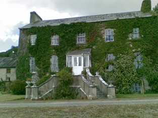
| The Grange | The home of the Grady/O'Grady family in the 18th and 19th century. In 1786 Wilson describes it as "the beautiful and well-improved seat of Standish O'Grady". It was inherited by the Crokers in 1861. Occupied by Standish [O'] Grady in 1814 and Henry O'Grady in 1837 and at the time of Griffith's Valuation. The buildings were valued at £77 and the property was held in fee. In 1894 it was noted by Slater as the seat of Captain Edward Croker. This house was described as in very good repair even though it had not been occupied for a number of years preceding the Irish Tourist Association survey of 1942. The house is now a ruin. |
|
| Rawleystown Court | Lewis writes that "in the parish of Cahercorney are the remains of Raleighstown, an ancient building erected by the uncle of Sir Walter and afterwards the property of the Croker family, who built a splendid house here, now in ruins". The Ordnance Survey Name Book states that the house was built about 75 years previously by the Crokers and that it was afterwards sold to one of the workmen employed in building it who immediately destroyed it. In 1786 Wilson refers to "Rawlen's-town/Rawleigh's-town" as a seat of the Croker family. The first Ordnance Survey map marks the house as a ruin. | |
| Mount St Lawrence | Joseph Hannan held a house valued at £17 and a demesne of 94 acres from Edward B. Hartopp at the time of Griffith's Valuation. The Ordnance Survey Name Books record Joseph Harman as the resident circa 1840. A house is still located at this site. | |
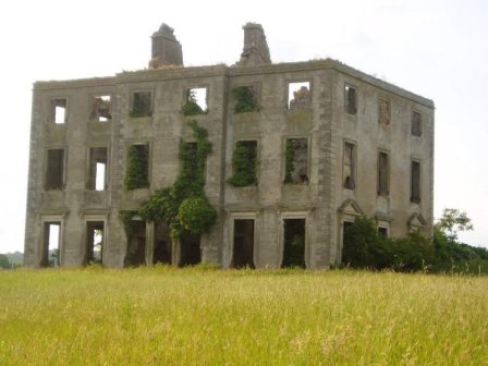
| Ballynagarde | The seat of the Croker family from early in the 18th century. Bence Jones writes that the house was built in 1774 and that it became a ruin during the 20th century. It was valued at £70 in the mid 19th century and held in fee by John Croker. The seat of H.S. Croker in 1894. By 1906 this house was valued at £119+ and was occupied by Courtenay Croker. The Irish Tourist Association Survey records the occupation of this house by the Defence Forces in 1942. It is now a ruin. |

|
| Caherelly Castle/Coole House | Lewis refers to Mrs Furnell’s residence as "a neat building in the cottage style" situated near Longford bridge. The substantial house marked at this location on the first Ordnance Survey map is named Caherelly Castle but on later maps is recorded as Coole House. The Ordnance Survey Field Name Book call it Cahir Elly Castle or Coole House. It was valued at £30 and occupied by Michael Furnell who held it in fee at the time of Griffith's Valuation. This house may have been known as Caherelly Grange in the last decades of the 19th century (see ''Burke's Irish Family Records''). The house is no longer extant but the outbuildings still remain. | |
| Caherelly Cottage/Caherelly Castle | A plaque records the building of this house in 1800 by William Hannan. Lewis refers to the residence of Mr Hannan in well planted grounds. The Ordnance Field Name Book refers to Cahir Elly Cottage as the residence of William Hannan. Marked as Caherelly Cottage on the first Ordnance Survey map, this house was located close to the ruins of an old castle and is now known as Caherelly Castle. Valued at £12 in the early 1850s and occupied by Michael Furnell who held it in fee. It later became the home of Michael Furnell's brother Frederick, an army surgeon. David O'Shaughnessy's interest in this house was advertised for sale in October 1853. |

|
| Edwardstown | Edwardstown was the residence of John Russell in the early 1850s held by him in fee and the buildings were valued at £18+. |

|
| Glen View | John Russell was the occupier of a house at Glen at the time of Griffith's Valuation. He held the property from Miss Abigail Briscoe and the buildings were valued at £15+. Slater also recorded Glenview as the seat of John Russell in 1894. This house is now demolished. |

|
| Williamstown Castle | Lewis refers to Williamstown Castle having been restored by the Messrs Pain, architects. In the early 1850s John Croker is recorded as the occupier, holding the property in fee. The buildings were valued at £33. It is now a ruin. | |
| Rockstown House | A building valued at £18 at the time of Griffith's Valuation, occupied by Chartres Brew Maloney and held from James Kelly. Chartres Brew Molony, second son of Patrick Molony of Cragg married his cousin Alice, daughter of James Barry of Rockstown, in 1841.Rockstown Castle was inherited by James Kelly's grandson, Basil James Kelly, in the 20th century and was left by him to his nephew Derrick Morley in 1945. It is still extant |

|
| Sandville | The home of the Barry family in the 18th and 19th centuries, the house became known as Sandville in the early 19th century. The Ordnance Survey Name Book dates the building 1799. John Barry occupied this house on the Kelly estate at the time of Griffith's Valuation when the buildings were valued at £26. John Grene Barry was resident in the 1870s and 1880s. Buildings are still extant at the site. | |
| Ballymacreese | A residence of the Greene family in the 18th century and noted by Wilson as the seat of Mr. Greene in 1786. The Ordnance Survey Name Books refer to this house as the seat of Mr James Shine, rebuilt in 1829 at a cost of £900. Occupied by James Shine in the early 1850s and held from the representatives of Frederick Lloyd. The buildings were valued at £26. Jeremiah Shine of Ballymacreese owned 79 acres in the county in the 1870s. The house is still extant and well-maintained. |

|
| Rockview | A 2 storey house on the Croker estate, built in 1837 for £400, it was occupied by George Peacock circa 1840 and in the early 1850s when it was valued at almost £12. There is still an extant house at the site. |

|