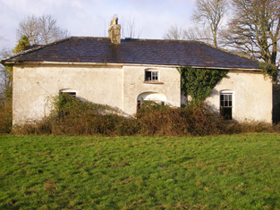
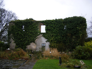
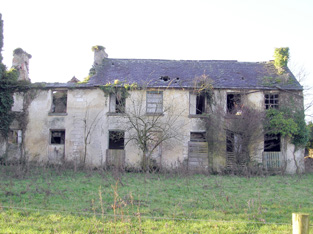
Eyon
Houses within 5km of this house
Displaying 15 houses.
Houses within 5km of Eyon
Displaying 15 houses.
| House name | Description | |
|---|---|---|
| Ballyvorheen | Occupied by Edmond Bourke in 1814, by T. Holland in 1837 and William F. Holland at the time of Griffith's Valuation who held the property from Thomas Lloyd. The buildings were valued at £25. | |
| Linfield | This house was the residence of Darby O'Grady in 1837 and the early 1850s. He held it from the Lloyd Apjohn family who subsequently lived in it. Sold by the Lloyd Apjohns following the death of Michael Marshall Lloyd Apjohn in 1895. This house was a ruin until recently renovated and is now inhabited. |

|
| Portnard | Located on the Stafford O'Brien estate and occupied by the Reverend Rickard Lloyd in the mid 19th century, when the buildings were valued at £27. Miss Catherine Lloyd was the last Lloyd occupant. The property was sold 1910-1913. |
|
| Towerhill | This property was the original residence of the Lloyd family where they settled in the 17th century. It passed to William, second son of Reverend Thomas Lloyd of Towerhill. Occupied by William's son, Reverend Rickard Lloyd, in 1814. The buildings were valued at £31 at the time of Griffith's Valuation when William Lloyd was the occupier. The property was held from the Stafford O'Briens. Purchased by the Devanes at the end of the 19th century, the house is now in ruins. |
|
| Abington House | Abington House in the townland of Dromeliagh is marked on the first Ordnance Survey map. In 1786 Wilson states "at Abingdon, is a very pleasant seat of Sir Nicholas Lawless". At the time of Griffith's Valuation a house valued at £17 was occupied by Michael Apjohn in this townland. In the 1860s this house was occupied by John Connell Fitzgerald and his wife Margaret (Apjohn). ''The Limerick Chronicle'' of 1 Oct 1872 records the death of Mary Anne Apjohn of Abington House, widow of Michael Apjohn. The property was held from Lord Cloncurry. A ruined house is still extant at the site. |
|
| Farnane House | Located on the Cloncurry estate Farnane was the home of the Costelloe family from at least 1837. Occupied by Thomas Costelloe in the early 1850s and valued at £12+. It is labelled Farnane House on the 1st edition Ordnance Survey map but is not labelled on the later 25-inch edition of the 1890s. It is no longer extant. | |
| Wilton | In 1786 Wilson refers to Wilton-Hall as the seat of Mr. Perceval. A house labelled Wilton is shown on the 1st edition Ordnance Survey map. It was occupied by George Duhy at the time of Griffith's Valuation, valued at £14 and held from Lord Cloncurry. On the 25-inch map of the 1890s this property is labelled Wilton Constabulary Barracks. It is no longer extant. | |
| Ballyvorneen | This house is marked on the first edition Ordnance Survey map at the site of a castle. Described as a "dairyman's house" at the time of Griffith's Valuation and held by William and Thomas Gabbett, younger brothers of Joseph Gabbett of High Park, in fee. The buildings were valued at £15. The house no longer exists. |

|
| Boskill | Lewis records B. Friend residing at Baskill in 1837. The Ordnance Survey Field Name Book records two houses. Boskill House the original residence of the Frends dating back to the 17th century and located at the northern point of the townland. It was at the end of the 1830s a thatched house which had been converted into a stable. Boskill Lodge (marked on the first Ordnance Survey map as Boskill House) was built in 1800 by Captain Benjamin Frend, at a cost of about £600. At the time of Griffith's Valuation Benjamin Friend junior occupied this house which was valued at £18. In 1906 a mansion house in the townland of Templemichael valued at £30.15 shillings was the residence of Edith M. Minchin and Agnes E. Rose. The Frends and the Roses of Ardhu House were related. The Irish Tourist Association surveyor in 1942 records the burning of this house in the Civil War and that there was "no trace of the house now". | |
| Lombardstown | The Ordnance Survey Field Name Book states that this house was rebuilt in 1823 by the occupier Thomas O'Brien. It was still occupied by Thomas O'Brien in the early 1850s. The buildings were valued at £11 and the property held from Lady Charlotte Wolfe. | |
| Maddyboy | Occupied by John Burke in 1814, by Captain Wickham in 1837 and by Benjamin Lucas in the early 1850s. The buildings were valued at £14 and the property held from John Lucas. | |
| Dromkeen | In the early 1850s John Hussey de Burgh lived in this house, situated near the old home of the Burgh family, also named Dromkeen. He held the property in fee. The buildings were valued at £19+. By 1906 Dromkeen was valued at £10. | |
| Dromkeen House | Fitzgerald refers to the old mansion of the Burghs as standing opposite the old walls of a church. Lewis refers to Dromkeen as "formerly the residence of the Burgh family" then occupied by the Reverend M. Lloyd, and that "the remains of the ancient mansion show it to have been an extensive and important establishment". A house at this site was occupied by Henry Croker at the time of Griffith's Valuation and valued at £34. It was held from Robert Smithwick. The Ordnance Survey Name Book refers to this house as William's Fort and states that it first belonged to the Burgh family and was rebuilt in 1820. Valued at £17 in 1906 and occupied by Digby H. De Burgh. |

|
| Mountsion | Occupied by Robert Bradshaw in 1814 and by Helenus White in the early 1850s. The buildings were valued at almost £9 and were held in fee. | |
| Landscape | The Reverend M. Lloyd Apjohn was the occupier of this house at the time of Griffith's Valuation. He held it in fee and it was valued at £21. The original house is not extant and a modern building has been constructed at the site in this century. |