Cahercorney
Houses within 5km of this house
Displaying 11 houses.
Houses within 5km of Cahercorney
Displaying 11 houses.
| House name | Description | |
|---|---|---|
| Loughgur Castle | In 1786 Wilson refers to Lough-Gur as the seat of Henry Baylee. This house was ccupied by John "Boylie" in 1814 and by Miss Bailie in 1837. In the early 1850s William Evans was resident. He held the house valued at £11 from the Count De Salis. It was adjacent to the remains of a tower house known as Bouchier's Castle. The property at this site is labelled "Lough Gur Farm" on the 25-inch map of the 1890s. The book edited by Mary Carbery, "The Farm by Lough Gur", published in 1937, contains a description of the Baylee property at Loughgur. The original Bayley house is no longer extant. | |
| Grange Hill | Leet records Grange-Hill as the residence of Edward Croker in 1814. Edward John Croker was resident at the time of the first Ordnance Survey. It was a residence of the Count De Salis at the time Griffith's Valuation. The Count held it in fee and the buildings were valued at £27. The Count was still the occupier of Grange in 1906. Owned by Colonel and Mrs Galloway in 1942. The house is now known as Loughgur. |
|
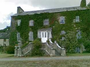
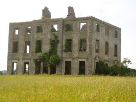
| The Grange | The home of the Grady/O'Grady family in the 18th and 19th century. In 1786 Wilson describes it as "the beautiful and well-improved seat of Standish O'Grady". It was inherited by the Crokers in 1861. Occupied by Standish [O'] Grady in 1814 and Henry O'Grady in 1837 and at the time of Griffith's Valuation. The buildings were valued at £77 and the property was held in fee. In 1894 it was noted by Slater as the seat of Captain Edward Croker. This house was described as in very good repair even though it had not been occupied for a number of years preceding the Irish Tourist Association survey of 1942. The house is now a ruin. |
|
| Rawleystown Court | Lewis writes that "in the parish of Cahercorney are the remains of Raleighstown, an ancient building erected by the uncle of Sir Walter and afterwards the property of the Croker family, who built a splendid house here, now in ruins". The Ordnance Survey Name Book states that the house was built about 75 years previously by the Crokers and that it was afterwards sold to one of the workmen employed in building it who immediately destroyed it. In 1786 Wilson refers to "Rawlen's-town/Rawleigh's-town" as a seat of the Croker family. The first Ordnance Survey map marks the house as a ruin. | |
| Mountminnett | Mountminnett was the location of the Minnitt family at the end of the 17th century. This house was the home of a branch of the Gabbett family in the first half of the 19th century. It was occupied by William Gabbett in the early 1850s when the buildings were valued at £11 and the Gabbetts held the property from Sir Richard Bourke. William Gabbett of Mountminnett owned 397 acres in county Limerick in the 1870s. | |
| Caherline | [The seat of the Gabbett family in the 18th and early 19th centuries]. Lewis refers to its occupation by a farmer and Griffith's Valuation records Thomas Barry as resident in the early 1850s when the buildings were valued at £16. The original house is still extant though with some modifications. It is now the home of the O'Grady family. | |
| Caherelly Castle/Coole House | Lewis refers to Mrs Furnell’s residence as "a neat building in the cottage style" situated near Longford bridge. The substantial house marked at this location on the first Ordnance Survey map is named Caherelly Castle but on later maps is recorded as Coole House. The Ordnance Survey Field Name Book call it Cahir Elly Castle or Coole House. It was valued at £30 and occupied by Michael Furnell who held it in fee at the time of Griffith's Valuation. This house may have been known as Caherelly Grange in the last decades of the 19th century (see ''Burke's Irish Family Records''). The house is no longer extant but the outbuildings still remain. | |
| Caherelly Cottage/Caherelly Castle | A plaque records the building of this house in 1800 by William Hannan. Lewis refers to the residence of Mr Hannan in well planted grounds. The Ordnance Field Name Book refers to Cahir Elly Cottage as the residence of William Hannan. Marked as Caherelly Cottage on the first Ordnance Survey map, this house was located close to the ruins of an old castle and is now known as Caherelly Castle. Valued at £12 in the early 1850s and occupied by Michael Furnell who held it in fee. It later became the home of Michael Furnell's brother Frederick, an army surgeon. David O'Shaughnessy's interest in this house was advertised for sale in October 1853. |

|
| Friarstown (Grange) | At the time of Griffith's Valuation this house was held from James Kelly by James H. Barry, the buildings were valued at £12. In 1906 Bazil R. Kelly held about 400 acres of untenanted land and buildings valued at £12 at Friarstown. This house is still extant. |

|
| Ballynamona | A small property known as Quarryfield Cottage occupied this site at the time of the First Ordnance Survey. The property here was the home of George Vandeleur in the 1870s. On the later 25-inch map of the 1890s a much larger property, labelled Ballynamona House, is shown. A house is still extant at the site. | |
| Ballybrood | A house in the village of Ballybrood, the residence of a branch of the Maunsell family in the 18th and early 19th centuries. Occupied by Samuel Maunsell at the time of Griffith's Valuation and held by him in fee. The buildings were valued at £11+. |