Bunratty Castle
Houses within 5km of this house
Displaying 18 houses.
Houses within 5km of Bunratty Castle
Displaying 18 houses.
| House name | Description | |
|---|---|---|
| Ballintlea | Weir writes that the original house dates from 1696. Ballintlea was occupied by John Kelly in 1837, who is recorded as holding the property in fee at the time of Griffith's Valuation. The Kellys appear to have bought Ballintlea from the D'Esterres. The Kelly and Kelly Roche families have resided there ever since. Fitzjames Kelly was in possession in 1906. | |
| Ballycunneen | Hogan writes that this house was built in 1805 by Thady, son of Thady O'Halloran the diarist, in front of the old Hickey house. Marked on the first Ordnance Survey map this house was occupied by Stephen O'Halloran who held the property from Colonel George Wyndham. It was valued at £15 and had 159 acre demesne. The house is still extant. | |
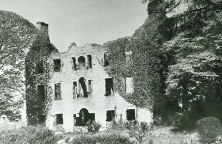
| Firgrove | Hogan writes that the building of Firgrove was begun by Thomas, son of Thady O'Halloran, the diarist, and completed by John MacMahon of Knockane. John Peter Kelly took over the house from MacMahon. In 1851 Eliza, daughter of John Scott of Firgrove, married George Fosbery of Clorane, county Limerick. The house was occupied by Charles Butler in the mid 19th century who held the property from John Kelly. It was valued at £35. The house was demolished in the 1920s. |

|
| Deerpark | Home of the Daltons for much of the 18th century. Occupied by Simon O'Donnell in 1814 and by Edward Maunsell (son of George of the Ballywilliam, county Limerick family) in 1837 and at the time of Griffith's Valuation, when it was valued at £30. Maunsell held the property from Matthew Canny. Inherited by Maunsell's fifth son Thomas. It was sold to Shannon Development in the 20th century. | |
| Rossmanagher House | A D'Esterre home, occupied by Lieutenant Colonel William O'Brien in 1837 and by Solomon Frost in the mid 19th century, when it was valued at £7. Historians and archaeologists believe that this building, some of which still survives, dates to the sixeenth or seventeenth century. | |
| Rossmanagher Cottage | The house in the townland of Newpark is named Rossmanagher Cottage on the first Ordnance Survey map. This was another D'Esterre home, occupied by Richard K. D'Esterre at the time of Griffith's Valuation, valued at £10 and held from Caleb Powell. The remains of a building are still extant at the site. | |
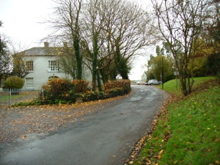
| Springfield | Weir writes that the Morice family probably built this house which was located on the Wood estate. It is recorded as the residence of Henry Wilson in 1814 and of F. Morice in 1837. Griffith's Valuation records that Francis Morice held the property from George A. Wood in the mid 19th century. The house was valued at £28. This house which was renovated is still inhabited. | |
| Bunratty | Built in 1804 for Thomas Studdert, it was a Studdert home throughout the 19th century and for part of the 20th century. The house was used by Shannon Development as their offices for some time and it is now part of the Bunratty Folk Park. | |
| Bunratty Lodge | Originally a Spaight home, inhabited by Richard Dawson and his wife Ellen Studdert. Richard Dawson was the third son of Charles Dawson of Charlesfort, county Wexford and left an only son also named Richard who lived in this house at the time of Griffith's Valuation, holding it from Thomas Studdert. In 1837 Lewis wrote that this house immediately adjoined the village of Bunratty and was the residence of Mrs Paliser. | |
| Clonmoney West | An early 18th century house, built and owned by the Westropps until the 20th century. The O'Donnells were resident at the end of the 18th century. It was leased to Henry White in 1814 and to D. Canny in 1837. Matthew Canny held Clonmoney from John Westropp in the mid 19th century, when the property was valued at £25. The Cannys subleased the property to Michael Macnamara. The executors of Macnamara's will advertised the sale of his interest in Clonmoney in January 1880. The original house is not extant now. |

|
| Woodpark | Weir records the marriage of Michael Dalton and Mary Anne Fitzgerald of Castlekeale in 1761. Woodpark was the residence of M. D'Alton in 1837 and of John Kennedy in the mid 1850s. The house was in ruins in the early 20th century. |
|
| Ballycaseymore | An 18th century house close to the entrance to Shannon Airport, it was the home of the Miller/Riggs Miller family. From 1814 it appears to have been leased to the Canny family, John Canny was in residence then and Matthew Canny at the time of Griffith's Valuation. The property was inherited by Thomas John Ryan of Tyrone House, county Tipperary in the 1880s and was sold in 1913. It is now a craft and design centre. |
|
| Bunkers Hill | A mid 19th century house, the home of James Forost (1827-1907), author of ''The History and Topography of the County of Clare'' (1893), who held the house and 139 acres from Lord George Quin. He was the eldest son of William Frost and his wife Mary Ryan and he married Bedelia daughter of Augustine Moran of Willbrook. He left the house to the Dundon family who sold it to the Ryans circa 1917. Members of the Ryan family still live at Bunkers Hill. | |
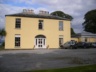
| Cartown | Built in 1763 Cartown was the residence of Mr Baldwin in 1826 and of John Edward Langford in 1837. In the early 1850s Griffith's Valuation records the vacant house as valued at £24, William Sheedy holding the whole townland from General James Caulfeild. By the late 19th century the house was in the possession of the Westropp family. This house is still extant and occupied. |
|
| Mellon | The Westropp family are recorded as "of Mellon" from the early 18th century. Bence Jones dates the present house from circa 1780, the Ordnance Survey Field Name Books from 1812. Inhabited by Mrs Jane Westropp (nee Dawson) in the early 1850s. It was valued at £36. This 3 storied house was still in Westropp possession in the late 20th century. It is now run as a stud. |
|
| Mount Pleasant | The Ordnance Survey Name Books record that this house was built in the mid 18th century by a Mr Star. It was a neat farm house occupied by Mrs Hill in 1837 and by Thomas Hill at the time of Griffith's Valuation. He held the property from Daniel Leahy and the buildings were valued at over £11. This house is still extant and occupied. |
|
| Ballynacarriga | The Ordnance Survey Field Name Books describe this house as "falling into decay", the property of Mr Enright. By 1837 a Mr Dawson was the proprietor of Ballynacarriga House and in the early 1850s it was occupied by Dawson L. Westropp. In 1906 Ballynacarriga valued at £20.10 shillings was occupied by Norris Richard Russell. | |
| Brickhill | The home of the Maghlin family in the early 18th century, it passed by marriage to the Blood family. Occupied by the Lysaght family in the mid 18th century. Edward Lysaght, songwriter and lawyer, known as 'Pleasant Ned' was born at Brickhill in 1763. The house is not named on the first Ordnance Survey map and a 20th century house now occupies the site. [Grid reference is approximate]. |