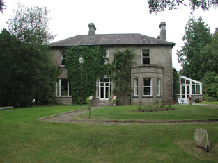
Toberpatrick
Houses within 10km of this house
Displaying 36 houses.
Houses within 10km of Toberpatrick
Displaying 36 houses.
| House name | Description | |
|---|---|---|
| Gillstown | The residence of Mr John Stafford in 1749 and of J. Hogg in 1837. Occupied by Thomas Cox in the second half of the 19th century, who held the property from John Blakeney. Valued at £5 in the 1850s. In 1906 the buildings at Gillstown were valued at £8.10s and were occupied by the representatives of Thomas Cox. | |
| Ballycummin | A house valued at £8 when occupied by Roderick J. Hanley, who held it from Laurence Murray, at the time of Griffith's Valuation. Described by Lewis in 1837 as the former seat of the Earl of Roscommon and at that time occupied by Lieutenant Rodrick J. Hanly. | |
| Fortview | At the time of Griffith's Valuation occupied by Erasmus Lloyd who held it from William Lloyd. This house is labelled Fortview on the 25-inch edition map of the 1890s. A house is still extant at the site. | |
| Ashfort House | The home of John Lawder in 1814. Occupied by Hubert K. Waldron in 1837. At the time of Griffith's Valuation occupied by John Hamilton and held from Thomas Goff. Farm buildings exist at the site now. There was a second smaller house known as Ashfort Vale in the same demesne grounds. It is no longer extant. | |
| Tully Lodge | Built circa 1820, occupied by J. W. Kelly in 1837 and by Christopher Lawder in the 1850s who held the property in fee. It was valued at £20. Occupied by Samuel Russell in 1906. Another house marked as Lakeview was in the demesne grounds at the time of the first Ordnance Survey. In 1837 W. McDonnell was residing in Lakeview [M987 921] |
|
| Sallyfield | A Hanly home from at least 1749 but by the 1850s held by George Lawder in fee. It was described at this time as a steward's house with offices and a lodge, valued at £3. It is labelled on both the 1st and 25-inch edition Ordnance Survey Maps as Sallyfield. It is no longer extant. A house named Cottage was also in the townland of Lavagh at N005 895 on both maps. | |
| Mount Dillon | Lewis writes that the house was situated on an isolated hill and formed "a conspicuous object in the surrounding scenery". Valued at £15 in the mid 19th century. Wilson, in 1786, refers to it as the seat of Mr. Dillon. In the possession of Samuel Russell in 1906 when the buildings were valued at £3. It is no longer extant. | |
| Smith Hill | Smithhill was in the demesne of The Palace at Elphin. It was the residence of the Reverend Oliver Jones, grandfather of Oliver Goldsmith, in the early 18th century. It was the home of Robert Jones Lloyd in the late 18th and early 19th century and of the Reverend John Lloyd in 1837. The house was unoccupied at the time of Griffith's Valuation when it was valued at £8 and held by Robert Lynch. The Ordnance Survey Field Name Books record that Goldsmith's father was born at Ardnagowna [or possibly Oliver himself, see http://en.wikipedia.org/wiki/Smith_Hill_(house)]. |
|
| Rooaun Lodge | At the time of Griffith's Valuation occupied by John Morton and held by him in fee, valued at £3. A house at Rooaun valued at £18 was occupied by T.A.F. O'Flaherty in 1906. | |
| Rockville | Home of the Lloyd family in the 18th and 19th centuries. Valued at £45 in the 1850s. Sold in 1917 to George Frayne of Ballaghderreen. Demolished in the second half of the 20th century. |

|
| Rush Hill | Home of the Devenish family in the 18th and 19th centuries, held from Sir Gilbert King. Funding received from the Heritage Council in 2005 for the restoration of this house. http://www.iol.ie/~oldbuilders/oldbuilders/rushhill/rushhill_01.htm. A detailed history and account of ongoing improvements to Rush Hill can be found at the blog www.irishaesthete.com tagged as Rush Hill. |
|
| Mount Pleasant | The residence of John Devenish in the mid 19th century. In 1894 Slater noted it as the seat of Michael Murray. It does not appear to be extant. On the first Ordnance Survey map another house known as Riverdale is also located at M907 775 within the Mount Pleasant demesne. Buildings are still present at this site. | |
| Lissadorn | Lissadorn was a Crofton home from the mid 17th century. It became a Lloyd home in the 18th century following the marriage of Catherine Crofton and John Yeadon Lloyd in 1786. By 1814 Joseph Healy was living at Lisadurn. Burke's ''Landed Gentry of Ireland'' (1904) records the second son of Walter Balfe of Heathfield as John Balfe of Lissadorn. J. Balfe was residing at Lissadorn in 1837. At the time of Griffith's Valuation, Bernard Balfe held Lissadorn, valued at £20, from Viscount Lorton. It is no longer extant. On the first Ordnance Survey map (1838) the demesne included a smaller house named Ryefield. |
|
| Cloonfree | The residence of William Mahon. Apparently the residence of George Knox in the 1840s. http://www.ballykilcline.com/story_f.html | |
| Cloonahee | Residence of Gilbert Conry in 1814 and of John Conroy esq in 1822. According to a note with the sale rental of 1853 the house was accidently burnt and a good farm house built as a replacement. The home of John Heague in the mid 19th century. Occupied by Richard Hague and valued at £40 in 1906. |
|
| Castlenode House | Residence of Thomas Morton esq in 1822 and of J. Morton in 1837. In the mid 1850s, George Walpole was the occupant of this house, which he held from the Pakenham Mahon estate when it was valued at £8. A house still occupies the site of the original Castlenode House. | |
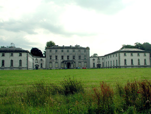
| Strokestown House | Late 17th century house altered in the early 19th century and home of the Mahon family for three centuries. In 1786 Wilson described it as "fine mansion house with ample and beautiful demesne". Referred to as "Bawn House", the mansion of Lord Hartland, by Lewis in 1837. Valued at £70 in the mid 19th century. Now a major tourist attraction containing the Famine Museum. http://www.strokestownpark.ie/ |
|
| Newtown Glebe | Newtown Lodge was occupied by Anthony Dignam in 1814 and the Glebe House at Newtown, valued at £18, was occupied by Reverend Joseph Morton at the time of Griffith's Valuation. It was leased from the Pakenham-Mahon estate. It is still extant. | |
| Cloonfinlough Lodge | Occupied by Robert Devenish at the time of Griffith's Valuation, who held the property from John Caulfeild. Buildings are still extant at the site. | |
| Foxborough | In 1786 Wilson refers to Foxborough as the seat of Arthur French. Occupied by Patrick Taaffe at the time of Griffith's Valuation, who was leasing from Christopher French. The house was then valued at £20. It is now a ruin though the stable yard survives. | |
| Ardkeenagh House | Michael Plunkett was farming at Ardkeenagh in 1749. In 1814 it was the home of Nicholas Peyton and of Mrs Hawkes in 1837. At the time of Griffith's Valuation the house was vacant but the surrounding lands were held by Patrick Moran from James Somerville. Buildings are still extant at the site. | |
| Bloomfield | In the possession of John Farrell in 1814 and of H. O'Farrell medical doctor in 1837. In the mid 19th century held by the Reverend Peter Toler in fee and valued at £10. Toler appears to have purchased Bloomfield from the sale of the Cargins Park estate by the trustees of Daniel Kelly. | |
| Cloonmurray | Leased by Marcella Dillon to the Reverend Michael Lennon at the time of Griffith's Valuation and valued at £9. Some ruins remain at the site. | |
| Mount Browne | At the time of Griffith's Valuation occupied by George Browne who held the property from James G.Plunkett, valued at £25. The sale rental of the Gunning Plunkett estate in June 1857 states that Mount Browne was held by a fee farm grant from Jane Plunkett, mother and guardian of the owner, to George Browne, dated 30 Oct 1852. Occupied by the representatives of Arthur Browne in 1894 and 1906. | |
| Creta | Occupied by George Harken in 1814 and Daniel Hughes in the mid 1850s and valued at £8. Creta Cottage was occupied by Captain Dillon in 1837. A house is still extant at the site. | |
| Cherryfield | Home of the Mills family in 1778. Noted by Wilson as "the fine seat of Oliver Mills" in 1786. Lewis refers to it as a seat of the same family in 1837. It was occupied by Michael Butler in the 1850s and held from John Carroll, valued at £10. It came into the ownership of the McGreavy family in the latter part of the nineteenth century and remained in their possession until the 1960s. It is now derelict. | |
| Moss Hill | Occupied by Peter Conry in 1814 and by Captain Conry in 1837. | |
| Lisroyne Lodge | A house on the outskirts of Strokestown, part of the Strokestown House demesne, valued at £10 at the time of Griffith's Valuation and occupied by Michael Flynn. Some buildings are still extant at the site. | |
| The Palace | Built as the residence of the Protestant Bishop of Elphin in 1685 from money bequeathed by Bishop Hudson. Altered in the mid 18th century and remained as the Bishop's residence until 1845. At the time of Griffith's Valuation the home of Arthur O'Conor, younger brother of Denis O'Conor of Mount Druid. Valued then at £55 and held from the Ecclesiastical Commissioners. Accidentally burnt in 1911, the main block is now demolished. | |
| Lisnanuran | Occupied by Robert Burns at the time of Griffith's Valuation and held from Arthur F. Lloyd. | |
| Kinard | Possibly a Plunkett house at the end of the 18th century. At the time of Griffith's Valuation John Clarke occupied the house which he held from James Somerville, valued at £5. It is labelled Kinard House on both the 1st and 25-inch edition Ordnance Survey maps. A house is still extant at the site. | |
| Lisnaneane | Gormley states that the widow of Dominick O'Conor Don lived at Lisnanean after Dominick's death in 1795. Later it was the home of Malachy Madden in 1814 and of Catherine O'Conor Don's nephew Robert Nolan and his family in the 1830s. No demesne is marked on the first Ordnance Survey map. At the time of Griffith's Valuation the house was valued at £5 and was held by Robert Nolan in fee. A house still exists at the site. | |
| Rossmore | Rossmore East was part of the estate of James Murphy at the time of Griffith's Valuation. The house was built circa 1860s (Buildings of Ireland). However the Ordnance Survey Field Name Books record a house and large gardens in the 1830s. |
|
| Cloonagh Lodge | An extensive complex of mills is shown at this location on the 1st edition Ordnance Survey map of 1840, including two flour mills. At the time of Griffith's Valuation, Matthias McDonnell was leasing mill properties, valued at £67, from the estate of the Marquis of Sligo. In addition he was leasing a house valued at £4. Cloonagh Lodge is shown on the 25-inch Ordnance Survey map of the 1890s. A house is still extant at the site. . | |
| Ballyoughter | Occupied by John Goldsmith at the time of Griffith's Valuation. He held the house valued at £8 and 60 acres from Marcus McCausland. Another John Goldsmith was residing in Ballyoughter a hundred years earlier at the time of the Elphin Census. Wilson also refers to the house as the seat of Mr. Goldsmith in 1786. A later house, also named Ballyoughter House, is shown on the 25-inch Ordnance Survey map of the 1890s and there is still a house at this site, | |
| Curraghroe | At the time of Griffith's Valuation this property was in use as a Constabulary Barracks, valued at £5 and leased from the estate of Theobald Dillon. Local sources suggest the police were withdrawn from the barracks in the late 1860s. In modern times it has become known as Sullivan's Cross. The house is still extant and occupied and in 2014 was offered for sale. |