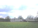
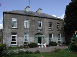
Runnamoat
Houses within 10km of this house
Displaying 47 houses.
Houses within 10km of Runnamoat
Displaying 47 houses.
| House name | Description | |
|---|---|---|
| Durrow | In 1786 Wilson refers to "Durra" as a seat of Mr. Bagot. At the time of Griffith's Valuation, Francis Hurley was leasing a property valued at £7 together with over 100 acres, from the Bagot estate at Durrow, barony of Ballymoe. A house is still extant at the site. |
|
| Clooncah | A house built after the publication of the 1st Ordnance Survey map, at the time of Griffith's Valuation it was by John Love. The house was valued at £12 and held from John Armstrong. In 1885 Walford describes John Armstrong as a magistrate for county Galway, and of "Clooncagh and South Hill, Clifden". The site at Clooncah is now occupied by farm buildings. | |
| Glinsk House | In 1786 Wilson refers to Glinsk as the "seat of the late Sir John Burke" and also as the seat of Sir Rickby Burke. Glinsk Castle and a substanial house are both marked on the 1838 Ordnance Survey map. The castle is shown on the 25-inch map of the 1890s but there is no trace of the house. At the time of Griffith's Valuation, Allen Pollok held buildings valued at £1 15 at the site, recorded as a herd's house. | |
| Dunamon | A tower house with 18th and 19th century additions, In 1786 Wilson refers to Dunamon, the seat of Mr. Caulfeild, as "a fine old castle". Occupied by John Shiel, leasing from the Caulfeild estate at the time of Griffith's Valution, when it was valued at £35. In 1894 Slater refers to it as a residence of St.Geroge Francis Caulfeild. Bought by the Divine Word Missionaries from the Land Commission in 1939 and now in use as a care centre. |
|
| Castlecoote | An 18th century house which has recently been restored. Occupied by T. and J. Nolan in 1814 and by William John McLoughlin in the 1850s, when the house was valued at £40. In 1894 it was the seat of Arthur and Francis Chute. See www.castlecootehouse.com. |
|
| Emlaghkeadew | At the time of Griffith's Valuation this house was ccupied by Louis Ormsby when it was valued at almost £10. It is no longer extant and a modern house exists at the site now. | |
| Coolmeen | Referred to as a herd' s house at the time of Griffith's Valuation when it was occupied by William Harrison who held it from Patrick Curtis. The house now extant at the site is not the original one. |
|
| Mount Prospect | This house was the residence of John Browne in 1814. Recorded as the seat of Mr Fallon at the time of the first Ordnance Survey in the 1830s but in ruins by the mid 1850s. though a small portion of the house is labelled Mount Prospect on the 25-inch Ordnance Survey map of the 1890s. Small fragments of the building remain at the site. | |
| Fortwilliam (Castlereagh) | The estate of William W.R. Sandford was leasing the house at Ballyfinegan, barony of Castlereagh, to Patrick Tighe at the time of Griffith's Valuation when it was valued at £11. Lewis records a house called Fortwilliam in the parish of Ballintober as the seat of P. Teighe in 1837. The Census of Elphin recorded William Compton as resident at Ballyfinegan in 1749. There is still an extant house at the site. | |
| Frenchlawn | At the time of Griffith's Valuation, the estate of William W.R. Sandford was leasing a property valued at £12 at Frenchlawn, barony of Castlereagh, to James Glancey. In 1837 Lewis recorded Frenchlawn as the seat of Mrs. French. In 1814 it was the residence of Christopher French. There is still an occupied house at this site. |
|
| Willsgrove | William W.R. Sandford's estate was the lessor of two properties at Willsgrove, barony of Castlereagh, at the time of Griffith's Valuation. One, valued at £10, was vacant while the second was leased to Anne Glancey together with 260 acres. In 1837 Lewis records Willsgrove as the seat of W.R. Wills. In 1786, Wilson refers to Willsgrove as the seat of Thomas Wills, "a large and fine house". The 1749 Census of Elphin records that Godfrey Wills was resident at Willsgrove. In 1783 Taylor and Skinner note Willsgrove as a seat of the Wills family. It is described as "in ruins" on the 25-inch Ordnance Survey map of the 1890s. | |
| Bohagh Lodge | At the time of Griffith's Valuation, Robert Glancey was leasing a house valued at £6 and over 500 acres at Bohagh, barony of Castlereagh from Travers R. Blackley. | |
| Cleaboy House | Patrick Balfe was leasing a property valued at £10 from Teresa Madden at Cleaboy, barony of Castlereagh, at the time of Griffith's Valuation. A house is still extant at the site. | |
| Ballaghawbeg | Richard Irwin's estate owned a herd's house valued at £2 together with over 400 acres at Ballaghawbeg, barony of Castlereagh, at the time of Griffith's Valuation. The Census of Elphin in 1749 recorded that Charles O'Conor, farmer, held this property at the time. Some ruins exist at the site. | |
| Emlagh | Robert Irwin was leasing a property valued at £5 + 230 acres at Emlagh, barony of Castlerea, to Patrick Flynn, at the time of Griffith's Valuation. The Census of Elphin indicates that John Irwin resided there in 1749. Gormley states that the house was probably built around 1740 and extended in the early 1800s. By the 1880s the Irwins had sold Emlagh to Walter McDermott. The house was later demolished. | |
| Milltown | Roderick O'Conor/O'Connor occupied the property at Milltown, barony of Castlerea, valued at £36, at the time of Griffith's Valuation. It was also recorded as his seat in both 1814 and 1837. Gormley states that nothing of the house now remains save for traces of the mile long avenue. | |
| Heathfield | Patrick Balfe was leasing the property at Heathfield, valued at £36, to John Butler at the time of Griffith's Valuation. Lewis records Heathfield as the seat of Nicholas Balfe. It was also his seat in 1814. Gormley states that this house was originally known as Belgard Lodge and was part of the estate of Thomas Dillon of Belgard Castle, county Dublin. Richard Irwin of Fernhall acted as his agent in Roscommon. By 1830 the Heathfield estate was owned by Patrick Balfe and by the 1850s it was occupied by the Butler family, originally of Cherryfield, Elphin. They continued to occupy the house until the 1940s. The house is still extant. | |
| Cloverhill | Latouche esquire lived at Cloverhill in 1778 and Wilson refers to it as the seat of John La Touche in 1786. The residence of Thomas Hurst in 1814 and of John Hurst in 1837. Occupied by Edward Jones, who held from Thomas Booth, at the time of Griffith's Valuation. The main road has been directed through the site and only a few ruins remain. | |
| Laragh and Ross | The residence of Thomas Tighe in 1814. In 1830 held in fee by the Mahons of Cavetown. At the time of Griffith's Valuation occupied by Patrick Joseph O'Connor who held the house from Patrick O'Connor. Modern farm buildings occupy the site now. | |
| Fern Hall | At the time of the first Ordnance Survey the Trant family were recorded as the proprietors of the townland of Polranny, barony of Castlereagh, including Fern Hall House. Henry Dillon Trant was leasing it to John Irwin at the time of Griffith's Valuation when it was valued at almost £5. Gormley states that this branch of the Irwins was the oldest in the area, having been recorded there in the sixteenth century. The house was not in good repair by the end of the nineteenth century and no trace remains now. | |
| Brierfield | The Hawkes family built a chapel of ease at Brierfield in 1720. Brierfield was their main residence in the 18th and 19th centuries. Sold to Cox Cotton in the late 19th century, no longer extant. | |
| Tinny Park | Occupied by T.T. Byrne in 1837 and held in fee by Hugh Burns in the mid 1850s when it was valued at £11. It is still extant. It was offered for sale in 2016 and again in 2022. |
|
| Corrastoona More House | In 1749 Richard Kirwan was living at Coristoonamore. This house appears to have been the residence of K. Lyster [Kirwan Lyster?] in 1814 and of F.T. Byrne in 1837. Occupied by Patrick O'Connor in the mid 1850s, who held the house from Christopher Hamilton. Valued at £2 in 1906 and in the occupation of Sir N. O'Conor. It is no longer extant. | |
| Bopeep Lodge | A Blakeney property that was leased to H. French in the 1830s and to Robert French in the 1850s. |
|
| Dundermot | A Blakeney property, built circa 1750.Taylor and Skinner note is as occupied by Owens esquire in 1778. In 1786, Wilson refers to it as the seat of Samuel Owens Lee. It was the residence of Richard Kelly in 1814 and held by Patrick O'Connor at the time of Griffith's Valuation when the house was valued at £36. In the 1890s it became the home of the Blake-Kellys, although Nicholas O'Conor is recorded as the occupier in the valuation lists for 1906. Still extant and restored in the early 21st century. |
|
| Leabeg | Wilson refers to Leabeg as the seat of Mr. "Irvine" in 1786. The residence of Edward Irwin in 1814 and held by Daniel H. Irwin in fee at the time of Griffith's Valuation, when the house was valued at £6. It is described as "in ruins" on the 25-inch Ordnance Survey map of the 1890s. | |
| Ballymacurly | Andrew McDermott was farming at Ballymackeriley, parish of Cloonygormican in 1749. Occupied by Michael Nolan in 1837 and in the 1850s and held from Hugh O'Byrne. |
|
| Emlaghroyin | Built circa 1770, occupied by McDermot esquire in 1778 and also noted as the residence of Thomas McDermott by Wilson in 1786. The seat of Oliver Armstrong at the time of Griffith's Valuation, held from St George Caulfeild and valued at £30. This house is still extant. |
|
| Newtown | Originally an Irwin property, bought by the Brownes in the 18th century. Held by the Very Reverend Henry M. Browne at the time of Griffith's Valuation and occupied by Henry Farmer. | |
| Rushfield House | Occupied by Patrick Shiel at the time of Griffith's Valuation .Labelled Rushfield House on the 25-inch Ordnance Survey map of the 1890s. There is still a house at the site. | |
| Kilbegnet House | Occupied by John Shiel at the time of Griffith's Valuation and valued at £25. The property is labelled Kilbegnet House on the 25-inch edition of the Ordnance Survey map. A house is still extant at the site. | |
| Temp House | A house called Tempe was occupied by Charles O'Connor in 1814. IN the 1850s it was leased by Tobias Kelly from Catherine Mennons and valued at £13. A house is still extant at the site. | |
| Church Park | Church Park was occupied by Benjamin Reeves in 1814. It is shown on the First edition Ordnance Survey map of the 1840s but is not labelled on the later 25-inch edition of the 1890s. The house is no longer extant but entrance gates are still visible. | |
| Essex Lawn | Built after the First Ordnance Survey on part of the estate of the Earl of Essex, this house was occupied by John Kelly in the 1850s when it was valued at £18 10s. It is still extant. |
|
| Derrane House | The home of the Corr family in the 19th century, Henry Corr is recorded as living at "Durham" in 1814. Henry "Gorr" was residing in a property here valued at £12 at the time of Griffith's Valuation. It is recorded as "Derrane House [in ruins]" on the 25-inch Ordnance Survey map of the 1890s and very little trace remains of it now. | |
| Roxborough | Wilson, writing in 1786, refers to Roxborough as the seat of "Mr. Irvine". The residence of John Irwin in 1814 and of A. Brown in 1837. In the 1850s occupied by John Gaynor, when the house was valued at £20. The property is now a ruin. | |
| Mullymucks/Fortview | Built post 1838, though the National Inventory of Architectural Heritage suggests it is a modified 18th century house. Occupied by Francis Lyng in the 1850s, when it was valued at £24. It is still extant and now known as Fortview House. |
|
| Munsborough House | Built post 1838 and occupied by Edward Pearse in the 1850s, when it was valued at £20. Extensive buildings are shown at the site on the 25-inch edition Ordnance Survey map of the 1890s, labelled Munsborough House. A house and large farm are still extant at the site. | |
| Ballybride | James O'Farrell was leasing over 180 acre and a herd's house from Louisa Pelly at Ballybride, barony of Roscommon, at the time of Griffith's Valuation. | |
| Castleplunkett | Gormley states that the Plunketts built a mansion near Castleplunkett village sometime between 1655-1660. This building was later destroyed by fire in the mid-nineteenth century and the stones later used in building in the area. | |
| Toomona | The home of Michael Connor, a gentleman in 1749, just outside Tulsk. The residence of Michael's grandson Peter O'Connor in 1814 and 1837. At the time of Griffith's Valuation Toomona was valued at £10 and was occupied by Maria French who held it from Lord Crofton. Later occupants included Colonel Lynham, Matt Flanagan, the Murphy and Fallon families. Accidently burnt in the 1970s. | |
| Brook Lodge | The Ordnance Survey Name Books refer to Brook Lodge in the south of this townland. The house is labelled Brook Lodge on the 1st edition Ordnance Survey map but seems to have disappeared by the time the 25-inch edition was published in the 1890s. Modern buildings occupy the site now. | |
| Grange House | This house marked on the first Ordnance Survey map but not named would appear to have been the Ormsby's main residence in this townland. In 1786 Wilson refers to Grange as the seat of Gilbert Ormsby. It is labelled Grange House on the 25-inch Ordnance Survey map of the 1890s. The townland was part of the Farrell estate at the time of Griffith's Valuation. There is still a house extant at this site. | |
| Balydooley Lodge | John Hanley was leasing this property from St. George Caulfeild at the time of Griffith's Valuation, when it was valued at £5. It is still extant. | |
| Ardmore (Dunamon) | In 1786 Wilson refers to Ardmore as the seat of Mr. Croaghan. By the 1830s an extensive demesne is shown in the area but no house is visible. The townland is in the possession of St. George Caulfield of Dunamon by the time of Griffith's Valuation. | |
| Ashpark | In 1786 Wilson refers to Ashpark as the seat of Matthew Lyster. By the time of Griffith's Valuation this townland was in the possession of Christopher Hamilton and the most substantial house, valued at £4, was leased from his estate by Patrick Finner. Very little of the buildings are visible on the 25-inch Ordnance Survey map of the 1890s though farm buildings still exist at the site. | |
| Oran (Ballymoe) | In 1778 the residence of R. Malone esquire is recorded at Oran. Wilson also refers to this property as the seat of Lord Sunderlin [Richard Malone]. This residence may have been in the townland of Cartron, |