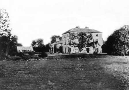
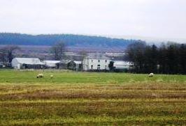
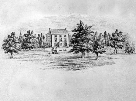
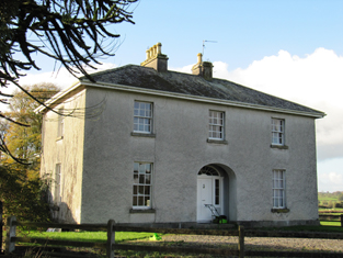
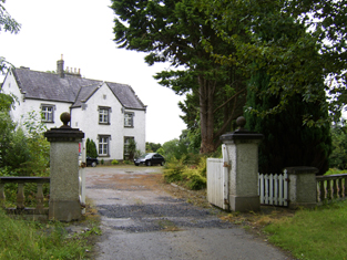
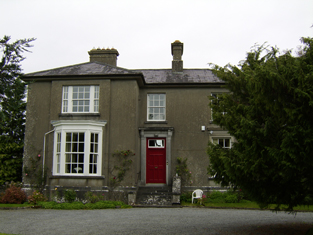
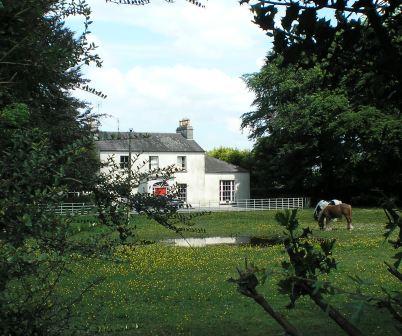
Coololla/Coololah
Houses within 10km of this house
Displaying 63 houses.
Houses within 10km of Coololla/Coololah
Displaying 63 houses.
| House name | Description | |
|---|---|---|
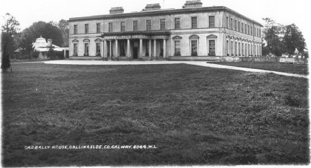
| Garbally Park | In 1783 Taylor and Skinner show Garbally as a seat of the Trench family. Wilson mentions Garbally , "the very fine seat of Willaim Power Keating Trench", in 1786. At the time of Griffith's Valuation it was the seat of the Earl of Clancarty and was valued at £150. It became St. Joseph's College, Garbally Park, in 1922 and has functioned as a school until very recently. It is still extant. |
|
| Somerset House | At the time of Griffith's Valuation, Thomas Stratford Eyre was leasing a house valued at £20 to William Seymour. Slater refers to the house as the residence of Thomas Craddock in 1894. In 1906 the property at Somerset was held by Charles Seymour. The original house is not extant but there are extensive remains of estate architecture. |
|
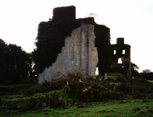
| Ballydonnellan Castle | At the time of Griffith's Valuation, Ballydonnellan Castle was occupied by John D. Mahon and was valued at £62. It was still extant in the 1890s but is described as "in ruins" on the 1933 edition of 6" map. These ruins are still visible. |
|
| Eastwell | In 1837 Lewis records Eastwell as the seat of C. Usher. At the time of Griffith's Valuation it was occupied by Christopher Usher and the buildings were valued at £79. By 1906 it was in the ownership of William A. Usher and was valued at £81. This house is no longer extant but extensive remains of stables, demesne and walled garden survive. |
|
| Ballyeighter | In 1814 Ballyeighter was the residence of Anthony Donnellan. Lewis records Balleighter as the seat of P. Donnellan. By 1855 it was being leased by Lord Clonbrock's estate to Martin Coolahan and was valued at £8. The Coolahans continued to own the property until the mid-20th century when it was divided by the Land Commission who also demolished the house. There is no trace of Ballyeighter now. | |
| Killagh | Lands at Killaghmore and Clonecallin amounting to 635 acres were granted to Edmond Donnellan in 1684. Wilson refers to it as the seat of Mr. Donnellan in 1786. Stephen Donnellan was occupying the property at Killagh, valued at £33, at the time of Griffith's Valuation. In 1906 it was in the possession of Stephen J.R. Donnellan. It is no longer extant. |

|
| Burkeville | Burkeville was offered for sale in the Encumbered estates court in July 1852. At the time, Maurice Bennett was the tenant of this "fine commodious dwelling house". At the time of Griffith's Valuation it was held by Nicholas Coolaghan and valued at almost £10. It was still in the possession of Nicholas Coolaghan in 1906. A house still exists at the site. | |
| Ballydonagh | Lewis records Ballydonagh as the seat of F. Madden in 1837. At the time of Griffith's Valuation the house was occupied by Francis Madden leasing from the Haughton estate and was valued at almost £4. Substantial ruins still remain at this site. | |
| Coolbeg House | In 1856 Thomas Stratford Eyre was leasing a property valued at £5 together with 146 acres, located in the townland of Coolbeg, parish of Clontuskert, barony of Longford to William Seymour. It is labelled Coolbeg House on the 25-inch Ordnance Survey map of the 1890s. A house still exists at the site. | |
| Crowsnest | In 1856 Allan Pollok was the occupier and lessor of a property valued at £6 together with over 460 acres, in the townland of Crowsnest, parish of Clontuskert, barony of Longford. Molloy provides a detailed description of the huge farmyard (M868239) in the neighbouring townland of Ganaveen which was part of the Pollok estate. The latter was destroyed by fire in 1920. The Crowsnest property is now in ruins. |

|
| Somerset Glebe | At the time of Griffith's Valuation William Seymour was leasing a property in the townland of Somerset, parish of Clontuskert, valued at £11 to Rev. Adolphus Drought. This property is now a ruin. | |
| Bettyville | At the time of Griffith's Valuation, a house at Cloonlahan, barony of Longford, valued at £5 together with over 300 acres was held by Michael McDermott. | |
| Killwood House/Gortnaraheen Glebe | In 1856, Thomas Stratford Eyre was leasing a property, described as a glebe house, in the townland of Gortnaraheen, valued at £8, to Rev. Thomas Grome. It has become known as Killwood House by the 1890s. A house still exists at the site. | |
| Mount Prospect (Kiltormer) | In 1856 Rev. David Seymour was leasing a house valued at £12 in the townland of Kiltormer East, barony of Longford, from Thomas Stratford Eyre. In 1837 Lewis mentions a residence of the Seymour family known as "Mount Pleasant" in this area. On the 25-inch Ordnance Survey map of the 1890s, however, this house is labelled Mount Prospect. It is no longer extant. | |
| Eyreville | A late 18th and early 19th century house built for the Eyre family. Lewis records Eyreville as the seat of T.S. Eyre in 1837. In 1856 Thomas Stratford Eyre was occupying a property valued at £36 in Newtowneyre, parish of Kiltormer, barony of Longford. in 1906 it was in the possession of the representatives of Thomas D. Eyre. In 2006 permission was being sought to carry out works on the site of Eyreville. While the house is no longer extant the remains of demesne buildings exist. |
|
| Fairfield House | Lewis records Fairfield as the residence of T. Wade in 1837. It is described in the Ordnance Survey Name books as "built on rising ground from which there is a good prospect". At the time of Griffith's Valuation the house was being leased by Thomas Wade from the Handy estate. In 1906 it was in the possession of Rochford Wade when it was valued at £23. Fairfield House is no longer extant and the demesne is the focus for a major sawmilling operation. |
|
| Oatfield | Oatfield House, owned by John Longworth , was vacant at the time of Griffith's Valuation. Earlier, in 1837, Lewis had recorded it as the seat of Major Lynch even though this house had been in the possession of the Longworth family since at least 1814. The Ordnance Survey Field name books also record it as the residence of Major Lynch. In 1783 Taylor & Skinner and in 1786,Wilson, both recorded Oatfield as a property of the Brabazon family. By 1906 it was the property of Edward Longworth. The original house is not extant at the site now. |
|
| Doon House | At the time of Griffith's Valuation Charles Filgate was leasing a house valued at £5 and 400 acres from the Clonbrock estate. In the 1830s, he is noted in the Ordnance Survey name books as the agent for several county Galway estates, including the Mahons of Castlegar and the Blakeneys of Abbert. Doon House wsa constructed within a ring fort and the remains of the building still exist. | |
| Lowville | Lowville was originally the seat of Nathanial Lowe who held this estate in the mid-18th century and Wilson refers to it as his seat in 1786. In 1814 it was the residence of the Hon. Mrs. Low. In 1837 Lewis recorded Lowville as the seat of W. McDonagh. It was still occupied by Walter McDonagh in the 1850s and was valued at £45. By 1906 it was in the possession of Bernard Connaughton and was valued at £33. It was later the home of the Byrne family but was sold in the early 1970s and ceased to be residential. It is now a ruin. |
|
| Ballinderry (Comyn) | Lewis records Ballinderry as the seat of J. Comyn in 1837. At the time of Griffith's Valuation it was being leased by Andrew Comyn from the Ecclesiastical Commissioners and was valued at £16. Recorded as the residence of Col.John Comyn in 1894. In 1906 it was the property of Andrew N. Comyn. Ballinderry House is still extant and is now operated as a luxury country house hotel. See www.ballinderrypark.com. |

|
| Barnavihall House | At the time of Griffith's Valuation John Connolly was leasing this property, valued at £8, together with over 250 acres, from R.W. Greene. There is still an extant house at the site. |
|
| Carrowmanagh Cottage | Carrowmanagh Cottage was the residence of Rev. Edward Hartigan in 1814. In 1837 Lewis records it as the seat of Thomas Bermingham. It was included in the sale of the Ashtown estate in the Encumbered Estates court in 1851. At the time of Griffith's Valuation it was leased by Rev. Frederick Trench to Crawford Allen. Some ruins remain at the site. | |
| Hillswood | In 1837 Lewis recorded Hillswood as the seat of Hyacinth Donnellan. At the time of Griffith's Valuation in 1856 Edmund Donnellan was leasing the house at Hillswood, together with almost 300 acres, to Obadiah Holland. It is no longer extant. | |
| Ashbrook | In June 1854 William Kelly was recorded as the owner of the property at Ashbrook, formerly Bouilagh, parish of Killaan, barony of Kilconnell. At the time of Griffith's Valuation the house at Ashbrook, valued at £20, was the residence of Charles B. Lynch. It is no longer extant. | |
| Woodberry House (Kilconnell) | William Hemsworth was occupying this property, valued at £10, at the time of Griffith's Valuation when he was leasing it from Seymour Harrison. In 1894 Slater states that it was in the possession of Patrick J. Davy and he is also listed as the owner in 1906. . Earlier, in 1814, Leet noted it as the seat of Peter Daly. It is still extant and occupied. |
|
| Northbrook Cottage | Lewis records Northbrook as the seat of J. North in 1837. The Ordnance Survey Name books note Major Warburton as the proprietor of the townland. The First Edition Ordnance map shows Northbrook Cottage. At the time of Griffith's Valuation, a house in progress in the townland was being leased by Joseph Denham from James McBride and was valued at £3 10s. This house is labelled Northbrook House on the 25-inch map of the 1890s. It is now a ruin. |
|
| Creggaun House | Bar Kelly was living at Cregan in 1749. At the time of the first Ordnance Survey it is mentioned as the home of Captain Masters. William Masters was leasing a house valued at £16 in Creggaun townland, parish of Ahascragh, from the Clonbrock estate at the time of Griffith's Valuation. This property is no longer extant. | |
| Annaghbeg House | John Moor lived at Anabeg in 1749 and in 1814 this was the residence of Edmund Moore. In the 1830s it is described by the Ordnance Survey Name Books as the residence of F. Grady and in bad repair. Charles Bailey was leasing the property at Annaghbeg, parish of Ahascragh, barony of Clonmacnowen from Hubert Moore at the time of Griffith's Valuation. Annaghbeg House is described as "in ruins" on the 1948 edition of the 6-inch OS map. Another house, known as Annaghbeg Cottage is located nearby at M823356. Buildings are still extant at the latter site. | |
| Ballyglass House | James Mahon, a brother of Ross Mahon of Castlegar, was residing at Balliglass in 1749. The Ordnance Survey Name Books record it as the residence of George Clarke in the 1830s. A herd's house valued at £5 and over 250 acres of the Mahon estate were located at Ballyglass in the parish of Ahascragh at the time of Griffith's Valuation. A house still exists at the site. | |
| Gortnamona | In the early years of the 19th century Gortnamona was the residence of Giles Eyre. It had originally been a Burke house but became part of the Blake estate in the mid 19th century when Valentine Blake married Anne Burke. Lewis records it as the seat of Patrick Blake in 1837. He was also resident there at the time of Griffith's Valuation when it was valued at £25. It is still extant but in need of repair. |
|
| Kellysgrove | Wilson refers to Kellysgrove as the seat of Mr. Kelly in 1786. In 1837 Lewis recorded Kellysgrove as the seat of W. Kelly. The house was occupied by Charles Denis Kelly at the time of the Encumbered Estates court sale in December 1850. At the time of Griffith's Valuation, the house at Kellysgrove, parish of Clontuskert, valued at £20, was leased by Robert St. George from the Earl of Clancarty's estate. The original house is no longer extant. |
|
| Liskelly | The property at Liskelly, valued at £14, was being leased by John E. Maher to John Ryan Jun. at the time of Griffith's Valuation in 1855. In 1814 Liskelly was recorded as the residence of Francis Kelly. The house is still extant and occupied. |
|
| Sonnagh | Walter McDonagh was leasing a property at Sonnagh, parish of Fohanagh, barony of Clonmacnowen, from the Clancarty estate at the time of Griffith's Valuation. He was also the occupier of a mill at Pollboy, valued at £95, in this parish. His estate was centred on Lowville in the barony of Kilconnell. A house still exists at the Sonnagh site. | |
| Craig's Hotel | John H. Craig was leasing a property valued at £65 at Back, parish of Kilcloony, barony of Clonmacnowen from the Clancarty estate at the time of Griffith's Valuation. He was running this property as a hotel. In Slater's Commerical Directory, 1846, Craig's hotel was located on the Main Street in Ballinasloe. The Royal Mail car called there on its way from Galway to Dublin. | |
| Brackernagh Lodge | A house valued at £18 at Brackernagh, parish of Kilcloony, barony of Clonmacnowen, was being leased by the Clancarty estate to Miss L. Trench at the time of Griffith's Valuation. This is most likely the house which appears on the 6-inch OS map as Brackernagh Lodge. The National Inventory of Architectural Heritage notes that it was previously known as Mount Catherine. It is still extant and occupied. |
|
| Caher | Lewis records Caher as the seat of J. Dillon in 1837. The house at Caher, with a demesne, the property of James Dillon, were offered for sale in the Encumbered Estates court in July 1854. Samuel Wade was leasing a property valued at £17 at Caher, in the parish of Kilcloony, barony of Clonmacnowen, from the Clancarty estate at the time of Griffith's Valuation. The ruins of the house and stable block are still visible. |
|
| Cleaghmore | Andrew Montgomery was leasing a house valued at £13 from the Clancarty estate at Cleaghmore, parish of Kilcloony, barony of Clonmacnowen, at the time of Griffith's Valuation. | |
| Cleaghmore Villa | A vacant house, valued at £11 and part of the property of Norman Ashe, was located at Cleaghmore, parish of Kilcloony, barony of Clonmacnowen at the time of Griffith's Valuation. This is possibly the house shown on the 25-inch Ordnance Survey map of the 1890s as Cleaghmore Villa which is still extant. |
|
| Knockglass | Charles Masters was leasing buildings valued at £14 which included a mill at Knockglass, parish of Kilcloony, barony of Clonmacnowen, from the Ashe estate at the time of Griffith's Valuation. Builidings are still extant at the site. | |
| Nutfield House | Described as Nutley House by Lewis in 1837, Nutfield House was the residence of Edward Ash in 1846. Norman Ashe was leasing a property valued at £11 from Dudley Persse at Glennavaddoge, parish of Kilcloony, at the time of Griffith's Valuation, which appears to be the same property. A house still exists as the site. | |
| Cleaghmore B & C | At the time of Griffith's Valuation, the Clancarty estate was leasing two houses in this townland to members of the Le Poer Trench family, one (Cleaghmore B) valued at £23 and the other Cleaghmore C) at £21. They were leased by Mrs. Le Poer Trench and Robert Le Poer Trench respectively. | |
| Deerpark | At the time of Griffith's Valuation, James Horsman was leasing buildings valued at £28 which included a mill, at Deerpark, parish of Kilcloony, barony of Clonmacnowen, from the Clancarty estate. The property was in ruins by the 1890s. | |
| Mackney | In 1837 Lewis records Mackney as the seat of Archdeacon Trench. Henry Gascoyne was leasing a house valued at £36 from the Clancarty estate at Mackney, parish of Kilcloony, barony of Clonmacnowen, at the time of Griffith's Valuation. A second house in this townland, valued at £11, was leased to Thomas Gill. This may have been the property described on the 6-inch OS Map as Mackney Cottage. | |
| Perssepark | At the time of Griffith's Valuation, William Persse was leasing a house valued at £10 from Dudley Persse at Perssepark, parish of Kilcloony, barony of Clonmacnowen. Earlier, in 1837, Lewis recorded Perssepark as the residence of S. Masters. Now the site of modern industrial development. | |
| Beechlawn House (Kilcloony) | John Craig was leasing a house valued at £10 to Geoffrey Prendergast at Pollboy, parish of Kilcloony, at the time of Griffith's Valuation. On the 1st edition Ordnance Survey map the building at this site is labelled schoolhouse. However, a larger building of differing proportions is shown on the later 25-inch Map of the 1890s. The property at this site is named Beechlawn House by the National Inventory of Architectural Heritage. |
|
| Fairfield (Kilgerrill) | Wilson, writing in 1786, notes Fairfield as the seat of Mr. O'Brien. In 1837, Lewis records Fairfield as the seat of John O'Brien. At the time of Griffith's Valuation Fairfield was leased by James Thorngate to Daniel Cruise. Taylor and Skinner record Fairfield as a seat of the O'Brien family in 1783. The original house is not extant. |
|
| Heathview House | At the time of Griffith's Valuation, Christopher Usher was leasing buildings including a mill, valued at £25, to William Usher, in the townland of Kilgerrill, barony of Clonmacnowen. Earlier, in 1837, "The Lodge" in the parish of Kilgerrill was recorded by Lewis as the seat of William Usher. Described by the Ordnance Survey Name Books as "in good repair", it was then the residence of J. Usher. A house still exists at the site. | |
| Chapel Park | At the time of Griffith's Valuation Thomas Jones was both a lessor and an occupier of lands in three townlands in Clontuskert parish, barony of Clonmacnowen. This included a property valued at almost £3 at Chapel Park. A farm with modern buildings is extant at the site now. | |
| Fortwilliam | At the time of Griffith's Valuation William Lancaster was leasing a property valued at £25 from the Trench estate at Ardcarn, barony of Moycarn. At the same time Thomas Lancaster was leasing a property to Capt. James Bell. In 1786 Wilson refers to Fortwilliam as the seat of Mr. Lancaster. A modern house occupies the site at Fortwilliam but there are remains of yard buildings and a walled garden. |
|
| Aughrim Castle | The 1st edition Ordnance Survey map indicates a house located a short distance to the north of the site of Aughrim Castle. Lewis records Aughrim Castle as the seat of R. Stanford in 1837. In 1786 Wilson mentions "Aghrim, the seat of the Rev. Mr. Ward". At the time of Griffith's Valuation, Robert Standord was leasing a property from the Handy estate, valued at £15, and which included a mill. It is no longer extant. | |
| Ardcarn (Lancaster) | Thomas Lancaster was leasing this property to Capt. James Bell at the time of Griffith's Valuation. Lewis records it as the residence of Capt. Bell in 1837. The house is still extant and occupied. |
|
| Ashford Old House | At the time of Griffith's Valuation Joseph Sharpe was leasing a property from Dudley Persse, at Ashford, barony of Moycarn. It was accompanied by 350 acres and was valued at £5. In 1814 Leet records Ashford as the residence of John Maher. The 6" and 25"edition OS maps record this as "Ashford Old House". | |
| Atticorra | Brabazon Sharpe was leasing a property valued £20, including a mill, to Patrick Harney. This property was situated at Atticora, barony of Moycarn. A mill is shown at this location on the 1st edition OS map. The ruins of the buildings are still visible at the site. |
|
| Kilgarve House | At the time of Griffith's Valuation, Joseph Potts was leasing the house known as Kilgarve, barony of Moycarn, valued at £28, from the Earl of Clancarty's estate. At the time of the first Ordnance Survey the house is not shown although buildings and woodland are indicated. On the later 25" map, Kilgarve House is marked. A house is still extant at the site. | |
| Sralea House | At the time of Griffiths Valuation, Thomas Tully was leasing a property at Sralea, barony of Moycarn, valued at £8, to James Seyer. Modern buildings exist at the site. now. | |
| Lancaster House or Lancaster Park | Home of Thomas Lancaster in 1814. Thomas Lancaster was leasing a property at Suckfield, barony of Moycarn, valued at £17, to Robert H. Orr, at the time of Griffith's Valuation. Extensive remains of the stable block still exist at the site. In 1786 Wilson refers to "Suckville", the seat of Mr. Lynch. |
|
| Creagh Lodge | Francis Madden was leasing a property valued at £13 at Townparks, barony of Moycarn, from the Earl of Clancarty's estate in the 1850s. This may the property referred to on the 1st edition OS map as Creagh Lodge. | |
| Tristaun | At the time of Griffith's Valuation, Simon Sellers was leasing a property valued at £8, including a mill, from the Earl of Clancarty's estate. | |
| Sprucehill House (Kilconnell) | Sprucehill House is noted as the residence of Samuel Harrison in 1814. By the time of Griffith's Valuation the occupied property in this townland is a herd's house, part of the Longworth estate and valued at £2. Sprucehill House is described as "in ruins" on the 25-inch Ordnance Survey map of the 1890s. | |
| Killareeny | The Return of Untenanted Lands [1906] records a mansion house valued at £25 at Killareeny, parish of Aughrim, the property of George K. Mahon. This property was built in the late nineteenth century and is labelled Killareeny House on the 25-inch Ordnance Map of the 1890s. Rev. John Crawford was the lessor of the townland at the time of Griffith's Valuation. The original house is not extant now. | |
| Killaghbeg | Denis Deely was leasing a property valued at £4 from the estate of Hon. John Plunkett at the time of Griffith's Valuation. The Ordnance Survey Name books indicate that this townland was part of Lord Clonbrock's estate in the 1830s. The house is labelled Killaghbeg House on the 25-inch Ordnance Survey map of the 1890s. In 2010 it was extant but unoccupied. |
|
| Newcastle (Kilconnell) | In 1786 Wilson refers to Newcastle as the seat of Mr. Davis. This townland was partly owned by the Longworths of Oatfield by the time of Griffith's Valuation. | |
| Killure | Writing in 1786, Wilson refers to Killure as the seat of Mr. Dillon. He appears to be referring to either Killure Castle or a property associated with it. The castle is described as "in ruins" on the 1st edition Ordnance Survey map of 1842 and the ruin of the tower house is still visible. |