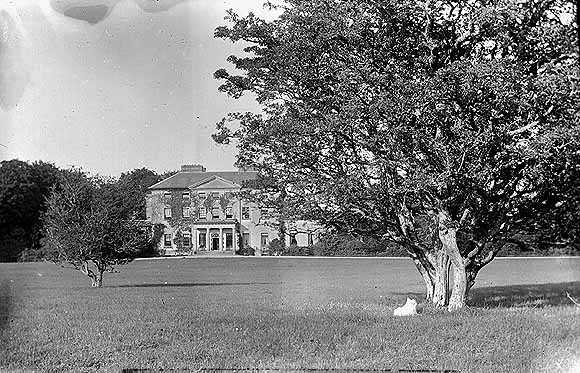
Ahascragh Glebe/Rectory
Houses within 5km of this house
Displaying 13 houses.
Houses within 5km of Ahascragh Glebe/Rectory
Displaying 13 houses.
| House name | Description | |
|---|---|---|
| Clonbrock | Designed by William Leeson and built in the 1780s. In 1837 Lewis recorded it as the seat of Lord Clonbrock. In 1786 Wilson refers to Clonbrock as the seat of R. Dillon. At the time of Griffith's Valuation the house at Clonbrock was valued at £100. In 1906 it was valued at £135. The house was badly damaged by fire in the 1980s and only one wing is now inhabited. |
|
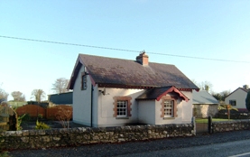
| Ballybaun | At the time of Griffith's Valuation, Lord Clonbrock owned a mill, gate house and other buildings valued at £35 in the townland of Ballybaun, parish of Ahascragh. The gate house is still extant and occupied. Local sources suggest it was at one time used as a school for children in the area. |
|
| Lowville | Lowville was originally the seat of Nathanial Lowe who held this estate in the mid-18th century and Wilson refers to it as his seat in 1786. In 1814 it was the residence of the Hon. Mrs. Low. In 1837 Lewis recorded Lowville as the seat of W. McDonagh. It was still occupied by Walter McDonagh in the 1850s and was valued at £45. By 1906 it was in the possession of Bernard Connaughton and was valued at £33. It was later the home of the Byrne family but was sold in the early 1970s and ceased to be residential. It is now a ruin. |
|
| South Park | At the time of Griffith's Valuation, Lawrence Kerrans was leasing a property valued at £11 from the Clonbrock estate at Kilglass, parish of Ahascragh. It is not named on the first edition Ordnance Survey Map but is labelled South Park on the 25-inch edition produced in the 1890s. The house is still extant and occupied. |
|
| Clooncannon/Cloncannon/Runnamead | Far Kelly was resident at Cloncannon in 1749. It is described in the Ordnance Survey Name Books as the residence of William Kelly. This property was offered for sale in the Encumbered Estates in July 1850. At that time it was occupied by Mathew C. Browne. John and Edward Lennon were occupying this property, valued at £9, at the time of Griffith's Valuation. It was part of a holding of almost 400 acres. Joseph Trumperant Potts laid the foundation stone for his house known as Runnymeade in 1866 (''Saunders Newsletter'', 23 June 1866). It is labelled as Runnamead House on the 25-inch Ordnance Survey map of the 1890s. In 1906 a house valued at £10 at Clooncannon Kelly was part of the Clonbrock estate together with almost 400 acres of untenanted land.. It is no longer extant. | |
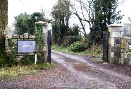
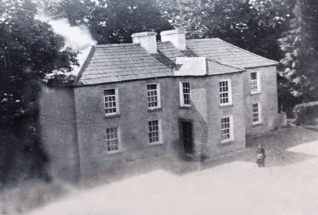
| Weston | John D. Mahon was leasing this property, valued at £35, from Sir William Mahon, at the time of Griffith's Valuation. It is described as unoccupied at the time of the first Ordnance Survey. The National Inventory of Architectural Heritage indicates that the original Weston house is now demolished. A smaller house, known as Weston Lodge, was also located in the demesne (M779403). It is no longer extant. |
|
| Ballyglass House | James Mahon, a brother of Ross Mahon of Castlegar, was residing at Balliglass in 1749. The Ordnance Survey Name Books record it as the residence of George Clarke in the 1830s. A herd's house valued at £5 and over 250 acres of the Mahon estate were located at Ballyglass in the parish of Ahascragh at the time of Griffith's Valuation. A house still exists at the site. | |
| Sonnagh | Walter McDonagh was leasing a property at Sonnagh, parish of Fohanagh, barony of Clonmacnowen, from the Clancarty estate at the time of Griffith's Valuation. He was also the occupier of a mill at Pollboy, valued at £95, in this parish. His estate was centred on Lowville in the barony of Kilconnell. A house still exists at the Sonnagh site. | |
| Fairfield (Kilgerrill) | Wilson, writing in 1786, notes Fairfield as the seat of Mr. O'Brien. In 1837, Lewis records Fairfield as the seat of John O'Brien. At the time of Griffith's Valuation Fairfield was leased by James Thorngate to Daniel Cruise. Taylor and Skinner record Fairfield as a seat of the O'Brien family in 1783. The original house is not extant. |
|
| Dalysgrove | The Ordnance Survey Name books describe Dalysgrove as the residence of Peter Daly and in good repair. At the time of Griffith's Valuation, Francis Daly was leasing the property at Dalysgrove valued at £32 from Peter Daly. The house was in the possession of Peter F. Daly in 1906. Sold by the Dalys in 1928, the shell of the house and parts of the walled garden remains. |
|
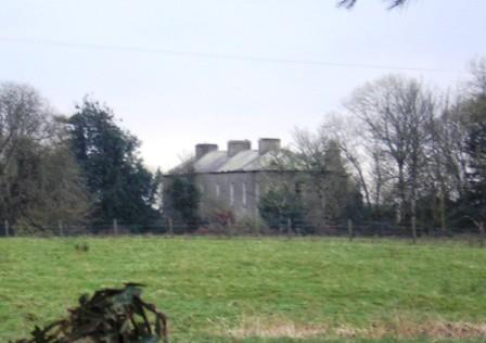
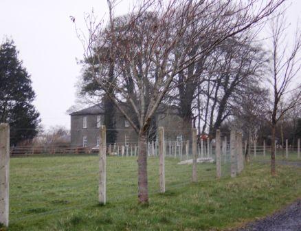
| Castlegar | The principal residence of the Mahon family, designed by Sir Richard Morrison circa 1801, replacing an earlier house. Wilson, writing in 1786, refers to this earlier house as the seat of Mr. Mahon. In the 1830s the Ordnance Survey Name Books describe it as in good repair but Sir Ross Mahon was not resident there at the time. Sir William Mahon was still in possession of the property in 1906 when it was valued at £67. In 1979 the house was sold by the Mahons to John Horan, who advertised the house for sale again in 1988. The house is still extant. |
|
| Milverton | Thomas Hunt was leasing a property valued at £20 from the Mahon estate at the time of Griffith's Valuation. Extensive corn mills are shown at this site at the time of the First Ordnance Survey but by the 1890s it is occupied by a house labelled Milverton which is still extant. |

|
| Killure | Writing in 1786, Wilson refers to Killure as the seat of Mr. Dillon. He appears to be referring to either Killure Castle or a property associated with it. The castle is described as "in ruins" on the 1st edition Ordnance Survey map of 1842 and the ruin of the tower house is still visible. |