Gallstown
Houses within 5km of this house
Displaying 15 houses.
Houses within 5km of Gallstown
Displaying 15 houses.
| House name | Description | |
|---|---|---|
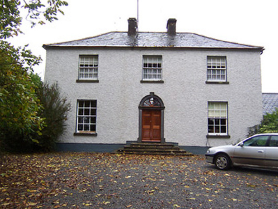
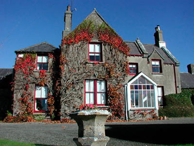
| Far View House | Far View House, an early 19th century two-bay, three storey house, originally a home of the North family. David North who married Catherine Pim was resident in 1837 and at the time of Griffith’s Valuation (publ. 1854), when the house was valued at £15 and held from Catherine Reynolds. The house was occupied by the Gavin family in the early 20th century. |
|
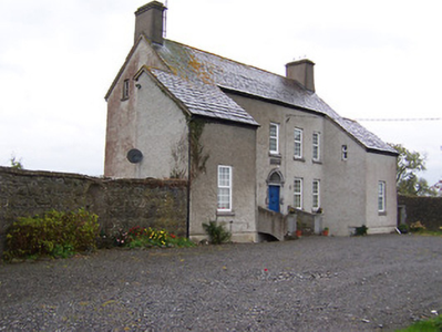
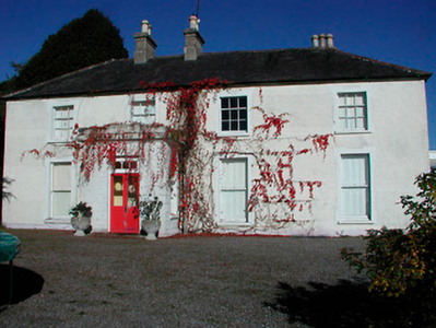
| West House | West House is a five-bay two-storey over a basement country, built about 1760, having projecting single-bay wings. O’Brien states that it was built by a family named West and that it was sold to Patrick Gavin in 1822 and that this family still live there. In 1814 it was the residence of Robert Johnston. At the time of Griffith’s Valuation (publ. 1854) it was valued at £9.10, occupied by Patrick Gavin and held from Catherine Reynolds. |
|
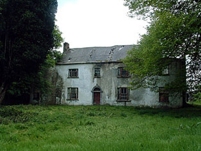
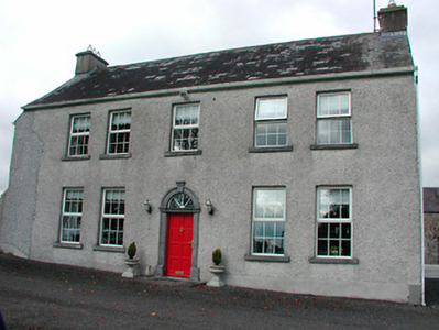
| Drumman Lodge | Drumman Lodge is named on first edition OS map. It is an early 19th century house of three-bays and two-storeys. In 1837 it was the home of T.M. Carew. At the time of Griffith’s Valuation (publ. 1854) Henry Green was the occupant, holding the house valued at £15 from an estate in Chancery, Rochfort v Brown. O’Brien writes that the Gavin family were resident between 1930s and 1980s and that the house has been recently restored. |
|
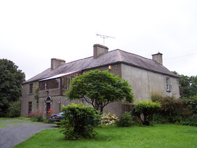
| Sidebrook House | Sidebrook house is marked on the first edition OS map and named on the 25 inch map. It is a four-bay two-storey house built in the early 19th century and may incorporate the fabric of an earlier house. Taylor and Skinner record a Rochfort Esq at Sidebrook in their maps surveyed 1777-1783. It was later in the ownership of a J. Rochfort in 1837. At the time of Griffith’s Valuation (publ. 1854) John Rochfort held the house valued at £11 with 600 acres from Cooper Rochfort. In the possession of the Lawrence family for most of the 20th century. |
|
| The Cottage | The Cottage, Gallstown, is named on both the first edition OS map and the 25 inch. This was the seat of the North family at the end of the 18th century (O’Brien). By 1814 Hugh Sheil was resident and Lewis records Mrs Sheil of The Cottage. This family was related to the Sheils of Gortlumly. The house was occupied by Margaret Sheil at the time of Griffith’s Valuation (publ. 1854), valued at £10 and held from Lord Kilmaine. Home of employees of Lord Kilmaine in the early 20th century. The house is no longer extant. | |
| Gortumly | Lewis refers to John Sheil of Gortumly and a long building is evident in this townland on the first edition OS map. O’Brien writes that the Sheils were resident at Gortumly from the mid-18th century. Gortumly house is named on the 25 inch map and is located just south of the long building on the first edition map. O’Brien writes that the Sheils bequeathed the house to a Mr O’Neill about 1910. Patrick O’Neill, a farmer and clerk to the County Council, was resident with his family in 1911. The lands were later sold to the Land Commission and the house demolished. | |
| Claremount House | The original house is named on the first edition OS map and the present house on the 25 inch map. It is a four-bay two-storey country house built after Griffith’s Valuation (publ. 1854) and replaced an earlier Claremount House, located to the northwest and marked on the Taylor and Skinner maps of the late 1770s, when occupied by Tyrrell Esq. From the mid-18th century this property was leased by the Tyrrells from the Rochforts of Belvedere. The present house was built and remained the home of the Ronaldsons until 2015 when it was advertised for sale. |
|
| Enniscoffey | Named on the first edition OS map and the 25 inch map, this was a late 18th century two-bay, two-storey house built in front of an older house. In 1837 Mark Anthony Levinge was residence, as he was also at the time of Griffith’s Valuation (publ. 1854), when the house was valued at £34 and held with over 900 acres from Daniel Molloy. Tenison Levinge and his wife were the occupants in 1901 and 1911. The house is now demolished. | |
| Woodville | Named on the first edition OS map, this is a three-bay two-storey over basement country house, built about 1785. At the time of Griffith’s Valuation (publ. 1854) it was the home of John G O’Keeffe, who held the house valued at £10.10 from Daniel Molloy. Functioned as a restaurant for a time and was recently for sale. |
|
| Gaybrook House | This house was built on land originally belonging to the Gay family who sold it to Ralph Smyth before the end of the 18th century. Smyth built the three-storey three-bay house which had extensive outbuildings and pleasure grounds as shown on the first edition OS map. Leet records him as the occupant in 1814 and his widow Mrs A Smyth was resident in 1837. Their son Robert was the occupant at the time of Griffith’s Valuation (publ. 1854) holding the house valued at £95 in fee. Col James Smyth and family were resident at the beginning of the 20th century. The house was demolished by the Land Commission about 1960 (boi). | |
| Rathcam or Lemongrove House | Rathcam House, previously known as Lemongrove, is a four-bay two-storey house, built about 1830 to replace an earlier house. Lemmongrove is marked on the Taylor and Skinner maps of the late 1770s occupied by Wilton Esq. Joseph Lemmon of Lemmongrove is mentioned in a deed of assignment dated 1771. Leet records Joseph Lemon of Lemongrove in 1814. Valued at £18, it was occupied by John ‘Lennon’ at the time of Griffith’s Valuation (publ. 1854) and held from Christopher Wilson [Wilton?]. The Lemons were still resident at the beginning of the 20th century. John D Lemon was the occupant in 1906 when the mansion house was valued at £23 and held with 262 acres of untenanted land. |
|
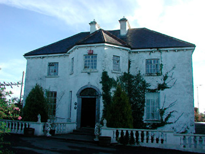
| Kilbride | Kilbride House is a three-bay two-storey house, built about 1810 to the north of Kilbride Castle. The Norths were in possession of Kilbride in the 18th century and Mrs North was resident in Kilbride House in 1814. The list of subscribers to Lewis’ Topographical Dictionary in 1837 includes A J Pilkington of Kilbride Castle. He was married to Mary daughter of Roger North. At the time of Griffith’s Valuation (publ. 1854) the house valued at £9 was occupied by Abraham Pilkington who held it from the representatives of R W Cooper. James King and family were resident at Kilbride in 1901 and 1911. |
|
| Dunboden Park | Dunboden Park is named on the first edition OS map with pleasure grounds to the east. A late 18th century neoclassical country house built by the Rochforts, one of whom was murdered on the steps of the house in 1797. The house was reputedly remodelled by Sandham Symes (1807-1898), about 1860 for the Cooper Family of Markee Castle, county Sligo (boi). The Coopers purchased the estate after the death of Robert Rochfort in 1797 and remained in possession until the early 20th century. At the time of Griffith’s Valuation (publ. 1854) the house, offices, gatelodge and lodge were valued at £73. Anne Cooper was resident holding the property from Abraham Pilkington. By 1906 the valuation had increased to £93 and Colonel Edward Cooper was the occupant. The house was burnt in 1923. A mausoleum to Joshua Harry Cooper who died 1819 is located to the south of the ruins of the house. |
|
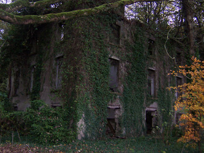
| Whitewell House | Originally a home of the North family and occupied by Arthur Grose in 1837. At the time of Griffith's Valuation (publ. 1854) Whitewell was the residence of John G Battersby MD, valued at £9.10 and held from John North. O'Brien records that Elinor widow of John Roger North died here in 1858 and that the lands and house were leased to Laurence and Michael Gavin in 1859. The Gavins still own the lands but the house is a ruin. | |
| Tyrrellstown | Tyrrellstown House, named on the first edition OS map, was a five-bay two-storey house, built c.1790, against the side of a Tyrrell tower house, probably by the Bomford family. Tyrrellstown House was the home of Benjamin Briggs in 1814 and of a Mr Briggs in 1837. At the time of Griffith’s Valuation (publ. 1854) John McCulloch held the house valued at £12 from David North, a nephew of Isaac Bomford. Purchased by the Ronan family in the 20th century. It is now demolished. |
|