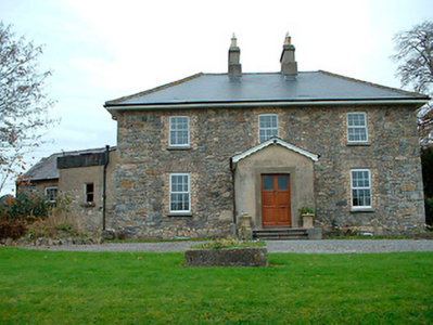
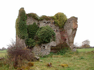
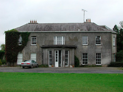
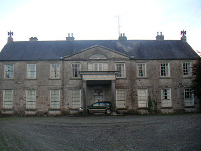
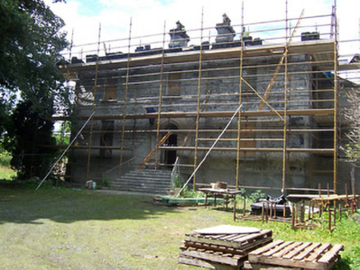
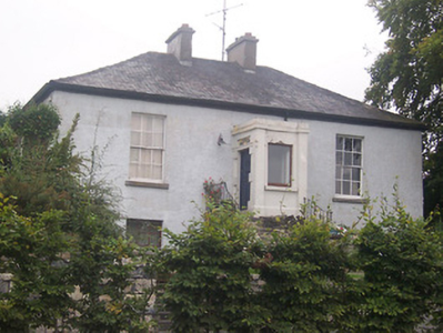
Clanhugh
Houses within 10km of this house
Displaying 42 houses.
Houses within 10km of Clanhugh
Displaying 42 houses.
| House name | Description | |
|---|---|---|
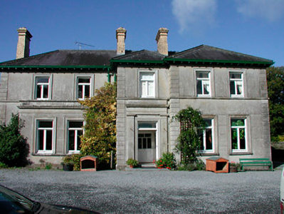
| Grange Hall | The building at this site on the first edition OS map is named Orange Hall and Grange Hall on the 25 inch map with a courtyard and laid out gardens. At the time of Griffith’s Valuation (publ. 1854) Owen Evers or Eivers owned and occupied the house, valued at £16. This property belong to Eugene Eivers in 1870, who owned 107 acres of land in the area at the time. The Eivers were still resident in 1906 and 1911 and the house remains a well maintained residence. |
|
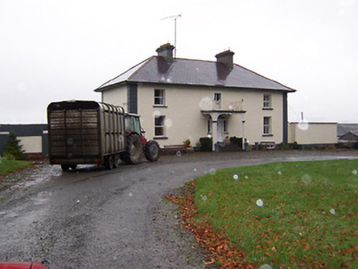
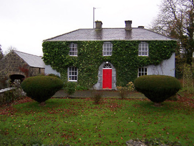
| Ballysallagh House | Ballysallagh house is not marked on first edition OS map. It is a three-bay two-storey late-Georgian-style farm house, built about 1850. At the time of Griffith’s Valuation (publ. 1854) it was occupied by Christina McCormick, who held the house valued at £11 from William Longworth. It is still in use as a residence. |
|
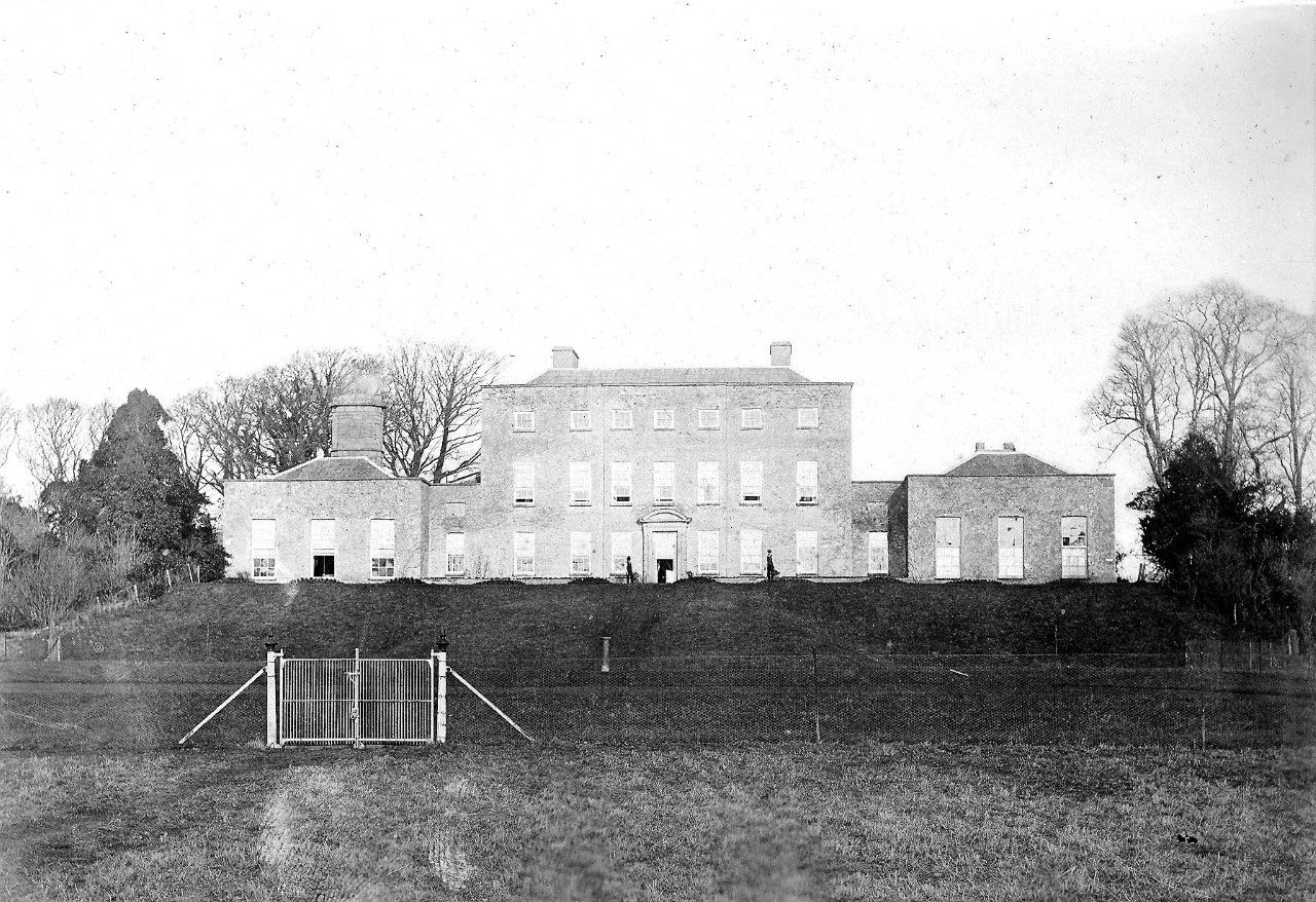
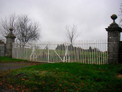
| Baronstown | Baronstown was a large mansion in an extensive demesne on the western shore of Lough Iron, as shown on the first OS map, with many features such as a temple, summer house etc. Described by the National Built Heritage Service as an important late eighteenth-century Palladian villa with two storey wings, it was associated with the Malone Family/Lord Sunderlin. Taylor and Skinner noted it as a Malone property in 1777. Lord Sunderlin was resident in 1814. Following the death of Richard Malone in 1837 his sister Alicia who had married Henry O’Connor of Mount Pleasant, King’s County (Offaly) succeeded to the Baronstown and Shinglis estates. O’Brien writes that the building was burnt twice and rebuilt. The first time in 1889 and the second time in 1903 when it was replaced by a large Tudor villa to designs by James Franklin Fuller. In 1906 it was valued at £70 and was occupied by Colonel John R Malone who held it with 943 acres of untenanted land. Demolished by the Land Commission in the 1920s, it is now a greenfield site. |
|
| Oran Vale | Located directly north of Ballynacarrigy, Oran Vale is named on the first edition OS map and was occupied by J Irwin in 1837. Valued at £15 it was unoccupied at the time of Griffith’s Valuation (publ. 1854) while the immediate lessor was Thomas William West who held the property from Alicia O’Connor Malone. The house is not named on the 25 inch map and is now a ruin. | |
| Willybrook/Willifield | This house is named Willybrook on the first edition OS map and as Willifield on the 25 inch map. Valued at £12 at the time of Griffith’s Valuation (publ. 1854), it was occupied by Joseph Evers who held it from Alicia O’Connor Malone (in Chancery) and remains a well maintained residence. |
|
| Kill House | Kill house marked on first edition OS map and the 25 inch map is located a short distance west of Sonna. At the time of Griffith’s Valuation (publ. 1854) it was valued at £17, occupied by Maria McCormick and held from George Thompson. It appears to be still extant with courtyard outbuildings. | |
| Rath House | Rath House, was the home of J West in 1837 and of Thomas West at the time of Griffith’s Valuation (publ. 1854), when the buildings, including a corn mill, were valued at £34 and held from Alicia O’Connor Malone. In 1906 the mansion house of Rath valued at £30 was in the occupation of Colonel John R Malone and was held with 62 acres of untenanted land. The census records would suggest that the local rector Rev Venn was actually resident. The house is now demolished. | |
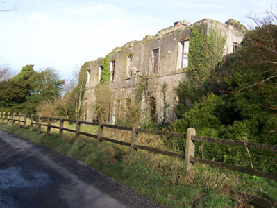
| Tristernagh House | Described as an imposing and dramatic ruin with an interesting and varied history Tristernagh was originally an important Augustinian Abbey, founded c. 1200 by Geoffrey de Costentin (boi). After the dissolution of the monasteries and abbeys it was granted to the Piers Family, Elizabethan settlers. In 1783 Sir William Pigot Piers turned part of the building into a residence, which is named as Tristernagh House on the first edition OS map. It was unoccupied in 1814. A new house/cottage was built to the north of the abbey in the early nineteenth-century which is marked on the first edition OS map (N332 616). It is not clear which of these houses Lewis is referring to as the seat of Sir John Piers Bt in 1837. The 25 inch map of the early 20th century named this later building as Tristeragh House, while the original Tristeragh House at the abbey site was a ruin. Woods writes that the ‘late J Eivers Esq, J.P., lived for years in the cottage built by the late Sir John Piers’ while the mansion built by Sir Pigot William Piers in 1783 was ‘a crumbling ruin’. At the time of Griffith’s Valuation (publ. 1854) James Evers was recorded as the occupant of a house at Tristernagh valued at £10 held from Hamilton Geale. Shepherd Patrick Garry with family members was living here in 1901 and 1911. They held the house from Colonel John R Malone. The house is still extant. |
|
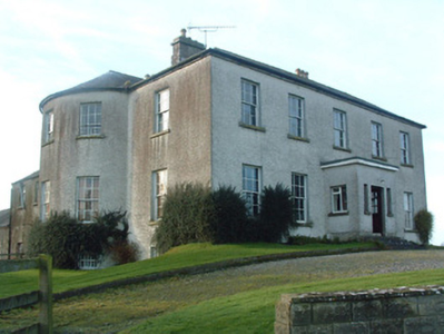
| Ardglass House | This house was rebuilt in the style of an Italianate Villa post Griffith’s Valuation, possibly incorporating the fabric of an earlier house on the same site. The original Ardglass House was the home of a Major A. P. Bond in 1837. Valued at £13.15 at the time of Griffith’s Valuation (publ. 1854), it was occupied by the representatives of A P Bond who held it in fee. The present house was in the ownership of William Perry Bond JP, in the 1880s. The house has had various owners in the 20th century and was for sale in 2017, see https://www.businesspost.ie/article/high-class-at-ardglass-co-westmeath/ | |
| Newpark Lodge | Newpark Lodge named on both the first edition OS map and the 25 inch map. Occupied by James Auchmuty JP in 1837 and at the time of Griffith’s Valuation (publ. 1854) when he held the house valued at £10 from the representative of A P Boyd. Now a modern building located at the site situated on the main road from Mullingar to Edgeworthstown. Newpark Lodge was for sale in 2021. | |
| Knocknacreeve House | A building is marked at this site on the first edition OS map and a building of a different shape named Knocknacreeve House on 25 inch map. Richard Ham occupied this house valued at £14 which he held from Robert Smith, at the time of Griffith’s Valuation (publ. 1854). It is now the centre of a farm complex of buildings. | |
| Sonna | Set in a substantial demesne as shown of the first edition OS map, the building is slightly altered in shape from this map to the 25 inch map. The house was a three-storey, seven-bay mid-18th century Palladian style mansion. It was the home of the Tuite family and remained as such until it was burnt in 1921. Described in 1837 by Lewis - ‘Sonna for upwards of six centuries, the seat of the Tuite family, is at present the residence of Hugh Morgan Tuite… the house is a light and elegant building, in a well planted demesne’. O’Brien gives a detailed account of the family. The estate consisting of 638 acres was sold to the Land Commission in 1928. See https://www.tuites1.com/424198848.html |
|
| Coolure | Coolure was held in fee by Sir Richard Pakenham at the time of Griffiths Valuation in the early 1850s when it was valued at £84. The National Built Heritage Service suggests it was built c.1775 with a later extension in the 1820s. It was likely built for Captain (later Admiral) Thomas Pakenham on his marriage to Louisa Staples, who were the parents of Sir Richard Pakenham. In 1906 it was part of the estate of Hugh P. Wilson and valued at £24. Coolure is still extant and occupied. Its extensive stable block was located in the neighbouring townland of Lispopple and was valued at £9 at the time of Griiffiths Valuation. |
|
| Wilson's Hospital | Wilson's Hospital School erected on the summit of a hill, was founded by a trust set up by Andrew Wilson of Piersfield [Piercefield]. The National Built Heritage Service records that Wilson stated in his will of 1724 that in the event of there being no direct male heirs to his estate that it, and all its profits, be transferred to the Church of Ireland hierarchy and used to build a hospital for aged Protestant men and a school for poor Protestant boys. This was the case by 1743 and the school was completed in 1761. ‘Wilson's Hospital is one of the finest and most sophisticated mid-Georgian buildings constructed outside of Dublin. Its design has been attributed John Pentland, a noted architect of his day, and it is built in the style of a Palladian country house’ (boi). It is a seven-bay two-storey building which was valued at £90 at the time of Griffith’s Valuation (publ. 1854) and continues to function as a secondary co-educational boarding school today. | |
| Lackan | Lackan house is marked but not named on the first edition OS map. It was a two-storey, three-bay house, the home of the Delamare family, long associated with the Multyfarnham area. The Taylor and Skinner maps of the late 1770s include reference to Delamar at Lacken. In 1837 Lackan was the seat of Mrs Delamere. It was unoccupied at the time of Griffith’s Valuation (publ. 1854) when valued at £17. The immediate lessor was Patrick J Murphy. A number of Delemere families were still resident in the townland in 1901. This house has been demolished. | |
| Rathbennett House | Rathbennett House, formerly known as Farra House, originally functioned as Bunbrosna Charter School. Built c.1758 with a bequest from the will of the Rev. William Wilson, the nephew and heir of Andrew Wilson, the benefactor of Wilson's Hospital. Farra Charter School is recorded by Lewis in 1837 and was still recorded as a charter school with offices at the time of Griffith’s Valuation (publ. 1854) when the building was valued at £30. It was held by the trustees of Wilson’s Hospital in fee. Sometime later it became a private residence. Occupied by Thomas Cartret Foster in 1901 and 1911, this house remains a family home. |
|
| Ballinacloon | Ballynaclonagh, named on the first edition OS map as Ballynaclonagh and on the 25 inch map as Ballinacloon and extended. No longer extant, demolished c 1930. Complex of single and two-storey outbuildings on L-shaped plan survive. Ballynaclonagh was the residence of Edward Murphy in 1814 and P. E. Murphy in 1837. Griffith’s Valuation (publ. 1854) records Patrick E Murphy as the occupier holding the property valued at £33.5 in fee. Patrick Delamere, coachman to Captain Murphy, was resident with his wife in 1901. Valued at £45.5 in 1906 and in the possession of Captain Laurence Murphy. The Delameres had three children by 1911 and were resident holding the property from Mrs Sarah Murphy. | |
| Donore House | Donore overlooking Lough Derravaragh, named on the first edition OS map. The Nugents were settled here from the 16th century. Donore House was a three-storey late 18th century Georgian block. James Nugent of Donore was created a baronet in 1768. When his brother Peter the second baronet died in 1797, Donore passed to the family of their sister Catherine who had married Pierce Fitzgerald of Baltinoran. They had two sons Thomas who inherited Donore and Lattin who inherited Soho House. In 1831 Thomas’ son Percy Fitzgerald Nugent was created a baronet and was MP for Westmeath 1847-1852. He was resident at the time of Griffith’s Valuation (publ. 1854) when the house was valued at £80. The Nugents were still resident in the early 20th century. O’Brien writes that the house was given to the Franciscan Community of Multyfarnham from whom it was purchased by the Land Commission. The house fell into disrepair and was demolished in the 1960s. | |
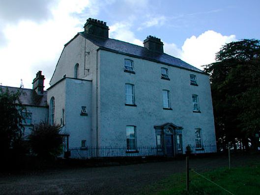
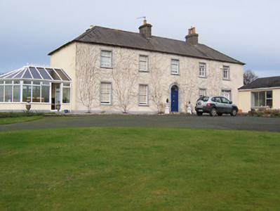
| Monintown/Mornington | Monintown or Mornington House, straddles the border between the parishes of Mutlyfarnham and Stonehall as shown on the first edition six inch OS and the 25 inch maps as Moninton. The original two-storey house was built in the mid-18th century and was the home of the Daly family. It was the seat of Owen Daly in 1837 and Edward Daly held it in fee at the time of Griffith’s Valuation (publ. 1854). It was valued at £7.10, while a building he held in the parish of Stonehall was valued at £8. In the late 19th century a five-bay two-storey house was built to the front of the original house by the O’Hara family who acquired the property in 1858. In 1906 the house was valued at £43.13 and was in the possession of Patrick O’Hara. Still in the ownership of the O’Haras, who run it as a guest house. |
|
| Soho (Multyfarnham) | Soho, an early 19th century three-bay two-storey house, is named on the first edition OS map. Inherited by Lattin Fitzgerald, a younger son of Catherine Nugent of Donore and her husband Pierce Fitzgerald, who occupied the house in 1814. At the time of Griffith’s Valuation (publ. 1854) it was the residence of Peter Nugent Fitzgerald, valued at £15.15 and held from Sir Percy Nugent of Donore. The house was occupied by Mrs Margaret Fitzgerald’s gardener Edward Fay in 1901 and by Colonel Edward Irwin and family in 1911. Soho is still a family home. |
|
| Portloman | Portloman, situated on the shore of Lough Owel, is named on the first edition OS map and the 25 inch map. Home of the de Blaquiere family from the mid-18th to the mid-19th centuries. Both Leet (1814) and Lewis (1837) record Portloman as the seat of Lord de Blaquiere. At the time of Griffith’s Valuation John de Blaquiere held the house valued at £18 in fee. When the estate was for sale in June 1866 the mansion house was described as been ‘beautifully situated on the margin of Lough Owel and stands upon a demesne containing about 200 acres Statute measure, handsomely planted, to which is attached a large garden, containing over three acres well stocked, walled in and lined with Brick; Hot Houses, Conservatories etc’. In 1906 the house was in the possession of Colonel David W Stevenson [of Derry]. The buildings had increased in value to £33.10 and were held with 142 acres of untenanted land. This house was destroyed in 1921. | |
| Woodland | Woodland overlooking Lough Owel, named on the first edition OS map and 25 inch map, still extant but now known as Ardilaun House. Lewis records W Moxton, agent to Lord Forbes, as the occupant in 1837 and at the time of Griffith’s Valuation (publ. 1854) Edward Maxton was resident holding the property valued at £14 from Lord Forbes. In 1901 occupied by race horse trainer Alexander Pilkington and his wife and by the Brabazon family, horse trainers in 1911. | |
| Ballynagall | Ballynagall, a six-bay two-storey Regency style house, built in the early 19th century for James Gibbons at the cost of £30,000 (Lewis) and was reputedly built using the fabric of an existing castle on site, known as Castle Reynell (boi). Reynell of Castle Reynell is recorded on the Taylor and Skinner maps of the late 1770s. The interior plasterwork was executed by George Stapleton, son of the stuccadore Michael Stapleton. The Smyth Papers in the National Library contain letters to James Gibbons from John Robinson and Francis Johnston relating to the building of Ballynagall, 1810-1815 (Mss 18,926-18,927). Ballynagall remained in the possession of the Gibbons family until 1846 when ownership passed to James Middleton Berry, nephew of James Gibbons. At the time of Griffith’s Valuation (publ. 1854) the buildings were valued at £110 and held by JWM Berry in fee. Inherited by Thomas James Smyth of the Drumcree family in 1855, it remained in Smyth ownership until sold in 1963 (O’Brien). It is now a ruin. |
|
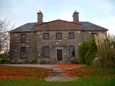
| Mount Murray | Mount Murray House is situated facing the western shore of Lough Owel and is named on both the first edition OS and 25 inch maps. The Murray family have been resident here since the mid-17th century and remain in residence today. The present house is a five-bay two-storey over basement country house, built about 1780 and remodelled c.1820 with the addition of a semi-circular bow to the southeast façade (boi). It was built by Alexander Murray in the late eighteenth-century to replace an earlier Murray house or castle close to the same site. Occupied by Alexander Murray in 1814 and 1837 and by Henry Murray at the time of Griffith’s Valuation (publ. 1854) who held the house valued at £46 in fee. William Murray was resident in 1906. |
|
| Martinstown | Martinstown is marked on the first edition OS map but is named on the later 25 inch map. It was built c.1820, on a L-shaped plan with two-storey return to the rear (boi). John Kerr held most of this townland from Thomas R Evans at this time and occupied the house valued at £12. Other Kerr family members occupied houses valued at £7 and £8.10. |
|
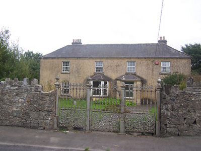
| Kilmaglish | Kilmaglish House not built at time of first edition OS map but is marked on the 25 inch map. At the time of Griffith’s Valuation (publ. 1854) it was valued at £17, occupied by William Levinge and held from Sir Richard Levinge. Occupied by Thomas Robinson, a farmer and his son William in 1901 and 1911. It is still extant surrounded by large farmyard. | |
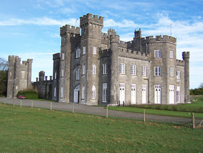
| Knockdrin Castle | A Gothic Revival castle built about 1815; it is not recorded by Leet. Located east of Lough Owel and north of Lough Drin, this castle was built by Sir Richard Levinge (1785-1848) 6th Bt to replace High Park, the Levinges’ old family home and was designed, most probably, by James Shiel. It was valued at £100 in 1906. The Castle remained the home of the Levinge family until the mid-20th century when it was sold. It is now the home of the Prondzyunski family. |
|
| Rathconnell Court | Rathconnell Court is named on the first edition OS map and marked as ruins on the 25 inch map of the early 20th century. It was the home of the Adams family and was marked on the Taylor and Skinner maps of the 1770s. Occupied by Francis Adams in the early 19th century and by J Adams in 1837. Francis Adams was resident at the time of Griffith’s Valuation (publ. 1854) holding the house valued at £18 in fee. | |
| Ballinderry Cottage | Ballinderry cottage, named on both the first six inch and 25 inch maps, Ballinderry was originally a home of William Judge of Mosstown (O’Brien). Located on the southern outskirts of Mullingar, at the time of Griffith’s Valuation (publ. 1854) Godfrey Fetherstonhaugh held the building valued at £11 from Anne ‘Cowper’ or Cooper. Home of the Bayley family at the beginning of the 20th century. O’Brien writes that a hospital now stands on the site. | |
| Ballyglass | Ballyglass, a four-bay two-storey house, built about 1820, is named on both the first six inch and 25 inch OS maps and located just north east of St Finian’s College near Mullingar. In 1814 it was the home of John McLaughlin. At the time of Griffith’s Valuation (publ. 1854) James William McLoughlin resided, holding the house valued at £16.10 in fee. This house is still extant. |
|
| Charlestown House | Charlestown House, Balnamona, is named on both the first six inch and 25 inch maps. It was the home of Tennison Lyons in 1814. Hill J M Walsh was resident here at the time of Griffith’s Valuation (publ. 1854) when the house was valued at £15 and held from John C Lyons. There is a building still on the site, part of Charlestown stud. | |
| Clonard House | Bellview, now known as Clonard House, is a two-bay two-storey over basement house, built about 1800, located in the town of Mullingar, home of the Walsh family. Robert Walsh was resident in 1814 and Thomas Walsh in 1837. He was still resident at the time of Griffith’s Valuation (publ. 1854), when the house was valued at £40 and held in fee. In 1876 Thomas Walsh of Bellvue owned 528 acres. In the mid-20th century this house was the residence of the Catholic Bishop of Meath. Since then it has been a tourism headquarters and an entertainment venue (O’Brien) and was for sale in 2022. |
|
| Culleen House | Culleen House is marked on the first edition OS map and had greatly expanded by the time of 25 inch, only the outbuildings remain now. O’Brien describes it as long, low seven-bay, two storey early Victorian house, purchased by Mr Mc Loughlin, a Dublin merchant, from Sir John de Blaquiere of Portloman. A Thomas McEvoy occupied Culleen in 1814. It was later sold to Godfrey Levinge, a grandson of the 4th Baronet, who was resident at the time of Griffith’s Valuation (publ. 1854), holding the house, valued at £30 in fee. Home of Thomas M Reddy and family at the time of the 1901 and 1911 censuses. This house is no longer extant. | |
| Bellmount House | Bellmount House, Curristown, is named on both the first six inch and 25 inch OS maps. It is a five-bay two-storey house, built about 1820. Although built on part of the Lyons of Ladestown estate, Bellmount House was in the possession of the Reilly family for most of the 19th century. The two families were related. In 1814 John Lyons is recorded as the occupier and in 1837 W Reilly. At the time of Griffith’s Valuation (publ. 1854) William Haig was resident holding the house valued at £36 from the representatives of Anthony A Reilly. Home of Arthur and Alice Trevor Booth in 1911. In the mid-20th century O’Brien records that Bellmount was in the ownership of the Gainsford-St Lawrence family of Howth Castle, Dublin. |
|
| Levington Park | Levington Park is located close to the southern shore of Lough Owel. The seat of a branch of the Levinge family from the mid-18th century, it is a nine-bay two-storey country house with two-storey returns to the rear at either end (north and south), built about 1748 by Sir Richard Levinge 4th Baronet and altered in the early 19th century (boi). In 1814 Lady Levinge was resident. It was inherited by the 4th Baron’s second son Richard Hugh Levinge who was the owner in 1837. Valued at £27 at the time of Griffith’s Valuation (publ. 1854), occupied and held by Charles William Levinge in fee. Members of the Levinge family were still resident in 1901 but Hugo Fitzpatrick and his wife Gertrude were living here in 1911. O’Brien writes that Levington Park was later the residence of Edmund Dease, formerly of Turbotstown House. His son Maurice was the recipient of the first posthumously awarded Victoria Cross of World War I. The house had other owners until purchased by the author J P Donleavy in 1972. He died in 2017. |
|
| Annebrook | Annbrook or Annebrook in the town of Mullingar was originally a three-bay two-storey over basement house, built about 1810. It was the home of Dr Robert Barlow in 1837 and at the time of Griffith’s Valuation (publ. 1854), when it was valued at £38 and held from the Earl of Granard. Still a doctor’s residence in 1911 when Dr Joseph Dillon Kelly and his wife lived at Annebrook. Now functions as a hotel, the Annebrook House Hotel. See https://www.annebrook.ie/ |
|
| Monte Video/Prospect | This house was named Monte Video on the first edition OS map and as Prospect on the 25 inch map. A doctor’s residence at the time of Griffith’s Valuation (publ. 1854) when Dr Ferguson was in occupation. Valued at £13 it was held from Anne Cowper or Cooper. It was originally located on the outskirts of Mullingar but is now surrounded by a housing estate |
|
| Springfield (Mullingar) | Springfield, on the outskirts of Mullingar, is named on both the first six inch and 25 inch maps. At the time of Griffith’s Valuation (publ. 1854) it was occupied by Thomas Tuite, held from Charlotte Tighe and valued at £20. Now demolished and replaced by Assumption Villas. | |
| Greenpark House | Greenpark House, previously known as Tuitestown, located south west of Mullingar, now a green field site. Members of the Hudson/Hodson family lived here as recorded on the Taylor and Skinner maps of the late 1770s when the property was known as Tuitestown and in Leet’s directory of 1814 when Hartley Hudson was resident at Greenpark. By the time of Griffith’s Valuation (publ. 1854) Elizabeth Connolly was occupying the house, valued at £28 and held from Sir George Hodson. |
|
| Gartlandstown House | Gartlandstown House, located at the south eastern toe of Lough Derravargh, is a five-bay two-storey house, built about 1830 (boi) or perhaps replacing an earlier house as Garlandstown, Castlepollard, was the seat of Sterne Tighe in 1814. By 1837 J Murray was resident here and James Murray is recorded as the occupant at the time of Griffith’s Valuation (publ. 1854) when the house was valued at £10 and held from James W M Berry. O’Brien writes that Michael Hope was resident in 1869 and in the mid-1870s the representatives of Michael Hope held 487 acres at Gartlandstown. Members of the Hope family was still in occupation at the time of the 1901 and 1911 censuses. |
|
| Benison Lodge | Benison Lodge, west of Lough Lene, is named on both the first edition six inch and 25 inch OS maps. O’Brien describes it as a late 18th century, five-bay, two-storey house, probably by the O’Reilly family, one of whom was shot dead in the house in 1803 by the coachman. In 1814 Thomas H Smyth lived here and the Rev T Smyth in 1837. By the time of Griffith’s Valuation (publ. 1854) John Henry Roper was occupying the house, valued at £30 and held from William P Urquhart of Castlepollard. In the 1870s Henry J Roper of Benison Lodge owned 447 acres. In the early 20th century Richard O’Neill and family were living in a first class house in this townland. The house is now a ruin. | |
| Derrya | At the time of Griffiths Valuation in the early 1850s William Pollard Urquhart was leasing a herd’s house at this location from the estate of Richard Pakenham, when it was valued at almost £11. The Valuation Office books of 1839 noted the owner as Captain William Pakenham and the valuation was £12. The Untenanted Demesnes survey of 1906 indicates it belonged to Hugh P. Wilson and was valued at over £10. The building is still extant but derelict. |