Corravahan House
Houses within 5km of this house
Displaying 5 houses.
Houses within 5km of Corravahan House
Displaying 5 houses.
| House name | Description | |
|---|---|---|
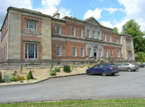
| Ballyhaise | Ballyhaise built for Colonel Brockhill Newburgh, design attributed to Richard Castle but more likely Sir Edward Lovett Pearce, early 18th century. About 1800 sold to Williamm Humphrys who added two storey wings to the building. Lewis describes the house in 1837 as ‘a spacious mansion, with an elevated front curiously ornamented with arches’. It was the seat of William Humphrys. In the 1850s the buildings had a rateable valuation of £110. Since 1905, Ballyhaise has been an agricultural college. |
|
| Clonervy | In 1814, Clonervy was the home of Richard Blackwood. Located on the estate of Earl Annesley it was vacant at the time of Griffith’s Valuation when its rateable valuation was recorded as £30. George Graham occupied Clonervy in the 1860s and in 1880 it was the residence of the subsheriff John Maxwell James Townley. The Irish Builder records plans for general repairs to Clonervy House for Patrick Lyons in 1912. A smaller building still occupies this site. | |
| Lisnagowan House | Built as a dower house for the wife of William Humphrys who bought Ballyhaise about 1800. In the-mid 1830s occupied by Mrs Humphreys as stated by Lewis. Griffith’s Valuation records William Humphrys as the occupier, holding the property in fee. Still the home of a member of the Humphrys family in 1901. Richard Weir and his wife occupied the house in 1911 holding it from Nugent W. Humphrys. Damaged by fire in the early 20th century, the building is now a ruin. See http://cvn049.blogspot.ie/2016/03/lisnagowan-house.html for photo. | |
| Lislin House | Lislin House, situated close to the bank of the Annalee River, is named on the first edition six inch Ordnance Survey map (publ. 1837). The building is believed to date from the late 18th century and came into the possession of the Battersby family through marriage. At the time of Griffith’s Valuation Robert Battersby was the occupier and owner. The rateable valuation of the buildings was £6. Home of the James and Agnes Simons at the beginning of the 20th century, now a ruin. | |
| Countenan House | Countenan House on the shore of Countenan Lough is named on the first edition six inch Ordnance Survey map (publ. 1837). It was occupied by Thomas Hartley in the 1850s and held from Robert Burrowes. The rateable valuation was £10.10.0. Home of the Hawe family at the beginning of the 20th century, this house is apparently still attached to a farming enterprise. |