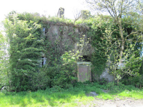
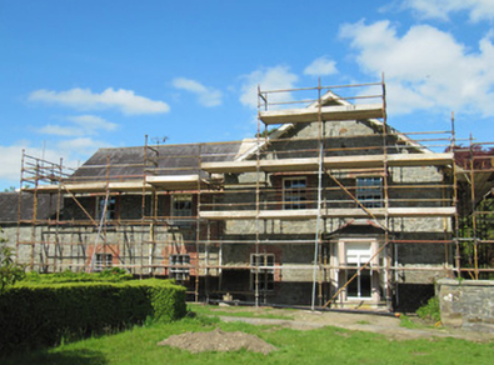
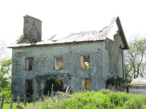
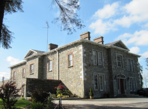
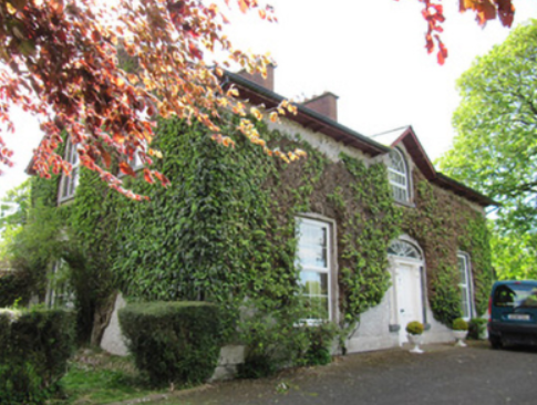
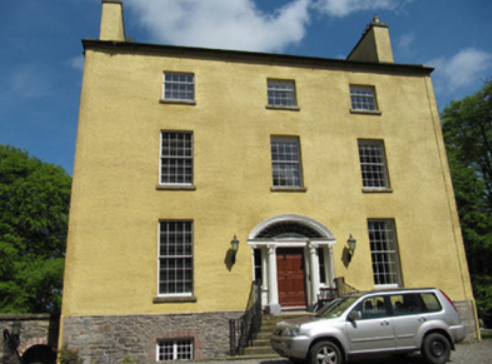
Shinan House
Houses within 15km of this house
Displaying 55 houses.
Houses within 15km of Shinan House
Displaying 55 houses.
| House name | Description | |
|---|---|---|
| Mount Carmel | A house built in the early 19th century; the Tithe Applotment Book 1829 records the occupant as John Ker while the Ordnance Survey Field Name Book records Miss Kerr as resident. William Alexander Williams of Mount Carmel, a nephew of Colonel John Ker of Mountain Lodge, took the additional name of Ker in 1846. Mount Carmel was advertised for sale in 1854. It was unoccupied at the time. By the time of Griffith’s Valuation the buildings had a rateable valuation of £7 and the house was occupied by George Bennie and held from Samuel Moorhead. This house continues to be a well maintained residence. |

|
| Mountain Lodge/Farmoyle House | This house was originally known as Mountain Lodge but in more recent times the name Farmoyle House has been used. In the 1830s it was the residence of Colonel John Ker, who was succeeded by his nephew William Alexander Williams. In January 1851 the Mountain Lodge estate of W. A. Williams Ker was advertised for sale in the Encumbered Estates Court, with an estate in county Meath. The mansion house was at the time occupied by Mrs Ann Ker, aged 83 years, widow of the Colonel. It was purchased by George Bennie, who held it in fee at the time of Griffith’s Valuation but was selling it in 1865. By the time the 25 inch Ordnance Survey map was compiled the building was reduced in size and has been further altered in more recent times. The National Inventory of Architectural Heritage records the building as unoccupied. |

|
| Milmore/Millmore | A home of the Breakey family in the early 19th century. The Ordnance Survey Field Name Book refers to a gentleman’s seat in the north of the townland of Derry and the house is marked on the first edition 6 inch Ordnance Survey map. Lewis refers to Milmore as the home of ‘the late T. Brunker’. It was occupied by John F. Johnston in the mid-19th century, valued at £22 and held from John Leslie. In 1876, John F. Johnston of Australia owned 143 acres in county Monaghan. Captain Francis Johnston of Milmore House, a veteran of the Peninsular War, died in 1862. A house is still extant at this site. | |
| Corfad | Built in 1828, according to the Ordnance Survey Field Name Book, this two storey house was the residence of ‘Mr McCullough an extensive farmer’. Griffith’s Valuation records James McCullagh as the occupier who held the property which included offices, corn and flax mills, in fee. The buildings were valued at £42. This house is now a ruin. |
|
| Shantonagh House | Lewis writes in the 1830s of Chantinee ‘in the demesne of which are some fine waterfalls’ the home of J. Tilly Forbes. In the early 19th century Chantinee or Chantony was visited by Maria Edgeworth on one of her tours when the house was occupied by James Corry. The first edition 6 inch Ordnance Survey map shows a house in the townland of Shantonagh but there is a larger house in the townland of Tooa which on the 25 inch map is named Shantonagh House. At the time of Griffith’s Valuation this house was valued at £25 and held by Thomas Rothwell in fee. It was burnt in early July 1921. | |
| Farm Hill | A house marked on the 1st edition Ordnance Survey map with a corn mill nearby. This house looks reduced in size on later maps. In the mid-19th century occupied by Hugh Swanzy and held from Thomas Rothwell. The house was valued at £15 with corn and flax mills and miller's house valued at £35. Part of the existing farmyard may date back to circa 1800. |

|
| Donaghmoyne | Donaghmoyne House is named on the 1st edition 6 inch Ordnance Survey map (1836) and the grounds include a walled garden and plantations. A mill and quarry were located nearby. Lewis records Donaghmoyne as the residence of J. Bashford. John Dixie, who had oil and flax mills near the house, was the occupier in the mid-19th century. He held the property, described as a steward’s house, from the Reverend Robin L. Tottenham, whose estate was at that time in the Court of Chancery. The buildings which included a gate lodge were valued at £17. Donaghmoyne was purchased by Richard Bolton from the Reverend Tottenham in the early 1860s. John Marshall Bolton and his wife were resident in the early 20th century. This house is still a residence. |
|
| Laragh (Aghnamullen) | A house originally associated with the linen industry, the Ordnance Survey Field Name Book refers to Laragh as the property of Mr W. Intire of Belfast, containing the residence of the proprietor of the bleaching green Mr Davidson. Lewis also records A. Davison as resident at Laragh. Eliza McKean was the occupant of the house valued at £20 in the mid-19th century. She held the property from George McTear. The National Inventory of Architectural Heritage indicates that the present house was built circa 1860 on the site of an older house. The McKean family were still resident in 1901 and 1911. The 'mansion house' had a rateable valuation of £20 in 1906 when James M'Kean held 142 acres of untenanted land in Laragh and Cornacarrow. |
|
| Cherry Vale (Aghnamullen) | Located at the southern tip of Lough Egish, Cherry Vale was situated in the midst of a linen manufacturing enterprise. Some deeds record George Crawford, linen draper, of Cherryvale at the end of the 18th century. Cherry Vale became part of the McTear of Belfast estate. The Ordnance Survey Field Name Book records the house as small with two stories. At the time of Griffith’s Valuation it was occupied by Thomas Johnston, who held it from Eliza McKean who in turn was leasing from George McTear. | |
| Raferagh | A complex of buildings which included a house, corn mill, scotch mill and kiln were valued at £12 in the mid-19th century. Occupied by James Johnston they were located on the Shirley estate. This group of buildings is now much reduced in size. | |
| Derrylavan | A small building was located at this site on the 1st edition 6 inch Ordnance Survey Map (1836). The buildings were valued at £16 circa 1860 when William Lane was resident. He held 218 acres, about half the townland from Evelyn P. Shirley. Lough Fea was nearby. There was a milling complex a short distance away in the same townland. This house appears to be still extant. | |
| Belle Vue | This house is named on the 25 inch Ordnance Survey map (survey of 1908). It was built on the Shirley estate in the mid-19th century when it was occupied by John Thomas Holland and valued at £16. John Holland was appointed a magistrate by Lord Rossmore in 1854 (Dublin Evening Mail, 11 Oct 1854). Home of the Withrington in the early 20th century, now demolished. | |
| Shirley House | Shirley House located in the town of Carrickmacross is named on the 1st edition 6 inch Ordnance Survey Map (1836). It was the home of the agent, George Morant junior, in the 1840s and 1850s and was occupied by Shirley family members and others at various times, for example Alexander Mitchell in 1837 (Lewis, I, xlvii), Horatio Shirley of Shirley House was High Sheriff in 1872, John Thomas Holland of Shirley House died on 14 October 1881 aged 74 (The Belfast Morning News, 18 Oct 1881), Captain Evelyn Shirley was resident in 1914 and Felix Patrick Smith in 1925 (Thom’s Directory 1926). This house is now demolished. | |
| Lisanisk | Lisanisk is situated on the outskirts of Carrickmacross and close to Lisanisk Lake. In the 1780s it was inhabited by Walter Dawson whose daughter Sarah married Archibald Hamilton Rowan. The Post Chaise Companion in the early 19th century records a Mr Gibson at Lisanisk while Lewis in the 1830s names Adam Gibson. Edward Gibson was the occupant at the time of Griffith’s Valuation when the buildings were valued at £25 and held from the Marquess of Bath. The Patrician Brothers were occupying Lisanisk by 1911. This house was offering accommodation on a B&B basis in the 2010s. | |
| Drummond Cottage | Named on the 1st edition 6 inch Ordnance Survey Map (1836) this house with a farm of 125 acres was the home of the Kelly family in the mid-19th century. Thomas Kelly was resident holding the property from Mary Anne Kelly. Most of the townland belonged to the Porter family. A Mary Anne Jones Kelly of Priorland, Dundalk, owned 200 acres in county Monaghan in 1876. This cottage and its outbuildings date from the early 19th century and still survive. |
|
| Losset House | This house was built in the mid-19th century on the Shirley estate, close to Lough Fea Castle. It was valued at £8 and occupied by William Roarke. |

|
| Lough Fea House | Built in 1827 to the design of Thomas Rickman, this large house was the first residence of the Shirleys in county Monaghan, although they had owned a large estate since Elizabethan times. Lewis described this new edifice as ‘a spacious and handsome structure in the Elizabethan style of architecture’. A church and great hall were later additions. The buildings were valued at £180 circa 1860. The Shirley family continue to live at Lough Fea. | |
| Doohatty | A building named Cottage is marked on the first edition Ordnance Survey map (1836). It was located in the same townland as Lough Fea House, the home of the Shirley family. In the mid-19th century John Cooper was the occupant and the building was valued at £12. It appears to still be extant. | |
| Lough Bawn House | Situated close to the shore of Lough Bawn a building at this location has been home to the Tenison family for three centuries. A family member now runs a forestry farm at Lough Bawn. Much of the original house built circa 1760 was destroyed by fire in the late 18th century. The present house dates from the early 19th century and incorporates some of the earlier building with subsequent enlargements. Lewis records the occupant as W. Tenison and Griffith’s records the house, valued at £30, as unoccupied. Still valued at £30 in 1906 when this house was occupied by Major William Tenison. |

|
| Bowelk | This house is not marked on the first edition 6 inch Ordnance Survey map but is recorded in Griffith’s Valuation when it was occupied by William H. Jackson, a member of a family who had extensive linen manufacturing and corn milling interests in the neighbourhood. It remained in the possession of the Jackson family until the 1920s. Advertised for sale in the Sunday Times on 5 June 2011 after renovation. |
|
| Cremorne House/Cremorne Green | The National Inventory of Architectural Heritage links the building of this house to Alexander Jackson, a member of a family with strong milling interests in the locality. The Ordnance Survey Field Name Book states that it was a neat house of two stories and basement, formerly known as Cremorne Lodge, from having been built on the property of Lord Cremorne. The surveyor continues - it was called ‘Cremorne Green when it became the property of Mr Jackson who was an extensive bleach and linen merchant’. Lewis records J. Jackson as the proprietor. Valued at £12 and occupied by John Jackson at the time of Griffith’s Valuation in the mid-19th century. This house is now a ruin. |
|
| Drumfaldra House | Drumfaldra was the residence John Jackson Cunningham ‘situated on a hill’ in SE of the townland (OS Field Name Book) and is believed to have been built by him (The National Inventory of Architectural Heritage), possibly on the site of an earlier Jackson house. It was associated with a milling enterprise in this townland. By the time of Griffith’s Valuation the house was occupied by George Browne and held from Robert Murdock. A Samuel Brown lived at Drumfaldra until his death in 1911. |
|
| Derrygoony | A house associated with the milling business of Richard Allen Minnett who held the property in fee. It is mentioned by Samuel Lewis in his topographical dictionary of 1837. The buildings, which included a house, offices and flax mill, were valued at £35 in the mid-19th century. The house is named on the 25 inch Ordnance Survey map. In 1901 and 1911, the house was occupied by Patrick Connolly, a farmer and mill proprietor and his family. The site is now planted with trees. | |
| Cumry | Built post 1838, this house was valued at £10 at the time of Griffith’s Valuation and was occupied by John Mullen who held it from Lord Cremorne. A house still exists at this site. | |
| Cumry Lodge | Marked on the first edition 6 inch Ordnance Survey map, this house with a rateable valuation of £12, was occupied by the Reverend John Morell in the mid-19th century and by the Reverend James Morell in 1910 (Ulster Towns Directory 1910). The Morells were Presbyterian ministers in Ballybay, see http://treasureyourexceptions.com/morell.html The property was held from Lord Cremorne. |
|
| Sallyville | The Ordnance Survey Field Name Book describes Sallyville as ‘a cottage with a garden and very extensive orchard at present much out of order, the residence of Mr Breakey’. It was named on the first edition Ordnance Survey map (1836). Griffith’s Valuation records a steward’s house, offices and lodge in Lisnagalliagh, valued at £10, occupied by David R. Goodlatt and held from William Watson. These buildings were at a different location and by the mid-19th century Sallyville appears to be no longer in existence. | |
| Carnaveagh House | Believed to have been built by a member of the Jackson family in the latter half of the 18th century, this three storey house was sold to the Cunningham family in the early 19th century. Lewis records Joseph Cunningham as the proprietor in the 1830s. Valued at £17 in Griffith’s Valuation, it was then occupied by the representatives of Arthur Montgomery who held it from Humphrey Breakey. |

|
| Carnaveagh House | Believed to have been built by a member of the Jackson family in the latter half of the 18th century, this three storey house was sold to the Cunningham family in the early 19th century. Lewis records Joseph Cunningham as the proprietor in the 1830s. Valued at £17 in Griffith’s Valuation, it was then occupied by the representatives of Arthur Montgomery who held it from Humphrey Breakey. |
|
| Creeve House/Creevelands | Built in the early 19th century by the Jackson family in the middle of their linen manufacturing enterprise in this townland. Marked on the first edition 6 inch Ordnance Survey map as Creeve House but later known as Creevelands. Lewis records the occupant as S. Cunningham. The rental of 70 acres at Creeve, the estate of Arthur Montgomery was for sale in the Encumbered Estates Court in 1858. The petitioners were Margaret Cunningham and her children. By the time of Griffith’s Valuation Robert Murdock was the occupier of the house, holding the property from Edward Lucas. This house remains a residence with its extensive and well maintained outbuildings. |

|
| Bailieborough Castle/Lisgar Castle | A Scottish planter named William Bailie built a castle here in the early 17th century. It passed into the possession of a number of prominent families Hamilton, Stewart and Corry until it was sold to Colonel William Young in 1814. His son, Sir John Young, later created 1st Baron Lisgar, built a new house on the site in the 1860s. At the end of the 19th century the house was sold to Sir Henry Cochrane and in 1915 to the Marist Brothers of Athlone. Badly damaged by fire in 1918 but reconstructed, the house was eventually demolished in 1942. For image see https://www.archiseek.com/ | |
| Beckscourt House | Becks Court, located just outside the town of Bailieborough on the Young estate, was occupied by the Reverend Arnold Cosby in 1814. Lewis records the Reverend E. Mahaffy as resident. By the mid-19th century it was occupied by Sarah Mahaffy who held the property from Sir John Young of Bailieborough Castle. The buildings were valued at £12. | |
| Spear Vale/Vale House | In 1814, Ambrose Leet refers to William Spear of Spear Vale, Bailieborough. In 1837, Lewis described the home of W. Spear as comfortable with an extensive bleach green about one mile from the town. The Reverend Frederick FitzPatrick occupied the house in the mid-19th century holding it from William Spear. The buildings had a rateable valuation of £12. This house is no longer extant. | |
| Spear Vale/Vale House | In 1814, Ambrose Leet refers to William Spear of Spear Vale, Bailieborough. In 1837, Lewis described the home of W. Spear as comfortable with an extensive bleach green about one mile from the town. The Reverend Frederick FitzPatrick occupied the house in the mid-19th century holding it from William Spear. The buildings had a rateable valuation of £12. This house is no longer extant. | |
| Cabra Cottage | This house was the home of the Pratt family until Cormey Castle was purchased in 1813 and was renamed Cabra Castle. Cabra Cottage is shown on the first edition six inch Ordnance Survey map (publ. 1837) as a substantial building close to a mill race, quarry and the ruins of the first Cabra Castle. Bence Jones describes this building as an early 18th century villa possibly designed by Sir Edward Lovett Pearce. He writes that it was used as a ballroom following the Pratts move to live in their new home in Cormey. In the mid-19th century it was valued at £20 for rates and Colonel Joseph Pratt was the owner and occupier. The 25 inch map shows the building much reduced in size. Bence Jones writes that it was destroyed by fire in the 1950s. | |
| Corraneary House | 18th century generations of the Adams family of Shercock lived at Corraneary, Knockbride, county Cavan, possibly in a building marked on the first edition six inch Ordnance Survey map (publ. 1837) slightly to the north east of the later house. Corraneary House was built circa 1850. It was the home of Colonel Fulke Southwell Greville, held by him in fee and valued at £23. The house was part of the Greville estate offered for sale in 1864, when it was described as an ‘excellent modern dwelling house with suitable and extensive out-offices, handsomely situated on the banks of Corraneary Lake. It was erected about fifteen or sixteen years since, at an expenditure exceeding £2,000’. Occupied by local magistrate and farmer, Lewis H. Grier and family, in 1901 and by John Blair Moffatt and family in 1911. | |
| Cabra Castle | The second Cabra Castle, probably incorporating the old Cormey Castle, was complete by the late 1830s. It is located on the county border between Cavan and Meath. A castellated building of Gothic appearance Cabra Castle had a rateable valuation of £70 in the mid-19th century when occupied and owned by Colonel Pratt. It continued to be the main residence of the Pratts until the mid -0th century when it was inherited by a relative, Mervyn Sheppard, who sold it in the mid-1960s. It now functions as a hotel. https://www.cabracastle.com/ |
|
| Corrinshigo House | Corrinshigo House was located to the west of the other two Pratt homes, Cabra Cottage and Castle. It is named on the first edition six inch Ordnance Survey map (publ. 1837). Lewis records it as the residence of J. Pratt and Griffith’s Valuation records Francis Pratt as the occupier holding the property from Frances E. Pratt. It had a rateable valuation of £15. Occupied by George Pratt and his mother in 1901. Now a green field site. | |
| Mullantra | Mullantra was located on the border between counties Cavan and Monaghan and north of the other Pratt homes in the locality. In 1814 it was occupied by James Butler Pratt. Lieutenant Edward Pratt of Mullantra, Kingscourt, petitioned the Lord Lieutenant in 1822 for an appointment to a post in the police establishment (National Archives CSO/RP/1822/1006). By the time of Griffith’s Valuation this building, the property of Colonel Pratt, had a rateable valuation of £2 and was vacant. A new building appears on a nearby site on the 25 inch map and is still extant in the middle of a forestry area. | |
| Annaneese | Annaneese house is marked on the first edition 6 inch Ordnance Survey map and named on the 25 inch one. At the time of Griffith’s Valuation it was occupied by John McClatchey and held from Emily Leslie. This house is no longer extant. | |
| Ballybay House | Ballybay House, also known as The Castle, was the home of the Leslie family, designed by John Keane and built in 1830. It was located a short distance from the town. It was described by Lewis in the 1830s as a ‘handsome and beautiful mansion situated on the border of a lake and backed by some extensive plantations’. In the mid-19th century its rateable valuation was £120 and it was the home of Emily Leslie. It later became the home of Edward John Henry Leslie (1890-1966), British Ambassador to Rome. The house was burnt down in 1921. The walled garden and some outbuildings remain. | |
| Ballybay House | Ballybay House, also known as The Castle, was the home of the Leslie family, designed by John Keane and built in 1830. It was located a short distance from the town. It was described by Lewis in the 1830s as a ‘handsome and beautiful mansion situated on the border of a lake and backed by some extensive plantations’. In the mid-19th century its rateable valuation was £120 and it was the home of Emily Leslie. In 1894 it was noted by Slater as the residence of Robert Charles Leslie. By 1906 its valuation had risen to £140. It later became the home of Edward John Henry Leslie (1890-1966), British Ambassador to Rome. The house was burnt down in 1921. The walled garden and some outbuildings remain. | |
| Ashvale | This house was built in the mid-19th century, after the surveying for the first edition 6 inch Ordnance Survey map and before Griffith’s Valuation, when it was valued at £10 and occupied by James Bradshaw who held it from Robert Ellis. A building is still located at this site. | |
| Agheralane | Both Lewis and Griffith’s Valuation record Agheralane as the residence of Thomas Lucas. It was valued at £28 and held from Joseph Griffith. Occupied by John and Emily Adams at the beginning of the 20th century. The buildings were laid out in a square. | |
| Inver Lodge | Henry Edward Porter held a house in fee, valued at £14, in Magheross on the outskirts of Carrickmacross, circa 1860. This appears to be Inver Lodge which is named on the first edition Ordnance Survey map (publ. 1836). This house is still extant. | |
| Farm Hill (Reduff) | A house marked on the 1st edition Ordnance Survey map with a corn mill nearby. This house looks reduced in size on later maps. Described in the Ordnance Survey Field Name Book as a ‘small 2 storied house with some scattered portions of plantation around it and extensive corn mill nearby’, occupied by ‘Mr Robinson’. In the mid-19th century occupied by Hugh Swanzy and held from Thomas Rothwell. The house was valued at £15 with corn and flax mills and miller's house valued at £35. Part of the existing farmyard may date back to circa 1800. This house and its yard buildings are now part of a working farm. |
|
| Bushford | Humphry Thomson was living at Bushford in the mid-18th century. In 1814 Henry Thomson is described as resident at Bushford by Ambrose Leet. 'Robert Thompson' was the occupier holding the property in fee from the 1830s at least. The buildings had a rateable valuation of £5 at the time of Griffith's Valuation. [His son] Colonel Robert Thomson was resident in a new building on the other side of the road in the early 20th century. The new house (H657179) had a rateable valuation of £60 in 1906. His widow, Elizabeth Catherine, and her two daughters lived there in 1911. There were two substantial houses in Clossagh Beg by this time, one inhabited at the time of the censuses, by John Forster and later Joseph Ferris Forster and the other by the Thomsons. Walford's (1918) records Robert George Thomson, only son of Major Frith Thomson and nephew of Lieut. Col. Robert Thomson, died 1911, of Bushford. | |
| Bellamont Forest | A red brick house, designed by Sir Edward Lovett Pearce c 1728 for Thomas Coote, younger son of Richard, Baron of Collooney. Originally known as Coote Hill but its name changed in 1767 to Bellamont Forest following Charles Coote’s elevation to the title Earl of Bellamont (2nd creation). Bellamont Forest was inherited by Charles Johnston Coote in 1800. He was one of the illegitimate children of the Earl. Bellamont Forest was occupied by Richard Coote in the mid-19th century. He held it in fee and the buildings had a rateable valuation of £50.10.0. It was sold by George Coote in 1875 to Edward Smith (K.V. Mulligan), who made a fortune out of coal. Edward Patrick Dorman Smith was the eldest son of Edward Smith and his wife Isabella Cullen and succeeded to Bellamont Forest in 1880. In 1906, Captain E. P. Smith was the occupant of the mansion house with a rateable valuation of £61.5.0. The property remained in the hands of the Smith family until the 1980s when it was purchased by an Australian, John Coote, a descendant of the former owners who spent many years renovating the house. John Coote died in 2012 and the house was sold in 2015 to an American couple. | |
| New Grove House | New Grove House and mill with a rateable valuation of £70 were in the possession of Charles Murphy in the 1850s. He held the property from Richard Coote of Bellamont Forest. A building still exists at this site but the mill is now a ruin. | |
| Ann's Fort | Located on the Coote of Bellamont Forest estate and named on the first edition 6 inch Ordnance Survey map (publ. 1837) Ann’s Fort was located in a demesne with bleaching mills ‘in ruins’ nearby. Corn and flax mills are marked on the 25 inch map at these ruins. William Worthy was the occupier of Ann’s Fort and mills in the mid-19th century when the rateable valuation of the buildings was £50. He held the property from James T. Tennant. | |
| Heath Lodge | Heath Lodge in a small demesne is named on the first edition six inch Ordnance Survey map (publ. 1837). Griffith’s Valuation records Garret Williamson as the occupant holding the property from Edward Wilson Nesbit. It was valued at £11 for rates. This house was not occupied in the early 20th century. | |
| Annaghlee House | This house faced the nearby Annalee River. Described by Bence Jones as a ‘mid-c18th red-brick house attributed to Richard Castle’. It is named on the first edition six inch Ordnance Survey map (publ. 1837). In 1806 occupied by Mr Willis (Matthew Sleater) and in 1814 ‘Annalea, Coothill’ was the home of Michael Murphy. Lewis in the 1830s also records ‘Annilea’ as the residence of M. Murphy. John Marsden held the property valued at £12.10.0. from Robert Burrowes in the 1850s. A large B & B complex now occupies the site. | |
| Drumeltan House | Drumeltan is named on the first edition six inch Ordnance Survey map (publ. 1837) when it had a walled garden. It was situated on the estate of the Bishop of Kilmore and was held by Isabella Cooney in the 1850s when the buildings had a rateable valuation of £9.10.0. It passed from the Cooneys to the Adams family. In 1884 Drumelton House was rebuilt by William Adams (1837-1908) to the design of James Franklin Fuller. William’s mother was a Cooney. In 1906, it had a rateable valuation of £30. It remains the home of the Adams family well into the 20th century. See http://landedfamilies.blogspot.ie/2013/04/31-adams-of-drumelton-house-and.html for image and family history. | |
| Fort William/Errigal | Situated on the north side of the Annalee River, Fort William is named on the first edition six inch Ordnance Survey map (publ. 1837). By the time of Griffith’s Valuation it was owned and occupied by Samuel Moorhead. The rateable valuation was £25. The house was extended and renamed ‘Errigle’ as shown on the 25 inch map. In 1906, it had a rateable valuation of £40 and was occupied by Thomas H. Moorhead MD. It now functions as the Errigal Country Hotel. | |
| Beehive | Marked on the first edition six inch Ordnance Survey map (publ. 1837), this was a single storey house with a small plantation nearby. It was owned and occupied by Charles C.H. Coote in the mid-19th century. It may have been built for the use of an employee of the Coote family. The house and its multi-bay farm yard are still extant. |
|
| Northlands | Northlands, located north of Kingscourt and close to the border between counties Cavan and Monaghan, was the home of the Reverend Dean Adams in the 1830s. In the mid-19th century it had a rateable valuation of £31.15.0. and the Dean held the property in fee. Samuel Allen Adams and family were resident in the early 20th century. This house is no longer extant. |