Fort Henry
Houses within 5km of this house
Displaying 8 houses.
Houses within 5km of Fort Henry
Displaying 8 houses.
| House name | Description | |
|---|---|---|
| Lake View (Ematris) | This house looks out on Long Lough. It was occupied by William Richey and valued at £10, circa 1860. Home of the Gillespie family in the early 20th century. |
|
| Lislin House | Lislin House, situated close to the bank of the Annalee River, is named on the first edition six inch Ordnance Survey map (publ. 1837). The building is believed to date from the late 18th century and came into the possession of the Battersby family through marriage. At the time of Griffith’s Valuation Robert Battersby was the occupier and owner. The rateable valuation of the buildings was £6. Home of the James and Agnes Simons at the beginning of the 20th century, now a ruin. | |
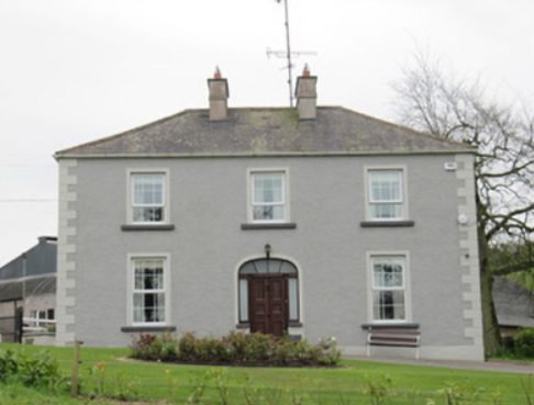
| Rakenny/Rathkenny House | A two storey square block of a house built in the late 1820s for Theophilus Lucas-Clements to the design of William Farrell. According to Bence Jones it was built with money given to Theophilus ‘by his cousin, Harriet, whose father, Captain John Clements, made a considerable fortune commanding a ship in the East India Company service’. A previous Clements home had been located on the other side of the Annalee River, of which the 18th century demesne and tea house survive and a walled garden dating back to 1695. Rakenny is the name of the house on the first edition six inch Ordnance Survey map (publ. 1837) but the house is commonly known as Rathkenny. It had a rateable valuation of £48.5.0. in the mid-19th century. Rathkenny House continued to be the home of the Lucas-Clements family until it was put up for sale in 2012 (Irish Times, 10 May 2012). | |
| Wood Lodge | Wood Lodge was the home of Elizabeth Anne Clements and her husband, the Reverend Edward Lucas, at the end of the 18th century. This house was situated in the Rakenny demesne to the south of the new Rathkenny house built in the 1820s by their son. It is named on the first edition six inch Ordnance Survey map (publ. 1837) when it is shown as a square block of four buildings surrounding a court yard. Valued at £10.5.0. at the time of Griffith’s Valuation, it was occupied by William Armstrong (Lewis records J. Armstrong as proprietor of Woodford, parish of Enniskeen). The building was reduced in size as shown on the 25 inch map. The Lodge is no longer extant. | |
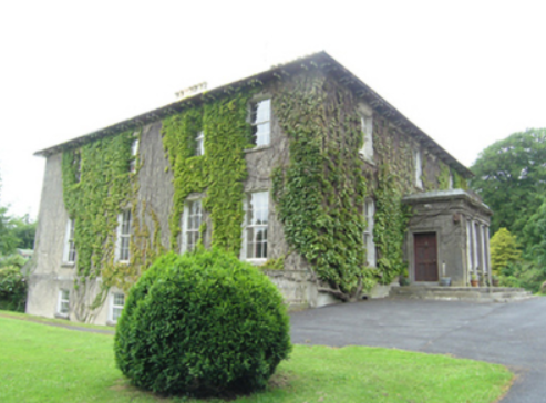
| Ashfield Lodge | Described by Bence Jones as a late Georgian house, now demolished. The house faced north west and looked onto the Dromore River. It was the home of a branch of the Clements family until 1952 when sold. Colonel Henry Theophilus Clements was the occupant in the mid-19th century holding the property in fee. The house was valued at £44 for rates. | |
| Retreat/Faybrook | Retreat, set in a small demesne close to Dromore River with a corn mill nearby, is named on the first edition six inch Ordnance Survey map (publ. 1837). It appears to have been a Bredin home in the early 1850s. By the time of Griffith’s Valuation it belonged to Thomas Fay and was occupied by James Boyle. The rateable valuation was £10. The house reduced in size, or possibly a new structure, was renamed Faybrook. It is marked on the 25 inch map and is still extant. | |
| Drumsheil House | Drumsheil was originally part of the Ashe estate which was sold to the Clements family. It is named on the first edition six inch Ordnance Survey map (publ. 1837) and was situated close to a lough of the same name. The house, with a rateable valuation of £8, was occupied by William Caldwell in the mid-19th century and held from the representatives of Charles Adams. The Caldwell family were still resident in 1911. The site is now a green field. | |
| Tullyvin House | Tullyvin was originally a home of the Moore family. In 1814 the Reverend Benjamin Adams was resident. It was inherited by Maxwell Boyle, who according to the National Inventory of Architectural Heritage rebuilt the house circa 1820. At the time of Griffith’s Valuation the house was vacant but in the possession of Maxwell W. Boyle. It was valued at £30 for rates. In 1876, Tullyvin was the home of Mrs Charlotte Townley, the owner of over 2,000 acres in the county. The house had a rateable valuation of £30.10.0. in 1906 and Maxwell J. Boyle was recorded as the occupier. This house is still a fine residence. |
|