Clontoe
Houses within 10km of this house
Displaying 48 houses.
Houses within 10km of Clontoe
Displaying 48 houses.
| House name | Description | |
|---|---|---|
| Carrachor | Carrachor House is named on the 1st edition 6 inch Ordnance Survey map (1836) and Lewis records J. Wright as the proprietor. It was later expanded and by the mid-19th century was held by Joseph C. Wright in fee. The buildings were valued at £16. In the early 20th century Joseph Mitchell and his wife Elizabeth were resident. Joseph Mitchell may have been a relative of the Wrights. The house is still extant. | |
| Gola | Built in 1703 by Joseph Wright son of James Wright and his second wife Mary Slacke (www.thesilverbowl.com). It was the home of the Wright later Woodwright family in the 18th and 19th centuries. At the time of Griffith’s Valuation the Reverend William E. H. Woodwright was resident. The buildings were valued at £25. In 1901, Patrick Callaghan, steward, was resident in Gola. Sir John Banks (1815-1908) was the proprietor. He was a well-known Dublin physican who had married in 1848 Alice Woodwright. Their only child Mary married Willoughby Burrell 4th Baron Gwydyr in 1873. On 25 February 1921 Gola was burnt and subsequently demolished. | |
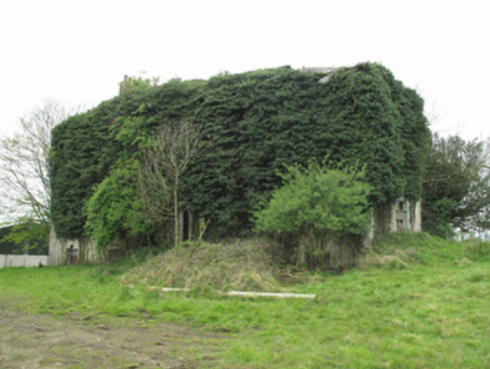
| Brandrum | An early 18th century house located on the Cole of Florence Court estate. Early residents were Edward Mayne of the Mount Sedborough family and the Reverend Robert Montgomery, whose mother was a Cole. The house was close to another 18th century Montgomery home Ballyleck. It is named on the 1st edition 6 inch Ordnance Survey Map (1836). The Ordnance Survey Field Name Book states that ‘Brandrim is a delightful residence, there is an excellent house with good offices and gardens attached; the grounds well laid out and well planted’. Lewis records Owen Blayney Cole as the proprietor and he was leasing the property to Thomas Coote at the time of Griffith’s Valuation. The buildings were valued at £35. Brandrum was the home of Hugh Gill Patterson and family in the early 20th century. This house is now a ruin. |
|
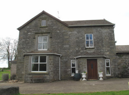
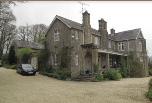
| Bessmount Park | The original house ‘Bessmont’, sometimes spelt Bessmount, dates from the early 1800s and is marked and named on the 1st edition 6 inch Ordnance Survey map (1836) with a walled garden to the south. It was the home of a branch of the Montgomery family and was inherited through marriage by the Nixons. In the 1830s it was the residence of A. Nixon Montgomery. In 1840 it was acquired by John Hatchell, High Sheriff of Monaghan in 1843 and his daughter held the house in fee circa 1860. The buildings were valued at £46. The house was elaborately re-modelled in an ornate style possibly to the design of an unknown architect in the late 1860s for the owner William Henderson and became known as Bessmount Park. William Henderson was married to John Hatchell’s daughter Frances Maria Isabella. Mrs Henderson, described as a widow, was living in the house in 1901 and a retired doctor Edward Taylor in 1911. This house continues to be a fine residence. |

|
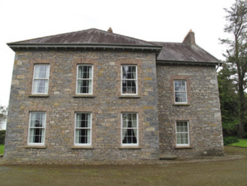
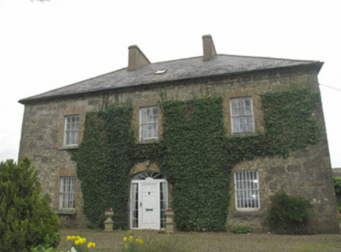
| Ballyleck | Alexander Montgomery, Member of Parliament for county Tyrone, had this house built in the mid-18th century. By the early 19th century Ballyleck had become part of the estate of the Westenra family, Barons Rossmore. The house is named on the 1st edition 6 inch Ordnance Survey Map (1836). Lewis records the Honourable Richard Westenra as resident. He died in 1838. Circa 1860 William M’Keane was the occupier holding the property from Henrietta Westenra. It was valued at £36. A few years later it had become the home of Jesse Lloyd , a brother of Lady Rossmore. This house with extensive outbuildings was the home of Lucius O’Brien and family in 1901 and of William Black and family in 1911. This house is still extant. |

|
| Poplar Vale | Home of the Richardson family in the 18th and 19th centuries, Lewis records Major E. Richardson as proprietor. The house is named on the 1st edition 6 inch Ordnance Survey map (1836) surrounded by parkland and an extensive walled garden. The buildings were valued at £30 circa 1860 when John Richardson was the occupier holding the property from Robert Ellis. Edward John Richardson was resident in the early 20th century. In the 1940s St Patrick’s Agricultural College was established at Poplar Vale. | |
| Beech Hill | Located on the outskirts of Monaghan town, Beech Hill is named on the 1st edition 6 inch Ordnance Survey Map (1836). The buildings at Beech Hill were valued at £40 in the mid-19th century. William Murray was the occupant. He held the property from Lord Rossmore. Sarah Ker, eldest daughter of André Allen Ker, is described in Burke’s Landed Gentry of Ireland (1904) as resident here. In 1880 she married Fitzjohn Robert Irwin of Kilkeel, county Down. Beech Hill College, a secondary school, is now located on this site. | |
| Cornecassa | This house was the home of the Hamilton family from the early 19th century built by Dacre Hamilton. Lewis records it as the home of Dacre Hamilton, son of Sir James, who was agent for the Rossmore, Castleshane and Templeton estates. Cornakessagh House is named on the 1st edition 6 inch Ordnance Survey map (1836). At the time it had extensive laid out gardens and some plantations. James Hamilton was the occupant at the time of Griffith’s Valuation, circa 1860. He held the property from Lord Rossmore. It was valued at £120. The library was sold in 1922 following the death of Captain Hamilton. The main part of the house was demolished in 1934. The service wing survives as does the farmyard complex. See http://archiseek.com/2016/cornacassa-house-monaghan-co-monaghan/ | |
| Clonamully | This house, sometimes spelt Clenamully, was the home of the Fiddes family in the 19th century. Members of the Fiddes family were land agents. Located on the Lewis, formerly Scott estate, it was named on the 1st edition 6 inch Ordnance Survey map (1836) and had a walled garden. The Reverend James Fiddes was rector of the parish of Drumsnat. Edward Fiddes who inhabited the house in the 1830s and at the time of Griffith’s Valuation was the Reverend James’ son and agent to the Rose estate. Edward died in 1868, aged 78, and was buried in Drumsnat graveyard. In 1901, Joseph Fiddes, land agent, was the occupier and in 1911 four of his children were living in the house. The original house has had additions and alterations. |
|
| Raconnell | Raconnell belonged to the Owen family in the 18th century. The will of Nicholas Owen of Raconnell is dated 1 May 1759. Possession of this townland passed to the Lucas and Cole families through marriage. It is named on the 1st edition 6 inch Ordnance Survey map (1836) with a substantial yard and walled garden to the rear. Occupied by Colonel R. Lucas in the 1830s. Edward William Lucas lived here at the time of Griffith’s Valuation when the buildings were valued at £24. By the mid-1870s Thomas Coote was occupying Raconnell. Raconnell House is still extant but unoccupied. |

|
| Newgrove | This locality was in the possession of Blayney Owen described as ‘of Newgrove’ in the early 18th century. In the 1830s, Lewis records M. Hawkshaw as resident at Newgrove, located on the Lucas estate. By the early 1860s Thomas C. Sterne was the occupier when the buildings were valued at £8.10.0. Home of the Wilson family in the early 20th century. | |
| Anketell Grove/Trough Lodge | Bence Jones writes that the Anketells have built three houses in this area but on different sites. The first house was constructed in the mid-17th century. The second one was built by Oliver Anketell and demolished in 1781. The third house was built in the 1780s and was remodelled in the mid-19th century. Andrew Crawford appears to have lived here in 1807 and James Mervyn B[unbury] Richardson between 1812 and 1827 (see Richardson Papers 1197 in the National Archives). On the 1st Ordnance Survey 6 inch map (1836) it is marked as Trough Lodge. It later became known as Anketell Grove. The Ordnance Survey Field Name Book describes Trough Lodge as ‘a very handsome house and has good office houses’. At the time of Griffith’s Valuation the buildings were valued at £50 and were held by Matthew J. Anketell in fee. In 1901, Samuel Griffen, land steward, and family were the occupants. Patrick McKenna bought Anketell Grove and 130 acres in 1928. |

|
| Dungillick House | Dungillick House, the home of a branch of the Anketell family from at least the mid-18th century, is named on the 1st edition 6 inch Ordnance Survey Map (1836). The Ordnance Survey Field Name Book records the house as thatched. In the mid-19th century Matthew J. Anketell was recorded as the occupant. He held the property from Lord Cremorne. The buildings were valued at £20. Occupied by the Burgess family at the beginning of the 20th century. Dungillick was bought by the Land Commission in 1932 and the house was purchased by James McKenna in 1935. This house remains a family residence. |

|
| Fort Johnston | The Johnstons were in possession of Stramore from about the mid-18th century and Fort Johnston appears to have been in existence from then. This long house is named on the 1st edition 6 inch Ordnance Survey map (1836). The Ordnance Survey Field Name Book describes Lieutenant Johnson’s house as ‘a pretty good house (cottage built)’ called Fort Johnson. On the 25 inch map (surveyed 1908) it appears as a square block so it may have been altered. In the mid-19th century it was the home of Henry G. Johnston held by him in fee. Burke’s ‘Landed Gentry of Ireland’ (1904) records Fort Johston as the family seat but their residence was in Bandon, county Cork |
|
| Liscarney House | The home of the Ross family for at least a century and a half. David Ross of Liscarney is mentioned in a deed of 1816. Major Ross is recorded in Liscarney in the Tithe Applotment Book and also by Lewis in the 1830s. In Griffith’s Valuation (circa 1860) James Ross (1819-1893) is mentioned as the occupier holding the property in fee. The buildings were valued at £32. Members of the Ross family continued to reside here well into the 20th century as The Irish Law Times and Solicitors Journal of 1955 records the death of Sharman Crawford Ross, solicitor and estate agent, of Liscarney. |
|
| Faulkland Castle | Shirley refers to the confinement of John Leslie, Dean of Dromore, by Robert Maxwell, Sheriff of Monaghan, in his house at Falkland/Faulkland in 1707. The Maxwells occupied Faulkland Castle until 1780. By the time of Griffith’s Valuation it was valued at £1.6 shillings and was held by James Jackson Senior from the trustees of John Maxwell. The 25 inch map (surveyed 1908) shows the castle ‘in ruins’. | |
| Mullaghmore | This was the home of James Rose and after his death in 1841 of his niece Gertrude. It was described by Lewis in the 1830s as ‘greatly improved and extensively planted’. The buildings were valued at £38 at the time of Griffith’s Valuation circa 1860 but the house was unoccupied at the time. Gertrude Rose was, however, resident in 1901. Home of Sir Robert Anderson, Mayor of Belfast 1908, for a few years; his widow was living at Mullaghmore in 1911. The house was later the home of a Captain Taft and was destroyed by a fire in 1925 (New Zealand Tablet, 8 April 1925, 47). |
|
| Slacksgrove/Hollywood House | Slacksgrove is marked as a long building close to the shore of Slacksgrove Lake on the 1st edition 6 inch Ordnance Survey map (1836). It was named after the family who lived there in the 18th century. John Slack of Slacksgrove was High Sheriff of county Monaghan in 1758. Lewis records R. Jackson as resident at Slacke’s Grove in the 1830s. A later square house on the same site, known as Hollywood House, was built before Griffith’s Valuation of the mid-19th century. This house with an extensive farmyard was valued at £36. It was occupied by James Fiddes who held the property from Thomas Coote. Edward Fiddes and his daughter lived in the house in the early 20th century. Only the outbuildings of Hollywood House still remain. | |
| Mont Louise | Home of the Evatt family in the 19th century, R. Evatt was resident in the 1830s. Samuel Evatt was the occupier circa 1860. He held the property in fee and the buildings were valued at £9. Home of George F. Evatt at the beginning of the 20th century. A building is still located at this site. | |
| Drumreask | Built circa 1840 for Alexander Mitchell, agent to the Shirley estate. This house was the home of the Mitchell family until sold in 1864 to the Kane family. It is named on the 1st edition 6 inch Ordnance Survey map (1836) with an extensive walled garden at the rear. Griffith’s Valuation records the value of the buildings at £25 held by Henry Mitchell in fee. It was still in the ownership of the Kane family in the early 20th century. The house was derelict in the early 21st century. It was purchased by millionaire Gerry McCaughey with a view to turning it into a hotel and equestrian centre (Irish Independent, 25 May 2008) but this does not seem to have come to fruition. |

|
| Drummaconor | A building is marked at this site on the 1st edition 6 inch Ordnance Survey Map (1836) and named on the 25 inch map (surveyed in 1908). In the mid-19th century the house was occupied by John Fawcett who held the property in fee. The buildings were valued at £12. It was at a Halloween ball in this house in 1871 that the dresses of two daughters of Sir William Wilde caught fire causing their deaths a few days later. The ball was hosted by a local bank manager Mr Reid. James Treanor and his family were resident in the early 20th century. He was a farmer and local magistrate. This house is still extant and has functioned as a guest house. For photo circa 1905, see https://madaboutmonaghan.ie/kilmore-and-drumsnatt | |
| Coolmain House | The National Inventory of Architectural Heritage dates this house to circa 1790. It belonged to a family called Graham in the 18th century according to a story recorded in the Schools Collection under Coolmain House. It was named on the 1st edition 6 inch Ordnance Survey Map (1836). In the 19th century this property belonged to the Brooke family of Dromavana, county Cavan. Burke’s Landed Gentry of Ireland 1904 records William Brooke of Dromavana, Dublin and Coolmaine House. He was born in 1769 and married Angel daughter of Captain Edward Perry and niece and heiress of Colonel Richard Graham. John Goudy of Coolmain House is listed in Lewis’ ‘Topographical Dictionary’ published 1837 for the parish of Tehallan but his name is spelt Gondy in the list of subscribers. John Goudy is recorded in Griffith’s Valuation as resident holding the property from the Reverend Edward P. Brooke and others. James Gondy Lewers of Coolmain House died in November 1885 (The Northern Standard, 7 November 1885). This house was occupied by James H. Pollock in 1911 and is still a residence. | |
| Camla | Described by Bence Jones as a late Georgian house of one storey over a high basement, situated close to Rossmore Park. Lewis records Lieutenant Colonel Henry Westenra as resident. He left the property to his nephew the 3rd Baron Rossmore. At the time of Griffith’s Valuation occupied by Jesse Lloyd, Lord Rossmore’s brother-in-law, who soon moved to another Rossmore property nearby, Ballyleck House. The buildings were valued at £85 and a steward’s house was also located in this townland. By 1906, the buildings at Camla were valued at £55 with 118 acres of untenanted land. Occupied by James Pollock, land steward in 1901 and Fred Millard, estate agent, in 1911. Camla became the home of the 6th Lord Rossmore after World War II. It was sold in 1962. The building has been demolished and the site is now a green field. | |
| Selloo | A building at this site is marked on the 1st edition Ordnance Survey map (1836) and named on the 25 inch map. In 1853 Selloo described as a 'convenient residence, placed in an ornamentally planted demesne, and also a corn mill, kiln etc' was advertised for sale in the Encumbered Estates Court by Joseph Whitsitt. This was the home of the Pringle family in the mid-19th century, valued at £18 and held in fee by William Pringle. The Hunter and Deering families occupied the house in 1901 and 1911 while Thomas A. Pringle was the landholder. It appears to be currently extant. | |
| Tully House | An early two storey 19th century house, marked on the 1st edition 6 inch Ordnance Survey map (1836) with a later extension. This was the home of the Hall family located on the outskirts of Monaghan town. Pery Hall of Tully House was the father of the Reverend Richard Augustus Hall who married Mary Henry of Mourne Abbey, county Down in 1849. At the time of Griffith’s Valuation the house was valued at £14 and occupied by John S. Stuart. Mary, widow of the Reverend Hall, was the occupant in the early 20th century. This house continues to be a residence. The Halls also had a house in the town of Monaghan, townland of Mullaghmonaghan, close to the County Infirmary known as Rowantree. |

|
| Portinaghy House | Buildings are located at this site on the 1st edition 6 inch Ordnance Survey map (1836). In the mid-19th century the house was valued at £18 and inhabited by Mary Campbell, who held the property from Charles P. Leslie. In 1876, the representatives of Mrs Mary Campbell, Portinaghy, owned 211 acres in county Monaghan. Home of the Edwards family in the 20th century. |
|
| Hollow House | Marked on the 1st edition 6 inch Ordnance Survey map (1836), this house was extended and by the mid-19th century was valued at £12. It was occupied by James Cargill and was situated on the Leslie estate. In 1901, Samuel Cargill, a miller and farmer, was resident with his family. |
|
| Broomfield Cottage | This house was located on the Leslie estate and dates from about the mid-19th century. At the time of Griffith’s Valuation it was occupied by George Scott and its buildings were valued at £12. Home of the McKenna family at the beginning of the 20th century. |
|
| Cappog House | A house built in the mid-19th century, valued at £10 circa 1860 and occupied by Richard Blakely and held from Henry Mitchell. In the early 20th century home of Ernest Henry Greene, a distinguished Irish tennis player & his wife Georgiana, a painter. This house appears to be still extant. | |
| Lisdoogan | A small building marked at this site on the 1st edition 6 inch Ordnance Survey map (1836). It was valued at £8 in the mid-19th century and John Stephenson was the occupier holding the property from Henry Mitchell. The building was enlarged at about this time and again circa 1900 to create the substantial building of today. James Mitchell, formerly Clerk of the Union, and his family were resident at the beginning of the 20th century. |

|
| Blackwater Vale | This house is marked on the 1st edition 6 inch Ordnance Survey map (1836) and located just outside the town of Monaghan. The building was expanded in the mid-19th century. Griffith’s Valuation records the buildings valued at £13 when the house was occupied by Thomas E. Wright who held the property from William and Charles Crofton. At the beginning of the 20th century Blackwater Vale was occupied by Foster Dunwoody, a solicitor. Still extant and occupied. |
|
| Kilcorran House | This 18th century house has a date stone over the door 1756. In the mid-19th century it was the residence of William Beatty held in fee. Kilcorran remained the home of the Beatty family until at least the mid-1940s when Rowland Beatty/Betty died there. |
|
| Aghnamallagh House | James A. Mayne lived in this house in the mid-19th century. He held it in fee and the buildings were valued at £22. This was the home of the Elliot family in the early 20th century. The house is still extant. see https://www.geograph.ie/photo/897268 | |
| Thornhill (Drumsnat) | John Johnston is described in the Ordnance Survey Field Name Book as the only gentleman resident in the parish. He lived at Thornhill. On 13 June June 1854, this house and a demesne of about 40 acres was for sale in the Encumbered Estates Court. The owners and petitioners were Mary Johnson, widow, Maria and Jane Johnson and Martha Dudgeon, formerly Johnson. The property was held under a lease (1738) for 999 years. By the time of Griffith’s Valuation Robert Thomson was the occupant holding the property from Owen B. Cole & Olivia Lucas. The buildings were valued at £25. Home of Felix P. Smith and family in 1911. |

|
| Mullynahinch House | The National Inventory of Architectural Heritage dates this house circa 1860. Griffith’s Valuation gave a valuation of £12 for the buildings. John C. M’Adams was resident holding the property from Charles Hopes. Bachelor members of the Temple family lived here in the early 20th century. | |
| Rosefield | A house built in the early 18th century close to Rosefield Lake, it was the home of the Rose family and by the 1760s of Thomas Tenison and later of Alexander Montgomery. By the early 19th century Ralph Dudgeon was the occupant. He is recorded in the Tithe Applotment Book and in Lewis’ Topographical Dictionary. Valued at £16 and the residence of Samuel Mitchell held from the trustees of Captain Slake [Slack] circa 1860. Home of Henry Mitchell and his siblings in the early 20th century. | |
| Dromore House | Dromore House is named on the 1st edition 6 inch Ordnance Survey map (1836) with a circular drive to the front and a walled garden to the rear. It was the home of C. Hawkshaw in the 1830s. Located on the Hatchell estate it was occupied by James Wade at the time of Griffith’s Valuation and valued at £14. The home of the Smyth family in the early 20th century, this house is no longer in existence. | |
| Sallymount | Sallymount facing a plantation is named on the 1st edition 6 inch Ordnance Survey map (1836). In the 1830s it was the home of T. Robinson. At the time of Griffith’s Valuation the buildings were valued at £8 and John Woods was the occupant, holding the property from John Maxwell, whose estate was at that time being administered by the Court of Chancery. Home of the Assistant County Surveyor James Smith in 1911. He held the house from John McMahon. A building is still located at this site. | |
| Rossmore Park | Situated on an elevated site the original house was known as Cortolvin Hills. This is the name that appears on the 1st edition 6 inch Ordnance Survey map (1836) for the house. It was the home of the Westenra family, Barons Rossmore. In 1824, Richard Morrison produced plans to rebuild the house and by the end of the decade William Morrison had taken over from his father. Collins writes that the old house appears to have become the servants’ wing and that the new house had a Jacobean facade. Lewis refers to Rossmore Park as ‘a handsome mansion in the Elizabethan style’. It was remodelled in the late 1850s to the design of W.H. Lynn, after which, Bence Jones writes, ‘the combined ranges boasted of at least 117 windows, of 53 different shapes and sizes’. The buildings were valued at £250 in Griffith’s Valuation and in 1906. During World War II the 6th Lord Rossmore moved from Rossmore Park to Camla House due to pervasive dry rot in the house. It was unroofed after the war and the ruin was demolished in the mid-1970s. | |
| Will Ville | The National Inventory of Architectural Heritage dates this building early 18th century. It was located on the estate of Lord Rossmore and is named on the 1st edition 6 inch Ordnance Survey map (1836). Valued at £10 and occupied by Robert Wilson at the time of Griffith’s Valuation. Still occupied by Robert Wilson, farmer, in the early 20th century. This house has been unoccupied for some time. |
|
| Cortolvin | This house was built between the first Ordnance Survey of the 1830s and the surveying for Griffith’s Valuation in the 1850s. It is marked on the 25 inch map (surveyed 1908) and named Cortolvin. In Griffith’s Valuation it was occupied by William A. Hunter and held from Lord Rossmore. It was valued at £16. This house is still extant. | |
| Tirkeenan House | This house is named on the 1st edition 6 inch Ordnance Survey map (1836). It was located on the Rossmore estate and very close to the town of Monaghan. It was occupied by John M’Dowell circa 1860 when the buildings were valued at £32. A third storey was added to this house in the 20th century. |

|
| Corlat House | A house named Cook Mount was located in Corlat on the first Ordnance Survey Map (circa 1836). Corlat House was built in the mid-19th century on a nearby site, valued at £20 and occupied by the Reverend James Bleakley, who held it from William Murray. In the early 20th century William McWilliam, Clerk of the Crown and Peace lived at Corlat House. It is no longer extant. | |
| Gallanagh House | Gallanagh House, located just north west of Monaghan town, is named on the 1st edition 6 inch Ordnance Survey map (1836). At the time of Griffith’s Valuation circa 1860 it was occupied by William Watson and held from James Hamilton of Cornacassa. The buildings were valued at £36. This house appears to have been unoccupied in 1901 and the home of Ernest P. Tyacke, County Inspector Royal Irish Constabulary, in 1911. Tyacke held the property from William Swan. A William Swan was proprietor of the newspaper ‘The Northern Standard’, Monaghan. A large complex of buildings [poultry factory] now occupies the site. | |
| Loughoony | An elongated building facing the lake of the same name and marked on the 1st edition Ordnance Survey map (1836). The National Inventory of Architectural Heritage dates this house to circa 1790 and describes it as having a multiple-bay two-storey return. The Ordnance Survey Field Name Book records it as a good dwelling house the residence of Mrs Murray, widow of a Counsellor who was drowned in the lake nearby. In the mid-19th century the buildings were valued at £20 and the house was inhabited by Andrew Clarke who held it from William Ritchie. Loughoony was the home of Samuel Condell and family at the beginning of the 20th century |
|
| Tullaghan | The ruins of Tullaghan House are marked on the 1st edition 6 inch Ordnance Survey map (1836). It was located on the estate of Lord Rossmore. Lewis writes in the 1830s that Tullaghan belonged to the Reverend Sir Thomas Forster Bart. ‘whose family formally resided here’. By the time of Griffith’s Valuation a herd’s house had been erected close by. It is named Tullaghan House on the 25 inch map (surveyed 1908). | |
| Carrowbarra House | In 1798 ‘Carrowbarragh’ was associated with William Campbell an attorney-at-law who immigrated to Canada. In the 1830s Lewis records Carrowbarrow as the home of the Reverend Michael Fox Dudgeon who married Mary Moore of Moore Fort, Ballymoney, Co Antrim. Later he was vicar of Cratfield, Surrey. Henry Dudgeon occupied a house valued at £1.10.0. in Carrowbarra Island at the time of Griffith’s Valuation. He held the property from Owen B. Cole and Olivia Lucas. Owen B. Cole and Olivia Lucas were the lessor of the townlands of Carrowbarra and Carrowbarra Island. Mary Johnston occupied a house valued at £6 in Carrowbarra townland in the 1850s. A substantial house named Carrowbarra House is marked on the 25 inch map in Carrowbarra Island. | |
| Riversdale (Tedavnet) | This house is marked on the 1st edition 6 inch Ordnance Survey map (1836) and on the 25 inch map (surveyed 1908) it is named. It was located on the outskirts of the village of Bellanode, close to the River Blackwater and to a number of mills. Occupied by Thomas Wright in the mid-19th century and held from Henry Mitchell, the buildings were valued at £6.10.0. A building is still extant at this site. |