Kiltybegs
Houses within 5km of this house
Displaying 9 houses.
Houses within 5km of Kiltybegs
Displaying 9 houses.
| House name | Description | |
|---|---|---|
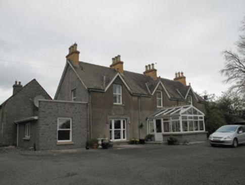
| Fort Johnston | The Johnstons were in possession of Stramore from about the mid-18th century and Fort Johnston appears to have been in existence from then. This long house is named on the 1st edition 6 inch Ordnance Survey map (1836). The Ordnance Survey Field Name Book describes Lieutenant Johnson’s house as ‘a pretty good house (cottage built)’ called Fort Johnson. On the 25 inch map (surveyed 1908) it appears as a square block so it may have been altered. In the mid-19th century it was the home of Henry G. Johnston held by him in fee. Burke’s ‘Landed Gentry of Ireland’ (1904) records Fort Johston as the family seat but their residence was in Bandon, county Cork |
|
| Lough Emy | Lough Emy house on the Leslie estate was built in the mid-19th century. At the time of Griffith’s Valuation it was occupied by William V. Ryan and valued at £20. It retained this valuation in 1906. The 25 inch map (surveyed 1908) shows the house at the end of a long tree lined avenue with Emy corn mill close to the entrance. It was the home of the Kavanagh/Cavanagh family in the early decades of the 20th century. This house is completely demolished, the site is now a green area. | |
| Portinaghy House | Buildings are located at this site on the 1st edition 6 inch Ordnance Survey map (1836). In the mid-19th century the house was valued at £18 and inhabited by Mary Campbell, who held the property from Charles P. Leslie. In 1876, the representatives of Mrs Mary Campbell, Portinaghy, owned 211 acres in county Monaghan. Home of the Edwards family in the 20th century. |
|
| Hollow House | Marked on the 1st edition 6 inch Ordnance Survey map (1836), this house was extended and by the mid-19th century was valued at £12. It was occupied by James Cargill and was situated on the Leslie estate. In 1901, Samuel Cargill, a miller and farmer, was resident with his family. |
|
| Broomfield Cottage | This house was located on the Leslie estate and dates from about the mid-19th century. At the time of Griffith’s Valuation it was occupied by George Scott and its buildings were valued at £12. Home of the McKenna family at the beginning of the 20th century. |
|
| Leek House | An early 19th century house on the Leslie estate, marked on the 1st edition 6 inch Ordnance Survey map (1836). Occupied by William Cochran at the time of Griffith’s Valuation and with a rateable valuation of £20. Occupied by Samuel Barbour and family at the beginning of the 20th century. |
|
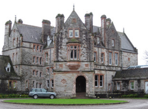
| Castle Leslie | The area around Glaslough was part of the MacMahon territory granted to Sir Thomas Ridgeway in 1608, who built a castle on his newly acquired lands. In 1665, Glaslough was bought from the Ridgeway trustees by Bishop Leslie and the castle became the home of the Leslie family. By the 1830s, Castle Leslie ‘situated about 6 chains to the north of the town of Glasslough’ was described as ‘a poor building and in a dilapidated state’. The present house, a Victorian edifice, sometimes known as Glaslough House, is described in the National Inventory of Architectural Heritage as ‘undoubtedly the finest country house in County Monaghan’. It was built for John Leslie in the 1870s to the design of Sir Charles Lanyon and William Henry Lynn. Located close to the site of the original Castle Leslie which it would appear from Shirley’s ‘History of the County of Monaghan’ was still extant in 1877 (page 147, includes drawing) but was demolished soon afterwards. In the mid-19th century the building was valued at £55 and held by Charles P. Leslie in fee. A caretaker’s house and farm buildings valued at £60 were located in the townland of Kiltybegs to the north east. By 1906, the rateable valuation of this mansion was £300. It was occupied by a butler and other servants in 1901 and by Sir John Leslie in 1911. Castle Leslie now functions as a hotel run by Sammy Leslie, see https://www.castleleslie.com/ |
|
| Annagola | This house, situated very close to the border with county Armagh, is marked on the 1st edition 6 inch Ordnance Survey map (1836) and named on the 25 inch map (surveyed 1908). The building had been extended. William George Irwin lived at Annagola in the 1840s. In the mid-19th century the buildings were valued at £35 and held by Maria Irwin from the trustees of Dr Sterne’s charities. Occupied by Robert Quinn, gardener, and his family at the beginning of the 20th century. |
|
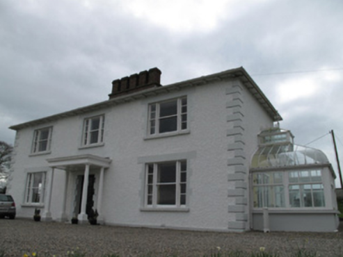
| Annareagh House | Built in the mid-19th century, valued at £16 and held by William Martin from the trustees of Dr Sterne Charities. Named on the 25 inch map (surveyed 1908) as Annarea House with a square block of outbuildings behind the house. |