Raymoghy
Houses within 15km of this house
Displaying 64 houses.
Houses within 15km of Raymoghy
Displaying 64 houses.
| House name | Description | |
|---|---|---|
| Blanket Nook | Messers Brassey and McCormack held this property in fee at the time of Griffiths Valuation in the 1850s when it was valued at £13. It is described as a steward’s house. The National Inventory of Architectural Heritage dates its building to the mid -1840s, contemporary with the massive reclamation of land from the sea which took place in the area at that time. Blanket Nook is still extant. |
|
| Ballymoney (Burt) | At the time of Griffiths Valuation in the 1850s, Samuel Porter was leasing this property from Lord Templemore’s estate when it was valued at £11. It is labelled Ballymoney on all editions of the Ordnance Survey maps but is no longer extant. | |
| Bohullion | Several properties at this location were being leased from Lord Templemore’s estate by members of the Leathem family at the time of Griffith’s Valuation, in the 1850s. Samuel Leathem senor occupied a house which was valued at £14 10s. Samuel Leathem junior occupied a house and substantial mill and distillery complex. The National Inventory of Architectural Heritage indicates that the house at the site is now called Beech Park and dates from c.1845. Elements of the industrial complex are also still extant. | |
| Bridgetown (Burt) | At the time of Griffiths Valuation in the 1850s, John Scott was leasing this property from Lord Templemore’s estate when it was valued at £23 with an additional mill complex. Bridgetown is still extant and occupied. | |
| Ballyarr House | Lord George Hill was leasing this property from Mrs. Brooke at the time of Griffith’s Valuation, when it was valued at £35. He resided there until his death in 1879. Ballyarr is still extant. | |
| Rathdonnell House | James Hamilton was leasing this property from the estate of Reverend William Alexander at the time of Griffiths Valuation in the 1850s when it was valued at £7. Local sources suggest it had come into the Alexander family through their mother, Dorothy McClintock. | |
| Fort Stewart (KIlmacrenan) | Sir James Stewart was leasing this property from the estate of Thomas Brooke at the time of Griffiths Valuation in the 1850s, when it was valued at £50. In 1837 Lewis also noted it as the seat of Sir J. Stewart. Buildings are still extant at the site. | |
| The Lodge (Bridgend) | Anne Scott was leasing this property from the Stewart estate at the time of Griffiths Valuation in the 1850s, when it was valued at almost £15. The property is labelled "The Cottage" on the 1st edition Ordnance Survey map but as "The Lodge" on the 25-inch map of the early twentieth century. It is still extant. |
|
| The Green | At the time of Griffiths Valuation in the 1850s James Watt was leasing this property from the Stewart estate when it was valued at £50 and included a mill. It is still extant. |

|
| Glencarn (Rathmelton) | John Fullerton was leasing this property from the Stewart estate at the time of Griffiths Valuation in the 1850s, when it was valued at £17. It is labelled Glencarn on all editions of the Ordnance Survey maps. A house is still extant at the site. John Fullerton's address in the 1870s Landowners Survey is recorded as "The Cairn", Rathmelton. | |
| Gortlee | Thomas Patterson was leasing Gortlee from the Wray estate at the time of Griffiths Valuation in the 1850s, when it was valued at £25. The National inventory of Architectureal Heritage suggests it was built in the late 18th century but may have subsequently been modified on a number of occasions. It is also associated with the Boyd family. In 1837 Lewis had noted it as the seat of J. Cochran. Gorlee is still extant and occupied. |
|
| Castlewray | The Wray family were associated with this locality since the seventeenth century. Local sources suggest that Castlewray was sold by the Wrays to the Mansfield family around 1800. At the time of Griffiths Valuation in the 1850s, it was occupied by Margaret Mansfield, leasing from Francis Mansfield and valued at £16. It is now a ruin. | |
| Greenhills (Raphoe) | William Fenwick held this property in fee at the time of Griffiths Valuation in the 1850s, when it was valued at £55. The National Inventory of Architectural Heritage suggests that it dates from the later eighteenth century though altered in the 1870s. It was originally associated with the Nesbit family into which William Fenwick married. In 1906 it was owned by Philip and Charles Fenwick and valued at £27. The house is still extant though not in good repair. |
|
| Tully Hall (Kilmacrenan) | James Watt held this property in fee at the time of Griffiths Valuation in the 1850s. It was valued at £30 and included a flax mill. | |
| Claragh (Kilmacrenan) | James Watt was leasing this property from the estate of the Ecclesiastical Commissioners at the time of Griffiths Valuation in the 1850s, when it was valued at £28. By 1906 it was also owned by James Watt with a valuation of £66. The current house on the site was constructed in the late Victorian period. It was refurbished in recent years and in 2026 was offered for sale. |
|
| Newmills | Matthew Nelson was leasing this property from the Macky estate at the time of Griffiths Valuation in the 1850s, when it was valued at £33 and included a milling complex. | |
| Guystown (Raphoe) | At the time of Griffiths Valuation in the 1850s, Benjamin Humfrey was leasing this property from the Erne estate, when it was valued at £7. It was subsequently enlarged and is labelled Guystown on all editions of the Ordnance Survey map. The National Inventory of Architectural Heritage suggests it was originally built c.1720. It is still extant and occupied. | |
| Dromore (Raphoe North) | At the time of Griffiths Valuation in the 1850s, Jane Stephenson was leasing this property from the Earl of Erne's estate when it was valued at £10. | |
| Toberoneill | At the time of Griffiths Valuation in the 1850s, Joseph Henderson was leasing this property from the Earl of Erne's estate when it was valued at £12. The National Inventory of Architectural Heritage suggests the large scale outbuildings date from c.1860. There is an altered house at the site. |
|
| Shannon Middle | James Henderson was leasing this property from the Earl of Erne's estate at the time of Griffiths Valuation in the 1850s, when it was valued at £11. It is labelled Shannon Middle on all editions of the Ordnance Survey maps. Substantial farm buildings exist at the site now. | |
| Shannon (Raphoe North) | Samuel Gourley was leasing this property from the Erne estate at the time of Griffiths Valuation, when it was valued at £10. It is labelled Shannon on all editions of the Ordnance Survey maps. A farm is extant at the site. | |
| Cavanacor | This property was held in fee by Benjamin [Humfrey] at the time of Griffiths Valuation, when it was valued at £33. Wilson referred to it as the seat of "Mrs Kays" in 1786. The National Inventory of Architectural Heritage suggests it was built about 177-, possibly incorporating part of a seventeenth century house. It is still extant and occupied. |
|
| Broomfield (Raphoe North) | John Humphreys was leasing this property from Robert Keys at the time of Griffiths Valuation, when it was valued at £20. It is labelled Broomfield on all editions of the Ordnance Survey maps. A house is still extant at this site. A second house, labelled Cumberland Lodge [C310024], is shown in this townland on the 25-inch Ordnance Survey map of the early 20th century. A house is still extant at this site. | |
| Clonleigh (Raphoe North) | Reverend William Knox held this property in fee at the time of Griffiths Valuation in the 1850s when it was valued at £70. In 1906 it was the property of William Knox and valued at £73. It is no longer extant. | |
| Longvale | At the time of Griffiths Valuation in the 1850s Letitia Keys was leasing this property from the Knox estate when it was valued at £14. On the 1st and 25-inch edition Ordnance Survey maps it is labelled Longvale. The National Inventory of Architectural Heritage suggests that this house, now known as Hall Green Farm, mostly dates from the mid eighteenth century though possibly incorporating fabric from the earlier house on the site, reputedly built by Thomas Keyes in the early seventeenth century. |

|
| Port Hall (Raphoe North) | James Clarke was leasing this property from the Dogherty estate at the time of Griffiths Valuation in the 1850s, when it was valued at £35. The National Inventory of Architectural Heritage suggests it was built in the 1740s for John Vaughan and classifies it as a building of national importance. It is still extant and occupied. |
|
| Murlough (Raphoe North) | At the time of Griffiths Valuation in the 1850s, James Houston was leasing this property from the Earl of Erne's estate when it was valued at £10. On the 25-inch edition Ordnance Survey map the house on the site is labelled Manse. The National Inventory of Architectural Heritage suggests it was enlarged in the later nineteenth century, possibly when it came into use as the manse. It is still extant and occupied. |
|
| Treantagh (Raphoe North) | Henry S. Hamilton was leasing this property from the Abercorn estate at the time of Griffiths Valuation in the 1850s, when it was valued at £25. |
|
| Ardvarnock Lower | ||
| Beltany | David Wilson was leasing this property from the Ecclesiastical Commissioners estate at the time of Griffiths Valuation in the 1850s, when it was valued at £17. It is now a ruin. | |
| Oakpark (Kilmacrenan) | In the 1850s William Wray was occupying Oakpark when it was valued at £21. The National Inventory of Architectural Heritage suggests it was built at the end of the 18th or beginning of the 19th centuries. It may have been built by the Wray family after they left Castle Wray. Oakpark is still extant and occupied. |
|
| Horse Hill House/Knockagarran House (Raphoe South) | The Hone estate was leasing this property to the representatives of John Spear at the time of Griffiths Valuation in the 1850s, when it was valued at £15. It is labelled Knockagarran on the 1st edition Ordnance Survey map but as Horse Hill House on the 25-inch edition of the early twentieth century. It is still extant. | |
| Kiltoy Lodge | At the time of Griffiths Valuation in the 1850s William Boyd was leasing this property from the Ecclesiastical Commissioners when it was valued at £22. The building is still extant and apparently in the process of being renovated. | |
| Ballymacool | At the time of Griffiths Valuation, John R. Boyd was leasing this property from the Ecclesiastical Commissioners, when it was valued at £50. In 1837 Lewis had also recorded Ballymacool as the seat of J. Boyd. The National Inventory of Architectural Heritage suggests it was built c.1770 and continued in the ownership of the Boyd family until 1940. It is now a ruin. |
|
| Ardrumman House | Francis Mansfield was leasing this property from Thomas Patterson at the time of Griffiths Valuation in the 1850s, when it was valued at £40. The National Inventory of Architectural Heritage suggests that the house was built c.1840. It is still extant. | |
| Sallaghagrane House | John R. Boyd was leasing this property from Viscount Southwell's estate at the time of Griffiths Valuation in the 1850s, when it was valued at £35. The house at the site now is later, possibly built in the 1870s. |
|
| Pluck | James B. Marshall was leasing this property from the Hayes estate at the time of Griffiths Valuation in the 1850s, when it was valued at £18. It adjoined a mill complex. The site is occupied by modern buildings now. | |
| Lisnenan House | Robert Ramsay junior was leasing property from Robert Ramsay senior at the time of Griffith’s Valuation in the 1850s. It is not labelled on the 1st edition Ordnance Survey map. It is still extant and has been offered for sale in this decade. | |
| Swilly View | Francis Gallagher was leasing this property from the Hayes estate at the time of Griffiths Valuation in the 1850s, when it was valued at almost £13. The house at this site has been named Swilly View since at least the 1s edition Ordnance Survey map of the 1830s. It is still extant. | |
| Lurgy Upper | Samuel McClintock was leasing this property from the Hayes estate at the time of Griffiths Valuation in the 1850s, when it was valued at £20. It adjoined a mill complex. Farm buildings occupy the site now. | |
| Castle Grove (Kilmacrenan) | Castlegrove House, parish of Aghanunshin, barony of Kilmacrenan, was held in fee by James Grove Wood in the 1850s. The National Inventory of Architectural Heritage suggests it was built c.1750 but modified in the nineteenth century. By 1906 it was owned by John W.C. Grove and valued at £40. It is now a luxury country house hotel. |
|
| Rockhill House (Raphoe North) | At the time of Griffiths Valuation in the 1850s, Rockhill was held in fee by John Vandeleur Stewart when it was valued at £55. Local sources suggest the house was acquired by Stewart from the Chambers family in the 1830s. O'Carroll discusses the ownership by the Cooch and Pratt families of the Rockhill estate. In 1814 Leet had recorded Daniel Chambers as the occupant of Rockhill. By 1906 it was owned by Alexander C.H. Stewart and valued at £52. Later in the 20th century it served as a base of the Irish Defence forces. It is now a luxury hotel. |

|
| Altaghaderry | Alexander Maxwell was leasing this property from the estate of Robert McClintock at the time of Griffith’s Valuation, in the 1850s, when it was valued at £10. Modern buildings are visible at the site now. | |
| Castruse House | William Cochrane was leasing this property from Robert Bateson at the time of Griffiths Valuation in the 1860s when it was valued at £12. It is labelled Castruse Huose on the 25-inch map of the early 20th century. In the 1870s John Motherwell's address is given as Castruse. The National Inventory of Architectural Heritage suggests it was built in the last years of the 18th century on the site of an earlier house. It is still extant and occupied. |
|
| Gortinlieve | James Fulton was leasing this property from Robert Bateson at the time of Griffiths Valuation in the 1860s when it was valued at £14. An adjacent building is labelled Bogay Works on the 25-inch and later Ordnance Survey maps. It was apparently a site for the manufacture of agricultural implements. Farm buildings appear to occupy the site now. | |
| Ballyboe House | This property was held in fee by the Bateson estate at the time of Griffiths Valuation in the 1850s when it was valued at £27. It is labelled Ballyboe House on the 25-inch Ordnance Survey map of the early 20th century. It is still extant. | |
| Bogay House (Raphoe North) | Reverend Edward Bowen held this property in freehold at the time of Griffith's Valuation in the 1850s when it was valued at £35. Local sources suggest it was a hunting lodge built by the Abercorn estate. It is still extant and occupied. |
|
| Colehill | Reverend Hugh Norman was leasing this property from the Earl of Wicklow's estate at the time of Griffith's Valuation in the 1850s when it was valued at £12. It is labelled Colehill on the 1st edition map of the 1830s but as Allsaints Rectory on subsequent Ordnance Survey maps. It is still extant. | |
| Crossroads (Raphoe North) | William Lockhart was leasing this property from the Earl of Wicklow's estate at the time of Griffith's Valuation in the 1850s when it was valued at £10. It has the label Crossroads on the 25-inch and later 6-inch edition Ordnance Survey maps. The National Inventory of Architectural Heritage suggests the house at the site was built later in the 19th century but it appears likely that an earlier house existed there. |
|
| Castleforward | John Ferguson was leasing this property from the Earl of Wicklow's estate at the time of Griffith's Valuation in the 1850s when it was valued at £35. In 1837, Lewis had referred to it as the property of the Earl of Wicklow, then occupied by W. Marshall. Though it survived well into the 20th century, Castleforward is now a ruin. | |
| Ballyhasky House | Reverend William Scott was leasing this property from the Earl of Wicklow's estate at the time of Griffith's Valuation in the 1850s when it was valued at £15. It is still extant and occupied. |
|
| Ballyhasky Middle | Patrick Glacken was leasing this property from the Earl of Wicklow's estate at the time of Griffith's Valuation in the 1850s when it was valued at £10. It is still extant and occupied. |
|
| Monglass | Caldwell Motherwell was leasing this property from the Earl of Wicklow's estate at the time of Griffith's Valuation in the 1850s when it was valued at £13. The house at the site now is of late 19th century construction. | |
| Drumbarnet | Samuel Chambers was leasing this property from the Earl of Wicklow's estate at the time of Griffith's Valuation in the 1850s when it was valued at £18. In 1906 it had the same valuation and was owned by William Glenn. It is still extant. The National Inventory of Architectural Heritages suggests that it was extensively altered around 1911 with an extension added to the front at that time. |
|
| Cloon (Raphoe) | Robert McFarlane was leasing this property from Anne Law at the time of Griffiths Valuation in the 1850s, when it was valued at £16. Labelled as Cloon on all editions of the Ordnance Survey maps. Farm building occupy the site of the original house now. | |
| Moyle Moss | Henry Thompson was leasing this property from John S. Law at the time of Griffiths Valuation in the 1850s, when it was valued at £11. Labelled Moyle Moss on all editions of Ordnance Survey. The National Inventory of Architectural Heritage suggests the house at the site now is not the original but outbuildings date from the mid 19th century. |
|
| Heath Hill (Raphoe) | Francis Long was leasing this property from John S. Law at the time of Griffiths Valuation in the 1850s, when it was valued at £16. A house labelled Heath Hill is visible at this site on the 25-inch Ordnance Survey map of the early 20th century. Buildings are still extant at the site. | |
| Castle (Newtowncunningham) | Henry McCoy was leasing this property from John S. Law at the time of Griffiths Valuation in the 1850s, when it was valued at £17 10s. The lease also included two flaxmills. This property is labelled Castle on all editions of the Ordnance Survey maps. Campbell records that in the 1790s, the Castle in Newtowncunningham was the home of Lady Hamilton, widow of Sir Henry Hamilton and that the McFarland family were the last occupants. | |
| Mason Lodge (Raphoe) | William McCormack was leasing this property from John S. Law at the time of Griffiths Valuation in the 1850s, when it was valued at £10. McCormack was one of the investors associated with the Lough Swilly land reclamation works in the mid 1840s. This property is now the centre of a large farm. | |
| Dunmore House (Raphoe North) | This property was held in fee by Robert McClintock at the time of Griffiths Valuation in the 1850s, when it was valued at £38. In 1837 Lewis referred to it as the seat of R. McClintock. By 1906 it was owned by his representatives with the same valuation. The National Inventory of Architectural Heritage suggests it was built in the 1740s with extensions in the 1820s and 1840s. It is still extant and occupied. |
|
| Sallybrook | James Marshall was leasing this property from the Earl of Wicklow's estate at the time of Griffiths Valuation in the 1850s. It was then valued at £15. In 1906 it was the property of Samuel Marshall and valued at £12. The site appears to be occupied by farm buildings now. | |
| Shellfield (Kilmacrenan) | Nathaniel Stewart was leasing this property from the estate of Eliza Young and Thomas Lecky at the time of Griffiths Valuation, when it was valued at £12. In 1837 Lewis referred to it as the seat of N. Stewart. It is labelled Shellfield on all editions of the Ordnance Survey maps. The National Inventory of Architectural Heritage suggests it was built in the middle of the eighteenth century. It is still extant and well maintained. |

|
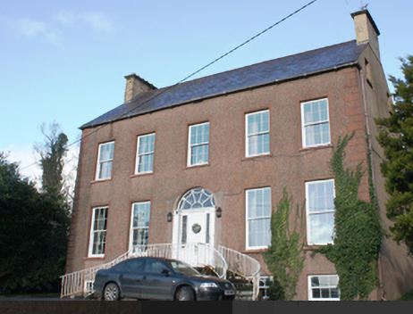
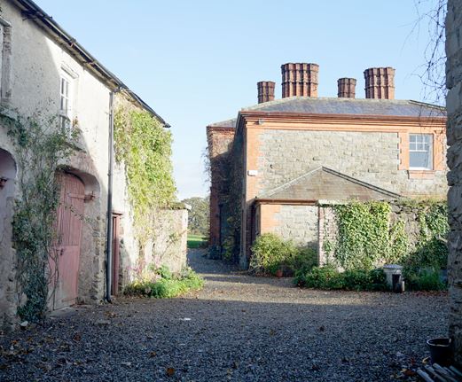
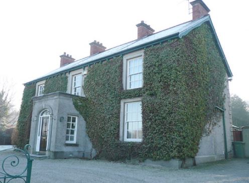
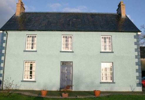
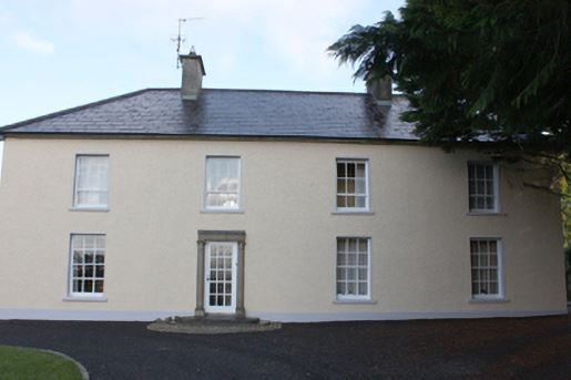
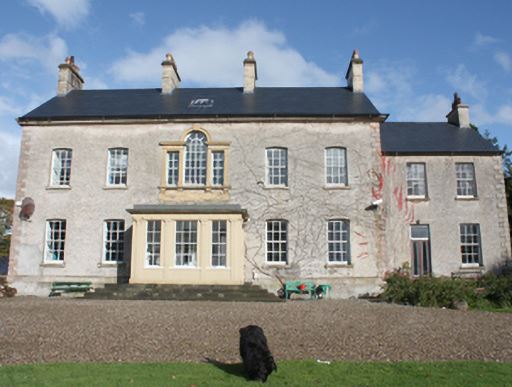
| Convoy House [Greenfield] | Robert Montgomery held this property in fee at the time of Griffiths Valuation when it was valued at £35. In 1837 Lewis had also referred to it as the seat of R. Montgomery. In 1896 it was owned Canon Boyton and valued at £33. The National Inventory of Architectural Heritage suggests it was built in the early years of the 19th century and provides a detailed description of its occupancy. It is still extant and occupied. |
![Photo of Convoy House [Greenfield]](https://landedestates.ie/storage/img/orig/3296.jpg)
|
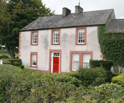
| Laurel Bank/Holly Bank | This house, originally known as Laurel Bank, is named on the first edition six inch Ordnance Survey map (publ. 1837). It is shown in a demesne which included an old bleach mill and a corn mill and kiln. It is believed to have been built by a mill owner in the 18th century. Griffith’s Valuation records William Norton as the occupant holding the property valued at £8.10.0. from the Earl of Gosford. The house is called Holly Bank on the 25 inch map. Altered and added to in the 20th century it continues to be a residence. |