Marble Hill (KIlmacrenan)
Houses within 10km of this house
Displaying 9 houses.
Houses within 10km of Marble Hill (KIlmacrenan)
Displaying 9 houses.
| House name | Description | |
|---|---|---|
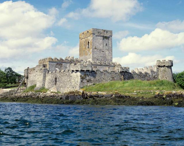
| Doe Castle (KIlmacrenan) | Alexander Maddison was leasing Doe Castle from the Hart estate at the time of Griffith’s Valuation in the 1850s, when it was valued at £21 15s. In 1837 Lewis recorded it as the seat of the Hart family but formerly in the possession of the Sandfords. The original tower house at the site, still extant, was the seat of the McSweeney clan in the medieval and early modern period. This site is now in the care of the Office of Public Works. |
|
| Heathfield (Kilmacrenan) | Reverend Alexander Nixon held a property valued at £17 10s in fee at Ray in the 1850s. No substantial house is labelled in Ray on the 1st edition Ordnance Survey map. However, Heathfield appears on both the 25-inch and later 6-inch edition, labelled “in ruins”. | |
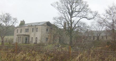
| Horn Head House | In 1786 Wilson referred to Horn Head House as the seat of Mr. Stewart. Lewis recorded Horn Head as the seat of W. Stewart in 1837. At the time of Griffith’s Valuation, it was occupied by Reverend Charles Frederick Stewart and valued at £27. In 1906 it was the property of Captain Charles F. Stewart and valued at almost £28. The National Inventory of Architectural Heritage suggests it was associated with the Stewart family since the early 18th century. It was sold by the family in the 1930s after it appeared that unstable sand dunes were encroaching on the site and has since been unoccupied. Since 2021 some work has been underway to renovate the property. |
|
| Ards | Wilson referred to Ards as the seat of Mr. Wray in 1786. Lewis recorded Ards as the seat of A. Stewart in 1837. At the time of Griffith’s Valuation it was occupied by Alexander Stewart when the buildings were valued at £100. In 1906 Ena D. Stewart was the owner when the house was valued at £90. Local sources suggest Ards remained in the Stewart family until 1927 when it was taken over by the Irish Land Commission. The house was later acquired by the Capuchin Order. A serious fire in the 1940s led to the demolition of the old house and a new friary was built some distance away. The demesne is now known as Ards Forest Park and is in the care of Coillte, the Irish forestry service. | |
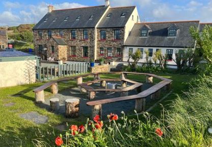
| Castlebane (Corcreggan) Mill House | This property was held in fee by the Stewart estate at the time of Griffith’s Valuation when it was valued at £26. The property is now a site offering guest accommodation, known as Corcreggan Mill. |
|
| Rampart [Ards Farm] (Kilmacrenan) | In 1906 Eva D. Stewart was the owner of buildings valued at £48 in the townland of Clonmore, parish of Clondahorky, County Donegal. At the time of Griffiths Valuation this property was known as Rampart and was occupied by Thomas Ingram, leasing from the Stewart estate. On the later Ordnance Survey maps a much larger complex of buildings is labelled Ards Farm. The original buildings are no longer extant. | |
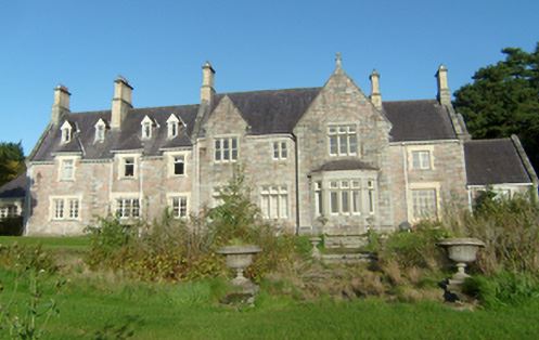
| Mulroy House | The National Inventory of Architectural Heritage suggests Mulroy House was built shortly after the publication of Griffiths Valuation in the late 1850s, as there is no substantial house recorded in Rawros townland in the valuation. There is a suggestion that it was primarily intended then as an estate headquarters rather than a country seat. Following the death of the 3rd Earl of Leitrim, it was inherited by the 4th Earl who greatly extended the property. In 1906, it was still in the ownership of the Clements estate and valued at almost £104. It is still extant and occupied. |
|
| Rosepenna Hotel | In 1906 the Earl of Leitrim's estate owned buildings valued at over £80 at Rosepenna, parish of Mevagh, County Donegal. This was the original Rosepenna Hotel, established as a golf resort in 1893. The original building was destroyed by fire in the 1960s. | |
| Drumnamallagh | This property is labelled Drumnamallagh on the 25-inch Ordnance Survey map of the early 20th century. A corn mill was located close by on the 1st edition map. This was leased by Edward McFadden from the Hart estate at the time of Griffiths Valuation in the 1850s when it was valued at £14. It is no longer extant. |