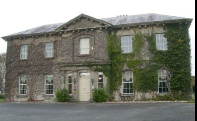
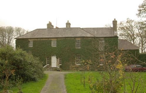
Ferns Hill Glebe House
Houses within 15km of this house
Displaying 49 houses.
Houses within 15km of Ferns Hill Glebe House
Displaying 49 houses.
| House name | Description | |
|---|---|---|
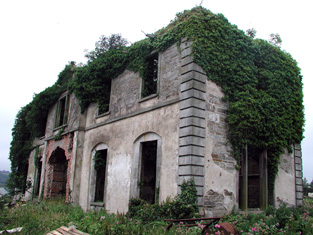
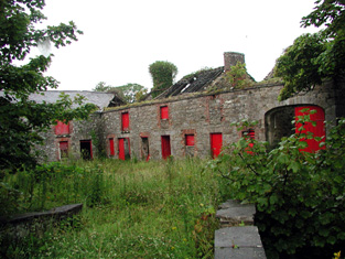
| Kinlough House (Oakfield House) | Kinlough House was originally known as Oakfield House and was the seat of the Johnston family from the early eighteenth century. It was remodelled in the 1820s by Robert Johnston and renamed Kinlough House. At the time of Griffith's Valuation, Kinlough House was occupied by William Johnston and was valued at £45. In 1906 James Johnston was the owner of the mansion house at Kinlough valued at £43 as well as 220 acres of untenanted demesne land. In 1943 the Irish Tourist Association Survey recorded that the house had been destroyed by fire some 20 years previously but that the gardens were still open to the public. Kinlough House is depicted in a ruined state in the Buildings of Ireland survey. Major new housing development is occuring on the site, adjacent to the walled garden. |
|
| Brookhill (Rossinver) | Brookhill is described as the residence of Capt. Johnston in 1835. At the time of Griffith's Valuation, it was occupied by Johnston Sharpe and valued at £10. In 1894 Slater notes that it was the seat of Capt. Forbes Johnston. It is the only Johnston residence still extant. |
|
| Tynte Lodge | Joseph Tynte was leasing lands from the White estate and later purchased 30 acres of land from Lord Massy (who had inherited that estate) for the building of Tynte Lodge. The Inventory of Architectual Heritage, however, contends that Tynte Lodge was built in the eighteenth century so perhaps Tynte was reconstructing an earlier building. At the time of Griffith's Valuation the property at Tullaghan was valued at £18 and was leased by Tynte to Hugh Montgomery. In 1906 Mervyn Tynte was the owner of the mansion house at Tullaghan valued at £51. |
|
| Ward House | At the time of Griffith's Valuation this property was held in fee by James Ellis when the house was valued at £10. It is labelled Ward House on both the 1st and 25-inch edition Ordnance Survey maps. The original house is no longer extant. | |
| Mount Prospect | At the time of Griffith's Valuation, William Johnston was leasing a house valued at £14 to Glasgon Connolly at Aghaderrard West, barony of Rosclogher. This is the house known as Mount Prospect. Both the Ordnance Survey Field Name Books and Lewis record Mount Prospect as a seat of the Connolly family in 1837. In 1894 and 1906 it was the property of St. George Robert Johnston and was also valued at £14. The remains of various buildings still exist although a new house seems to have been constructed at the site near the lake shore. |
|
| Woodville | Described in 1835 as formerly having good offices and a well-managed garden but had a deserted looking appearance at that time. The Irish Tourist Association survey in 1943 recorded that the ruins of Woodville House were located in the townland of Tawly. The house was demolished around 1908 when the estate was divided. | |
| Duncarbry Lodge | At the time of Griffith's Valuation John R. Dickson was the owner of two properties at Duncarbry, barony of Rossinver, one valued at £18 and the other at £10. Lewis records that Rev. Dickson was residing at Duncarbry Lodge in 1837. |
|
| Lareen | Lareen House was built in the 1820s by Luke White who died in 1854 and is buried in the old cemetery in Kinlough, the only member of the White family to be buried in the locality. Lareen then passed to the Massy family of county Limerick (Baron Massy of Duntrileague). In 1906 it, together with about 1200 acres of untenanted land in the area, was the property of Lord Massy. The house was valued at £23 at the time. Lareen was sold in the early 20th century to Maxwell Blacker Douglass who also bought fishing rights on both banks of the Drowes river and Bundrowes House. Lareen House burnt down in 1933. The Irish Tourist Association survey of 1943 mentions that it was in a ruined condition due to this fire. | |
| Tullaghan House | At the time of Griffith's Valuation Tullaghan House was in the possession of Joseph P. Tynte who was leasing it from Col.White's estate. Subsequently it became a residence of the Dickson family. It is still extant. |
|
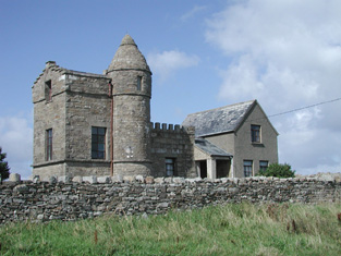
| Kilkilloge Tower | In 1906 the Ashley estate owned a property at Killkiloge, barony of Carbury, valued at £16. This may be the extant building which was modelled on a medieval look out tower. |
|
| Glenade House [Largydonnell] | The building at this site is labelled Largydonnell on the First Edition Ordnance Survey map. On the later 25-inch edition, Glenade House is noted. Loftus Tottenham was the owner of a property valued at £20 at Largydonnell, parish of Rossinver at the time of Griffith's Valuation. The sale in 1878 included this property. In 1894 Slater recorded it as the seat of George Loftus Tottenham. It is no longer extant. | |
| Portnason | Portnason was owned by the representatives of Christopher Allingham at the time of Griffith’s Valuation but was unoccupied. The National Inventory of Architectural Heritage suggests it was built in the early 19th century and may have replaced an earlier house, also associated with the Allingham family. It is still extant. |
|
| Stonewold | Edward Allingham was leasing a property at Ballyhanna from the Conolly estate at the time of Griffiths Valuation when it was valued at £20. It is labelled on both the 1st and 25-inch edition Ordnance Survey maps as Stone Wold. It was later associated with the Crawford family. Stone Wold was one of a number of properties demolished in the mid-1940s when several townlands were inundated as part of the Erne Hydro-Electric scheme. | |
| Willybrook | Edward Allingham was leasing this property from the Conolly estate at the time of Griffith’s Valuation, when it was valued at £20. The Allingham family owned several properties in this area of Ballyshannon throughout the 19th century. The site appears to be derelict now. | |
| Fair View (Dane Ville) | The property at this site is labelled as Fair View on the 1st edition Ordnance Survey map of the late 1830s. On the 25-inch edition of the early 20th century it is labelled Dane Ville Lodge. At the time of Griffith’s Valuation, it was being leased by Mrs. Deane from the representatives of Colonel Dickson and Thomas Conolly’s estate when it was valued at £18. The site is now occupied by a modern house. | |
| Rockfort Lodge | Charles Rochfort was occupying this property at the time of Griffith’s Valuation, leasing from the Dickson estate. It was then valued at £20. The house is still extant but does not appear to be in good repair. | |
| Laputa | Laputa was occupied by Robert Johnstone at the time of Griffith’s Valuation, when he was leasing it from the Conolly estate. It was then valued at £30. In 1837 Lewis had recorded it as the seat of J.F. Johnstone. It was one of a number of properties demolished in the mid-1940s when several townlands were inundated as part of the Erne Hydro-Electric scheme. | |
| Cherrymount (Ballyshannon) | Cherrymount was leased from Forbes Johnston’s estate by Hugh Tuthill at the time of Griffith’s Valuation, when it was valued at £16. Lewis recorded it as the seat of Dr. Crawford in 1837. In 1867 Forbes Johnston offered 160 acres of Cherrymount for sale in the Landed Estates Court. The sale notice stated that Hugh Tuthill's lease began in 1854, for 21 years. The property is labelled Cherrymount on the 1st and 25-inch Ordnance Survey maps. It was submerged under the waters of Assaroe Lake in the 1940s as part of the Erne Hydro Electric Scheme | |
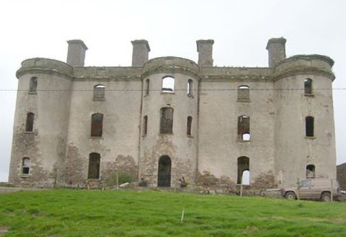
| Camlin Castle | Camlin was held in fee by John A. Tredennick at the time of Griffith’s Valuation, when it was valued at £65. It is largely demolished owning to the expectation, unfounded as it turned out, that the site would be flooded by the Erne Hydro Electric scheme in the 1940s. | |
| Fort William (Ballyshannon) | William Tredennick was occupying this property at the time of Griffith’s Valuation, when it was valued at £28. The National Inventory of Architectural Heritage suggests it remained in the ownership of the Tredennick family until the 1920s. It is still extant and occupied | |
| Mullans House | Robert Reynolds was leasing this property from John A. Tredennick at the time of Griffith’s Valuation, when it was valued at £20. It remained extant and occupied until the mid-1940s when it was demolished in advance of the Erne Hydro Electric scheme. | |
| Coxtown Manor | Coxtown Manor was occupied by Alexander Hamilton at the time of Griffith’s Valuation in the 1850s. He was leasing from the Provost and Fellows of Trinity College. The house was valued at £35. In 1901 Coxtown was occupied by William Alexander Hamilton and his family. The house is still extant and occupied |
|
| Urbalshinny | William Armstrong was leasing two properties which included a house and large mill complex, from the Hamilton estate at the time of Griffith’s Valuation. One, leased from Andrew Hamilton, was valued at £95, while the second leased from the representatives of John Hamilton, was valued at £37. The extensive ruins of these mill buildings and their associated houses are still visible in the landscape | |
| Brown Hall | The house at Brownhall was valued at £35 at the time of Griffith’s Valuation, when it was occupied by James Hamilton, junior who held it in fee. Brownhall is still extant and occupied. In 1837 Lewis recorded it as the seat of Edward Hamilton.The house is labelled Brownhall on all editions of Ordnance Survey maps and a house remains at the site. The National Inventory of Architectural Heritage suggests the original part was constructed in the late seventeenth or early eighteenth century but the house currently in use is later than that. | |
| Coolbeg | ||
| Drumbeg House (Inver) | A house named Drumbeg or Cloverhill is shown in the townland of the same name on the 25-inch Ordnance Survey map. At the time of Griffith’s Valuation in the 1850s, it leased by William Sinclair from the Conyngham estate and valued at £21 15s. Drumbeg House is still extant. |
|
| Spamount (Killaghtee) | Sarah Stephens was leasing this property from Reverend Samuel Montgomery’s estate at the time of Griffith’s Valuation. The house was valued at £12. Lewis recorded it as the seat of M. Steevens in 1837. In 1911 the house was owned by Francis P. Henry. It is labelled Spamount on all Ordnance Survey maps. Buildings are still extant at the site. | |
| Cavangarden House | Thomas J. Atkinson held this property in fee at the time of Griffith’s Valuation, when it was valued at £20. It still held this valuation in 1906. A second property in the townland, valued at almost £8, was occupied by John Atkinson, leasing from William Atkinson. Lewis had also noted it as a seat of the Atkinson family in 1837. Cavangarden is still a working farm where guest accommodation is provided. | |
| Rowantreehill (Kilbarron) | John Faucett was leasing this property to Francis Faucett at the time of Griffith’s Valuation, when it was valued at £13. The National Inventory of Architectural Heritage suggests the earliest part of the house may date from the mid-18th century and that it was associated with both the Faucett/Fawcett and Tredennick families in the 19th century |
|
| Belville (Banagh) | John Bustard held this property in fee at the time of Griffith’s Valuation, when it was valued at £13. It continued to be associated with the Bustard family throughout the nineteenth century. Though a building is shown at the site on the 1st edition Ordnance Survey map it has been substantially expanded by the publication of the 25-inch edition map and is labelled Belville. In 1906 the property here owned by George Bustard was valued at £13. It is still extant. | |
| Fair View, later Dane Ville | The property at this site is labelled as Fair View on the 1st edition Ordnance Survey map of the late 1830s. On the 25-inch edition of the early 20th century it is labelled Dane Ville Lodge. At the time of Griffith’s Valuation, it was being leased by Mrs. Deane from the representatives of Colonel Dickson and Thomas Conolly’s estate when it was valued at £18. The site is now occupied by a modern house. | |
| Mahgeracar | At the time of Griffith’s Valuation, in the 1850s, Thomas Ellis was leasing property in Magheracar townland from the Conolly estate. The building was valued at £15 15s. Ellis, in turn, was leasing a property to William Forde, valued at over £10. | |
| Rose Lodge or Dingleicoush | Penelope St. George was leasing this property from the Conolly estate at the time of Griffith’s Valuation, when it was valued at £17. The house is no longer extant. On some earlier maps it is labelled as Rose Lodge but on the 25-inch map of the early 20th century it is labelled Dingleicoush. | |
| Willybrook | Edward Allingham was leasing this property from the Conolly estate at the time of Griffith’s Valuation, when it was valued at £20. The Allingham family owned several properties in this area of Ballyshannon throughout the 19th century. The site appears to be derelict now. | |
| Higginstown House | Henry Coen was leasing Higginstown House from the Conolly estate at the time of Griffith’s Valuation, when it was valued at £13. By 1906 it was still in Coen ownership and valued at £20. It is now a ruin. Coen was, in turn, leasing a smaller property, known as Waterloo Cottage (G874606), to Frances Sheil. This house was valued at almost £10. It is still extant. | |
| Stonewold | Edward Allingham was leasing a property at Ballyhanna from the Conolly estate at the time of Griffiths Valuation when it was valued at £20. It is labelled on both the 1st and 25-inch edition Ordnance Survey maps as Stone Wold. This house was recorded as the address of Johnston Teevan, solicitor, at the time of his death in 1872. It was one of a number of properties demolished in the mid-1940s when several townlands were inundated as part of the Erne Hydro-Electric scheme. | |
| Laputa | Laputa was occupied by Robert Johnstone at the time of Griffith’s Valuation, when he was leasing it from the Conolly estate. It was then valued at £30. It was one of a number of properties demolished in the mid-1940s when several townlands were inundated as part of the Erne Hydro-Electric scheme. | |
| Templenew House | James Thornly was leasing this property from the Conolly estate at the time of Griffith’s Valuation when it was valued at £16. It is still extant. |
|
| Rockfield House (Tirhugh) | Patrick Brady was leasing this property from the Conolly estate at the time of Griffith’s Valuation, when it was valued at £13. It is labelled as Rockfield House on the 25-inch Ordnance Survey map of the early 20th century. It is still extant. |
|
| The Hall (Inver) | This property was held in fee by the Marquis of Conyngham’s estate at the time of Griffith’s Valuation, when it was valued at £38. Lewis records that it was occupied by a Colonel Pratt in 1837, though notes that it was a seat of the Conyngham family. The National Inventory of Architectural Heritage suggests the house was built some time in the 1750s. It is still extant. |
|
| Salthill House (Inver) | Robert Russell was leasing this property from the Conyngham estate at the time of Griffith’s Valuation when it was valued at £20. It is still extant and occupied. A smaller property, labelled Sea View, is shown on the shoreline adjacent to the main house on the 1st edition Ordnance Survey map but is not labelled on the later editions. |
|
| Wood Lodge (Inver) | Daniel J. Cruise was occupying this property at the time of Griffith’s Valuation, when it was valued at £10 and leased from the Conyngham estate. It is labelled Wood Lodge on the 25-inch Ordnance Survey map. | |
| Brown Hall (Tirhugh) | James Hamilton held Brownhall in fee at the time of Griffith’s Valuation, when it was valued at £35. In 1837 Lewis recorded Brown Hall as the seat of Reverend Edward Hamilton. The house is labelled Brownhall on all editions of Ordnance Survey maps and a house remains at the site. The National Inventory of Architectural Heritage suggests the original part was constructed in the late seventeenth or early eighteenth century but the house currently in use is later than that. | |
| St. Ernans | John Hamilton held St. Ernans in fee at the time of Griffith’s Valuation when the building complex was valued at £46 as well as a mill valued at £28. In the later 20th century the property functioned as a hotel. The National Inventory of Architectural Heritage suggests it was built in the 1820s but extended and modified later in the nineteenth century. It is still extant. |
|
| Wardtown | In 1837 Lewis recorded "Wardton" as a residence of J. ffolliott. At the time of Griffiths Valuation it was leased from the ffolliott estate by Henry Likely and valued at £20. The National Inventory of Architectural Heriage suggests the house was built c.1739-1740 but has been out of use since 1916 and is now a ruin. |
|
| Rockville (Ballyshannon) | At the time of Griffiths Valuation in the 1850s, this property was being leased to Mary O'Neill by Edward Jones. Local sources suggest, however, that it was a residence of the ffolliott family and burned in the 1920s. | |
| Murvagh House | Reverend John Kincaid held this property in fee at the time of Griffiths Valuation in the 1850s, when it was valued at £25. It is labelled Glebe House on the 1st edition Ordnance Survey map but as Murvagh House on the 25-inch map of the early twentieth century. It is still extant. |
|
| Rossyvolan | At the time of Griffiths Valuation in the 1850s, this property was leased by Frederick Milburne from a Miss Miller. Documents relating to estate administration including this townland are held in the Hamilton of Brownhall papers at the Public Record Office of Northern Ireland. The site is now occupied by farm buildings. | |
| Kilmacreddan House | At the time of Griffiths Valuation, Sophia Major was leasing this property from the Barton estate, when it was valued at £9. In 1868 it was offered for sale in the Landed Estates Court by Sophia Keane when the petitioner was Alexander Buchanan. Kilmacreddan is still labelled on the last edition of the 6-inch Ordnance Survey map but is no longer extant. |