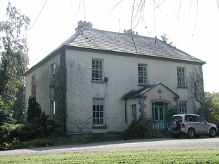
Riversfield (Upper Ormond)
Houses within 10km of this house
Displaying 20 houses.
Houses within 10km of Riversfield (Upper Ormond)
Displaying 20 houses.
| House name | Description | |
|---|---|---|
| Fort William | The Ordnance Survey Name Books refer to correspondence with John Cooke in the parish of Glenkeen in 1840. This house was occupied by Mrs Margaret Cooke in the mid 19th century and held from the Earl of Portarlington, valued at £13.10 shillings. John W. Cooke was resident here in the 1870s. Fort William is still extant and occupied. |
|
| Summerhill | Richard Bourke was resident at Summer-hill, Burris-o-leagh, in 1814 but by 1837 J.H. Harden was the proprietor. At the time of Griffith's Valuation Charles F. Harden held the house, valued at £11, from John H. Harden. Buildings are still extant at this site. | |
| Monaquil | Burke's ''Landed Gentry of Ireland'' (1904) records Philip Going of Monaquil, sixth son of Robert and Jane Going. In 1767 Philip married Grace Bernard. Their grandson, Reverend Philip Going Atkins Going, succeeded to the Monaquil property by the will of his maternal grandfather, who died in 1820. Monaquil was occupied by the Atkins family in 1837. In 1840 the Ordnance Survey Name Books record that "Mr. O'Shea, proprietor, states that he has nothing to do now ith Monaquil, it is under the Courts" and that the house was then occupied by a Mrs. Bennett. It was vacant at the time of Griffith's Valuation. when Reverend Hastings Atkins was the immediate lessor and the house was valued at £19. The Butler sale rental of 1866 records a fee farm grant dated 19 May 1859, John Butler to Reverend Philip Going Atkins Going. The Atkins sale rental of 1877 records the leasing of Monaquil to Robert William Henry Roe in 1864. The original house marked on the first edition Ordnance Survey Map was replaced by another house slightly to the north in the late 19th century. | |
| Lismore | A house on the Toler estate, occupied by John Pepper and valued at £13+ in the mid 19th century. A building is still located at this site. | |
| Debsborough | The seat of the Bayly family in the 18th and 19th centuries, occupied by successive John Bayly/Bailys and held in fee. The Ordnance Survey Name Books describe it as "a large demesnewith commodious dwelling house" in 1840. In the mid 19th century the house was valued at £38+ and in 1906 at £65. A building is still located at this site. | |
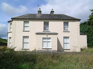
| Ballynaclogh House | The home of Richard Uniacke Bayly and his family in the 19th century, held from his brother John. The house was valued at almost £17 at the time of Griffith's Valuation. This house is still extant and occupied. |
|
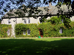
| Bayly's Farm | The home of Lancelot P. Bayly and his family in the 19th century, held from his brother John. The house was valued at £13.6 shillings at the time of Griffith's Valuation. This house with modern additions still functions as a residence. It also offers guest accommodation. See www.baylyfarm.ie. |
|
| Coolagh | Coolagh is described in the Ordnance Survey Name Books as "a good dwelling house in a small demesne with plantation and ornamental ground" in 1841. It was occupied by John Brindley in the mid 19th century. Valued at £12+ it was held from the Very Reverend Dean Head. It is still extant. | |
| Happygrove House | In 1840 the Ordnance Survey Name Books refer to "Happy Grove" as "the name of the place and residence of Mr. John Brindley" and gives details of the oatmeal mill in the demesne. Samuel Brindley was the proprietor of a corn mill and house at Clonmore in the mid 19th century. He held the property from Lord Dunalley and the buildings were valued at £35. The house no longer exists. | |
| Grenanstown | Wilson refers to Grenan's-town as the seat of Mr. Dalton in 1786. In 1837 Lewis describes Grenanstown as the seat of Count D'Alton. The Ordnance Survey Name Books note that James Williams was leasing Grenanstown but that it was occasionally the residence of Count D'Alton. At the time of Griffith's Valuation James Williams occupied Grenanstown. He held the property from Count D'Alton and the buildings were valued at £19.11 shillings. The National Inventory of Architectural Heritage states that Richard Dalton Williams (1822-1862), poet and Young Irelander, lived here as a child. This house was later the property of Henry Eustace, a member of the Robertstown, county Kildare family. It is now a ruin. |
|
| Shanbally | Shanbally was occupied by John Gasson in 1814 but had become the home of Peter Smithwick by 1837. He held the property from Samuel Gason in the mid 19th century when the house was valued at £26.13 shillings. The Ordnance Survey Name Books describe it as "a good dwelling house". In 1894 Slater refers to it as the residence of John Smithwick. It is still extant. |
|
| Traverston | Traverston was the seat of the Going family in the 18th and 19th centuries. In 1786 Wilson refers to it as Trevor's-town, the seat of R.Going. It was the residence of Thomas Going in 1814 and 1837. The Ordnance Survey Name Books describe it as "a splendid residence" in 1840. In the mid 19th century Caleb Going occupied the house and held the property in fee. The buildings were valued at £52+. Still valued at £52 and occupied by John R. Lloyd in 1906. John R. Lloyd was the son of Anne, daughter of Robert Going of Cragg, Newport, who, in 1828, married Edward Lloyd of 12 Upper Mount Street, Dublin. John R. Lloyd died unmarried in 1910 and left Traverston to his niece, Ann Norris. This house is now demolished. see http://www.glendafae.com/histories/Going%20of%20TRAVERSTON.pdf | |
| Ballinamona | A house valued at £11+ on the estate of the Honourable O.F.G. Toler and occupied by Newton Short in the mid 19th century. The Ordnance Survey Name Books refer to it as "a good dwelling house" in 1840. A house is still extant at this location. | |
| Kilboy | In 1786, Kilboy was described by Wilson as the fine seat of Henry Prittie. Lord Dunalley is recording as resident at Dunally Castle, Nenagh, in 1814. In 1837 Lewis writes that Kilboy, the seat of Lord Dunalley, "was erected about 60 years since". In the mid 19th century it was valued at £76+ and held in fee. This house, which the National Inventory of Architectural Heritage describes as a "detached five-bay single-storey house over basement, built c. 1775" and designed by William Leeson, was destroyed in 1922. A similar house was erected on the site but was demolished in 1955. A smaller house is now located on the site. |
|
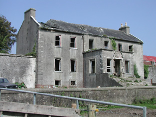
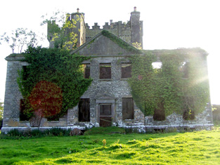
| Castle Otway | Castle Otway was the seat of the Otway family in the 18th and 19th centuries. It was a mid 18th century house with a tower house attached, altered and renovated in the 19th century. In the mid 19th century the castle, valued at £47.17 shillings, was held by the Honourable Mrs Otway Cave in fee. The sale rental includes a lithograph of the house. Slater refers to it as the seat of William Otway Ruthven in 1894. The representatives of Robert J. Otway occupied this house in 1906. It is now a ruin. |
|
| Millbrook | Described by Wilson as the seat of Mr. Hawkshaw in 1786, Millbrok was also the home of the Hawkeshaw family in the 19th century, occupied by Richard Hawkshaw in 1814 and of his representatives in the early 1850s, when it was held from George Armstrong and valued at £19+. Millbrook House was included in the sale of the Earl of Listowel's estate in 1861. Michael Dwyer was the tenant. A building is still located at this site. | |
| Norwood | In 1841 the Ordnance Survey Name Books described Norwood as "a good dwelling house occupied by a member of the Minchin family" though Simpson Hackett is noted as the proprietor. Captain David Joyce was resident in the mid 19th century when the house was valued at £15+ and held from Thomas Hackett. This house is still extant. |
|
| Ballyquiveen | A house built post the first edition Ordnance Survey map of circa 1838. John Brindley was leasing a house from Dean Head valued at £5+ at Ballyquiveen at the time of Griffith's Valuation. It is no longer extant. | |
| Tiermoyle House | In 1786 Wilson refers to Tiermoyle as the seat of Mr. Crawford. In 1840 the Ordnance Survey Name books refers toTiermoyle as a residence of Cooper Crawford and "about 20 years ago it was then a place of some account but it is now in a state of dilapidation". By the time of Griffith's Valuation, this house was occupied by Mrs. Costelloe, leasing from Countess Norbury's estate and valued at almost £4. A farm is still extant at the site. | |
| Ballycrenode House | In 1840 the Ordnance Survey Name Books refer to the site of Ballycrenode House in the parish of Kilkeary, stating "only those people who are very old can recollect seeing any part of this house standing". This original Ballycrenode House belonged to the O'Carroll family and the last inhabitant was a Major O'Carroll. The site is marked on the 1st edition Ordnance Survey Map. At that time and in Griffith's Valuation, the townland belonged to the Toler estate. The 25-inch map of the 1890s shows a later Ballycrenode House, located slightly to the north-west of the original site. This property is still extant, part of a large farm. |