Uskane
Houses within 5km of this house
Displaying 17 houses.
Houses within 5km of Uskane
Displaying 17 houses.
| House name | Description | |
|---|---|---|
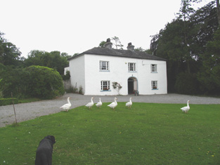
| Fortmoy House Lower | In 1840 the Ordnance Survey Name books refer to "Fordmoy" as "a good dwellinghouse, lately built, the residence of Mr. Prendergast".This house was vacant at the time of Griffith's Valuation. Thomas G. Prendergast was the immediate lessor and the house was valued at £11. Buildings valued at £27.5 shillings were held by the representatives of David Clarke at Fortmoy in 1906. Fortmoy House Lower is still extant. |
|
| Spring Park | In the mid 19th century Benjamin Armitage occupied a house valued at £10 in Gortnagrann which he held with 243 acres from William Woods. The Ordnance Survey Name Books note it as being occupied by Mr. Armitage in 1841. The site is now occupied by farm buildings. | |
| Milford | Lewis records Milford as the occasional residence of Ralph Smith. By the early 1850s it was occupied by Thomas Bunbury and held from William Woods. Bence Jones writes that it was the home of Edmond Murphy who died in 1882. In 1840, he Ordnance Survey Name Books refer to the house as the residence of John Monsell and describe the demesne as "principally composed of plantation and ornamental grounds". |

|
| Lisbryan | Lisbrien or Lisbryan, near Ballingarry, was occupied by Faulkner Esq in the 1770s and 1780s. Sir Robert Waller Baronet was occupying this house in 1814. Lewis records T. Bunbury as the proprietor in 1837. The Ordnance Survey Name Books, also refer to it as his residence, "a very extensive building of the modern style". Thomas Bunbury held the property from Lord Ashtown at the time of Griffith's Valuation when the buildings were valued at £40+. Lisbryan is still extant. |

|
| South Park | In the 1770s Abbot Esq was residing at Rahanane close to Ballingarry. Wilson, writing in 1786, also refers to Rahanane as the seat of Mr. Abbott. The house is named South Park on the 1st edition Ordnance Survey map and was the home of a branch of the Atkinson family, occupied by Anthony Atkinson in 1814 and by C. Atkinson in 1837. Charles Atkinson held the property from Lord Ashtown at the time of Griffith's Valuation when the house was valued at £22. The estate of Edward Evans of Southpark, 174 acres in the barony of Lower Ormond, was advertised for sale in December 1859. South Park is still extant. |
|
| Ballingarry | Situated just north of Ballingarry castle Ballingarry House was built circa 1820. Lewis records Marmaduke Thompson as resident at Ballingarry Castle in 1837 as does the Ordnance Survey Name Books in 1841 though they refer to Lord Ashtown as the proprietor. The Thompson interest in Ballingarry and Ballinahinch was for sale in June 1850. Henry Trench was the occupier in the early 1850s holding the property form Lord Ashtown. Ballingarry House is still extant and occupied. |
|
| Lismacrory | An early home of the Smith family in county Tipperary. Lewis writes that Lismacrony was the ancient residence of the family of Smith now the property of Mr Bunbury. This house was in ruins at the time of the first edition Ordnance Survey map. In 1841, the Ordnance Survey Name Books description says "it was a very commodious house of the modern style of architecture with extensive offices attached to it, but it is now falling into ruins, the last occupier was Rev. Mr. Smyth of Ballingarry". | |
| Sopwell Hall | Apparently named after an English property, Sopwell in Hertfordshire, which was inherited by the Sadleir family. In 1655 a Cromwellian soldier, Colonel Thomas Sadleir, was granted Kinelagh Castle, county Tipperary, which he renamed Sopwell Hall. This property remained in Sadleir possession until it was inherited by Mary Sadleir who, in 1754, had married Frederick Trench of Woodlawn, county Galway, the parents of the 1st Lord Ashtown. The present house was built by Mary's father, Francis Sadleir, in the mid 18th century. Wilson refers to it as the residence of Mr. Sadlier in 1786. Sopwell Hall was left to Francis Trench, brother of 1st Lord Ashtown, who was living at Sopwell Hall in 1814. In 1837 Lewis records the Trenches in possession and writes that "on the demesne are the ruins of the ancient castle formerly occupied by the Sadleir family". The Ordnance Survey Name Books, in 1840, refer to Sopwell as "a spacious building, the residence of Stewart Trench". At the time of Griffith's Valuation the 2nd Lord Ashtown, son of Francis, was occupying the house, valued at £40 and held by him in fee. By 1906 Sopwell was valued at £80 and occupied by the Honourable Cosby G. Trench. The Trench family were still resident at Sopwell Hall in the 1970s. In 1840 the Ordnance Survey Name Books noted that Sopwell was one of the largest demesnes in the country. |

|
| Killavalla | Lewis records Killavalla as the seat of R. Johnston Stoney. The Ordnance Survey Name Books refer to the house in this townland as "Honeywood House, the residence of Robert Johnstone Stoney, very commodious with convenient offices attached". Stoney's representatives held the property valued at £16+ from the representatives of Stephen Egan at the time of Griffith's Valuation. It later became the seat of the Saunders family. This house no longer exists. |
|
| Greyfort Cottage [later Greyfort House] | The Stoneys were residing at Greyfort from at least the 1770s as recorded by Taylor and Skinner and also by Wilson in 1786. A house known as Greyfort Cottage was marked on the first edition Ordnance Survey map at this location and is also mentioned in the Ordnance Survey Name Books which refers to it as "a good dwelling house, the residence of Henry Owen Saunders". On later maps a different building in the townland is known as Greyfort House. Biggs A. Stoney was living at Grey-fort, Borrisokane, in 1814 and Saunders is recorded as the proprietor by Lewis. William Gray was the occupier of a house in Greyfort townland, valued at £12+, at the time of Griffith's Valuation and held from Henry O. Saunders. Thomas R. Grey of Greyfort House owned 500 acres in the 1870s. Buildings are still extant at this site. | |
| Bushy Park | Bushy Park was the home of Thomas Towers in 1814 and in 1837. In 1840, the Ordnance Survey Name Books refer to it as " a comfortable house, the residence of Thomas Towers" and also include reference to a letter written by Mr. Towers in which he expressed the wish that the house would revert to the name Shesharaghmore house though this does not seem to have happened. Sarah Cambie was occupying the house valued at £15 and held from Thomas Towers in the mid 19th century. David Clarke is described as "of Bushy Park, Borrisokane and Macclesfield" in the 1870s. Still valued at £15 this house was held by the representatives of David Clarke in 1906. A building is still extant at the site. | |
| Riversdale | This house was built after the first Ordnance Survey. At the time of Griffith's Valuation Thomas S. D. Robinson is recorded as the occupier of a house valued at £15 in the townland of Ballynavin. He held the property in fee. Thomas S.D. Robinson was still living at Riversdale in the 1870s. This house continues to be used as a residence. |

|
| Coorevin | Lewis records Cooreavan as the property of R. Hall in 1837. In 1840 the Ordnance Survey Name Books indicate that it was occupied by "Mr Gorey Baker, Burresokane". Jeremiah P[ierce] Scully was the occupier at the time of Griffith's Valuation, holding the property from the representatives of Robert Hall. The buildings were valued at £11. A building is still located at this site. | |
| Fort Nisbitt | Robert Nesbett was resident at Fort Nesbett in 1814. The Ordnance Survey Name Books also mention him in 1839 though they refer to Thomas Towers as the proprietor of the townland. In the early 1850s, Thomas O'Brien was the occupier, holding the property from the Reverend James Nesbitt. The buildings were valued at £12.15 shillings. A building is still located at this site. | |
| Derrinvohil | This house was not built at the time of the first Ordnance Survey. It bears the name of a townland but was originally located in the townland just to the west of Derrinvohil. The townland boundary has now altered and the house is in the townland of Derrinvohil. It was built by James Jocelyn Poe in 1845. Valued at £17 at the time of Griffith's Valuation and held from the Messrs Saurin. The house continues to function as a residence. |
|
| Castle Sheppard | The Sheppards were living here from at least the 1770s.In 1786 Wilson refers to Castle Sheppard as the seat of "Mr. Shepherd". It was the home of a junior branch of the family. William Sheppard was resident in 1837 and in the early 1850s when the house was valued at £26 and held from Lord Ashtown. William died at Castle Sheppard in 1852 without heirs and both his brothers died unmarried in India. Valued at £18 in 1906 and occupied by the Honourable Cosby G. Trench. This house is now a ruin. | |
| Fort Henry [Greyfort Cottage] Borrisokane | In 1840, the Ordnance Survey Name Books refer to "Fort Henry, a commodious house, the residence of Henry Ely" in the townland of Greyfort, parish of Borrisokane. At the time of Griffith's Valuation, Henry Ely was leasing a property valued at almost £5 from the Saunders estate in this townland. This may refer to the property shown on the 1st edition Ordnance Survey map as Greyfort House. On the later 25-inch map of the 1890s it is known as Greyfort Cottage. A house is still extant at the site. |