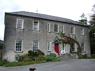
Lacka
Houses within 5km of this house
Displaying 16 houses.
Houses within 5km of Lacka
Displaying 16 houses.
| House name | Description | |
|---|---|---|
| Lisbryan | Lisbrien or Lisbryan, near Ballingarry, was occupied by Faulkner Esq in the 1770s and 1780s. Sir Robert Waller Baronet was occupying this house in 1814. Lewis records T. Bunbury as the proprietor in 1837. The Ordnance Survey Name Books, also refer to it as his residence, "a very extensive building of the modern style". Thomas Bunbury held the property from Lord Ashtown at the time of Griffith's Valuation when the buildings were valued at £40+. Lisbryan is still extant. |

|
| Ballymona | Ralph Smith was resident at Ballymona in 1837 and in the early 1850s. The Ordnance Survey Name Books refer to the house as " a plain modern building" in 1841. Smyth held the property from Lord Ashtown and the buildings were valued at £25. This house is now a ruin. | |
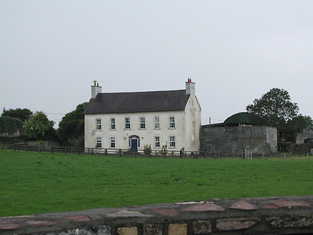
| Fairyhill | Fairyhill was the home of William Henry Cox in 1837. The Ordnance Survey Name Books describe it as "a large mansion house, the residence of Mr. Cocks [sic]" in 1841. It was occupied by Ellen Robinson in the early 1850s, when the house was valued at £19 and held from Lord Ashtown. Valued at £16 in 1906 and held by George W. Robinson. This house is still in use as a residence. |

|
| South Park | In the 1770s Abbot Esq was residing at Rahanane close to Ballingarry. Wilson, writing in 1786, also refers to Rahanane as the seat of Mr. Abbott. The house is named South Park on the 1st edition Ordnance Survey map and was the home of a branch of the Atkinson family, occupied by Anthony Atkinson in 1814 and by C. Atkinson in 1837. Charles Atkinson held the property from Lord Ashtown at the time of Griffith's Valuation when the house was valued at £22. The estate of Edward Evans of Southpark, 174 acres in the barony of Lower Ormond, was advertised for sale in December 1859. South Park is still extant. |
|
| Ballingarry | Situated just north of Ballingarry castle Ballingarry House was built circa 1820. Lewis records Marmaduke Thompson as resident at Ballingarry Castle in 1837 as does the Ordnance Survey Name Books in 1841 though they refer to Lord Ashtown as the proprietor. The Thompson interest in Ballingarry and Ballinahinch was for sale in June 1850. Henry Trench was the occupier in the early 1850s holding the property form Lord Ashtown. Ballingarry House is still extant and occupied. |
|
| Lismacrory | An early home of the Smith family in county Tipperary. Lewis writes that Lismacrony was the ancient residence of the family of Smith now the property of Mr Bunbury. This house was in ruins at the time of the first edition Ordnance Survey map. In 1841, the Ordnance Survey Name Books description says "it was a very commodious house of the modern style of architecture with extensive offices attached to it, but it is now falling into ruins, the last occupier was Rev. Mr. Smyth of Ballingarry". | |
| Clifton | Lewis records Clifton as the seat of Captain Sheppard. The Ordnance Survey Name Books refer to it as "a modern building, the residence of Capt. Sheppard" in 1841. Arthur Sheppard [?] was the occupier at the time of Griffith's Valuation. He held the property from Thomas Pyke and the buildings were valued at £14.10 shillings. The National Inventory of Architectural Heritage records the present house as dating from 1868. |
|
| Oak Park | The Ordnance Survey Name Books refer to Oakpark House as "a good dwelling house, the residence of Mr. Wm. Abernethy" in 1841. It was valued at £13+ and leased by William Abernethy from Colonel Hardress Lloyd at the time of Griffith's Valuation. It was advertised for sale in May 1875 as part of the estate of James Abernethy. A building is still located at this site. | |
| Elm Hall | Lewis records Elm Hall as the residence of Peter Burke while the Ordnance Survey Name Books refer to it as that of "Counsellor Burke". By the time of Griffith's Valuation his son Joseph Burke was the occupier, holding the property in fee, the house was valued at £10. A farm building now occupies the site of Elm Hall. |
|
| Carrig | The National Inventory of Architectural Heritage describes this as a miller's house. In 1840 The Ordnance Survey Name Books refer to it as " a good dwelling house, the residence of Christopher Dignan, there is a good flour mill close by". William Abernethy held it from the Earl of Portarlington in the mid 19th century when the house was valued at £20. It is now a ruin. James Abernethy of Carrig owned 113 acres in county Tipperary in the 1870s. |
|
| Gurteen | Gurteen was the home of Willliam Smith in 1814 and of George Smith in 1837. At the time of Griffith's Valuation George Smith held the property from Lord Ashtown. The buildings were valued at £13. The Smiths were still living at Gurteen in the 1870s. Gurteen is now the centre of an agricultural college. http://www.gurteencollege.ie/index.html | |
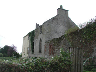
| Wingfield | A house located just inside the county Tipperary border with county Offaly. The property belonged to John Shortt in the mid 18th century. When he died in 1768 his widow Frances (nee Spunner) married Jonathan Doolan. Wingfield was occupied by Jonathan's son Thomas Doolan in 1814 and in 1837. The Ordnance Survey Name Books refer to it as the residence of [Paliner?] Thomas Doolan in 1840. By the time of Griffith's Valuation Henry Spunner was resident. He held the property from Jonathan Short and the buildings were valued at £20. Richard Thomas Croasdaile and his sister Margaret occupied the house in 1901. This house is now a ruin. |
|
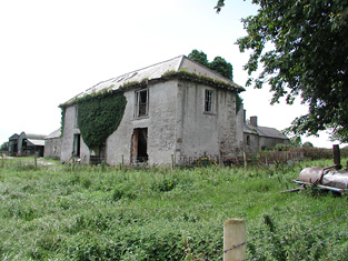
| Castle Sheppard | The Sheppards were living here from at least the 1770s.In 1786 Wilson refers to Castle Sheppard as the seat of "Mr. Shepherd". It was the home of a junior branch of the family. William Sheppard was resident in 1837 and in the early 1850s when the house was valued at £26 and held from Lord Ashtown. William died at Castle Sheppard in 1852 without heirs and both his brothers died unmarried in India. Valued at £18 in 1906 and occupied by the Honourable Cosby G. Trench. This house is now a ruin. | |
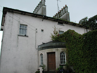
| Loughkeen Glebe | In 1840 the Ordnance Survey Name Books describe the Glebe at Loughkeen as "a good dwelling house the residence of Rector Synge". At the time of Griffith's Valuation, it was leased by Reverend Francis Synge from the Ecclesiastical Commissioners and valued at £23+. It is still extant and occupied. |
|
| Ivy Hall (Loughkeen) | The Ordnance Survey Name Books refer to Ivy Hall as the residence of Richard Palmer in 1840. By the time of Griffith's Valuation, it was occupied by Mary Anne Palmer, who was leasing from William Abernethy, and valued at almost £8. Ivy Hall is still extant and occupied. |
|
| Rockville (Loughkeen) | The Ordnance Survey Name Books refer to Rock Ville House in the parish of Loughkeen as the residence of Mr. S. Lloyd in 1841. At the time of Giffith's Valuation, a house in this townland valued at £10 was occupied by William Kent, leasing from Jane Downs. On the 25-inch map of the 1890s this house is labelled Carrig Cottage. It is still extant. |