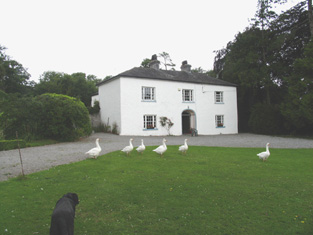
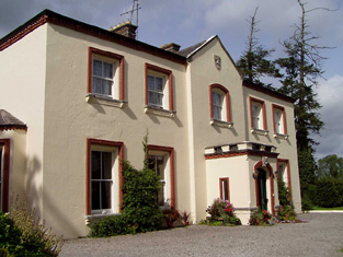
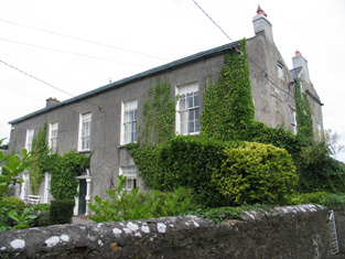
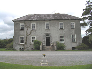
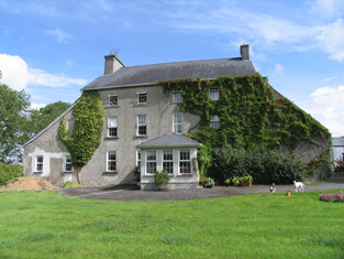
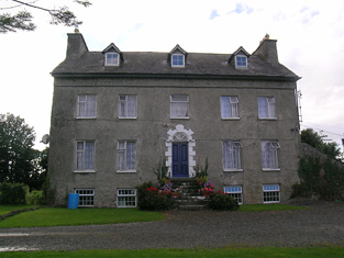
Elm Hall
Houses within 10km of this house
Displaying 39 houses.
Houses within 10km of Elm Hall
Displaying 39 houses.
| House name | Description | |
|---|---|---|
| Fortmoy House Lower | In 1840 the Ordnance Survey Name books refer to "Fordmoy" as "a good dwellinghouse, lately built, the residence of Mr. Prendergast".This house was vacant at the time of Griffith's Valuation. Thomas G. Prendergast was the immediate lessor and the house was valued at £11. Buildings valued at £27.5 shillings were held by the representatives of David Clarke at Fortmoy in 1906. Fortmoy House Lower is still extant. |
|
| Lisbryan | Lisbrien or Lisbryan, near Ballingarry, was occupied by Faulkner Esq in the 1770s and 1780s. Sir Robert Waller Baronet was occupying this house in 1814. Lewis records T. Bunbury as the proprietor in 1837. The Ordnance Survey Name Books, also refer to it as his residence, "a very extensive building of the modern style". Thomas Bunbury held the property from Lord Ashtown at the time of Griffith's Valuation when the buildings were valued at £40+. Lisbryan is still extant. |

|
| Ballymona | Ralph Smith was resident at Ballymona in 1837 and in the early 1850s. The Ordnance Survey Name Books refer to the house as " a plain modern building" in 1841. Smyth held the property from Lord Ashtown and the buildings were valued at £25. This house is now a ruin. | |
| Fairyhill | Fairyhill was the home of William Henry Cox in 1837. The Ordnance Survey Name Books describe it as "a large mansion house, the residence of Mr. Cocks [sic]" in 1841. It was occupied by Ellen Robinson in the early 1850s, when the house was valued at £19 and held from Lord Ashtown. Valued at £16 in 1906 and held by George W. Robinson. This house is still in use as a residence. |

|
| South Park | In the 1770s Abbot Esq was residing at Rahanane close to Ballingarry. Wilson, writing in 1786, also refers to Rahanane as the seat of Mr. Abbott. The house is named South Park on the 1st edition Ordnance Survey map and was the home of a branch of the Atkinson family, occupied by Anthony Atkinson in 1814 and by C. Atkinson in 1837. Charles Atkinson held the property from Lord Ashtown at the time of Griffith's Valuation when the house was valued at £22. The estate of Edward Evans of Southpark, 174 acres in the barony of Lower Ormond, was advertised for sale in December 1859. South Park is still extant. |
|
| Ballingarry | Situated just north of Ballingarry castle Ballingarry House was built circa 1820. Lewis records Marmaduke Thompson as resident at Ballingarry Castle in 1837 as does the Ordnance Survey Name Books in 1841 though they refer to Lord Ashtown as the proprietor. The Thompson interest in Ballingarry and Ballinahinch was for sale in June 1850. Henry Trench was the occupier in the early 1850s holding the property form Lord Ashtown. Ballingarry House is still extant and occupied. |
|
| Lismacrory | An early home of the Smith family in county Tipperary. Lewis writes that Lismacrony was the ancient residence of the family of Smith now the property of Mr Bunbury. This house was in ruins at the time of the first edition Ordnance Survey map. In 1841, the Ordnance Survey Name Books description says "it was a very commodious house of the modern style of architecture with extensive offices attached to it, but it is now falling into ruins, the last occupier was Rev. Mr. Smyth of Ballingarry". | |
| Walsh Park | The home of the Walsh family in the 18th and first half of the 19th centuries. Taylor and Skinner record Walsh Esq as resident at Derrylaghan [Walshpark]. The Ordnance Survey Name Books refer to the demesne as having plantations and ornamental grounds and to the house as "a good dwelling house, the residence of Jonathan Walsh" in 1840. . In the mid 19th century it was occupied by the representatives of Jonathan Walsh who held the property in fee. The house was valued at £33. This house was demolished by the early 20th century. | |
| Derrylahan Park | Bence Jones writes that this house was built in 1862 at a cost of £15,000 to the design of Sir Thomas Newenham Deane. It was the home of William Henry Head, valued at £50.10 shillings in 1906. It was burnt in 1921. |

|
| Abbeville | Home of the Hemsworth family in the 18th and 19th centuries, occupied by Thomas Hemsworth in 1814. Thomas G. Hemsworth was resident in 1837 and in the early 1850s. Thomas George Hemsworth of Abbeville owned 387 acres in the 1870s. |
|
| Clifton | Lewis records Clifton as the seat of Captain Sheppard. The Ordnance Survey Name Books refer to it as "a modern building, the residence of Capt. Sheppard" in 1841. Arthur Sheppard [?] was the occupier at the time of Griffith's Valuation. He held the property from Thomas Pyke and the buildings were valued at £14.10 shillings. The National Inventory of Architectural Heritage records the present house as dating from 1868. |
|
| Arbourhill | A house occupied by J. Antisell in 1837. The Ordnance Survey Name Books describe it as "a good dwelling house, the residence of Joseph Antisell" in 1840. It was valued at £10 when held by Thomas Pyke in fee at the time of Griffith's Valuation. There is still an extant house at the site. | |
| Clongowna House | In 1840, he Ordnance Survey Name Books refer to this property as "Mount Ormond, a good dwelling house in a demesne of the same name, the residence of Rev. Mr. Troak" It is labelled on both the First and 25-edtion Ordnance Survey maps, however, as Clongowna House. Occupied by the Reverend Mr Troke in 1837 and by John Brereton at the time of Griffith's Valuation. John Brereton held the property in fee and the house was valued at £21. Still occupied by the Breretons in the 1870s. A house is still extant at this site. | |
| Gurteen | Lewis records J[ohn] Lalor as resident at Gurteen in 1837. He was a nephew of John Lalor of Crannagh and Long Orchard. The Orrdnance Survey Name Books also note Gurteen as his residence, describing it as "a good dwelling house". It was advertised for sale in July 1850. By the time of Griffith's Valuation,Michael Moyland held the house valued at £15+ and 234 acres in fee. George W. O'Brien of Gurteen, Parsonstown, owned 389 acres in county Tipperary in the 1870s. Mary Jane O'Brien held buildings valued at £12.10 shillings at Gurteen in 1906. |
|
| New Grove | Marked on the first edition Ordnance Survey map as New Grove, this house appears on the 25-inch map of the 1890s and is still known by the name, St Kierans. Occupied by J. W. Bayly in 1837 and described by the Ordnance Survey Name Books as " a good dwelling house, the residence of John Bayly" in 1840. It was occupied by Thomas Fetherston at the time of Griffith's Valuation and held from John Bailey. The buildings were valued at £19+. This property was advertised for sale in November 1851, the estate of John Washington Bayly. |
|
| Sraduff | Taylor and Skinner record Antisell Esq as the proprietor of Straduff in the 1770s. T. Antisell occupied Sraduff in 1837 and Christopher Antisell was resident in a house valued at £10+ in Sraduff in the early 1850s. The house was valued at £15+ in 1906 and was held by Monsell Antisell with 342 acres of untenanted land. This house is now a ruin. | |
| Kilcarren | A house occupied by Ralph Smith in 1814 and by A. Carew in 1837. The Ordnance Survey Name Books describe it as "a good dwelling house" in 1841. Alexander Carew, a descendant of Lynn Carew, held the property from Ralph Smith in the mid 19th century when the buildings were valued at £17+. The house is still extant and occupied. |

|
| Lackeen | Lackeen House is an early 18th structure attached to part of a 17th century house. John Baily was the proprietor of Lackeen Castle, Parsonstown [Birr], in 1814 and in the mid 19th century the house valued at £12.10 shillings was occupied by Hamilton English and held from Lord Cremore. This house is now unoccupied. |
|
| Curraghglass | J.W. Walsh is noted as the proprietor of Curraghglass in the Ordnance Survey Name Books of 1841. In the mid 19th century Thomas Meara occupied a house valued at £11 and held from the representatives of Jonathan Walsh. There is still a building located at this site. | |
| Firville | In 1841 the Ordnance Survey Name Books refer to "Ferville" as the residence of R.F. Drought. William S. Smith occupied the house in the mid 19th century which he held from Ralph Smith. It was valued at £15+. This building is still part of a farm complex. | |
| Riverstown | The home of the Hackett family in the 19th century, occupied by Simpson Hackett in 1814 and in the 1830s and 1840s. Thomas Hackett was resident in the early 1850s and held the property from the Earl of Rosse. The house was valued at £29+. The Hacketts were still resident in the 1870s. This house is still extant and occupied and situated on the border of counties Tipperary and Offaly. In 2013 it was offered for sale. |
|
| Oak Park | The Ordnance Survey Name Books refer to Oakpark House as "a good dwelling house, the residence of Mr. Wm. Abernethy" in 1841. It was valued at £13+ and leased by William Abernethy from Colonel Hardress Lloyd at the time of Griffith's Valuation. It was advertised for sale in May 1875 as part of the estate of James Abernethy. A building is still located at this site. | |
| Croghan | In 1841 the Ordnance Survey Name Books refer to "Croughane House" as the residence of Francis Drought. Michael Mullarchy was leasing it from James Fleetwood at the time of Griffith's Valuation when Croghan was valued at £15. This house is still in use as a family residence. |
|
| Carrig | The National Inventory of Architectural Heritage describes this as a miller's house. In 1840 The Ordnance Survey Name Books refer to it as " a good dwelling house, the residence of Christopher Dignan, there is a good flour mill close by". William Abernethy held it from the Earl of Portarlington in the mid 19th century when the house was valued at £20. It is now a ruin. James Abernethy of Carrig owned 113 acres in county Tipperary in the 1870s. |
|
| Gurteen | Gurteen was the home of Willliam Smith in 1814 and of George Smith in 1837. At the time of Griffith's Valuation George Smith held the property from Lord Ashtown. The buildings were valued at £13. The Smiths were still living at Gurteen in the 1870s. Gurteen is now the centre of an agricultural college. http://www.gurteencollege.ie/index.html | |
| Lacka | Lewis records W. Cruess as proprietor of Lacka in 1837. On the first edition Ordnance Survey map a small house named Ash Grove is marked in the townland of Lacka S024 979. Later maps mark Lacka House at the crossroads. Griffith's Valuation names William N. Cruise as the occupier of a house valued at £10 in Lacka. He held the property and 335 acres from William Abernethy. The buildings were valued at £10. In the 1870s Samuel R. Cruess of Lacka owned 365 acres and William V. Cruise of Nenagh owned 121 acres. | |
| Baronne Court | The Ordnance Survey Name Books refer to Tinnakilly House and Observatory in the townland of Stonestown, the residence of Robert Robinson in 1840. The property was for sale in the Encumbered Estates' Court in February 1851. The sale details state that it was erected at a cost of £6,000 in 1830. It was altered by the Marshalls and renamed Baronne Court. Reverend Joseph Marshall is recorded as the occupier of the house valued at £53 at the time of Griffith's Valuation. The Reverend Joseph held the property in fee. William K. Marshall was recorded by Slater as the proprietor in 1894. This house is now demolished although the farm buildings still remain. |

|
| Wingfield | A house located just inside the county Tipperary border with county Offaly. The property belonged to John Shortt in the mid 18th century. When he died in 1768 his widow Frances (nee Spunner) married Jonathan Doolan. Wingfield was occupied by Jonathan's son Thomas Doolan in 1814 and in 1837. The Ordnance Survey Name Books refer to it as the residence of [Paliner?] Thomas Doolan in 1840. By the time of Griffith's Valuation Henry Spunner was resident. He held the property from Jonathan Short and the buildings were valued at £20. Richard Thomas Croasdaile and his sister Margaret occupied the house in 1901. This house is now a ruin. |
|
| Uskane | Carrol Esq was resident at "Iscane" in the 1770s and 1780s. In 1837 R. Hall was the proprietor of Uskane House. In 1840 the Ordnance Survey Name Books note it as "a good dwelling house, the residence of Mr. Kent". It was held by the representatives of Robert Hall in fee at the time of Griffith's Valuation when the house was valued at £8. This house is still in use as a residence. |
|
| Castle Sheppard | The Sheppards were living here from at least the 1770s.In 1786 Wilson refers to Castle Sheppard as the seat of "Mr. Shepherd". It was the home of a junior branch of the family. William Sheppard was resident in 1837 and in the early 1850s when the house was valued at £26 and held from Lord Ashtown. William died at Castle Sheppard in 1852 without heirs and both his brothers died unmarried in India. Valued at £18 in 1906 and occupied by the Honourable Cosby G. Trench. This house is now a ruin. | |
| Somerset | The National Inventory of Architectural Heritage states that this house was built in 1875. It appears to have replaced an earlier house also known as Somerset marked on the first edition Ordnance Survey map circa 1840. In 1841 the Ordnance Survey Name Books refer to Somerset as "a small demesne and good dwelling house, the residence of Mr. Going". It was the home of John O'Meara in the mid 1870s. In 1906 William H. O'Meara occupied a house valued at £12+ in the townland of Abbeville. |
|
| Annagh | In 1841 the Ordnance Survey Name Books describe Annagh as "a good dwelling house, the residence of John Kennedy". At the time of Griffith's Valuation, it was valued at £10, occupied by John Kennedy and held from George Kinahan. In 1906 held by the representatives of George Bolton. This house is now a ruin. | |
| Rockview (Dorrha) | In 1840 the Ordnance Survey Name Books refer to Rockview House as "a good mansion house, the residence of Captain Corrigan". By the time of Griffith's Valuation this house was occupied by John Hemsworth, leasing from Mary Nunn and representatives of Richard Donovan. The buildings were valued at almost £7. Rockview House is still extant. |
|
| Ross Cottage/House (Dorrha) | In 1841 the Ordnance Survey Name Books refer to Ross Cottage as "an elegant built cottage, the residence of Mr. Smyth", the proprietor of which was R. Hemsworth. The house is labelled as "Ross House" on both the 1st and 25-edition Ordnance Survey maps. By the time of Griffith's Valuation, it was occupied by Thomas Hernon, leasing from John J. Hemsworth and the buildings were valued at almost £8. The house is still extant and occupied. |
|
| Roden House | In 1841 the Ordnance Survey Name Books describe Roden House as "a good dwelling house". C.W. Hemsworth is noted as the proprietor. At the time of Griffith's Valuation, it was occupied by Thomas R. Deane, leasing from Thomas Hackett, when the buildings had a valuation of almost £3. The National Inventory of Architectural Heritage dates this property to 1784. It is still extant and occupied. |
|
| Loughkeen Glebe | In 1840 the Ordnance Survey Name Books describe the Glebe at Loughkeen as "a good dwelling house the residence of Rector Synge". At the time of Griffith's Valuation, it was leased by Reverend Francis Synge from the Ecclesiastical Commissioners and valued at £23+. It is still extant and occupied. |
|
| Ivy Hall (Loughkeen) | The Ordnance Survey Name Books refer to Ivy Hall as the residence of Richard Palmer in 1840. By the time of Griffith's Valuation, it was occupied by Mary Anne Palmer, who was leasing from William Abernethy, and valued at almost £8. Ivy Hall is still extant and occupied. |
|
| Rockville (Loughkeen) | The Ordnance Survey Name Books refer to Rock Ville House in the parish of Loughkeen as the residence of Mr. S. Lloyd in 1841. At the time of Giffith's Valuation, a house in this townland valued at £10 was occupied by William Kent, leasing from Jane Downs. On the 25-inch map of the 1890s this house is labelled Carrig Cottage. It is still extant. | |
| Clonfinane House | In 1841 the Ordnance Survey Name Books refer to a house in the townland of Clonfinane as Moorefield House. There is reference to a communication from the Earl of Portarlington that he did not know of any such place on his estate with a following note by John O'Donovan stating "but your tenant built a house and gave it a name"! The house is described as " a good dwelling house, the residence of Maunsell Antisell". However, on the 1st edition Ordnance Survey map, the house is labelled "Clonfinane House" perhaps indicating that Lord Portarlington prevailed. At the time of Griffith's Valuation, the house in this townland is occupied by the representatives of Jonathan Walsh and valued at almost £4. A house and farm are still extant at the site. |