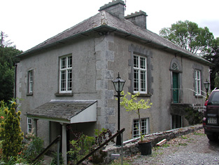
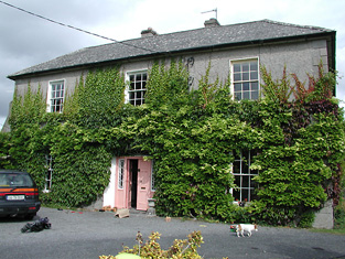
Arranhill
Houses within 5km of this house
Displaying 19 houses.
Houses within 5km of Arranhill
Displaying 19 houses.
| House name | Description | |
|---|---|---|
| Bellpark | Occupied by T. Robinson in 1837. The Ordnance Survey Name Books record Eyre C. Baldwin as the proprietor in 1840. It was occupied by Thomas Goold in the early 1850s. Goold held the house valued at £17+ with 116 acres from Denis Leonard and was the tenant at the time of house of the 1852 sale. A house is still extant at the site. | |
| Bellgrove | The home of the Leonard family in the first half of the 19th century. The Ordnance Survey Name Books refer to Geoffrey Leonard as the proprietor in 1840 but note that the house was not inhabited. It was held by Denis Leonard in fee at the time of Griffith's Valuation when the buildings were valued at £25.10 shillings. This house was unoccupied at the time of the 1852 sale. It appears to have been bought by Hyacinth Richard Daly, who advertised it for sale again in 1863. The sale rental states that the dwelling house was in "an unfinished state". Bellgrove no longer exists. | |
| Drominagh Lodge | According to the sale rental of November 1853 Dr Frederick Biggs had built a handsome residence in Shanakill for a sum exceeding £1,000. Drominagh Lodge is marked on the first edition Ordnance Survey map. Griffith's Valuation records Frederick Biggs as the occupier of the house valued at £13. He held the property from Edward Biggs. This house has been the home of the Fogarty family since the late 19th century. |
|
| Spring Park | In the mid 19th century Benjamin Armitage occupied a house valued at £10 in Gortnagrann which he held with 243 acres from William Woods. The Ordnance Survey Name Books note it as being occupied by Mr. Armitage in 1841. The site is now occupied by farm buildings. | |
| Milford | Lewis records Milford as the occasional residence of Ralph Smith. By the early 1850s it was occupied by Thomas Bunbury and held from William Woods. Bence Jones writes that it was the home of Edmond Murphy who died in 1882. In 1840, he Ordnance Survey Name Books refer to the house as the residence of John Monsell and describe the demesne as "principally composed of plantation and ornamental grounds". |

|
| Ormond Cottage | Ormond Cottage was the residence of Samuel Waller in 1837 and is also noted in the Ordnance Survey Name Books which describe it as "a neat cottage". In the early 1850s he held it in fee and the buildings were valued at £15.10 shillings. It was included in the sale of 1856 sale. A building is still located at this site. | |
| Killavalla | Lewis records Killavalla as the seat of R. Johnston Stoney. The Ordnance Survey Name Books refer to the house in this townland as "Honeywood House, the residence of Robert Johnstone Stoney, very commodious with convenient offices attached". Stoney's representatives held the property valued at £16+ from the representatives of Stephen Egan at the time of Griffith's Valuation. It later became the seat of the Saunders family. This house no longer exists. |
|
| Greyfort Cottage [later Greyfort House] | The Stoneys were residing at Greyfort from at least the 1770s as recorded by Taylor and Skinner and also by Wilson in 1786. A house known as Greyfort Cottage was marked on the first edition Ordnance Survey map at this location and is also mentioned in the Ordnance Survey Name Books which refers to it as "a good dwelling house, the residence of Henry Owen Saunders". On later maps a different building in the townland is known as Greyfort House. Biggs A. Stoney was living at Grey-fort, Borrisokane, in 1814 and Saunders is recorded as the proprietor by Lewis. William Gray was the occupier of a house in Greyfort townland, valued at £12+, at the time of Griffith's Valuation and held from Henry O. Saunders. Thomas R. Grey of Greyfort House owned 500 acres in the 1870s. Buildings are still extant at this site. | |
| Kyle Park | Marked on the first edition Ordnance Survey map Kyle Park was occupied by Thomas G. Stoney at the time of Griffith's Valuation and held by him in fee. It was valued at £39. The Ordnance Survey Name Books had described it as " a new and commodious house built and occupied by T.G. Stoney". The Stoneys still lived at Kyle Park in the 1870s. This house is still extant. |
|
| Finnoe | Occupied by T. [Thomas Maunsell] Waller in 1837. The Ordnance Survey Name Books describe Finnoe as "a commodious house" in 1840. Thomas' son, Edward Waller, was the occupier at the time of Griffith's Valuation. Edward held the property in fee and the house was valued at £30. A building is still located at this site. | |
| Oldcourt | John Brereton of Oldcourt was the second son of John Brereton of Rathurles and his wife, Margaret Watson. He had a son,John, born 1817. The Ordnance Survey Name Books refer to it as his property in 1840 but mention that it was "a commodious house" occupied by his land steward. John Brereton held Oldcourt in fee at the time of Griffith's Valuation when the house was valued at £12. A building is still extant at this site. | |
| Rodeen | A Falkiner residence from at least 1837. It was the home of Joseph Falkiner who held the property in fee. He was one of the eleven sons of the Reverend R.D. Falkiner of Mount Falcon. The house was valued at £22. It was advertised for sale in July 1860, Mrs Anne Falkiner and Richard J. Falkiner were the tenants. The house came on the market again in May 1867, part of the 105 acres for sale at Rodeen, the estate of Octavius La Touche. This house is still in use as a residence. |

|
| Bushy Park | Bushy Park was the home of Thomas Towers in 1814 and in 1837. In 1840, the Ordnance Survey Name Books refer to it as " a comfortable house, the residence of Thomas Towers" and also include reference to a letter written by Mr. Towers in which he expressed the wish that the house would revert to the name Shesharaghmore house though this does not seem to have happened. Sarah Cambie was occupying the house valued at £15 and held from Thomas Towers in the mid 19th century. David Clarke is described as "of Bushy Park, Borrisokane and Macclesfield" in the 1870s. Still valued at £15 this house was held by the representatives of David Clarke in 1906. A building is still extant at the site. | |
| Fort Nisbitt | Robert Nesbett was resident at Fort Nesbett in 1814. The Ordnance Survey Name Books also mention him in 1839 though they refer to Thomas Towers as the proprietor of the townland. In the early 1850s, Thomas O'Brien was the occupier, holding the property from the Reverend James Nesbitt. The buildings were valued at £12.15 shillings. A building is still located at this site. | |
| Newlawn | Originally a Carroll home that passed through marriage to the Dempsters. The Ordnance Survey Name Books mention J.Dempster as the proprietor of Newlawn in 1839 though elsewhere they refer to it as the residence of Mr. Egan, distiller. In the mid 19th century David Dempster was the occupant holding the property from Dr Dempster, the buildings were valued at £13.15 shillings. The building is still in use as a house. |
|
| Ballinderry | In 1840 the Ordnance Survey Name Books refer to Ballinderry House as "a good house in a demesne with some trees". James Demspter was noted as the proprietor at the time. By the time of Griffith's Valuation it appears to be the mill manager's house, occupied by William Egan and held from Timothy Hogan, part of a building complex valued at £97, known as Santa Cruise Mills. Now in use as a private residence. |
|
| Ashgrove | Lewis records B. Talbot as resident. In 1840 the Ordnance Survey Name Books record that the house derived its name from "a large ash grove, recently cut away". A house valued at £15+ at the time of Griffith's Valuation when it was occupied by Reverend Benjamin Talbot and held from Sir John Power. Reverend Benjamin was still resident in the 1870s. Ash Grove is still extant. |
|
| Derrinvohil | This house was not built at the time of the first Ordnance Survey. It bears the name of a townland but was originally located in the townland just to the west of Derrinvohil. The townland boundary has now altered and the house is in the townland of Derrinvohil. It was built by James Jocelyn Poe in 1845. Valued at £17 at the time of Griffith's Valuation and held from the Messrs Saurin. The house continues to function as a residence. |
|
| Fort Henry [Greyfort Cottage] Borrisokane | In 1840, the Ordnance Survey Name Books refer to "Fort Henry, a commodious house, the residence of Henry Ely" in the townland of Greyfort, parish of Borrisokane. At the time of Griffith's Valuation, Henry Ely was leasing a property valued at almost £5 from the Saunders estate in this townland. This may refer to the property shown on the 1st edition Ordnance Survey map as Greyfort House. On the later 25-inch map of the 1890s it is known as Greyfort Cottage. A house is still extant at the site. |