Mountalt
Houses within 5km of this house
Displaying 14 houses.
Houses within 5km of Mountalt
Displaying 14 houses.
| House name | Description | |
|---|---|---|
| Castle Fogarty | Lewis writes that Castle Fogarty was "the ancient seat of the O'Fogarty family from whom it descended to the present proprietor J. Lanigan". He describes it as a "square castellated mansion, with embattled towers at the angles". The seat of the Lenigan family in the 18th and 19th centuries [held from the Earls of Portarlington until the fee was purchased in the mid 19th century]. Noted by Slater as the seat of Captain Vivian Ryan-Lanigan in 1894. A ruin since it was burnt in 1922. |
|
| Crossoge | Lewis refers to Prior Lodge as the residence and property of the Reverend Dr Prior. The house in Crossoge is named Prior Lodge on the first edition Ordnance Survey map. This house appears to have been replaced by another building, a short distance to the south, known as Crossoge House sometime in the mid 19th century. Occupied and held in fee with 92 acres by the Reverend John Prior at the time of Griffith's Valuation when the buildings were valued at £25.15 shillings. This house is still in use as a country residence. [This may be the house to which Wilson, writing in 1786, refers to as"Bachelor's Lodge", in this area, which was a seat of Mr. Roe]. |
|
| Ballynera | The residence of Richard Pennefather in 1837 and at the time of Griffith's Valuation when the house was valued at £10 and held in fee. A house is still extant at the site. | |
| Moyaliff | Mealiffe was the residence of the Reverend William Armstrong in 1837 (the Chancellor) and of John Armstrong in the early 1850s. John Armstrong held the property from Colonel Pennefather and the buildings were valued at £29.10 shillings. Moyaliff was the residence of Edward Marcus Armstrong in the 1880s. Mark Armstrong occupied this house in 1906. This house, which incorporates building from the 18th and 19th century, is still a residence. |

|
| Ballycahill | A house at Ballycahill valued at £11+ was occupied by Mrs Mary Cormack at the time of Griffith's Valuation and held from Doctor Wall. | |
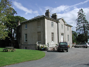
| Farney Castle | A seat of a branch of the Armstrong family. Wilson refers to this property as Farney Bridge in 1786, a seat of Mr. Armstrong. It was occupied by Captain Armstrong in 1814 and 1840, when the Ordnance Survey Name Books describe it as "a circular old castle to which a gentleman's residence has been attached". Major William Armstrong was the occupier in the early 1850s. The buildings were then valued at £42.10 shillings and held from the Reverend Garrett Wall. It was still in Armstrong possession in the 1870s. Farney Castle is still extant and occupied. |

|
| Raheen Park | Located south east of Farneybridge this house was occupied by Edward Wilson in the mid 19th century, valued at £34 and held from William B. Armstrong. Raheen Park may have been previously known as Brasfort. Brasfort was the home of the Wilsons in the 1830s. Edward Wilson was Chief Magistrate of Police in county Tipperary in the 1820s. In 1820, his son, Edward Wilson, married Isabella, daughter of Thomas Goodricke Peacock of Fort Etna and they had a son, Thomas Goodricke Wilson, who married Mary Studdert in 1861 and emigrated to Canada. In 1840 the Ordnance Survey Name Books refer to E. Wilson as the proprietor of Raheen Park. Edward Wilson of Raheen Park died at Monkstown, county Dublin in 1880, aged 81, (see D.23260 in the National Archives). | |
| Bouladuff | A house beside the main road from Thurles to Borrisoleigh, occupied by Thomas O'Meara and held from the Earl of Clonmel in the mid 19th century, when the buildings were valued at £12.13 shillings. The Ordnance Survey Name Books also note it as the residence of "Mr. Thomas Omar". |
|
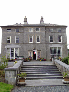
| Inch | An 18th century building which was the seat of the Ryan family. The Irish Tourist Association Survey records that the Ryans, a Catholic family, came from Munroe to Inch and that their lands were held for them by Aneas Burke of Kilkenny during Penal Times. Wilson, writing in 1786, refers to Inch as the seat of Mr. Ryan. The house was occupied by Daniel Ryan in 1814. Daniel died in 1831 and was succeeded by his brother, George Ryan,who was resident in 1837. The house was valued at £53 at the time of Griffith's Valuation and was held in fee by George Ryan. It was recorded by Slater as the seat of George E. Ryan in 1894. The Ryans continued to live at Inch House until 1985 when it was sold to John and Nora Egan. The building now functions as a county house and restaurant run by the Egan family, see http://www.inchhouse.ie/about-us/a-brief-history-of-inch-house/ |
|
| Liscahill [Lodge] | The Ordnance Survey Name Books indicate that Liscahill House was the residence of P. Ryan in 1840 though it also refers to Liscahill Lodge, the residence of Mr. Baker. A vacant house valued at £12+ was located in this townland held by William Baker senior in the mid 19th century. Buildings are still located at this site. | |
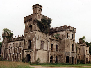
| Gortkelly Castle | The National Inventory of Architectural Heritage dates this house from circa 1800. It is a five-bay house with three storeys. Gortkelly House is marked on the 1st edition Ordnance Survey map as a relatively small house but had increased in size by the end of the 19th century when named Gortkelly Castle. Gortkelly was the home of the Ryan family from the mid 18th century. John Ryan was resident in 1814. In the mid 19th century the house was held from Peter Graham [Grehan] by Andrew Ryan and was valued at £6.5 shillings. It is now a ruin. | |
| Beakstown House | Major Ledwell was resident at Beakstown in 1837 and the Ordnance Survey Name Books also mention it as his residence in 1840. At the time of Griffith's Valuation one house at Beakstown appears to be in use as an auxiliary poorhouse, held by the Reverend George Peacock from the Court of Chancery and valued at £22+. Another property seems to be labelled Abbey View on the 1st Edition Ordnance Survey map but as Beakstown Cottage on the 25-inch map of the 1890s. The OS Name Books refer to this house as the residence of Mr. Mullvany, proprietor of Beakstown Flour Mills nearby. The name Beakstown Cottage had previously belonged to another property in Beakstown which is still extant [S087559]. The original Beakstown House does not appear to be extant. | |
| Abbeyfield / Gortnagowth | In 1840 the Ordnance Survey Name Books refer to Abbeyfield House as the residence of William Jones. At the time of Griffith's Valuation, Jeremiah O'Brien was leasing this property from the Wall estate when it was valued at £15+ and included a mill. It is labelled Abbeyfield on the 1st edition Ordnance Survey map but as Gortnagowth on the 25-inch map of the 1890s. It is still extant. | |
| Whitefort House | The Ordnance Survey Name Books refer to Whitefort House as a gentleman's residence in 1840. At the time of Griffith's Valuation, this property was leased by John Jones from the Wall estate when it was valued at almost £10. It is still extant. |