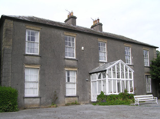
Graiguenoe
Houses within 5km of this house
Displaying 11 houses.
Houses within 5km of Graiguenoe
Displaying 11 houses.
| House name | Description | |
|---|---|---|
| Gaile | Gaile was the home of the Phillips family in the 19th century, occupied by S. Phillips in 1837 and by Richard Phillips in 1850. It was held from Benjamin Bunbury with 749 acres and was valued at £37+. The Phillips continued to reside at Gaile until at least the mid 20th century. This house was vacant in the early 21st century. |
|
| Regaile | In 1840 the Ordnance Survey Name Books record Rev. Mr. Joice as the occupant of Regeale. The Reverend Robert Armstrong occupied the house at the time of Griffith's Valuation holding it from Richard Phillips. The buildings were valued at £20.18 shillings.A house is still extant at Regaile. | |
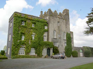
| Killough | A 16th century tower house with a number of additions, Lewis records Killough Castle as the "occasional residence" of the Honourable Mrs Plunkett. In 1850 the Honourable Bowes Daly occupied the castle valued at £22.14 shillings which he held in fee. |
|
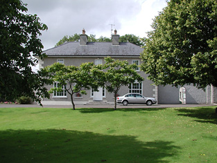
| Moyaliff | Mealiffe was the residence of the Reverend William Armstrong in 1837 (the Chancellor) and of John Armstrong in the early 1850s. John Armstrong held the property from Colonel Pennefather and the buildings were valued at £29.10 shillings. Moyaliff was the residence of Edward Marcus Armstrong in the 1880s. Mark Armstrong occupied this house in 1906. This house, which incorporates building from the 18th and 19th century, is still a residence. |

|
| Farney Castle | A seat of a branch of the Armstrong family. Wilson refers to this property as Farney Bridge in 1786, a seat of Mr. Armstrong. It was occupied by Captain Armstrong in 1814 and 1840, when the Ordnance Survey Name Books describe it as "a circular old castle to which a gentleman's residence has been attached". Major William Armstrong was the occupier in the early 1850s. The buildings were then valued at £42.10 shillings and held from the Reverend Garrett Wall. It was still in Armstrong possession in the 1870s. Farney Castle is still extant and occupied. |

|
| Cabragh Castle | The home of James Fogarty in 1814. In 1840 the Ordnance Survey Name Books refer to P. Fogarty as the proprietor of "Cabra House". Denis Leahy was the occupier in the mid 19th century when the castle was valued at £16+ and held from the Court of Chancery. | |
| Raheen Park | Located south east of Farneybridge this house was occupied by Edward Wilson in the mid 19th century, valued at £34 and held from William B. Armstrong. Raheen Park may have been previously known as Brasfort. Brasfort was the home of the Wilsons in the 1830s. Edward Wilson was Chief Magistrate of Police in county Tipperary in the 1820s. In 1820, his son, Edward Wilson, married Isabella, daughter of Thomas Goodricke Peacock of Fort Etna and they had a son, Thomas Goodricke Wilson, who married Mary Studdert in 1861 and emigrated to Canada. In 1840 the Ordnance Survey Name Books refer to E. Wilson as the proprietor of Raheen Park. Edward Wilson of Raheen Park died at Monkstown, county Dublin in 1880, aged 81, (see D.23260 in the National Archives). | |
| Beakstown House | Major Ledwell was resident at Beakstown in 1837 and the Ordnance Survey Name Books also mention it as his residence in 1840. At the time of Griffith's Valuation one house at Beakstown appears to be in use as an auxiliary poorhouse, held by the Reverend George Peacock from the Court of Chancery and valued at £22+. Another property seems to be labelled Abbey View on the 1st Edition Ordnance Survey map but as Beakstown Cottage on the 25-inch map of the 1890s. The OS Name Books refer to this house as the residence of Mr. Mullvany, proprietor of Beakstown Flour Mills nearby. The name Beakstown Cottage had previously belonged to another property in Beakstown which is still extant [S087559]. The original Beakstown House does not appear to be extant. | |
| Holycross House | In 1840 the Ordnance Survey Name Books refer to Holycross House as a gentleman's residence. At the time of Griffith's Valuation, it was owned by Rev. Garret Wall but was unoccupied. The house was valued at almost £24. A house still stands at this site which now appears to be in use as a presbytery. |
|
| Abbeyfield / Gortnagowth | In 1840 the Ordnance Survey Name Books refer to Abbeyfield House as the residence of William Jones. At the time of Griffith's Valuation, Jeremiah O'Brien was leasing this property from the Wall estate when it was valued at £15+ and included a mill. It is labelled Abbeyfield on the 1st edition Ordnance Survey map but as Gortnagowth on the 25-inch map of the 1890s. It is still extant. | |
| Whitefort House | The Ordnance Survey Name Books refer to Whitefort House as a gentleman's residence in 1840. At the time of Griffith's Valuation, this property was leased by John Jones from the Wall estate when it was valued at almost £10. It is still extant. |