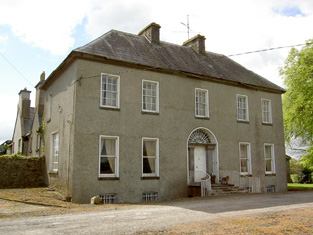
Mohober
Houses within 10km of this house
Displaying 22 houses.
Houses within 10km of Mohober
Displaying 22 houses.
| House name | Description | |
|---|---|---|
| Harley Park | The Poe residence at this location in the 18th century was known as Rosenaharly as mentioned by Wilson in 1786. The seat of the Poe family, occupied by James Poe in 1814 and by J.P. Poe in 1837. James Purefoy Poe was still resident in the mid 19th century, holding the property in fee. The buildings were valued at £41.10 shillings. The Poes were still resident in the early 20th century and this house is still a residence. |
|
| Ballyphilip | The seat of the Going family in the 18th and 19th centuries, W. and A. Going were resident in 1814 and Ambrose Going held the property in fee at the time of Griffith's Valuation. The buildings were valued at £30.15 shillings. This house was held by the representatives of B.F. Going in 1906. Buildings are still extant at the site. | |
| Coalbrook | A Langley home in the 18th and 19th centuries. The Ordnance Survey Name Books describe the demesne as "nearly one half wood and oranmental ground" in 1838. It was valued at £35.10 shillings in the mid 19th century when held by Henry Langley in fee. George Langley was the occupier in 1906 when the buildings were valued at £41+. This house is still extant and lived in. |
|
| Lisnamrock Castle | The Langleys were resident here from the 18th century. Wilson, writing in 1786, refers to Lisnarock as the seat of Mr Langley. Henry Langley was the occupier in the mid 19th century, holding the property in fee. The buildings were valued at £11.10 shillings. Held by George Langley in 1906. Buildings still exist at this location. | |
| Glenview | Glenview was occupied by the Reverend Edmund Prendergast in the early 1850s. He held the house valued at £18.15 shillings from Matthew Prendergast. In the early 20th century the house was altered and extended by a religious order who set up a school. |
|
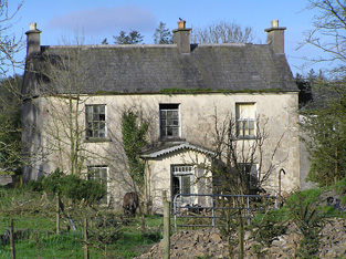
| Wilford | Wilford was the residence Butler Esq in the 1770s and 1780s and of Mr Richard Blackmore in 1814. In the early 1850s it was occupied by John Blackmore, who held the property valued at £11+ from William P. Barker with 128 acres. The house is labelled Wilford House on the 1st edition Ordnance Survey map but as Shangarry House on the 25-inch edition of the 1890s. It is now a ruin. | |
| Willmount | Occupied in 1814 by Robert Lane and by Hampden Lane in the early 1850s, when the house was valued at £17 and held from William P. Barker. This house is still an occupied residence. |
|
| Ballylanigan (Cramer) | [Thomas Pennefather is recorded as resident at Ballylanigan (Pennefather?) in 1814]. Lewis refers to the Cramer family of Ballylanigan. At the time of Griffith's Valuation Ballylanigan (Cramer) was occupied by Thomas Sexton and held from Mrs Catherine Reeves. The buildings were valued at £17+. This house still exists. | |
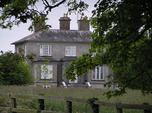
| Hilton | This house is not marked on the first Ordnance Survey map. The National Inventory of Architectural Heritage dates the house circa 1850. At the time of Griffith's Valuation the representatives of J. Stephens held most of this townland from the Pennefathers. The home of the Grant family from at least the 1870s. Slater refers to it as the seat of Colonel G. Fox Grant in 1894. Valued at £22+ in 1906 and occupied by Joseph B. Grant. It is still extant. in 2015 it was offered for sale. |

|
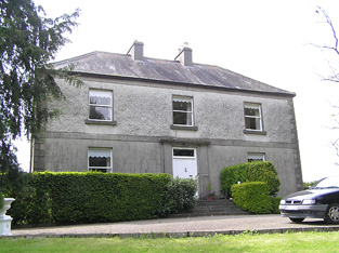
| Ballywalter | Occupied in the early 1850s by John Doherty, valued at £12 and held from the [Reverend] John Burdett, uncle of Arthur Burdett. | |
| Gurteen | Thomas Bryan was the proprietor of Gorteen, Callan, in 1814 and Lewis records Gurteen as the home of the Reverend W. O'Brien [Bryan?]. The Reverend William Bryan held the property in fee at the time of Griffith's Valuation when the buildings were valued at £10.15 shillings. Members of the Bryan family were still resident at Gurteen in the 1980s. Buildings still exist at this location. | |
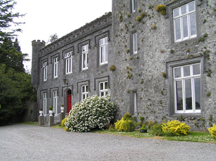
| Killaghy | This is an old tower house which has been altered and remodelled. In the 1770s and 1780s it was the home of Greene Despard Esq. In 1837 Lewis refers to W. Despard as the proprietor of Killaghy ‘which was the residence of Baron Tobin, and was taken by Cromwell, who gave it to a Col. Green, from whom it has descended to its present proprietor’. Griffith's Valuation also records William Despard as the occupier. He held the house valued at £23 from Sir Riggs Falkiner. Bence Jones writes that Killaghy passed from the Despards to the Wrights by inheritance. Hubert H Fox of Killaghy Castle owned 321 acres in county Tipperary in the 1870s. In 1894 Slater refers to it as the seat of Miss M.A. Walpole. Killaghy has had a number of owners in the 20th century and continues to function as a country residence. For sale in 2010 see http://www.michaelhdaniels.com. |
|
| Oakfield | A house occupied by Purefoy Poe in 1814 and by the Reverend Daniel Corcoran in the early 1850s, when it was held from the representatives of R. Constable junior and valued at £15.10 shillings. The Ordnance Survey Name Books mention that there was a garden, fir plantation and planted ornamental ground attached to Oakfield House. Renovated in the 1930s it is still extant and inhabited. |
|
| Kyle | A house occupied by Matthew R. Millett at the time of Griffith's Valuation, valued at £10 and held from Colonel W. Palliser. | |
| Ballyrichard | The Ordnance Survey Name Books describe Ballyrichard as "a good farmer's hosue with offices and garden" in 1840. The house, valued at £12.18 shillings, was occupied by Matthew Hughes and held from Colonel W. Palliser at the time of Griffith's Valuation. Richard H. Hughes of Ballyrichard owned 597 acres in the 1870s. A substantial farm is still extant at the site. | |
| Langley Lodge | In 1840 the Ordnance Survey Name Books refer to Langley Lodge as "a good house with offices and garden". This house was occupied by Mrs Mary Langley in the early 1850s. She held it from Henry Langley and the buildings were valued at £19.19 shillings. By the time of the sale in December 1853 John Kane was resident. A building is still extant at this site. | |
| Ballydavid | In the mid 19th century Patrick Murphy held a house valued at £10 from Thomas Power in the townland of Ballydavid. | |
| Slievardagh | In 1906 John H. Lanphier held buildings valued at £18+ in the townland of Blackcommon part of the village of Commons, probably Slievardagh House. This house is not marked on the first edition Ordnance Survey map. |
|
| Hilton | A house built after the publication of the 1st Ordnance Survey map. The home of the Grant family from at least the 1870s. Slater refers to it as the seat of Colonel G. Fox Grant in 1894. Valued at £22+ in 1906 and occupied by Joseph B. Grant. It is still extant. In 2015 it was offered for sale. |
|
| Cloonyhea | A house valued at £11+ was occupied by Thomas Mansfield at Cloonyhea in the mid 19th century. It was held from John Bradshaw. A small house is marked on the first edition Ordnance Survey map at this location. It had increased considerably in size on later maps, still extant. | |
| Coolquill Castle | In 1786 Wilson refers to Coolquill as the seat of Mr. Gahan. The property is labelled "Coolquill Castle" on the 1st edition Ordnance Survey map and indicates that it was built on to a tower house. Coolquill was held in fee by Colonel Palliser in the mid 19th century. He was married to Anne Glenstanes. The castle was valued at £5. The castle ruin and other buildings are still extant at the site. | |
| Venter Fair | The Ordnance Survey Name Books refer to this house in the townland of Clashduff, parish of Ballingarry as "Venture Fair" and note the existence there of coal mines of the same name. At the time of Griffith's Valuation, it was leased by Mrs. Mary O'Sullivan from the Langley estate and valued at almost £10. A house is still extant at the site. |