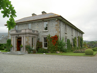
Ballyboe
Houses within 5km of this house
Displaying 16 houses.
Houses within 5km of Ballyboe
Displaying 16 houses.
| House name | Description | |
|---|---|---|
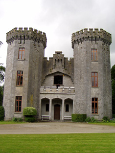
| Anner Castle | Marked on the first Ordnance Survey map as Ballina House, this residence of the Reverend Nicholas Manderville was valued at £46+ and held by him in fee in the early 1850s. Bence Jones writes that Anner Castle was built in the 1860s "incorporating the old square castle of the Manderville family which had up till then been known as Ballinahy". It was destroyed by fire in 1926 and only the front portion was rebuilt. The Mandervilles were still resident in the 20th century. This property was sold in 2013. |
|
| Anner Ville | Anner Ville was the home of Pierce A. Butler in 1814 but by 1837 was in Riall possession. The Ordnance Survey Name Books describe it as "handsomely situated, having a garden, orchard and ornamental ground attached". At the time of Griffith's Valuation Samuel Riall held the house valued at £23.14 shillings from Barclay Clibburn junior. Anner Ville continued to be a Riall residence in the 1870s and is still a fine home. |
|
| Redmondstown | In 1814 Redmondstown was the residence of J. Parson Ducket and in 1837 of a member of the Quinn family. In the early 1850s R.G. Fitzgerald was the occupier, holding the house valued at £16.15 shillings from the Earl of Glengall. This house is still extant and is located in a wooded area. Thomas Albert Quin of Redmondstown owned 612 acres in the 1870s. | |
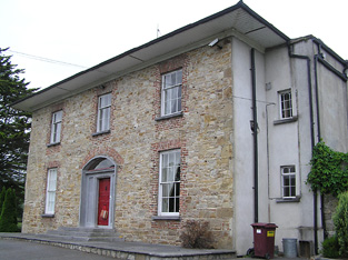
| E.T.M. Ville | E.T.M. Ville, Clonmel was occupied by E.T.M. Butler [Edmond Theobald Mandeville Butler] in 1814 and by his widow Mrs Eliza Butler in the mid 19th century. The house was then valued at £13 and held from the Putland/Hulse estate. Some buildings remain at the site. | |
| Anner Park | In 1837 Lewis records the extensive flour mills and residence of Barclay Clibborn in the parish of Kilgrant. In 1840 the Ordnance Survey Name Books describe the townland of Twomilebridge as " a demesne, consisting of planted ornamental ground, gardens and orchard". In the mid 19th century Barclay Clibburn occupied a house valued at £22 and held from the Putland/Hulse estate. Joseph Clibburn of Two mile bridge owned 20 acres in the 1870s. William Clibborne was resident in 1906 when the house was valued at £30+. This house is still occupied and well maintained. |
|
| Ballyvaughan | The Bushell family were located at Ballyvaughan from the 18th century. The will of Edward Bushell of Ballyvaughan dated 30 July 1778 names his six sons. At the time of Griffith's Valuation Samuel Bushell held buildings valued at almost £13 from John Lindsey. http://www.igp-web.com/IGPArchives/ire/tipperary/wills/bushell01.txt | |
| Kilheffernan/Cottage | Thomas Ryan was the proprietor of Cottage, Clonmel, in 1814 and Lewis records T. Ryan of Cottage, parish of Killaloan. At the time of Griffith's Valuation Patrick Fennelly held the house valued at £10.13 shillings from Thomas Ryan. Altered over the years this house is still in use as a residence. |
|
| Lindville | A house named Lindville is marked on the first Ordnance Survey map in this townland close to the bank of the River Suir. At the time of Griffith's Valuation it was valued at £16+ and occupied by Thomas Lindsey who held it from William Butler. No building is now extant at this site. | |
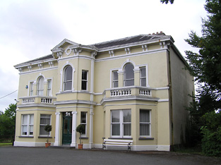
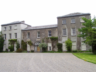
| Newtown Anner | The seat of the Osborne family, held by R.B. Osborne MP in fee in the mid 19th century when the buildings were valued at £56+. Inherited by 12th Duke of St Albans, grandson of R.B. Osborne. Occupied by the Duchess of St Albans in 1906 and still in this family's possession in the early 1940s. The Irish Tourist Association survey states that the Osbornes bought the property from Clonmel Corporation in 1774. The National Inventory of Architectural Heritage dates this house 1829. It continues to be in use as a residence. |
|
| Ballyknockane | Marked on the first Ordnance Survey map as Ballyknockane Cottage, valued at £21 and occupied by Walter Asper at the time of Griffith's Valuation. He held the property from the Marquess of Ormonde. In 1894 Slater noted it as part of the latter estate. This building no longer exists. | |
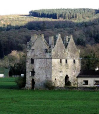
| Tikincor Castle | Tickincor Castle, a fortified house, is described as "in ruins" on the first edition Ordnance Survey map in 1840. Buildings at the site were valued at £7 18s at the time of Griffith's Valuation in the 1850s when they were owned by Ralph B. Osborne and leased to Thomas Prendergast. In 1777 Smith notes that Tickencore was the property of Sir William Osborne. |
|
| Gurteen Le Poer/Gurteen House | Held in fee by John Power in 1850 when it was valued at over £96. In 1837 Lewis noted Gurteen as the seat of E. Power. Count Edmond de la Poer was the owner in 1894 and 1906 when the house was valued at £87. By the later nineteenth century it had come to be called Gurteen Le Poer, the name by which it is still known. |
|
| Landscape House | John Congreve held Landscape in fee in 1850 when it was valued at almost £20. Lewis also refers to it as a seat of the Congreve family in 1837. However, by 1906 Congreve's buildings at Landscape were only valued at £2. Landscape House is still extant and occupied. |
|
| Poulboy Mill House | Winifred Daniel was leasing this property from the Osborne estate at the time of Griffith's Valuation, when it was valued at £13 10s. The adjacent mill, valued at £42, was being leased by her to Patrick Corcoran at the same time. By the 1880s the mill is no longer visible. | |
| Ballyglasheen | This house is not marked on the first edition Ordnance Survey map. The Inventory of Irish Architecture dates this house circa 1870. It was occupied in the 1870s by John Barnes. It is still extant and well maintained. |
|
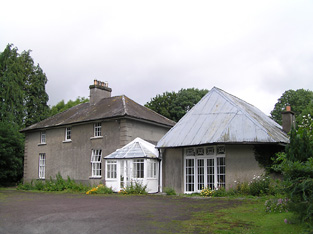
| Milltown House | In the mid 19th century Henry Briscoe was occupying a house valued at £10.19 shillings and held from Captain Richard Long. This house is still extant. |